Tag Archives: Porto Alegre

Tropical Storm Akara Forms Over South Atlantic Ocean

Tropical Storm Akara formed over the South Atlantic Ocean during Monday night. At 7:00 a.m. EST on Tuesday the center of Tropical Storm Akara was located at latitude 32.0°S and longitude 42.0°W which put it about 550 miles (885 km) east-southeast of Porto Alegre, Brazil. It was moving toward the south at 5 m.p.h. (8 km/h). The maximum sustained wind speed was 45 m.p.h. (75 km/h) and there were wind gusts to 60 m.p.h. (95 km/h). The minimum surface pressure was 993 mb.

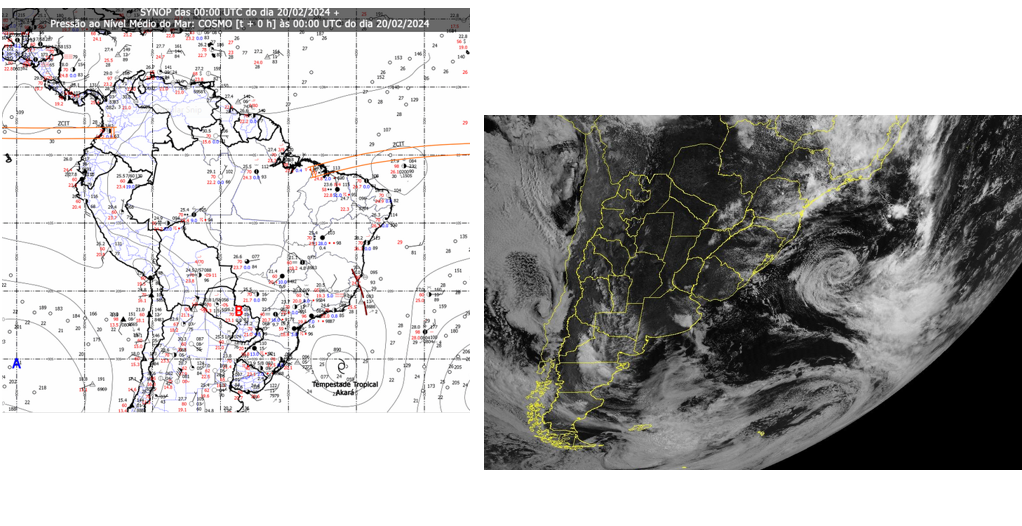
The Instituto Nacional de Meteorologia (INMET) in Brazil designated a former subtropical cyclone over the South Atlantic Ocean southeast of Brazil as Tropical Storm Akara on Monday night. There was a well defined center of circulation in the lower levels of the atmosphere. Bands of showers and lower clouds were revolving around the center of Tropical Storm Akara. A stronger rainband coiled around the western and northern side of Akara’s circulation.

Tropical Storm Akara will move through an environment unfavorable for intensification during the next 24 hours. Akara will move over water where the Sea Surface Temperatures are near 24°C. It will move under the western part of an upper level ridge over the South Atlantic Ocean. The upper level ridge will produce northerly winds that will blow across the top of the subtropical cyclone. Those winds will cause moderate vertical wind shear. The moderate wind shear and marginal Sea Surface Temperatures are likely to cause Tropical Storm Akara to weaken slowly during the next 24 hours.

Tropical Storm Akara will move around the western side of a high pressure system over the South Atlantic Ocean. The high pressure system will steer Akara slowly toward the south during the next 24 hours. On its anticipated track, Tropical Storm will remain east of South America.

Subtropical Cyclone Develops Over South Atlantic Ocean

A subtropical cyclone developed over the South Atlantic Ocean southeast of Brazil on Monday. At 1:00 p.m. EST on Monday the center of a subtropical cyclone was located at latitude 30.0°S and longitude 42.0°W which put it about 570 miles (920 km) east-southeast of Porto Alegre, Brazil. It was moving toward the southwest at 4 m.p.h. (6 km/h). The maximum sustained wind speed was 45 m.p.h. (75 km/h) and there were wind gusts to 60 m.p.h. (95 km/h). The minimum surface pressure was 996 mb.

A low pressure system over the South Atlantic Ocean southeast of Brazil exhibited more organization on Monday and the National Institute of Meteorology in Brazil classified the system as a subtropical depression. The subtropical cyclone had a well defined center of circulation in the lower levels of the atmosphere. Bands of showers and lower clouds were revolving around the center of circulation. A stronger rainband coiled around the northern and western side of the subtropical cyclone.

The subtropical cyclone will move through an environment unfavorable for intensification during the next 24 hours. It will move over water where the Sea Surface Temperatures are near 24°C. The subtropical cyclone will move under the western part of an upper level ridge over the South Atlantic Ocean. The upper level ridge will produce strong northerly winds that will blow across the top of the subtropical cyclone. Those winds will cause strong vertical wind shear. The strong wind shear and marginal Sea Surface Temperatures are likely to cause the subtropical cyclone to weaken slowly during the next 24 hours.

The subtropical cyclone will move around the western side of a high pressure system over the South Atlantic Ocean. The high pressure system will steer the subtropical cyclone slowly toward the south during the next 24 hours. On its anticipated track, the subtropical cyclone will remain east of South America.