Monthly Archives: November 2023

Former Tropical Storm Ramon Weakens

Former Tropical Storm Ramon weakened over the Eastern North Pacific Ocean southwest of Baja California on Sunday. At 10:00 a.m. EST on Sunday the center of former Tropical Storm Ramon was located at latitude 14.4°N and longitude 123.9°W which put it about 1085 miles (1750 km) west-southwest of the southern tip of Baja California. Ramon was moving toward the west at 7 m.p.h. (11 km/h). The maximum sustained wind speed was 35 m.p.h. (55 km/h) and there were wind gusts to 45 m.p.h. (75 km/h). The minimum surface pressure was 1006 mb.

A large upper level trough over the Eastern North Pacific Ocean produced strong southwesterly winds that blew the top off of former Tropical Storm Ramon. The remaining circulation of former Tropical Storm Ramon in the lower levels consisted primarily of bands of showers and lower clouds. Strong upper level winds blew the tops off of any clouds that rose higher in the atmosphere.

Former Tropical Storm Ramon will move through an environment that will be unfavorable for intensification during the next 36 hours. Ramon will move over water where the Sea Surface Temperatures are near 27°C. However, the large upper level trough over the Eastern North Pacific will continue to produce strong southwesterly winds. Those winds will cause strong vertical wind shear. The strong wind shear will cause formed Tropical Storm Ramon to weaken during the next 36 hours.

Since the circulation of former Tropical Storm Ramon only exists in the lower levels of the atmosphere, it will be steered by the winds near the surface of the Earth. Former Tropical Storm Ramon will move south of a surface high pressure system over the Eastern North Pacific. The high pressure system will steer former Tropical Storm Ramon toward the west during the next 36 hours.

TD 20E Strengthens to Tropical Storm Ramon

Former Tropical Depression Twenty-E strengthened to Tropical Storm Ramon over the Eastern North Pacific Ocean southwest of Baja California on Friday evening. At 10:00 p.m. EST on Friday the center of Tropical Storm Ramon was located at latitude 13.8°N and longitude 122.6°W which put it about 1040 miles (1675 km) southwest of the southern tip of Baja California. Ramon was moving toward the north at 5 m.p.h. (8 km/h). The maximum sustained wind speed was 40 m.p.h. (65 km/h) and there were wind gusts to 50 m.p.h. (80 km/h). The minimum surface pressure was 1005 mb.

Former Tropical Depression Twenty-E exhibited more organization on Friday evening and the U.S. National Hurricane Center upgraded it to Tropical Storm Ramon. The distribution of thunderstorms around Tropical Storm Ramon was still asymmetrical. Most of the thunderstorms were occurring in bands in the eastern side of Ramon’s circulation. Bands in the western side of the circulation consisted primarily of showers and lower clouds. The distribution of wind speeds was also asymmetrical, Winds to tropical storm force extended out 35 miles (55 km) in the eastern side of Ramon’s circulation. The winds in the western side of Tropical Storm Ramon were blowing at less than tropical storm force.

Tropical Storm Ramon will move through an environment somewhat favorable for intensification during the next 12 hours. Ramon will move over water where the Sea Surface Temperatures are near 27°C. It will move under the eastern part of an upper level trough over the Eastern North Pacific. The upper level trough will produce southwesterly winds that will blow toward the top of Ramon’s circulation. Those winds will cause moderate vertical wind shear. The wind shear will inhibit intensification, but it may not be strong enough to prevent some further intensification during the next 12 hours. Tropical Storm Ramon could intensify a little during the first half of Saturday. The upper level winds are forecast to get stronger later on Saturday. Stronger upper level winds would cause the vertical wind shear to increase. More wind shear would cause Tropical Storm Ramon to start to weaken.

Tropical Storm Ramon will move around the western part of a high pressure system over the Eastern North Pacific Ocean. The high pressure system will steer Ramon slowly toward the north during the next 24 hours. On its anticipated track, Tropical Storm Ramon will remain far to the southwest of Baja California.

Tropical Depression 20E Forms Southwest of Baja California

Tropical Depression Twenty-E (20E) formed over the Eastern North Pacific Ocean southwest of Baja California on Thursday. At 4:00 p.m. EST on Thursday the center of Tropical Depression Twenty-E was located at latitude 12.0°N and longitude 121.9°W which put it about 1090 miles (1755 km) southwest of the southern tip of Baja California. The tropical depression was moving toward the west-northwest at 3 m.p.h. (5 km/h). The maximum sustained wind speed was 35 m.p.h. (55 km/h) and there were wind gusts to 45 m.p.h. (75 km/h). The minimum surface pressure was 1005 mb.

A low pressure system over the Eastern North Pacific Ocean strengthened on Thursday and the U.S. National Hurricane Center designated the system as Tropical Depression Twenty-E. Tropical Depression 20E had a well defined low level circulation, but it was in an environment of strong vertical wind shear. The tropical depression was under the eastern part of an upper level ridge over the Eastern North Pacific Ocean. The ridge was producing northwesterly winds that were blowing toward the top of the tropical depression. Those winds were causing strong vertical wind shear. The wind shear was causing the distribution of thunderstorms to be asymmetrical. Bands near the center of Tropical Depression 20E and in the northwestern part of the circulation consisted primarily of showers and lower clouds. Some thunderstorms were occurring in bands in the southeastern part of the tropical depression.

Tropical Depression Twenty-E will move through an environment somewhat favorable for intensification during the next 24 hours. The tropical depression will move over water where the Sea Surface Temperatures are near 28°C. However, the upper level ridge over the Eastern North Pacific Ocean will continue to cause vertical wind shear. The wind shear will inhibit intensification. The northwesterly winds in the upper levels could weaken a little on Friday. Tropical Depression Twenty-E could intensify a little during the next 24 hours, if the wind shear decreases.

Tropical Depression Twenty-E will move around the southwestern part of a high pressure system over the Eastern North Pacific Ocean. The high pressure system will steer the tropical depression slowly toward the northwest during the next 24 hours. On its anticipated track, Tropical Depression Twenty-E will remain far to the southwest of Baja California.

Potential Tropical Cyclone Twentytwo Unlikely to Develop

Potential Tropical Cyclone Twentytwo is now unlikely to develop into a tropical depression or a tropical storm. At 10:00 p.m. EST on Friday the center of Potential Tropical Cyclone Twentytwo was located at latitude 20.0°N and longitude 76.5°W which put it about 85 miles (130 km) west of Guantanamo, Cuba. It was moving toward the northeast at 22 m.p.h. (35 km/h). The maximum sustained wind speed was 35 m.p.h. (55 km/h) and there were wind gusts to 45 m.p.h. (75 km/h). The minimum surface pressure was 1006 mb.

A low pressure system over the Caribbean Sea designated as Potential Tropical Cyclone Twentytwo is no longer expected to develop into a tropical depression or a tropical storm. An upper level trough over the Gulf of Mexico is producing strong southwesterly winds that are blowing across the top of the low pressure system. Those winds are causing strong vertical wind shear. The vertical wind shear is preventing the formation of thunderstorms near the center of Potential Tropical Cyclone Twentytwo. Thunderstorms are occurring in bands in the eastern part of the low pressure system. Bands in the western part of the system and near the center of circulation consist of showers and lower clouds.

Potential Tropical Cyclone Twentytwo will move through an environment unfavorable for development of a tropical cyclone during the next 36 hours. The low pressure system will move over water where the Sea Surface Temperatures are near 29°C. However, the upper level trough over the Gulf of Mexico will continue to cause strong vertical wind shear. The vertical wind shear is likely to continue to prevent the formation of a tropical depression or a tropical storm. Potential Tropical Cyclone Twentytwo could merge with a cold front off the east coast of the U.S. during the weekend.

The upper level trough over the Gulf of Mexico will steer Potential Tropical Cyclone Twentytwo toward the northeast during the next 36 hours. On its anticipated track, Potential Tropical Cyclone Twentytwo will move across eastern Cuba and the Southeastern Bahamas on Saturday. The low pressure system will bring gusty winds and locally heavy rain to eastern Cuba, Haiti, and the Dominican Republic. Heavy rain could cause flash floods in parts of Haiti and the Dominican Republic.

Tropical Cyclone Midhili Develops over Northern Bay of Bengal

Tropical Cyclone Midhili developed over the northern Bay of Bengal near Bangladesh on Thursday night. At 10:00 p.m. EST on Thursday the center of Tropical Cyclone Midhili was located at latitude 20.7°N and longitude 89.2°E which put it about 160 miles (260 km) south-southeast of Kolkata, India. Midhili was moving toward the northeast at 15 m.p.h. (24 km/h). The maximum sustained wind speed was 40 m.p.h. (65 km/h) and there were wind gusts to 50 m.p.h. (80 km/h). The minimum surface pressure was 1003 mb.

A low pressure system over the northern Bay of Bengal near Bangladesh strengthened on Thursday evening and the India Meteorological Department designated the system as Tropical Cyclone Midhili. The distribution of thunderstorms in Tropical Cyclone Midhili was asymmetrical. Thunderstorms were occurring in bands in the northeastern part of Midhili’s circulation. Bands in the other parts of Midhili consisted primarily of showers and lower clouds.

An upper level trough over India was producing southwesterly winds that were blowing toward the top of Tropical Cyclone Midhili. Those winds were causing moderate vertical wind shear. The vertical wind shear was causing the asymmetrical distribution of thunderstorms.

Winds to tropical storm force extended out 80 miles (130 km) from the center of Tropical Cyclone Midhili.

Tropical Cyclone Midhili will move through an environment marginally favorable for intensification during the next 12 hours. Midhili will move over water where the Sea Surface Temperatures are near 28°C. However, the upper level trough over India will continue to cause moderate vertical wind shear. The wind shear will inhibit intensification. Tropical Cyclone Midhili could intensify a little before it makes landfall in Bangladesh.

The upper level trough over India will steer Tropical Cyclone Midhili toward the northeast during the next 24 hours. On its anticipated track the center of Midhili will make landfall on the coast of Bangladesh near Khepupara in 12 hours Tropical Cyclone Midhili will bring gusty winds and locally heavy rain to southern Bangladesh. Heavy rain could cause floods in some locations.

Tropical Storm Watches Issued for Jamaica, Haiti, Eastern Cuba and Southeastern Bahamas

The potential risk posed by a low pressure system over the western Caribbean Sea prompted the issuance of Tropical Storm Watches for Jamaica, Haiti, eastern Cuba, the Southeastern Bahamas, and the Turks and Caicos on Thursday afternoon. The U.S. National Hurricane Center designated the low pressure system as Potential Tropical Cyclone Twentytwo. At 4:00 p.m. EST on Thursday the center of Potential Tropical Cyclone Twentytwo was located at latitude 15.2°N and longitude 81.5°W which put it about 365 miles (590 km) west-southwest of Kington, Jamaica. The low pressure system was moving toward the north-northeast at 9 m.p.h. (15 km/h). The maximum sustained wind speed was 35 m.p.h. (55 km/h) and there were wind gusts to 45 m.p.h. (75 km/h). The minimum surface pressure was 1004 mb.

Tropical Storm Watches were in effect for Jamaica, Haiti, the Southeastern Bahamas, the Turks and Caicos, and the Cuban provinces of Guantanamo, Santiago de Cuba, Holguin, Granma, and Las Tunas.

A U.S. Air Force Reserve Hurricane Hunter plane investigated the low pressure system over the western Caribbean Sea on Thursday afternoon. The crew of the plane found that there was a large counterclockwise rotation, but the was not a well defined low level center within that large rotation. There were several smaller counterclockwise rotations within the larger low pressure system. Thunderstorms were occurring in bands in the eastern side of Potential Tropical Cyclone Twentytwo. Bands in the western side of the low pressure system consisted primarily of showers and lower clouds.

Potential Tropical Cyclone Twentytwo will move through an environment somewhat favorable for intensification during the next 36 hours. The low pressure system will move over water where the Sea Surface Temperatures are near 30°C. It will move under the eastern side of an upper level trough over the eastern Gulf of Mexico. The upper level trough will produce southwesterly winds that will blow toward the top of the low pressure system. Those winds will cause moderate vertical wind shear. The wind shear will inhibit intensification, but the shear may not be strong enough to prevent intensification. Potential Tropical Cyclone Twentytwo is likely to intensify to a tropical storm during the next 36 hours.

The upper level trough over the eastern Gulf of Mexico will steer Potential Tropical Cyclone Twentytwo toward the northeast during the next 36 hours. On its anticipated track, the center of Potential Tropical Cyclone Twentytwo will be near Jamaica on Friday afternoon. The low pressure system will be near eastern Cuba and Haiti on Friday night. It will be over the Southeastern Bahamas and the Turks and Caicos on Saturday.

Potential Tropical Cyclone Twentytwo will bring gusty winds and locally heavy rain to Jamaica, Haiti, eastern Cuba, the Southeastern Bahamas, and the Turks and Caicos. Gusty winds could cause localized electricity outages. Heavy rain could cause flash floods in some locations.

Tropical Cyclone Mal Moves South of Fiji

Tropical Cyclone Mal moved south of Fiji during Tuesday night. At 10:00 a.m. EST on Wednesday the center of Tropical Cyclone Mal was located at latitude 23.2°S and longitude 179.0°E which put it about 310 miles (500 km) south of Suva, Fiji. Mal was moving toward the south-southeast at 14 m.p.h. (22 km/h). The maximum sustained wind speed was 75 m.p.h. (120 km/h) and there were wind gusts to 90 m.p.h. (145 km/h). The minimum surface pressure was 984 mb.

Strong vertical wind shear and cooler Sea Surface Temperatures caused the structure of Tropical Cyclone Mal to start to change during Tuesday night. An eye was not longer present at the center of Mal’s circulation. Thunderstorms were occurring in bands in the southeastern part of Tropical Cyclone Mal. Bands in the other parts of Mal’s circulation consisted primarily of showers and lower clouds. Tropical Cyclone Mal was in the process of making a transition to an extratropical cyclone.

The size of the circulation around Tropical Cyclone Mal increased when it started to make a transition to an extratropical cyclone. Winds to hurricane/typhoon force extended out 50 miles (80 km) from the center of Mal’s circulation. Winds to tropical storm force extended out 200 miles (320 km) from the center of Tropical Cyclone Mal.

Tropical Cyclone Mal will move into an environment that will be unfavorable for intensification of a tropical cyclone during the next 36 hours. Mal will move over water where the Sea Surface Temperatures are near 24°C. It will move under the eastern side of an upper level trough over the Coral Sea. The upper level trough will produce northwesterly winds that will blow toward the top of Mal’s circulation. Those winds will cause strong vertical wind shear. The combination of cooler water and strong vertical wind shear will cause Tropical Cyclone Mal to weaken during the next 36 hours. Mal will continue to make a transition to an extratropical cyclone.

The upper level trough over the Coral Sea will steer Tropical Cyclone Mal toward the southeast during the next 36 hours. On its anticipated track, Tropical Cyclone Mal will continue to move farther away from Fiji.

Tropical Cyclone Mal Passes West of Fiji

The center of Tropical Cyclone Mal passed just to the west of Fiji on Tuesday morning. At 10:00 a.m. EST on Tuesday the center of Tropical Cyclone Mal was located at latitude 17.8°S and longitude 175.9°E which put it about 125 miles (200 km) west of Nadi, Fiji. Mal was moving toward the south-southeast at 14 m.p.h. (22 km/h). The maximum sustained wind speed was 75 m.p.h. (120 km/h) and there were wind gusts to 90 m.p.h. (145 km/h). The minimum surface pressure was 983 mb.

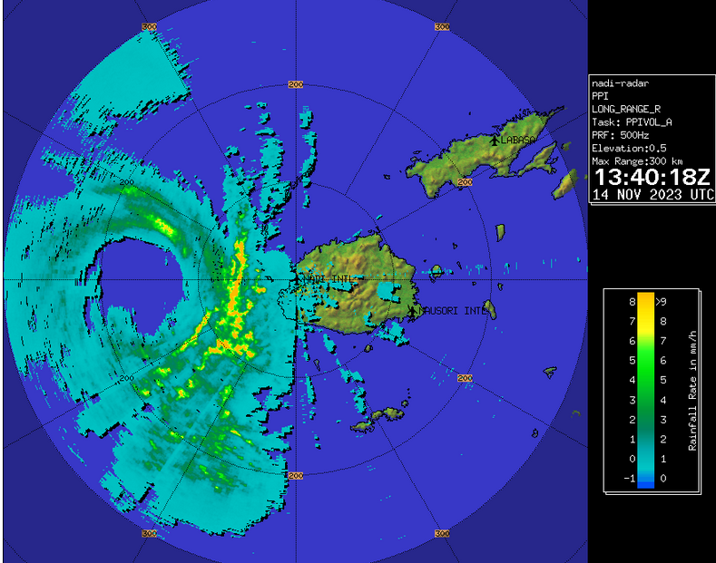
Radar from the Fiji Meteorological Service showed the center of Tropical Cyclone Mal passing just to the west of Viti Levu on Tuesday morning. A weather station at the airport in Nadi (NFFN) reported a sustained wind speed of 41 m.p.h. (66 km/h) and a wind gust of 63 m.p.h. (102 km/h).

Tropical Cyclone Mal was the equivalent of a hurricane/typhoon when it passed just to the west of Fiji on Tuesday morning. A circular eye with a diameter of 50 miles (80 km) was at the center of Mal’s circulation. The eye was surrounded by a ring of thunderstorms and the strongest winds were occurring in that ring of storms. Bands of showers and thunderstorms were revolving around the core of Tropical Cyclone Mal. Storms near the core generated upper level divergence that pumped mass away to the southeast of the tropical cyclone.

Winds to hurricane/typhoon force extended out 40 miles (65 km) from the center of Tropical Cyclone Mal. Winds to tropical storm force extended out 155 miles (250 km) from the center of Mal’s circulation.

Tropical Cyclone Mal will move into an environment that will become unfavorable for intensification during the next 24 hours. Mal will move over water where the Sea Surface Temperatures are near 26°C. It will move under the eastern side of an upper level trough over the Coral Sea. The upper level trough will produce northwesterly winds that will blow toward the top of Mal’s circulation. Those winds will cause moderate vertical wind shear. The combination of cooler water and moderate vertical wind shear will cause Tropical Cyclone Mal to start to weaken during the next 24 hours.

The upper level trough over the Coral Sea will steer Tropical Cyclone Mal toward the south-southeast during the next 24 hours. On its anticipated track, Tropical Cyclone Mal will move south of Fiji.

The eastern side of the eyewall of Tropical Cyclone Mal could pass close to the west coast of Viti Levu. A rainband on the eastern side of Mal’s circulation could bring strong winds and heavy rain to the western part of Viti Levu. Scattered electricity outages are possible. Locally heavy rain could cause flash floods in some locations. Tropical Cyclone Mal could cause a storm surge of up to 7 feet (2 meters) along parts of the northern and western coasts of Viti Levu. Mal could also bring gusty winds and heavy rain to Kadavu and Ono.

Tropical Cyclone Mal Intensifies to Equivalent of a Hurricane/Typhoon

Tropical Cyclone Mal intensified to the equivalent of a hurricane/typhoon over the South Pacific Ocean northwest of Fiji on Monday. At 10:00 p.m. EST on Monday the center of Tropical Cyclone Mal was located at latitude 15.3°S and longitude 175.1°E which put it about 225 miles (365 km) northwest of Nadi, Fiji. Mal was moving toward the south-southeast at 16 m.p.h. (26 km/h). The maximum sustained wind speed was 75 m.p.h. (120 km/h) and there were wind gusts to 90 m.p.h. (145 km/h). The minimum surface pressure was 984 mb.

Tropical Cyclone Mal rapidly intensified to the equivalent of a hurricane/typhoon northwest of Fiji on Monday. The inner end of a rainband wrapped around the center of Mal’s circulation. Microwave satellite images suggested that an eye was forming at the center of Tropical Cyclone Mal. Bands of showers and thunderstorms were revolving around the core of Mal’s circulation. Storms near the core generated upper level divergence that pumped mass away to the southeast of the tropical cyclone.

Winds to hurricane/typhoon force extended out 20 miles (30 km) from the center of Tropical Cyclone Mal. Winds to tropical storm force extended out 155 miles (250 km) from the center of Mal’s circulation.

Tropical Cyclone Mal will move through an environment favorable for intensification during the next 18 hours. Mal will move over water where the Sea Surface Temperatures are near 28°C. It will move under the western part of an upper level ridge over the South Pacific Ocean. The upper level ridge will produce northerly winds that will blow toward the top of Mal’s circulation. Those winds will cause vertical wind shear, but the wind shear will not be strong enough to prevent intensification. Tropical Cyclone Mal is likely to intensify during the next 18 hours.

Tropical Cyclone Mal will move around the southwestern part of a high pressure system over the South Pacific Ocean. The high pressure system will steer Mal toward the southeast during the next 24 hours. On its anticipated track, Tropical Cyclone Mal will pass just to the west of Viti Levu in 12 to 18 hours.

Tropical Cyclone Mal will bring strong winds and locally heavy rain to Fiji. The strongest winds and heaviest rain will affect Viti Levu. Heavy rain could cause flash floods in some locations. Scattered outages of electricity are possible. Tropical Cyclone Mal could cause a storm surge of up to 7 feet (2 meters) along the north and west coasts of Viti Levu.

Tropical Cyclone Mal Forms Northwest of Fiji

Tropical Cyclone Mal formed over the South Pacific Ocean northwest of Fiji on Sunday night. At 4:00 a.m. EST on Monday the center of Tropical Cyclone Mal was located at latitude 11.9°S and longitude 172.3°E which put it about 520 miles (840 km) northwest of Nadi, Fiji. Mal was moving toward the southeast at 21 m.p.h. (33 km/h). The maximum sustained wind speed was 50 m.p.h. (80 km/h) and there were wind gusts to 65 m.p.h. (105 km/h). The minimum surface pressure was 994 mb.

A low pressure system over the South Pacific Ocean northwest of Fiji strengthened during Sunday night and the Fiji Meteorological Service designated the system as Tropical Cyclone Mal. The circulation around Tropical Cyclone Mal exhibited more organization on Monday morning. More thunderstorms developed near the center of Mal’s circulation. Bands of showers and thunderstorms were revolving around the center of circulation. Storms near the center of circulation generated upper level divergence that pumped mass away to the southeast of the tropical cyclone. Winds to tropical storm force extended out 150 miles (240 km) from the center of Tropical Cyclone Mal.

Tropical Cyclone Mal will move through an environment favorable for intensification during the next 24 hours. Mal will move over water where the Sea Surface Temperatures are near 28°C. It will move under the western part of an upper level ridge over the South Pacific Ocean. The upper level ridge will produce northerly winds that will blow toward the top of Mal’s circulation. Those winds will cause vertical wind shear, but the wind shear will not be strong enough to prevent intensification. Tropical Cyclone Mal will intensify during the next 24 hours. Mal could strengthen to the equivalent of a hurricane/typhoon.

Tropical Cyclone Mal will move around the southwestern part of a high pressure system over the South Pacific Ocean. The high pressure system will steer Mal toward the southeast during the next 24 hours. On its anticipated track, Tropical Cyclone Mal will approach Fiji in 24 hours.

Tropical Cyclone Mal will bring strong winds and locally heavy rain to Fiji. Heavy rain could cause flash floods in some locations.