Tag Archives: Kadavu

Tropical Cyclone Mal Passes West of Fiji

The center of Tropical Cyclone Mal passed just to the west of Fiji on Tuesday morning. At 10:00 a.m. EST on Tuesday the center of Tropical Cyclone Mal was located at latitude 17.8°S and longitude 175.9°E which put it about 125 miles (200 km) west of Nadi, Fiji. Mal was moving toward the south-southeast at 14 m.p.h. (22 km/h). The maximum sustained wind speed was 75 m.p.h. (120 km/h) and there were wind gusts to 90 m.p.h. (145 km/h). The minimum surface pressure was 983 mb.

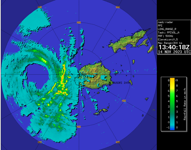
Radar from the Fiji Meteorological Service showed the center of Tropical Cyclone Mal passing just to the west of Viti Levu on Tuesday morning. A weather station at the airport in Nadi (NFFN) reported a sustained wind speed of 41 m.p.h. (66 km/h) and a wind gust of 63 m.p.h. (102 km/h).

Tropical Cyclone Mal was the equivalent of a hurricane/typhoon when it passed just to the west of Fiji on Tuesday morning. A circular eye with a diameter of 50 miles (80 km) was at the center of Mal’s circulation. The eye was surrounded by a ring of thunderstorms and the strongest winds were occurring in that ring of storms. Bands of showers and thunderstorms were revolving around the core of Tropical Cyclone Mal. Storms near the core generated upper level divergence that pumped mass away to the southeast of the tropical cyclone.

Winds to hurricane/typhoon force extended out 40 miles (65 km) from the center of Tropical Cyclone Mal. Winds to tropical storm force extended out 155 miles (250 km) from the center of Mal’s circulation.

Tropical Cyclone Mal will move into an environment that will become unfavorable for intensification during the next 24 hours. Mal will move over water where the Sea Surface Temperatures are near 26°C. It will move under the eastern side of an upper level trough over the Coral Sea. The upper level trough will produce northwesterly winds that will blow toward the top of Mal’s circulation. Those winds will cause moderate vertical wind shear. The combination of cooler water and moderate vertical wind shear will cause Tropical Cyclone Mal to start to weaken during the next 24 hours.

The upper level trough over the Coral Sea will steer Tropical Cyclone Mal toward the south-southeast during the next 24 hours. On its anticipated track, Tropical Cyclone Mal will move south of Fiji.

The eastern side of the eyewall of Tropical Cyclone Mal could pass close to the west coast of Viti Levu. A rainband on the eastern side of Mal’s circulation could bring strong winds and heavy rain to the western part of Viti Levu. Scattered electricity outages are possible. Locally heavy rain could cause flash floods in some locations. Tropical Cyclone Mal could cause a storm surge of up to 7 feet (2 meters) along parts of the northern and western coasts of Viti Levu. Mal could also bring gusty winds and heavy rain to Kadavu and Ono.

Tropical Cyclone Ana Brings Wind and Rain to Fiji

Tropical Cyclone Ana brought wind and rain to Fiji on Saturday. At 4:00 p.m. EST on Saturday the center of Tropical Cyclone Ana was located at latitude 17.8°S and longitude 178.3°E which put it about 45 miles (75 km) north-northwest of Suva, Fiji. Ana was moving toward the southeast at 10 m.p.h. (16 km/h). The maximum sustained wind speed was 70 m.p.h. (110 km/h) and there were wind gusts to 85 m.p.h. (135 km/h). The minimum surface pressure was 974 mb.

Tropical Cyclone Ana made landfall on the north coast of Viti Levu near Rakiraki on Saturday afternoon. Ana had strengthened to nearly the equivalent of a hurricane/typhoon by the time it made landfall. Radar images from the Fiji Meteorological Service indicated that an eye was beginning to form at the center of Tropical Cyclone Ana before it made landfall. A ring of strong thunderstorms surrounded the forming eye and the strongest winds were occurring in that ring of storms. Bands of showers and thunderstorms were revolving around the center of Ana. Winds to tropical storm force extended out 200 miles (320 km) from the center of circulation.

Tropical Cyclone Ana was producing winds to tropical storm force on Viti Levu and Vanua Levu. Heavy rain was also falling on those islands and flash floods could occur. Gusty winds and heavy rain will spread over Kadavu on Sunday.

An upper level trough east of Australia will produce northwesterly winds which will steer Tropical Cyclone Ana toward the southeast during the next 24 hours. On it anticipated track the center of Ana will cross eastern Viti Levu during the next 12 hours. Tropical Cyclone Ana will pass near Kadavu on Sunday. Ana is expected to pass west of Tonga early next week.

Powerful Tropical Cyclone Harold Brings Wind and Rain to Fiji

Powerful Tropical Cyclone Harold brought strong wind and heavy rain to parts of Fiji on Tuesday night.  At 11:00 p.m. EDT on Tuesday the center of Tropical Cyclone Harold was located at latitude 19.4°S and longitude 178.7°E which put it about 30 miles (50 km) southeast of Tavuki, Fiji.  Harold was moving toward the east-southeast at 22 m.p.h (35 km/h).  The maximum sustained wind speed was 140 m.p.h. (225 km/h) and there were wind gusts to 165 m.p.h. (270 km/h).  The minimum surface pressure was 930 mb.

The eye of Tropical Cyclone Harold passed directly over Kadavu Island, Fiji on Tuesday night.  The Hurricane Intensity Index (HII) for Harold was 28.3.  The Hurricane Size Index (HSI) was 19.7 and the Hurricane Wind Intensity Size Index (HWISI) was 48.0.  Tropical Cyclone Harold probably caused significant damage to Kadavu.  Harold also brought gusty winds and heavy rain to Viti Levu.  Flash floods were likely to have occurred in areas that received heavy rain.

Tropical Cyclone Harold strengthened on Tuesday after it moved away from Vanuatu where it caused significant damage.  The eye became evident on satellite imagery again and a solid ring of thunderstorms formed a strong eyewall.  The strongest winds were occurring in that ring of storms.  Storms around the core of Harold generated strong upper level divergence which pumped mass away from the tropical cyclone.  The size of the circulation around Tropical Cyclone Harold continued to increase in size.  Winds to hurricane/typhoon force extended out 65 miles (105 km) from the center of circulation.  Winds to tropical storm force extended out 250 miles (400 km) from the center.

Tropical Cyclone Harold will move into an area less favorable for intensification during the next 24 hours.  Harold will move over water where the Sea Surface Temperature is near 28°C.  It will move under the southwestern part of an upper level ridge over the South Pacific Ocean.  The ridge will produce northwesterly winds which will blow toward the top of the circulation.  Those winds will increase in speed during the next 48 hours and the increased vertical wind shear will cause Tropical Cyclone Harold to weaken.  Harold could weaken slowly during the next 12 to 24 hours.

Tropical Cyclone Harold will move around the southwestern part of a high pressure system over the South Pacific Ocean.  The high will steer Harold quickly toward the east-southeast.  On its anticipated track the center of Tropical Cyclone Harold could reach Tonga within 12 to 18 hours.  Harold will be the equivalent of a major hurricane when it reaches Tonga.

Tropical Cyclone Sarai Moves Across Southern Fiji

Tropical Cyclone Sarai moved across southern parts of Fiji on Saturday.  At 10:00 p.m. EST on Saturday the center of Tropical Cyclone Sarai was located at latitude 19.9°S and longitude 179.1°E which put it about 30 miles (50 km) southwest of Matuku, Fiji.  Sarai was moving toward the east at 7 m.p.h. (11 km/h).  The maximum sustained wind speed was 80 m.p.h. (130 km/h) and there were wind gusts to 95 m.p.h. (155 km/h).  The minimum surface pressure was 976 mb.

Tropical Cyclone Sarai strengthened into the equivalent of a hurricane/typhoon on Saturday as it moved across the southern part of Fiji.  The center of Sarai passed south of Kadavu, but raindbands on the northern side of the circulation brought gusty winds and heavy rain to the island.  A ragged eye appeared intermittently on satellite images.  The eye was surrounded by a broken ring of thunderstorms and the strongest winds were occurring in that ring of storms.  Tropical Cyclone Sarai had a large circulation.  Winds to hurricane/typhoon force extended out 60 miles (95 km) from the center of circulation.  Winds to tropical storm force extended out 200 miles (320 km) from the center.

Tropical Cyclone Sarai will move into an environment that will become increasingly unfavorable for intensification.  Sarai will move over water where the Sea Surface Temperature is near 28°C.  So, there will be enough energy in the upper ocean to support a strong tropical cyclone.  Tropical Cyclone Sarai will move south of an upper level ridge.  The ridge will produce westerly winds which will get stronger during the next several days.  Those winds will cause moderate vertical wind shear.  When the shear gets stronger, Tropical Cyclone Sarai will start to weaken.

Tropical Cyclone Sarai will move south of a subtropical high pressure system over the South Pacific Ocean.  The high will steer Sarai toward the east during the next 48 hours.  On its anticipated track Tropical Cyclone Sarai will move across Matuku, Fiji during the next few hours.  Sarai will reach the Lau Group of Fiji Islands during the next 24 hours.  Tropical Cyclone Sarai could reach parts of Tonga within 48 hours.  Sarai will bring gusty winds and heavy rain to all of those places during the next 48 hours.

Tropical Cyclone Sarai Brings Wind and Rain to Fiji

Tropical Cyclone Sarai brought wind and rain to Fiji in Friday.  At 4:00 p.m. EST on Friday the center of Tropical Cyclone Sarai was located at latitude 19.3°S and longitude 177.0°E which put it about 100 miles (160 km) west-southwest of Kadavu, Fiji.  Sarai was moving toward the southeast at 12 m.p.h. (19 km/h).  The maximum sustained wind speed was 70 m.p.h. (110 km/h) and there were wind gusts to 85 m.p.h. (135 km/h).  The minimum surface pressure was 983 mb.

The center of Tropical Cyclone Sarai passed west of Nadi, Fiji on Friday, but rainbands in the eastern side of the circulation produced gusty winds and heavy rain.  A surface weather station in Nadi measured a sustained wind speed of 44 m.p.h. (70 km/h) and wind gusts of 67 m.p.h. (107 km/h).

Tropical Cyclone Sarai continued to intensify on Friday.  The inner end of a rainband wrapped much of the way around the center of circulation.  The rainband had not wrapped entirely around the northwestern part of the center,  A clear area at the center began to appear on satellite images, which could be evidence of formation of an eye.  Storms around the center were generating upper level divergence which was pumping mass away to the east of the tropical cyclone.  The circulation around Tropical Cyclone Sarai was large.  Winds to tropical storm force extended out 200 miles (320 km) from the center of Sarai.

Tropical Cyclone Sarai will move through an environment favorable for intensification for another 24 to 36 hours.  Sarai will move over water where the Sea Surface Temperature is near 28°C.  It will move south of an upper level ridge.  The ridge will produce westerly winds which will blow toward the top of the circulation.  Those winds will cause moderate vertical wind shear.  The wind shear will inhibit intensification, but it will not be strong enough to keep Tropical Cyclone Sarai from strengthening into the equivalent of a hurricane/typhoon.

Tropical Cyclone Sarai will move south of a subtropical high pressure system over the South Pacific Ocean.  The ridge will steer Sarai toward the east.  On its anticipated track the center of Tropical Cyclone Sarai will pass south of Suva, Fiji.  The core of Sarai will pass near Kadavu, Fiji in about 12 to 18 hours.  Tropical Cyclone Sarai will bring gusty winds and locally heavy rain to Kadavu.  Heavy rain could cause flash floods in some locations.