Monthly Archives: June 2024

Hurricane Beryl Strengthens to Cat. 4

Hurricane Beryl strengthened to Category 4 on the Saffir-Simpson Scale on Sunday morning.  At 11:30 a.m. EDT on Sunday the center of Hurricane Beryl was located at latitude 10.8°N and longitude 54.9°W which put the center about 350 miles (565 km) east-southeast of Barbados.   Beryl was moving toward the west at 21 m.p.h. (33 km/h).   The maximum sustained wind speed was 130 m.p.h. (210 km/h) and there were wind gusts to 160 m.p.h. (260 km/h).   The minimum surface pressure was 962 mb.

Hurricane Warnings were in effect for Barbados, St. Lucia, Grenada, Tobago, and St. Vincent and the Grenadine Islands.

A Tropical Storm Warning was in effect for Martinique.

Tropical Storm Watches were in effect for Dominica and Trinidad.

A U.S. Air Force Reserve Hurricane Hunter aircraft found that Hurricane Beryl had rapidly intensified on Sunday morning to Category 4 on the Saffir-Simpson Scale.

A circular eye with a diameter of 18 miles (30 km) was present at the center of Beryl’s circulation.  The eye was surrounded by a ring of thunderstorms and the strongest winds were occurring in that ring of storms.  Bands of showers and thunderstorms were revolving around the core of Hurricane Beryl.  Storms near the core generated strong upper level divergence that pumped mass away from the hurricane in all directions.  The removal of large amounts of mass caused the surface pressure to decrease rapidly.

The reconnaissance aircraft also found that the size of the circulation around Hurricane Beryl increased when Beryl rapidly intensified.  Winds to hurricane force extended out 30 miles (50 km) from the center of Beryl’s circulation.  Winds to tropical storm force extended out 115 miles (185 km) from the center of Hurricane Beryl.

Hurricane Beryl will move through an environment favorable for intensification during the next 24 hours.  Beryl will move over water where the Sea Surface Temperatures are near 29°C.  It will move under the southern part of an upper level ridge over the central tropical Atlantic Ocean.  The ridge will produce easterly winds that will blow toward the top of Beryl’s circulation.  The winds in the lower levels of the atmosphere are also blowing from the east and there will be little vertical wind shear.  Hurricane Beryl is likely to continue to intensify during the next 24 hours.  Beryl could continue to intensify rapidly during the next few hours.  There is a chance Hurricane Beryl could strengthen to Category 5 on the Saffir-Simpson Scale.

Hurricane Beryl will move around the southern side of a high pressure system over the Atlantic Ocean.  The high pressure system will steer Beryl toward the west during the next 24 hours.  On its anticipated track, Tropical Storm Beryl will move quickly toward the Windward Islands.  Beryl will approach Barbados and Tobago by Sunday night.  Hurricane Beryl will affect St. Lucia, Grenada, St. Vincent and the Grenadine Islands, and Martinique on Monday.

The core of Hurricane Beryl could pass very close to Grenada and St. Vincent and the Grenadine Islands.  Beryl will be capable of causing regional severe damage.  Hurricane Beryl will also drop heavy rain.  Heavy rain is likely to cause flash floods in some locations.  Hurricane Beryl could cause a storm surge of up to 13 feet (4 meters) on the parts of islands where the wind blows the water toward the shore.

Hurricane Beryl will also produce strong winds and heavy rain in Barbados, Tobago, St. Lucia and Martinique.  Gusty winds and heavy rain could occur in Trinidad and Dominica.


Beryl Rapidly Intensifies to a Major Hurricane

Hurricane Beryl rapidly intensified to a major hurricane over the Atlantic Ocean east of the Windward Islands on Sunday morning.  At 8:00 a.m. EDT on Sunday the center of Hurricane Beryl was located at latitude 10.6°N and longitude 53.9°W which put the center about 420 miles (675 km) east-southeast of Barbados.  Beryl was moving toward the west at 21 m.p.h. (33 km/h).  The maximum sustained wind speed was 115 m.p.h. (185 km/h) and there were wind gusts to 140 m.p.h. (225 km/h).  The minimum surface pressure was 968 mb.

Hurricane Warnings were in effect for Barbados, St. Lucia, Grenada, Tobago, and St. Vincent and the Grenadine Islands.

A Tropical Storm Warning was in effect for Martinique.

A Tropical Storm Watch was in effect for Dominica.

A U.S. Air Force Reserve Hurricane Hunter aircraft found that Hurricane Beryl had rapidly intensified to a major hurricane on Sunday morning.  Beryl was a Category 3 hurricane on the Saffir-Simpson Scale.

A circular eye with a diameter of 25 miles (40 km) formed at the center of Beryl’s circulation.  The eye was surrounded by a ring of thunderstorms and the strongest winds were occurring in that ring of storms.  Bands of showers and thunderstorms were revolving around the core of Hurricane Beryl.  Storms near the core generated strong upper level divergence that pumped mass away from the hurricane in all directions.  The removal of large amounts of mass caused the surface pressure to decrease rapidly.

The circulation around Hurricane Beryl was relatively small.  Winds to hurricane force extended out 20 miles (30 km) from the center of Beryl’s circulation.  Winds to tropical storm force extended out 80 miles (130 km) from the center of Hurricane Beryl.

The Hurricane Intensity Index (HII) for Hurricane Beryl was 20.6.  The Hurricane Size Index (HSI) was 5.4.  The Hurricane Wind Intensity Size Index (HWISI) was 26.0.

Hurricane Beryl will move through an environment favorable for intensification during the next 24 hours.  Beryl will move over water where the Sea Surface Temperatures are near 29°C.  It will move under the southern part of an upper level ridge over the central tropical Atlantic Ocean.  The ridge will produce easterly winds that will blow toward the top of Beryl’s circulation.  The winds in the lower levels of the atmosphere are also blowing from the east and there will be little vertical wind shear.  Hurricane Beryl will continue to intensify during the next 24 hours. Beryl could continue to intensify rapidly.

Hurricane Beryl will move around the southern side of a high pressure system over the Atlantic Ocean.  The high pressure system will steer Beryl toward the west during the next 24 hours.  On its anticipated track, Tropical Storm Beryl will move quickly toward the Windward Islands.  Beryl will approach Barbados and Tobago by Sunday night.  Hurricane Beryl will affect St. Lucia, Grenada, St. Vincent and the Grenadine Islands, and Martinique on Monday.

Hurricane Beryl will be a major hurricane when it reaches the Windward Islands.  Beryl will cause major damage on some of the Windward Islands.  Hurricane Beryl will also drop heavy rain.  Heavy rain is likely to cause flash floods in some locations.  Hurricane Beryl could cause a storm surge of up to 13 feet (4 meters) on the parts of islands where the wind blows the water toward the shore.


Beryl Rapidly Intensifies to a Hurricane

Former Tropical Storm Beryl rapidly intensified to a hurricane over the Atlantic Ocean east of the Lesser Antilles on Saturday.  At 5:00 p.m. EDT on Saturday the center of Hurricane Beryl was located at latitude 10.1°N and longitude 49.3°W which put the center about 720 miles (1160 km) east-southeast of Barbados.  Beryl was moving toward the west at 22 m.p.h. (35 km/h).  The maximum sustained wind speed was 75 m.p.h. (120 km/h) and there were wind gusts to 90 m.p.h. (145 km/h).  The minimum surface pressure was 992 mb.

A Hurricane Warning was in effect for Barbados.

Hurricane Watches were in effect for St. Lucia, Grenada, and St. Vincent and the Grenadine Islands.

Tropical Storm Watches were in effect for Martinique, Dominica, and Tobago.

Former Tropical Storm Beryl rapidly intensified to a hurricane on Saturday.  The inner end of a rainband wrapped around the center of Beryl’s circulation.  A small circular eye was at the center of Hurricane Beryl on microwave satellite images.  The eye was surrounded by a ring of thunderstorms and the strongest winds were occurring in that ring of storms.  Bands of showers and thunderstorms were revolving around the center of Beryl’s circulation.  Storms near the center of circulation generated upper level divergence that pumped mass away form the hurricane.  The removal of mass caused the surface pressure to decrease rapidly.

The circulation around Hurricane Beryl was relatively small.  Winds to hurricane force extended out 15 miles in the northeastern quadrant of Beryl’s circulation.  Winds to tropical storm force extended out 60 miles (95 km) from the center of Hurricane Beryl.

Hurricane Beryl will move through an environment favorable for intensification during the next 24 hours.  Beryl will move over water where the Sea Surface Temperatures are near 29°C.  It will move under the southern part of an upper level ridge over the central tropical Atlantic Ocean.  The ridge will produce easterly winds that will blow toward the top of Beryl’s circulation.  The winds in the lower levels of the atmosphere are also blowing from the east and there will be little vertical wind shear.  Hurricane Beryl will continue to intensify during the next 24 hours. Beryl could continue to intensify rapidly.  Beryl could intensify to a major hurricane before it reaches the Lesser Antilles.

Hurricane Beryl will move around the southern side of a high pressure system over the Atlantic Ocean.  The high pressure system will steer Beryl toward the west during the next 24 hours.  On its anticipated track, Tropical Storm Beryl will move quickly toward the Lesser Antilles.  Beryl could approach Barbados by Sunday night.

Hurricane Beryl could be a major hurricane by the time it reaches the Windward Islands.  Beryl could cause major damage on some of the Windward Islands.  Hurricane Beryl will also drop heavy rain.  Heavy rain is likely to cause flash floods in some locations.  Hurricane Beryl could cause a storm surge of up to 13 feet (4 meters).


Tropical Storm Beryl Prompts Hurricane Watch for Barbados

The risk posed by Tropical Storm Beryl prompted the issuance of a Hurricane Watch for Barbados on Saturday.  At 8:00 a.m. EDT on Saturday the center of Tropical Storm Beryl was located at latitude 9.8°N and longitude 46.8°W which put the center about 890 miles (1435 km) east-southeast of Barbados.  Beryl was moving toward the west at 21 m.p.h. (33 km/h).  The maximum sustained wind speed was 60 m.p.h. (95 km/h) and there were wind gusts to 75 m.p.h. (120 km/h).  The minimum surface pressure was 999 mb.

A Hurricane Watch was in effect for Barbados.

Tropical Storm Beryl strengthened rapidly during Friday night as it moved closer to the Lesser Antilles.  The inner end of a rainband wrapped around the center of Beryl’s circulation.  Other bands of showers and thunderstorms were revolving around around the center of Tropical Storm Beryl.  Storms near the center of circulation generated upper level divergence that pumped mass away from the tropical storm.  The removal of more mass cause the surface pressure to decrease more rapidly.

Winds to tropical storm force extended out 45 miles (75 km) from the center of of Tropical Storm Beryl.

Tropical Storm Beryl will move through an environment favorable for intensification during the next 24 hours.  Beryl will move over water where the Sea Surface Temperatures are near 28°C.  It will move under the axis of an upper level ridge over the central tropical Atlantic Ocean.  The upper level winds are weak near the axis of the ridge and there will be little vertical wind shear.  Tropical Storm Beryl will continue to intensify during the next 24 hours.  Beryl will strengthen to a hurricane.  Tropical Storm Beryl could continue to intensify rapidly.  Beryl could intensify to a major hurricane before it reaches the Lesser Antilles.

Tropical Storm Beryl will move around the southern side of a high pressure system over the Atlantic Ocean. T he high pressure system will steer Beryl toward the west during the next 24 hours.  On its anticipated track, Tropical Storm Beryl will move quickly toward the Lesser Antilles.  Beryl could approach Barbados on Sunday night.

Tropical Storm Beryl will be a hurricane by the time it reaches the Lesser Antilles.  Additional Tropical Storm and Hurricane Watches are likely to be issued for the Windward Islands on Saturday.  Beryl could cause major damage on some of the Windward Islands.

Depression Strengthens to Tropical Storm Beryl

Former Tropical Depression Two strengthened to Tropical Storm Beryl on Friday evening.  At 11:00 p.m. EDT on Friday the center of Tropical Storm Beryl was located at latitude 9.3°N and longitude 43.6°W which put the center about 1110 miles (1785 km) east-southeast of Barbados. Beryl was moving toward the west at 18 m.p.h. (30 km/h).  The maximum sustained wind speed was 40 m.p.h. (65 km/h) and there were wind gusts to 50 m.p.h. (80 km/h).  The minimum surface pressure was 1006 mb.

Former Tropical Depression Two strengthened on Friday evening and the U.S. National Hurricane Center designated the system as Tropical Storm Beryl.  Thunderstorms just to the west of the center of Tropical Storm Beryl rose higher into the atmosphere.  Bands of showers and thunderstorms were revolving around the center of Beryl’s circulation.  Storms near the center of circulation generated upper level divergence that pumped mass away from the tropical storm.  The removal of mass caused the surface pressure to start to decrease.

Winds to tropical storm force extended out 45 miles (75 km) in the northern half of Tropical Storm Beryl.  The winds in the southern half of Beryl’s circulation were blowing at less than tropical storm force.

Tropical Storm Beryl will move through an environment favorable for intensification during the next 24 hours.  Beryl will move over water where the Sea Surface Temperatures are near 28°C.  It will move under the axis of an upper level ridge over the central tropical Atlantic Ocean.  The upper level winds are weak near the axis of the ridge and there will be little vertical wind shear.  Tropical Storm Beryl will continue to intensify during the next 24 hours.  Beryl could strengthen to a hurricane during the weekend.

Tropical Storm Beryl will move around the southern side of a high pressure system over the Atlantic Ocean.  The high pressure system will steer Beryl toward the west during the next 24 hours.  On its anticipated track, Tropical Storm Beryl will move toward the Lesser Antilles.

Tropical Storm Beryl could be a hurricane by the time it reaches the Lesser Antilles.  Tropical Storm and Hurricane Watches are likely to be issued for the Windward Islands on Saturday.

Tropical Depression Two Forms East of Lesser Antilles

Tropical Depression Two formed over the Atlantic Ocean east of the Lesser Antilles on Friday.  At 5:00 p.m. EDT on Friday the center of Tropical Depression Two located at latitude 9.1°N and longitude 41.9°W which put the center about 1225 miles (1970 km) east-southeast of Barbados.  The tropical depression was moving toward the west at 17 m.p.h. (28 km/h).  The maximum sustained wind speed was 35 m.p.h. (55 km/h) and there were wind gusts to 45 m.p.h. (75 km/h).  The minimum surface pressure was 1007 mb.

A tropical wave, formerly designated as Invest 95L, exhibited more organization on Friday afternoon and the U.S. National Hurricane Center designated the system as Tropical Depression Two.  Visible satellite images appeared to indicated that a distinct low level center of circulation was present in Tropical Depression Two.  Bands of showers and thunderstorms were revolving around the apparent center of circulation.  Storms near the center generated upper level divergence that pumped mass away from the tropical depression.

Tropical Depression Two will move through an environment favorable for intensification during the next 24 hours.  The tropical depression will move over water where the Sea Surface Temperatures are near 28°C.  It will move under the axis of an upper level ridge over the central tropical Atlantic Ocean.  The upper level winds are weak near the axis of the ridge and there will be little vertical wind shear.  Tropical Depression Two is very likely to intensify to a tropical storm during the next 24 hours.  It could strengthen to a hurricane during the weekend.

Tropical Depression Two will move around the southern side of a high pressure system over the Atlantic Ocean.  The high pressure system will steer the tropical depression toward the west during the next 24 hours.  On its anticipated track, Tropical Depression Two will move toward the Lesser Antilles.

Tropical Depression Two could be a hurricane by the time it reaches the Lesser Antilles.  Tropical Storm and Hurricane Watches are likely to be issued for the Windward Islands either Friday night or Saturday morning.


Tropical Cyclone Likely to Form East of Lesser Antilles

A tropical cyclone is likely to form over the Atlantic Ocean east of the Lesser Antilles during the next few days.  The tropical cyclone is likely to develop from a tropical wave currently designated as Invest 95L.  At 2:00 p.m. EDT on Thursday the center of the tropical wave located at latitude 9.7°N and longitude 35.4°W which put the center about 1720 miles (2775 km) east of the Lesser Antilles.  The tropical wave was moving toward the west at 15 m.p.h. (24 km/h).  The maximum sustained wind speed was 30 m.p.h. (50 km/h) and there were wind gusts to 40 m.p.h. (65 km/h).  The minimum surface pressure was 1009 mb.

A tropical cyclone is likely to form east of the Lesser Antilles from a tropical wave currently designated as Invest 95L.  The structure of Invest 95L exhibited more organization on satellite imagery on Thursday afternoon.  Bands of showers and thunderstorms were beginning to revolve around a possible center of circulation.  Storms in those bands began to generate upper level divergence that was pumping mass away from the tropical wave.

The tropical wave designated as Invest 95L will move through an environment favorable for the formation of a tropical cyclone during the next 48 hours.  The tropical wave will will move over water where the Sea Surface Temperatures are near 28°C.  Invest 95L will move under the axis of an upper level ridge over the eastern tropical Atlantic Ocean.  The upper level winds are weak near the axis of the ridge and there will be little vertical wind shear.  The U.S. National Hurricane Center is indicating the probability is 80% that the tropical wave designated as Invest 95L develops into a tropical cyclone.

The tropical wave designated as Invest 95L will move around the southern side of a high pressure system over the Atlantic Ocean.  The high pressure system will steer the tropical wave toward the west during the next several days.  On its anticipated track, Invest 95L could approach the Lesser Antilles by the end of the weekend.  Invest 95L could strengthen to a hurricane by the time it approaches the Lesser Antilles.

Elsewhere, a tropical wave designated as Invest 94L was over the Northwest Caribbean Sea.  The U.S. National Hurricane Center was indicating the probability was 30% that Invest 94L develops into a tropical cyclone.  At 2:00 p.m. EDT on Thursday the center of that tropical wave located at latitude 15.4°N and longitude 83.3°W which put the center about 35 miles (55 km) north of Cabo Gracias a Dios.  Invest 94L was moving toward the west-northwest at 15 m.p.h. (24 km/h).  The maximum sustained wind speed was 30 m.p.h. (50 km/h) and there were wind gusts to 40 m.p.h. (65 km/h).  The minimum surface pressure was 1008 mb.

Fast Moving Tropical Wave Over Eastern Caribbean Sea

A fast moving tropical wave was over the eastern Caribbean Sea on Tuesday afternoon.  The wave has been designated as Invest 94L.  At 2:00 p.m. EDT on Tuesday the center of the tropical wave located at latitude 12.2°N and longitude 65.7°W which put the center about 170 miles (275 km) east of Bonaire.  The tropical wave was moving toward the west at 25 m.p.h. (40 km/h).  The maximum sustained wind speed was 30 m.p.h. (50 km/h) and there were wind gusts to 40 m.p.h. (65 km/h).  The minimum surface pressure was 1010 mb.

A tropical wave moving rapidly over the eastern Caribbean Sea was designated as Invest 94L on Tuesday afternoon.  The tropical wave did not have a well defined low level center of circulation.  There did appear to be an area of rotation in the middle troposphere that was associated with the tropical wave.  Lines of showers and thunderstorms were moving toward the west with the tropical wave.

The tropical wave designated as Invest 94L will move south of a high pressure system over the western Atlantic Ocean.  The high pressure system will steer the tropical wave quickly toward the west during the next 24 hours.  On its anticipated track, Invest 94L will pass over Bonaire, Curacao and Aruba during the next 24 hours.  The tropical wave will bring thunderstorms and gusty winds to Bonaire, Curacao and Aruba.

The tropical wave designated as Invest 94L will move through an environment unfavorable for intensification during the next 24 hours.  The tropical wave will move over water where the Sea Surface Temperatures are near 29°C.  Invest 94L will move under the southern part of an upper level ridge over the Caribbean Sea.  The upper level ridge will produce easterly winds that will blow toward the top of the tropical wave.  Stronger easterly winds will blow in the lower levels of the atmosphere.  The difference in wind speed between the upper and lower levels will cause moderate vertical wind shear.  The wind shear will inhibit the formation of a tropical cyclone during the next 24 hours.

Invest 94L will move into an area where the lower level winds will be weaker when it reaches the western Caribbean Sea later this week.  The vertical wind shear is likely to decrease when the tropical wave is over the western Caribbean Sea.  The tropical wave could develop into a tropical cyclone later this week.  The U.S. National Hurricane Center is indicating the probability is 20% that the tropical wave develops into a tropical cyclone when it reaches the western Caribbean Sea.

Low Pressure System Drops Heavy Rain Near Georgia Coast

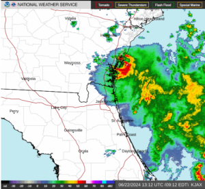
A low pressure system designated as Invest 92L was dropping heavy rain near the coast of Georgia on Saturday morning.  At 8:00 a.m. EDT on Saturday the center of the low pressure system was located at latitude 31.1°N and longitude 81.5°W which put the center about 5 miles (10 km) southeast of Brunswick, Georgia.  The low pressure system was moving toward the west-northwest at 5 m.p.h. (8 km/h).  The maximum sustained wind speed was 30 m.p.h. (50 km/h) and there were wind gusts to 40 m.p.h. (65 km/h).  The minimum surface pressure was 1015 mb.

A low pressure system designated as Invest 92L was dropping heavy rain near the coast of Georgia on Saturday morning.

The center of the low pressure system was near Brunswick, Georgia.  There was a well defined center of circulation evident on the U.S. National Weather Service radar at Jacksonville, Florida.  The center of circulation was moving slowly near the coast of Georgia.  The heaviest rain was falling in a ring that wrapped around the eastern side of the center of Invest 92L.  Other bands of rain were over the Atlantic Ocean.

The low pressure system is forecast to move slowly inland over eastern Georgia.  Heavy rain could fall over areas near the coast as Invest 92L moves inland.  Heavy rain could cause flooding in some locations.

Elsewhere, a large low pressure system formed over the southwestern Gulf of Mexico near the area where Tropical Storm Alberto formed.  The low pressure system has been designated as Invest 93L.  At 8:00 a.m. EDT on Saturday the center of Invest 93L was located at latitude 21.0°N and longitude 95.7°W which put it about 125 miles (200 km) east-southeast of Tampico, Mexico.  The low pressure system was moving toward the northwest at 13 m.p.h. (21 km/h).  The maximum sustained wind speed was 35 m.p.h. (55 km/h) and there were wind gusts to 45 m.p.h. (75 km/h).  The minimum surface pressure was 1005 mb.

Invest 93L will move through an environment somewhat favorable for the formation of a tropical cyclone during the next 24 hours.  Invest 93L will move over water where the Sea Surface Temperatures are near 30°C.  It will move under the southeastern part of an upper level ridge that stretches from Baja California to the Great Lakes.  The ridge will produce northeasterly winds that will blow toward the top of the low pressure system.  Those winds will cause moderate vertical wind shear.  The wind shear will inhibit intensification, but the shear may not be strong enough to prevent Invest 93L from developing into a tropical cyclone.  The U.S. National Hurricane Center is indicating that the probability is 50% that Invest 93L develops into a tropical cyclone.

The low pressure system designated as Invest 93L will move around the southern side of a large high pressure system over the eastern U.S.  The high pressure system will steer Invest 93L toward the west-northwest during the next 24 hours.  On its anticipated track, Invest 93L will approach the coast of Mexico near Tampico on Sunday.

The low pressure system designated as Invest 93L will drop heavy rain over some of the same areas where Tropical Storm Alberto dropped heavy rain.  Invest 93L is very likely to cause major flash floods in parts of northern Mexico.

A U.S. Air Force Reserve Hurricane Hunter aircraft is scheduled to investigate the low pressure system designated as Invest 93L later today, if necessary.

Low Pressure System Approaches Southeast U.S.

A small low pressure system was approaching the Southeast U.S. on Friday morning.  The low pressure system was officially designated as Invest 92L by the U.S. National Hurricane Center.  At 11:00 a.m. EDT on Friday the center of the low pressure system was located at latitude 30.4°N and longitude 79.5°W which put it about 135 miles (215 km) east of Jacksonville, Florida.  The low pressure system was moving toward the west-northwest at 15 m.p.h. (24 km/h).  The maximum sustained wind speed was 35 m.p.h. (55 km/h) and there were wind gusts to 45 m.p.h. (75 km/h).  The minimum surface pressure was 1014 mb.

The low pressure system approaching the Southeast U.S. was officially designated as Invest 92L, but it exhibited many of the characteristics of a tropical depression.  Thunderstorms were occurring near the center of the low pressure system.  Thunderstorms were also occurring in bands in the southern half of the circulation around Invest 92L.  Bands in the northern half of the circulation consisted primarily of showers and lower clouds, although there were also a few thunderstorms.  Storms near the center of circulation generated upper level divergence that pumped mass away to the southwest of the low pressure system.

The low pressure system approaching the Southeast U.S. will move through an environment somewhat favorable for intensification during the next few hours.  The low pressure system will move over water where the Sea Surface Temperatures are near 28°C.  It will move under the southeastern part of an upper level ridge that stretches from Texas to Maine.  The upper level ridge will produce northeasterly winds that will blow toward the top of the low pressure system.  The wind shear will inhibit intensification.  The low pressure system could strengthen a little, if the upper level winds do not get stronger.

The low pressure system will move around the southern side of a high pressure system that is over the western Atlantic Ocean and eastern U.S.  The high pressure system will steer Invest 92L toward the west-northwest during the next 24 hours.  On its anticipated track, the low pressure system will make landfall on the coast of Georgia later on Friday.

The low pressure system designated as Invest 92L will bring gusty winds and locally heavy rain to parts of northeastern Florida and eastern Georgia.  It will also generate waves and rip currents along the coast.  The waves could cause some minor coastal erosion.