Tag Archives: AL93

Low Pressure System Drops Heavy Rain Near Georgia Coast

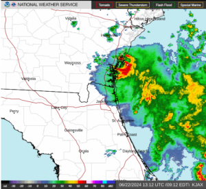
A low pressure system designated as Invest 92L was dropping heavy rain near the coast of Georgia on Saturday morning.  At 8:00 a.m. EDT on Saturday the center of the low pressure system was located at latitude 31.1°N and longitude 81.5°W which put the center about 5 miles (10 km) southeast of Brunswick, Georgia.  The low pressure system was moving toward the west-northwest at 5 m.p.h. (8 km/h).  The maximum sustained wind speed was 30 m.p.h. (50 km/h) and there were wind gusts to 40 m.p.h. (65 km/h).  The minimum surface pressure was 1015 mb.

A low pressure system designated as Invest 92L was dropping heavy rain near the coast of Georgia on Saturday morning.

The center of the low pressure system was near Brunswick, Georgia.  There was a well defined center of circulation evident on the U.S. National Weather Service radar at Jacksonville, Florida.  The center of circulation was moving slowly near the coast of Georgia.  The heaviest rain was falling in a ring that wrapped around the eastern side of the center of Invest 92L.  Other bands of rain were over the Atlantic Ocean.

The low pressure system is forecast to move slowly inland over eastern Georgia.  Heavy rain could fall over areas near the coast as Invest 92L moves inland.  Heavy rain could cause flooding in some locations.

Elsewhere, a large low pressure system formed over the southwestern Gulf of Mexico near the area where Tropical Storm Alberto formed.  The low pressure system has been designated as Invest 93L.  At 8:00 a.m. EDT on Saturday the center of Invest 93L was located at latitude 21.0°N and longitude 95.7°W which put it about 125 miles (200 km) east-southeast of Tampico, Mexico.  The low pressure system was moving toward the northwest at 13 m.p.h. (21 km/h).  The maximum sustained wind speed was 35 m.p.h. (55 km/h) and there were wind gusts to 45 m.p.h. (75 km/h).  The minimum surface pressure was 1005 mb.

Invest 93L will move through an environment somewhat favorable for the formation of a tropical cyclone during the next 24 hours.  Invest 93L will move over water where the Sea Surface Temperatures are near 30°C.  It will move under the southeastern part of an upper level ridge that stretches from Baja California to the Great Lakes.  The ridge will produce northeasterly winds that will blow toward the top of the low pressure system.  Those winds will cause moderate vertical wind shear.  The wind shear will inhibit intensification, but the shear may not be strong enough to prevent Invest 93L from developing into a tropical cyclone.  The U.S. National Hurricane Center is indicating that the probability is 50% that Invest 93L develops into a tropical cyclone.

The low pressure system designated as Invest 93L will move around the southern side of a large high pressure system over the eastern U.S.  The high pressure system will steer Invest 93L toward the west-northwest during the next 24 hours.  On its anticipated track, Invest 93L will approach the coast of Mexico near Tampico on Sunday.

The low pressure system designated as Invest 93L will drop heavy rain over some of the same areas where Tropical Storm Alberto dropped heavy rain.  Invest 93L is very likely to cause major flash floods in parts of northern Mexico.

A U.S. Air Force Reserve Hurricane Hunter aircraft is scheduled to investigate the low pressure system designated as Invest 93L later today, if necessary.

Possible Development over Southwest Caribbean Sea

A tropical depression or tropical storm could develop over the Southwestern Caribbean Sea east of Nicaragua during the next few days. An area of low pressure at the surface, currently designated as Invest 93L, is over that area. At 2:00 p.m. EDT on Tuesday the center of Invest 93L was located at latitude 11.8°N and longitude 82.2°W which put it about 110 miles (175 km) east of Bluefields, Nicaragua. Invest 93L was moving toward the west-northwest at 6 m.p.h. (10 km/h). The maximum sustained wind speed was 25 m.p.h. (40 km/h) and and there were wind gusts to 35 m.p.h. (55 km/h). The minimum surface pressure was 1009 mb.

Invest 93L was located on the eastern side of a larger area of low pressure that extends from the Southwestern Caribbean Sea across Central America to the Eastern North Pacific Ocean. A second, small low pressure system, currently designated as Invest 93E, was located over the Eastern North Pacific Ocean south of El Salvador. Visible satellite images appeared to show some counterclockwise rotation of lower clouds over the Southwestern Caribbean Sea east of Nicaragua. A few thunderstorms formed near the apparent center of circulation, but the system did not possess enough organization to be classified as a tropical depression.

Invest 93L will be in an environment that is somewhat favorable for the formation of a tropical cyclone during the next few days. Invest 93L will move over water where the Sea Surface Temperatures are near 29˚C. It will move through a region where the upper level winds are weak and there will be little vertical wind shear. If Invest 93L remains over the Southwest Caribbean Sea, it could develop into a tropical depression during the next 48 hours. However, if the center of Invest 93L moves inland over Nicaragua, then it will not develop. The National Hurricane Center is indicating there is a probability of 40% that Invest 93L develops into a tropical cyclone. A reconnaissance plane has been tentatively tasked to investigate Invest 93L on Wednesday afternoon, if necessary.

Invest 93L will move near the southwestern part of a high pressure system that extends from the Western Atlantic Ocean over the Caribbean Sea and the Gulf of Mexico. The steering winds are weak near the southwestern part of the high pressure system, but those winds could steer Invest 93L slowly toward the northwest during the next few days. On its anticipated track, Invest 93L will move close to the coast of Nicaragua. Invest 93L could drop heavy rain over parts of Nicaragua, Honduras, Costa Rica and El Salvador. Locally heavy rain could cause flash floods in some places.

Potential Tropical Cyclone Eighteen Prompts Warnings for Cuba and Bahamas

Potential Tropical Cyclone Eighteen prompted the governments of Cuba and the Bahamas to issue Tropical Storm Warnings and Watches for portions of those countries on Friday afternoon.  At 5:00 p.m. EDT on Friday the center of Potential Tropical Cyclone Eighteen was located at latitude 17.5°N and longitude 84.5°W which put it about 415 miles (670 km) south-southwest of Havana, Cuba.  It was moving toward the north-northwest at 6 m.p.h. (10 km/h).  The maximum sustained wind speed was 40 m.p.h. (65 km/h) and there were wind gusts to 50 m.p.h. (80 km/h).  The minimum surface pressure was 1006 mb.

Tropical Storm Warnings were issued for the Cuban provinces of Isla de la Juventud, La Habana, Ciudad de la Habana, Matanzas, Cienfuegos, and Villa Clara.  Tropical Storm Warnings were also issued for the northwestern Bahamas including the Abacos, Andros Island, Berry Island, Bimini, Eleuthera, Grand Bahama Island and New Providence.  Tropical Storm Watches were issued for the Central Bahamas including Cat Island, the Exumas, Long Island, Rum Cay and San Salvador.

An Air Force Reserve Hurricane Hunter reconnaissance plane investigated the system formerly known as Invest 93L on Friday afternoon.  The plane found sustained winds to tropical storm force.  The plane also found a broad circulation center with several smaller centers of circulation revolving around inside the broader center.  Based on the observations from the plane, the National Hurricane Center (NHC) chose not to upgrade the system to Tropical Storm Philippe in its 5:00 p.m. EDT advisory.  However, NHC did change the designation of the system from Invest 93L to Potential Tropical Cyclone Eighteen.  If a more well defined center of circulation develops, then NHC could still change designation of the system to Tropical Storm Philippe.

The circulation of Potential Tropical Cyclone Eighteen is still organizing.  As mentioned above, there is a broad center of counterclockwise rotation.  There are also several smaller counterclockwise swirls within the broader center.  More showers and thunderstorms developed closer to the center of circulation on Friday afternoon.  The storms closer to the center of circulation were generating some upper level divergence which was pumping away mass to the northeast of the system.  Some bands of showers and thunderstorms were developing in the outer portions of the circulation.

Potential Tropical Cyclone Eighteen will move through an environment somewhat favorable for intensification.  It will move over water where the Sea Surface Temperature is near 30°C.  The system is embedded in a flow over warm moist air.  However there is a stationary front northwest of the system and there is cooler, drier air north of the stationary front.  The system is currently under the western side of an upper level ridge.  The upper level winds are weak and there is not much vertical wind shear.  Potential Tropical Cyclone Eighteen could slowly intensify during the next 24 hours as the circulation becomes more well organized.

The ridge east of Potential Tropical Cyclone Eighteen is steering the system toward the north-northwest.  That general motion should continue for another six to twelve hours.  An upper level trough will approach the system from the west on Saturday and the trough will start to steer it more toward the northeast.  On its anticipated track Potential Tropical Cyclone Eighteen will approach Cuba on Saturday afternoon.  The center of the system will move south of the Florida Keys on Saturday night and it could move across the northwestern Bahamas on Sunday.

The system will bring gusty winds and locally heavy rain to those locations.  The locally heavy rain could cause flooding.  There could be a storm surge of several feet (one to two meters) on parts of the south coast of Cuba, where the wind blows the water toward the coast.  There could also be some storm surge along the coasts of the Florida Keys.

Low Pressure Forms Near Northwest Caribbean Sea

An area of low pressure formed near the northwestern Caribbean Sea on Monday and the system has been designated as Invest 93L.  At 8:00 p.m. EDT on Monday the center of Invest 93L was located at latitude 14.0°N and longitude 83.0°W which put it about 75 miles (120 km) south-southeast of Cabo Gracias a Dios.  It was moving toward the north at 6 m.p.h. (9 km/h).  The maximum sustained wind speed was 35 m.p.h. (55 km/h) and there were wind gusts to 45 m.p.h. (75 km/h).  The minimum surface pressure was 1006 mb.

An area of low pressure formed in the southern portion of an area of showers and thunderstorms that has persisted over the western Caribbean Sea for several days.  The circulation of Invest 93L is not well organized.  There is no well organized center of circulation nor are there well organized rainbands.  Most of the showers and thunderstorms are occurring in the northern portion of the circulation.  There are not many showers or thunderstorms in the southern half of the circulation.  Much of the western half of the circulation is over Nicaragua and Honduras.

Invest 93L will move through an environment mostly favorable for the development of a tropical cyclone during the next few days.  It will move over water where the Sea Surface Temperature is near 30°C.  Invest 93L is near the axis of an upper level ridge.  So, the upper level winds are weak over the system.  There are stronger winds farther north over the northern Caribbean Sea.  Invest 93L will be slow to develop as long as almost half of the circulation is over land.  Development will be more likely when the center moves farther away from land.

Invest 93L is just west of the axis of the ridge, which is steering the system slowly toward the north.  That general motion is forecast to continue for several more days.  On its anticipated track Invest 93L will move over the northwestern Caribbean Sea later this week.  Invest 93L will drop locally heavy rain over Nicaragua and Honduras and it could cause flash floods in some areas.

Invests 92L, 93L Monitored for Possible Development

Two weather systems designated as Invest 92L and Invest 93L are being monitored for possible development into tropical cyclones.  Invest 92L is a tropical wave that is speeding toward the Windward Islands.  At 2:00 p.m. EDT on Sunday the center of Invest 92L was located at latitude 7.3°N and longitude 49.4°W which put it about 800 miles (1290 km) east-southeast of the Windward Islands.  It was moving toward the west-northwest at 24 m.p.h. (39 km/h).  The maximum sustained wind speed was 35 m.p.h. (55 km/h) and there were wind gusts to 45 m.p.h. (75 km/h).  The minimum surface pressure was 1008 mb.

Invest 93L consists of a broad area of low pressure over the northwestern Caribbean Sea.  At 2:00 p.m. EDT on Sunday the surface center of Invest 93L was located at latitude 19.0°N and longitude 87.1°W which put it about 145 miles (230 km) south of Cancun, Mexico.  It was moving toward the north-northwest at 5 m.p.h. (8 km/h).  The maximum sustained wind speed was 40 m.p.h. (65 km/h) and there were wind gusts to 50 m.p.h. (80 km/h).  The minimum surface pressure was 1006 mb.

Invest 92L is a tropical wave and it has not yet develop a well defined surface center.  There is some evidence of cyclonic rotation on visible satellite imagery and there could be a center in the middle levels of the circulation.  Most of the stronger thunderstorms are located north and west of the center.  The are some bands of showers and thunderstorms south and west of the center.  There is some upper level divergence from the thunderstorms north and west of the center, but it is not well developed at the current time.

Invest 92L is in an environment that is moderately favorable to development of a tropical cyclone.  It is moving over water where the Sea Surface Temperature is near 28°C.  It is in a region of rapid easterly flow, but the wind speed is fairly similar at all levels.  So, there is not a lot of vertical wind shear.  The rapid easterly flow could be inhibiting the formation of a well defined center of circulation.  Invest 92L will be in a moderately favorable environment for about another 36 hours.  An upper level trough over the eastern Caribbean Sea will create increased vertical wind shear when Invest 92L reaches that location.  The National Hurricane Center is indicating that there is a 60% probability that Invest 92L will develop into a tropical cyclone during the next two days.

Invest 92L is being steered rapidly toward the west-northwest by a subtropical high north of it.  A fairly quick motion toward the west-northwest is expected to continue for the next few days.  On its anticipated track Invest 92L could be near the Windward Islands by late Monday.  Even it if does not develop into a tropical cyclone, the system will bring gusty winds and locally heavy rain to those islands.

The structure of Invest 93L is much more complicated.  There is a very broad but weak surface low pressure system over the Yucatan peninsula and the center of that low is being used as the center of the Invest.  However, there is a strong mid-level center of circulation near latitude 18.7°N and longitude 82.9°W which is about 115 miles (185 km) west-southwest of Grand Cayman.  Invest 93L is producing winds to near tropical storm force and those winds are occurring in thunderstorms associated with the mid-level circulation.  It is possible that downdrafts in those thunderstorms could transport enough momentum to the surface to generate a new surface center beneath the mid-level center.

Invest 93L is moving in an environment that will be favorable for the development of a tropical cyclone.  An upper level ridge is building between the trough over the eastern Caribbean Sea and another upper level trough over the northwestern Gulf of Mexico.  The trough over the northwestern Gulf is producing strong southwesterly winds which are causing vertical wind shear over the surface low over the Yucatan peninsula.  However, the upper level ridge is producing an area of slower winds over the mid-level center and there is less vertical wind shear there.  In fact, the upper level ridge is enhancing upper level divergence over the mid-level center.  If that continues, surfaces pressure will begin to decrease in that region.  The National Hurricane is indicating that there is a 70% probability of development of a tropical cyclone or a subtropical cyclone during the next two days.

Invest 93L is moving slowly north-northwestward around the western end of the subtropical high over the Atlantic Ocean.  A general north-northwesterly motion is expected to continue for another day or two, but there is some spread in the guidance from the numerical models.  If a cyclone forms from the surface low over the Yucatan peninsula, then the greatest risk would be to the western Gulf of Mexico.  If a new surface center forms farther east under the mid-level center, then there would be a greater risk for the central and eastern Gulf of Mexico.  Interests around the Gulf should monitor Invest 93L.