
A low pressure system designated as Invest 92L was dropping heavy rain near the coast of Georgia on Saturday morning. At 8:00 a.m. EDT on Saturday the center of the low pressure system was located at latitude 31.1°N and longitude 81.5°W which put the center about 5 miles (10 km) southeast of Brunswick, Georgia. The low pressure system was moving toward the west-northwest at 5 m.p.h. (8 km/h). The maximum sustained wind speed was 30 m.p.h. (50 km/h) and there were wind gusts to 40 m.p.h. (65 km/h). The minimum surface pressure was 1015 mb.
A low pressure system designated as Invest 92L was dropping heavy rain near the coast of Georgia on Saturday morning.
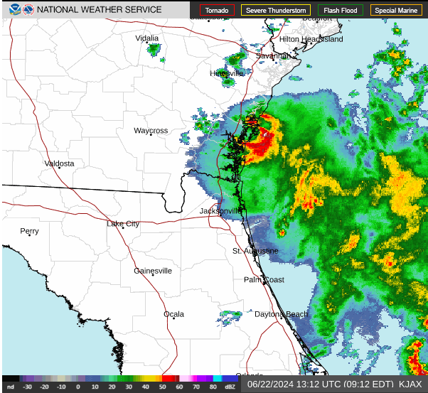
The center of the low pressure system was near Brunswick, Georgia. There was a well defined center of circulation evident on the U.S. National Weather Service radar at Jacksonville, Florida. The center of circulation was moving slowly near the coast of Georgia. The heaviest rain was falling in a ring that wrapped around the eastern side of the center of Invest 92L. Other bands of rain were over the Atlantic Ocean.
The low pressure system is forecast to move slowly inland over eastern Georgia. Heavy rain could fall over areas near the coast as Invest 92L moves inland. Heavy rain could cause flooding in some locations.
Elsewhere, a large low pressure system formed over the southwestern Gulf of Mexico near the area where Tropical Storm Alberto formed. The low pressure system has been designated as Invest 93L. At 8:00 a.m. EDT on Saturday the center of Invest 93L was located at latitude 21.0°N and longitude 95.7°W which put it about 125 miles (200 km) east-southeast of Tampico, Mexico. The low pressure system was moving toward the northwest at 13 m.p.h. (21 km/h). The maximum sustained wind speed was 35 m.p.h. (55 km/h) and there were wind gusts to 45 m.p.h. (75 km/h). The minimum surface pressure was 1005 mb.
Invest 93L will move through an environment somewhat favorable for the formation of a tropical cyclone during the next 24 hours. Invest 93L will move over water where the Sea Surface Temperatures are near 30°C. It will move under the southeastern part of an upper level ridge that stretches from Baja California to the Great Lakes. The ridge will produce northeasterly winds that will blow toward the top of the low pressure system. Those winds will cause moderate vertical wind shear. The wind shear will inhibit intensification, but the shear may not be strong enough to prevent Invest 93L from developing into a tropical cyclone. The U.S. National Hurricane Center is indicating that the probability is 50% that Invest 93L develops into a tropical cyclone.
The low pressure system designated as Invest 93L will move around the southern side of a large high pressure system over the eastern U.S. The high pressure system will steer Invest 93L toward the west-northwest during the next 24 hours. On its anticipated track, Invest 93L will approach the coast of Mexico near Tampico on Sunday.
The low pressure system designated as Invest 93L will drop heavy rain over some of the same areas where Tropical Storm Alberto dropped heavy rain. Invest 93L is very likely to cause major flash floods in parts of northern Mexico.
A U.S. Air Force Reserve Hurricane Hunter aircraft is scheduled to investigate the low pressure system designated as Invest 93L later today, if necessary.