Monthly Archives: August 2024

Tropical Cyclone Asna Spins South of Pakistan

Tropical Cyclone Asna was spinning over the Arabian Sea south of Pakistan on Saturday.  At 5:00 p.m. EDT on Saturday the center of Tropical Cyclone Asna was located at latitude 23.2°N and longitude 62.9°E which put the center about 275 miles (445 km) west-southwest of Karachi, Pakistan.  Asna was moving toward the west at 9 m.p.h. (15 km/h).  The maximum sustained wind speed was 50 m.p.h. (80 km/h) and there were wind gusts to 65 m.p.h. (105 km/h).  The minimum surface pressure was 989 mb.

Tropical Cyclone Asna strengthened on Saturday as it moved across the northern Arabian Sea south of Pakistan.  The inner end of a rainband wrapped around the western and southern side of the center of Tropical Cyclone Asna.  Thunderstorms were occurring in bands in the northern and western parts of Asna’s circulation.  Bands in the southeastern part of Asna consisted primarily of showers and lower clouds.  Storms near the center of Asna’s circulation generated upper level divergence that pumped mass away to the west of the tropical cyclone.

Winds to tropical storm force extended out 100 miles (160 km) from the center of Tropical Cyclone Asna.

Tropical Cyclone Asna will move through an environment somewhat favorable for intensification during the next 24 hours.  Asna will move over water where the Sea Surface Temperatures are near 28°C.  It will move through a region where the upper level winds are weak and there will be little vertical wind shear.  There is a large mass of drier air over Southwest Asia.  The circulation around the northern side of Asna could draw drier air into the tropical cyclone.  Tropical Cyclone Asna could strengthen a little more during the next 24 hours, if Asna does not pull too much drier air into its circulation.

Tropical Cyclone Asna will move around the southeastern part of a high pressure system over Southwest Asia.  The high pressure system will steer Asna toward the west during the next 24 hours.  On its anticipated track, Tropical Cyclone Asna will move toward Oman.


Tropical Cyclone Asna Forms Over Northern Arabian Sea

Tropical Cyclone Asna formed over the northern Arabian Sea south of Pakistan on Friday.  At 11:00 a.m. EDT on Friday the center of Tropical Cyclone Asna was located at latitude 23.9°N and longitude 66.4°E which put the center about 65 miles (105 km) south of Karachi, Pakistan. Asna was moving toward the west at 10 m.p.h. (16 km/h).  The maximum sustained wind speed was 40 m.p.h. (65 km/h) and there were wind gusts to 50 m.p.h. (80 km/h).  The minimum surface pressure was 990 mb.

A low pressure system over the Arabian Sea south of Pakistan strengthened on Friday and the India Meteorological Department designated the system as Tropical Cyclone Asna.  There was a distinct low level center of circulation in Tropical Cyclone Asna.  Thunderstorms were occurring in bands in the southern half of Asna’c circulation.  Bands in the northern part of Tropical Cyclone Asna consisted primarily of showers and lower clouds.  Storms near the center of Asna’s circulation generated upper level divergence that pumped mass away to the southwest of the tropical cyclone.

Winds to tropical storm force extended out 100 miles (160 km) from the center of Tropical Cyclone Asna.

Tropical Cyclone Asna will move through an environment somewhat favorable for intensification during the next 24 hours.  Asna will move over water where the Sea Surface Temperatures are near 28°C.  It will move through a region where the upper level winds are weak and there will be little vertical wind shear.  There is a large mass of drier air over Southwest Asia.  The circulation around the northern side of Asna could draw drier air into the tropical cyclone.  Tropical Cyclone Asna could strengthen during the next 24 hours, if it does not pull too much drier air into its circulation.

Tropical Cyclone Asna will move around the southeastern part of a high pressure system over Southwest Asia.  The high pressure system will steer Asna toward the west during the next 24 hours.  On its anticipated track, Tropical Cyclone Asna will move parallel to the coast of Pakistan.

Bands in the northern side of Tropical Cyclone Asna could bring gusty winds and locally heavy rain to southern Pakistan.  Heavy rain could cause floods in some locations.

Tropical Storm Shanshan Drops Heavy Rain on Japan

Tropical Storm Shanshan dropped heavy on parts of southwestern Japan on Thursday.  At 11:00 p.m. EDT on Thursday the center of Tropical Storm Shanshan was located at latitude 33.8°N and longitude 131.6°E which put the center about 20 miles (30 km) west of Matsuyama, Japan.  Shanshan was moving toward the east-northeast at 3 m.p.h. (5 km/h).  The maximum sustained wind speed was 45 m.p.h. (75 km/h) and there were wind gusts to 60 m.p.h. (95 km/h).  The minimum surface pressure was 990 mb.

Former Typhoon Shanshan weakened to a tropical storm as it moved across Kyushu on Thursday.  Bands in the eastern side of Tropical Storm Shanshan dropped heavy rain on parts of Kyushu, Shikoku and southwestern Honshu.  The heaviest rain fell in locations where southerly winds pushed air up the slopes of mountains.  A weather station in Yosuhara reported 16.37 inches (416 mm) of rain.  A weather station in Hongawa reported 13.05 inches (331.5 mm) of rain.  Heavy rainfall caused flash floods in some locations.

Tropical Storm Shanshan weakened on Thursday as the center moved over land.  Bands of showers and thunderstorms were revolving around the center of Shanshan’s circulation.  The heaviest rain was falling in bands in the eastern side of Tropical Storm Shanshan.  Winds to tropical storm force extended out 100 miles (160 km) from the center of Shanshan.

An upper level trough over northeastern Asia will steer Tropical Storm Shanshan toward the east-northeast during the next 24 hours.  On its anticipated track, the center Tropical Storm Shanshan will move across Shikoku during the next 24 hours.

Tropical Storm Shanshan will continue to drop heavy rain on parts of southwestern Japan on Friday.  Heavy rain will fall in parts of Shikoku and southwestern Honshu.  The heaviest rain will fall where southerly winds push air up the slopes of mountains.  Heavy rain is likely to cause additional flash floods.

Gilma Weakens East of Hawaii

Former Tropical Storm Gilma weakened east of Hawaii on Thursday.  At 5:00 p.m. EDT on Thursday the center of Tropical Depression Gilma was located at latitude 20.3°N and longitude 151.7°W which put the center about 225 miles (360 km) east of Hilo, Hawaii.  Gilma was moving toward the west-northwest at 12 m.p.h. (19 km/h).  The maximum sustained wind speed was 35 m.p.h. (55 km/h) and there were wind gusts to 45 m.p.h. (75 km/h).  The minimum surface pressure was 1010 mb.

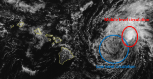
An upper level low west of California was producing strong southwesterly winds that blew toward the top of former Tropical Storm Gilma.  Those winds caused strong vertical wind shear.  The strong wind shear blew the middle and upper parts of Gilma;s circulation to the northeast of the lower portion of the circulation.

The lower portion of the circulation around Tropical Depression Gilma consisted primarily of bands of showers and low clouds.  Thunderstorms were still being produced in the middle level circulation which was northeast of the low level center of Gilma.

Tropical Depression Gilma will move through an environment that will be unfavorable for intensification during the next 24 hours.  Gilma will move over water where the Sea Surface Temperatures are near 24°C.  The upper level low west of California will continue to produce southwesterly winds that will blow toward the top of Gilma’s circulation.  Those winds will cause strong vertical wind shear.  Tropical Depression Gilma is likely to continue to weaken during the next 24 hours.

Tropical Depression Gilma will move around the southern side of a subtropical high pressure system over the Eastern and Central North Pacific Ocean.  The high pressure system will steer Gilma toward the west-northwest during the next 24 hours.  On its anticipated track, Tropical Depression Gilma pass just north of Hawaii on Friday.

The circulation in the western side of Tropical Depression Gilma could enhance the northeasterly trade winds.  Stronger trade winds could cause more rain to fall on the northeastern slopes of the Hawaiian Islands.

Elsewhere, Tropical Storm Hone was spinning southeast of Midway Island.  At 5:00 p.m. EDT on Thursday the center of Tropical Storm Hone was located at latitude 21.4°N and longitude 172.4°W which put the center about 565 miles (910 km) southeast of Midway Island.  Hone was moving toward the west-northwest at 7 m.p.h. (11 km/h).  The maximum sustained wind speed was 40 m.p.h. (65 km/h) and there were wind gusts to 50 m.p.h. (80 km/h).  The minimum surface pressure was 1006 mb.


Typhoon Shanshan Brings Wind and Rain to Kyushu

Typhoon Shanshan brought wind and rain to Kyushu on Wednesday.  At 5:00 p.m. EDT on Wednesday the center of Typhoon Shanshan was located at latitude 31.6°N and longitude 130.2°E which put the center about 35 miles (55 km) west of Kagoshima, Japan.  Shanshan was moving toward the north at 8 m.p.h. (13 km/h).  The maximum sustained wind speed was 100 m.p.h. (160 km/h) and there were wind gusts to 120 m.p.h. (195 km/h).  The minimum surface pressure was 957 mb.

Typhoon Shanshan brought wind and rain to Kyushu on Wednesday.  The eastern side of the eyewall of Shanshan moved over Makurazaki, Japan.  A weather station in Makurazaki reported a sustained wind speed of 69 m.p.h. (111 km/h).  The weather station also reported 8.42 inches (214 mm) of rain.  A weather station in Kaseda reported 10.95 inches (278 mm) of rain.  A weather station in Ibusuki reported 9.33 inches (237 mm) of rain.

Typhoon Shanshan was weakening gradually when it reached the west coast of Kyushu.  An upper level trough over northeastern Asia was producing southwest winds that were blowing toward the top of Shanshan’s circulation.  Those winds caused more vertical wind shear.  The increase in wind shear caused Typhoon Shanshan to start to weaken.

An eye was no longer visible at the center of Typhoon Shanshan on conventional satellite images.  The former eye was still being detected by radars operated by the Japan Meteorological Agency.  There were breaks in the ring of thunderstorms that surrounded the former eye.  The strongest winds were still occurring in that broken ring of storms.  Bands of showers and thunderstorms were revolving around the core of Typhoon Shanshan.

The circulation around Typhoon Shanshan was still symmetrical.  Winds to typhoon force extended out 30 miles (50 km) from the center of Shanshan’s circulation.  Winds to tropical storm force extended out 125 miles (200 km) from the center of Typhoon Shanshan.

The Hurricane Intensity Index (HII) for Typhoon Shanshan was 16.5.  The Hurricane Size Index (HSI) was 11.8 and the Hurricane Wind Intensity Size Index (HWISI) was 28.3.  Typhoon Shanshan was similar in intensity to Hurricane Idalia when Idalia hit Florida in 2023.  Shanshan was bigger than Idalia was.

Typhoon Shanshan will move around the western end of a high pressure system over the Western North Pacific Ocean.  The high pressure system will steer Shanshan toward the north during the next 12 hours.  The upper level trough over northeastern Asia will steer Shanshan toward the northeast on Thursday.  On its anticipated track, the center Typhoon Shanshan will move near the west coast of Kyushu during the next 12 hours.  Shanshan will move inland over Kyushu on Thursday.

Typhoon Shanshan will weaken gradually as it moves inland over Kyushu.  Even though Shanshan will weaken it will still produce strong winds and drop heavy rain over much of Kyushu.  Heavy rain is likely to cause flash floods in some locations,

Gilma Weakens to a Tropical Storm

Former Hurricane Gilma weakened to a tropical storm over the Central Pacific Ocean east of Hawaii on Tuesday.  At 5:00 p.m. EDT on Tuesday the center of Tropical Storm Gilma was located at latitude 18.5°N and longitude 142.1°W which put the center about 850 miles (1370 km) east of Hilo, Hawaii.  Gilma was moving toward the west at 15 m.p.h. (24 km/h).  The maximum sustained wind speed was 65 m.p.h. (105 km/h) and there were wind gusts to 80 m.p.h. (130 km/h).  The minimum surface pressure was 996 mb.

Former Hurricane Gilma ran into strong westerly winds associated with an upper level low west of California.  Those winds effectively sheared the tops off of most of the thunderstorms in Gilma’s circulation.  The strong vertical wind shear caused former Hurricane Gilma to weaken rapidly on Tuesday.  For a time the circulation around Tropical Storm Gilma consisted primarily of bands of showers and lower clouds.  New thunderstorms began to develop in bands in the eastern side of Gilma’s circulation on Tuesday afternoon.

The small size of the circulation around former Hurricane Gilma contributed to the rapid weakening that occurred when the wind shear increased.  Winds to tropical storm force extended out 70 miles (110 km) from the center of Tropical Storm Gilma.

Tropical Storm Gilma will move through an environment that will be unfavorable for intensification during the next 24 hours.  Gilma will move over water where the Sea Surface Temperatures are near 25°C.  The upper level low west of California will continue to produce westerly winds that will blow toward the top of Gilma’s circulation.  Those winds will cause moderately strong vertical wind shear.  Tropical Storm Gilma is likely to continue to weaken during the next 24 hours.

Tropical Storm Gilma will move around the southern side of a subtropical high pressure system over the Eastern and Central North Pacific Ocean.  The high pressure system will steer Gilma toward the west-northwest during the next 24 hours.  On its anticipated track, Tropical Storm Gilma will move closer to Hawaii.

Elsewhere, Tropical Storm Hone continued to move farther from Hawaii and Tropical Storm Hector continued to move westward over the Eastern North Pacific Ocean.

At 5:00 p.m. EDT on Tuesday the center of Tropical Storm Hone was located at latitude 20.1°N and longitude 166.1°W which put the center about 450 miles (725 km) west-southwest of Lihue, Hawaii.  Hone was moving toward the west-northwest at 12 m.p.h. (19 km/h).  The maximum sustained wind speed was 50 m.p.h. (80 km/h) and there were wind gusts to 65 m.p.h. (105 km/h).  The minimum surface pressure was 1002 mb.

At 5:00 p.m. EDT on Tuesday the center of Tropical Storm Hector was located at latitude 17.8°N and longitude 129.8°W which put the center about 1335 miles (2145 km) west-southwest of the southern tip of Baja California.  Hector was moving toward the west-northwest at 12 m.p.h. (19 km/h).  The maximum sustained wind speed was 50 m.p.h. (80 km/h) and there were wind gusts to 65 m.p.h. (105 km/h).  The minimum surface pressure was 1002 mb.


Typhoon Shanshan Strengthens to Equivalent of a Cat. 4 Hurricane

Typhoon Shanshan strengthened to the equivalent of a Category 4 hurricane on the Saffir-Simpson Scale over the northern Ryukyu Islands on Tuesday.  At 5:00 p.m. EDT on Tuesday the center of Typhoon Shanshan was located at latitude 29.2°N and longitude 130.0°E which put the center about 90 miles (145 km) south-southwest of Kamiyaku, Japan.  Shanshan was moving toward the north-northwest at 5 m.p.h. (8 km/h).  The maximum sustained wind speed was 130 m.p.h. (210 km/h) and there were wind gusts to 160 m.p.h. (260 km/h).  The minimum surface pressure was 932 mb.

Typhoon Shanshan intensified to the equivalent of a Category 4 hurricane on the Saffir-Simpson Scale on Tuesday.  A circular eye with a diameter of 30 miles (50 km) was at the center of Shanshan’s circulation.  The eye was surrounded by a ring of thunderstorms and the strongest winds were occurring in that ring of storms.  Bands of showers and thunderstorms were revolving around the core of Typhoon Shanshan.  Storms near the core generated strong upper level divergence that pumped mass away from the typhoon.  The removal of mass caused the surface pressure to decrease.

The circulation around Typhoon Shanshan was symmetrical.  Winds to typhoon force extended out 30 miles (50 km) from the center of Shanshan’s circulation.  Winds to tropical storm force extended out 145 miles (230 km) from the center of Typhoon Shanshan.

The Hurricane Intensity Index (HII) for Typhoon Shanshan was 25.1.  The Hurricane Size Index (HSI) was 12.1 and the Hurricane Wind Intensity Size Index (HWISI) was 37.2.  Typhoon Shanshan was similar in size and intensity to Hurricane Harvey when Harvey hit Texas in 2017.

Typhoon Shanshan will move through an environment that will be favorable for intensification during the next 24 hours.  Shanshan will move over water where the Sea Surface Temperatures are near 29°C.  It will through a region where the upper level winds are weak and there will be little vertical wind shear.  Typhoon Shanshan could intensify during the next 24 hours.

Typhoon Shanshan will move around the western end of a high pressure system over the Western North Pacific Ocean.  The high pressure system will steer Shanshan toward the north-northwest during the next 24 hours.  On its anticipated track, Typhoon Shanshan will toward western Kyushu.  Shanshan could approach western Kyushu in 36 hours.

Typhoon Shanshan will continue to produce strong winds and heavy rain in the northern Ryukyu Islands.  The eastern side of the eyewall of Shanshan will move near Yakushima.  Shanshan will be capable of causing severe damage.  Heavy rain is likely to cause flash floods in some locations.  Typhoon Shanshan will also cause a storm surge in the northern Ryukyu Islands where the wind blows the water toward the shore.


Typhoon Shanshan Intensifies to the Equivalent of a Major Hurricane

Typhoon Shanshan intensified to the equivalent of a major hurricane near the northern Ryukyu Islands on Monday evening.  At 11:00 p.m. EDT on Monday the center of Typhoon Shanshan was located at latitude 28.3°N and longitude 130.6°E which put the center about 75 miles (120 km) east of Naze, Japan.  Shanshan was moving toward the northwest at 4 m.p.h. (6 km/h).  The maximum sustained wind speed was 120 m.p.h. (195 km/h) and there were wind gusts to 150 m.p.h. (240 km/h).  The minimum surface pressure was 943 mb.

Typhoon Shanshan intensified to the equivalent of a major hurricane on Monday evening as it moved slowly near the northern Ryukyu Islands.  A small circular eye with a diameter of 12 miles (19 km) was at the center of Shanshan’s circulation.  The eye was surrounded by a ring of thunderstorms and the strongest winds were occurring in that ring of storms.  Bands of showers and thunderstorms were revolving around the core of Typhoon Shanshan.  Storms near the core generated strong upper level divergence that pumped mass away from the typhoon.  The removal of mass caused the surface pressure to decrease.

The circulation around Typhoon Shanshan was symmetrical.  Winds to typhoon force extended out 40 miles (65 km) from the center of Shanshan’s circulation.  Winds to tropical storm force extended out 125 miles (200 km) from the center of Typhoon Shanshan.

The Hurricane Intensity Index (HII) for Typhoon Shanshan was 22.1.  The Hurricane Size Index (HSI) was 13.7 and the Hurricane Wind Intensity Size Index (HWISI) was 35.8.  Typhoon Shanshan was similar in size to Hurricane Delta when Delta hit southwest Louisiana in 2020.  Shanshan was stronger than Delta was.

Typhoon Shanshan will move through an environment that will be favorable for intensification during the next 24 hours. Shanshan will move over water where the Sea Surface Temperatures are near 29°C.  It will through a region where the upper level winds are weak and there will be little vertical wind shear.  Typhoon Shanshan is likely to continue to intensify during the next 24 hours.

Typhoon Shanshan will move around the western end of a high pressure system over the Western North Pacific Ocean.  The high pressure system will steer Shanshan slowly toward the northwest during the next 24 hours.  On its anticipated track, Typhoon Shanshan will move over the northern Ryukyu Islands.  Shanshan could approach southwestern Japan in 48 hours. Shanshan could be a strong typhoon when it approaches Kyushu.

Typhoon Shanshan will bring strong winds and heavy rain to the northern Ryukyu Islands.  Shanshan will be capable of causing major damage.  Heavy rain is likely to cause flash floods in some locations.  Typhoon Shanshan will also cause a storm surge on the northern Ryukyu Islands where the wind blows the water toward the shore.

Hurricane Gilma Churns Westward

Hurricane Gilma continued to churn west toward the Central Pacific Ocean on Monday.  At 5:00 p.m. EDT on Monday the center of Hurricane Gilma was located at latitude 18.4°N and longitude 137.4°W which put the center about 1160 miles (2865 km) east of Hilo, Hawaii.  Gilma was moving toward the west at 8 m.p.h. (13 km/h).  The maximum sustained wind speed was 110 m.p.h. (175 km/h) and there were wind gusts to 130 m.p.h. (210 km/h).  The minimum surface pressure was 968 mb.

Hurricane Gilma maintained its intensity on Monday as it churned west toward the Central Pacific.  The circulation around Hurricane Gilma was very symmetrical and it exhibited a structure sometimes called an annular hurricane.  A circular eye was present at the center of Gilma’s circulation.  A ring of thunderstorms surrounded the eye and the strongest winds were occurring in that ring of storms.  A several short bands of showers and thunderstorms were revolving around the core of Hurricane Gilma.  Storms near the core of Gilma generated upper level divergence that pumped mass away from the hurricane.  The divergence of mass in the upper levels of the atmosphere was nearly balanced by the inflow of mass in the lower levels.  The balance of mass caused the surface pressure to remain nearly steady.

The circulation around Hurricane Gilma was small.  Winds to hurricane force extended out 20 miles (30 km) from the center of Gilma’s circulation.  Winds to tropical storm force extended out 80 miles (130 km) from the center of Hurricane Gilma.

Hurricane Gilma will move through an environment that will be marginal for intensification during the next 24 hours.  Gilma will move over water where the Sea Surface Temperatures are near 26°C.  It will move under the axis of an upper level ridge over the Eastern and Central North Pacific.  The upper level winds are weak near the axis of the ridge.  Hurricane Gilma is likely to maintain its intensity on Tuesday unless the vertical wind shear increases.  Since the circulation around Gilma is small, if the wind shear increases, Hurricane Gilma could start to weaken.

Hurricane Gilma will move around the southern side of a subtropical high pressure system over the Eastern and Central North Pacific Ocean.  The high pressure system will steer Gilma toward the west-northwest during the next 24 hours.  On its anticipated track, Hurricane Gilma will move closer to Hawaii.

Elsewhere, Tropical Storm Hone moved farther away to the southwest of Hawaii and Tropical Storm Hector moved westward over the Eastern North Pacific Ocean.

At 5:00 p.m. EDT on Monday the center of Tropical Storm Hone was located at latitude 19.2°N and longitude 161.6°W which put the center about 240 miles (385 km) south-southwest of Lihue, Hawaii.  Hone was moving toward the west at 13 m.p.h. (20 km/h).  The maximum sustained wind speed was 65 m.p.h. (105 km/h) and there were wind gusts to 80 m.p.h. (130 km/h).  The minimum surface pressure was 998 mb.

At 5:00 p.m. EDT on Sunday the center of Tropical Storm Hector was located at latitude 16.5°N and longitude 125.8°W which put the center about 1125 miles (1805 km) west-southwest of the southern tip of Baja California.  Hector was moving toward the west-northwest at 10 m.p.h. (16 km/h).  The maximum sustained wind speed was 50 m.p.h. (80 km/h) and there were wind gusts to 65 m.p.h. (105 km/h).  The minimum surface pressure was 998 mb.


Hurricane Hone Brings Wind and Rain to Hawaii

Hurricane Hone brought wind and rain to Hawaii on Sunday.  At 11:00 p.m. EDT on Sunday the center of Hurricane Hone was located at latitude 19.1°N and longitude 158.6°W which put the center about 160 miles (260 km) south-southwest of Honolulu, Hawaii.  Hone was moving toward the west at 13 m.p.h. (20 km/h).  The maximum sustained wind speed was 75 m.p.h. (120 km/h) and there were wind gusts to 90 m.p.h. (145 km/h).  The minimum surface pressure was 994 mb.

Bands in the northern side of Hurricane Hone brought wind and rain to the Big Island of Hawaii on Sunday.  A weather station at Bradshaw Army Airfield (PHSF) measured a sustained wind speed of 35 m.p.h. (56 km/h) and a wind gust of 44 m.p.h. (71 km/h).  The weather station also reported 1.35 inches (34.3 mm) of rain.  A weather station at Kahuku reported 8.52 inches (216.4 mm) of rain.

Hurricane Hone weakened on Sunday evening as it passed south of Hawaii.  An upper level trough northwest of the Hawaiian Islands was producing southwesterly winds that were blowing toward the top of Hone’s circulation.  Those winds were causing strong vertical wind shear and the wind shear was causing Hurricane Hone to weaken.  An eye was no longer visible at the center of Hone’s circulation.  The wind shear was also causing the distribution of thunderstorms to become asymmetrical.  Thunderstorms were still occurring in bands in the eastern part of Hurricane Hone.  Bands in the western part of Hone’s circulation consisted primarily of showers and low clouds.

Hurricane force winds were still occurring in the northeastern quadrant of Hurricane Hone.  Winds to hurricane force extended out 15 miles (25 km) in the northeastern quadrant of Hone’s circulation.  Winds to tropical storm force extended out 90 miles (145 km) from the center of Hurricane Hone.

Hurricane Hone will move through an environment that will be unfavorable for intensification during the next 24 hours.  Hone will move over water where the Sea Surface Temperatures are near 27°C.  However, the upper level trough northwest of the Hawaiian Islands will continue to cause strong vertical wind shear.  The wind shear will cause Hurricane Hone to weaken on Monday.

Hurricane Hone will move around the southern side of a subtropical high pressure system over the Eastern North Pacific and Central Pacific.  The high pressure system will steer Hone toward the west-northwest during the next 24 hours.  On its anticipated track, Hurricane Hone will move farther away from Hawaii on Monday.

Elsewhere, Hurricane Gilma started to weaken and Tropical Storm Hector formed over the Eastern North Pacific Ocean.

At 11:00 p.m. EDT on Sunday the center of Hurricane Gilma was located at latitude 18.1°N and longitude 135.1°W which put the center about 1310 miles (2110 km) east of Hilo, Hawaii.  Gilma was moving toward the west at 9 m.p.h. (15 km/h).  The maximum sustained wind speed was 105 m.p.h. (165 km/h) and there were wind gusts to 125 m.p.h. (200 km/h).  The minimum surface pressure was 972 mb.

At 11:00 p.m. EDT on Monday the center of Tropical Storm Hector was located at latitude 16.2°N and longitude 123.2°W which put the center about 980 miles (1580 km) west-southwest of the southern tip of Baja California.  Hector was moving toward the west at 12 m.p.h. (19 km/h).  The maximum sustained wind speed was 45 m.p.h. (75 km/h) and there were wind gusts to 60 m.p.h. (95 km/h).  The minimum surface pressure was 1001 mb.