Tag Archives: Hone

Gilma Weakens East of Hawaii

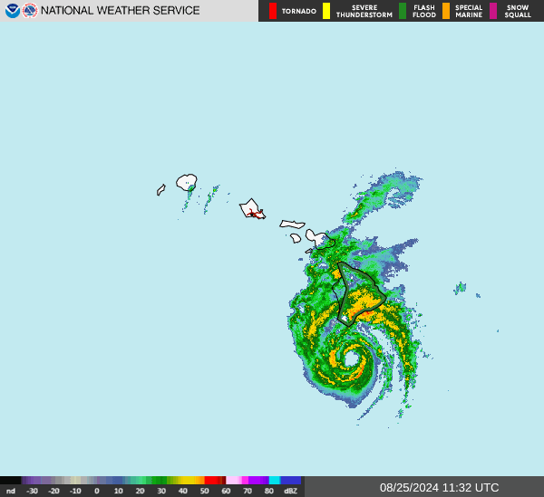
Former Tropical Storm Gilma weakened east of Hawaii on Thursday.  At 5:00 p.m. EDT on Thursday the center of Tropical Depression Gilma was located at latitude 20.3°N and longitude 151.7°W which put the center about 225 miles (360 km) east of Hilo, Hawaii.  Gilma was moving toward the west-northwest at 12 m.p.h. (19 km/h).  The maximum sustained wind speed was 35 m.p.h. (55 km/h) and there were wind gusts to 45 m.p.h. (75 km/h).  The minimum surface pressure was 1010 mb.

An upper level low west of California was producing strong southwesterly winds that blew toward the top of former Tropical Storm Gilma.  Those winds caused strong vertical wind shear.  The strong wind shear blew the middle and upper parts of Gilma;s circulation to the northeast of the lower portion of the circulation.

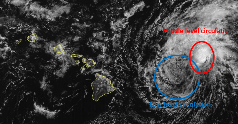
The lower portion of the circulation around Tropical Depression Gilma consisted primarily of bands of showers and low clouds.  Thunderstorms were still being produced in the middle level circulation which was northeast of the low level center of Gilma.

Tropical Depression Gilma will move through an environment that will be unfavorable for intensification during the next 24 hours.  Gilma will move over water where the Sea Surface Temperatures are near 24°C.  The upper level low west of California will continue to produce southwesterly winds that will blow toward the top of Gilma’s circulation.  Those winds will cause strong vertical wind shear.  Tropical Depression Gilma is likely to continue to weaken during the next 24 hours.

Tropical Depression Gilma will move around the southern side of a subtropical high pressure system over the Eastern and Central North Pacific Ocean.  The high pressure system will steer Gilma toward the west-northwest during the next 24 hours.  On its anticipated track, Tropical Depression Gilma pass just north of Hawaii on Friday.

The circulation in the western side of Tropical Depression Gilma could enhance the northeasterly trade winds.  Stronger trade winds could cause more rain to fall on the northeastern slopes of the Hawaiian Islands.

Elsewhere, Tropical Storm Hone was spinning southeast of Midway Island.  At 5:00 p.m. EDT on Thursday the center of Tropical Storm Hone was located at latitude 21.4°N and longitude 172.4°W which put the center about 565 miles (910 km) southeast of Midway Island.  Hone was moving toward the west-northwest at 7 m.p.h. (11 km/h).  The maximum sustained wind speed was 40 m.p.h. (65 km/h) and there were wind gusts to 50 m.p.h. (80 km/h).  The minimum surface pressure was 1006 mb.


Gilma Weakens to a Tropical Storm

Former Hurricane Gilma weakened to a tropical storm over the Central Pacific Ocean east of Hawaii on Tuesday.  At 5:00 p.m. EDT on Tuesday the center of Tropical Storm Gilma was located at latitude 18.5°N and longitude 142.1°W which put the center about 850 miles (1370 km) east of Hilo, Hawaii.  Gilma was moving toward the west at 15 m.p.h. (24 km/h).  The maximum sustained wind speed was 65 m.p.h. (105 km/h) and there were wind gusts to 80 m.p.h. (130 km/h).  The minimum surface pressure was 996 mb.

Former Hurricane Gilma ran into strong westerly winds associated with an upper level low west of California.  Those winds effectively sheared the tops off of most of the thunderstorms in Gilma’s circulation.  The strong vertical wind shear caused former Hurricane Gilma to weaken rapidly on Tuesday.  For a time the circulation around Tropical Storm Gilma consisted primarily of bands of showers and lower clouds.  New thunderstorms began to develop in bands in the eastern side of Gilma’s circulation on Tuesday afternoon.

The small size of the circulation around former Hurricane Gilma contributed to the rapid weakening that occurred when the wind shear increased.  Winds to tropical storm force extended out 70 miles (110 km) from the center of Tropical Storm Gilma.

Tropical Storm Gilma will move through an environment that will be unfavorable for intensification during the next 24 hours.  Gilma will move over water where the Sea Surface Temperatures are near 25°C.  The upper level low west of California will continue to produce westerly winds that will blow toward the top of Gilma’s circulation.  Those winds will cause moderately strong vertical wind shear.  Tropical Storm Gilma is likely to continue to weaken during the next 24 hours.

Tropical Storm Gilma will move around the southern side of a subtropical high pressure system over the Eastern and Central North Pacific Ocean.  The high pressure system will steer Gilma toward the west-northwest during the next 24 hours.  On its anticipated track, Tropical Storm Gilma will move closer to Hawaii.

Elsewhere, Tropical Storm Hone continued to move farther from Hawaii and Tropical Storm Hector continued to move westward over the Eastern North Pacific Ocean.

At 5:00 p.m. EDT on Tuesday the center of Tropical Storm Hone was located at latitude 20.1°N and longitude 166.1°W which put the center about 450 miles (725 km) west-southwest of Lihue, Hawaii.  Hone was moving toward the west-northwest at 12 m.p.h. (19 km/h).  The maximum sustained wind speed was 50 m.p.h. (80 km/h) and there were wind gusts to 65 m.p.h. (105 km/h).  The minimum surface pressure was 1002 mb.

At 5:00 p.m. EDT on Tuesday the center of Tropical Storm Hector was located at latitude 17.8°N and longitude 129.8°W which put the center about 1335 miles (2145 km) west-southwest of the southern tip of Baja California.  Hector was moving toward the west-northwest at 12 m.p.h. (19 km/h).  The maximum sustained wind speed was 50 m.p.h. (80 km/h) and there were wind gusts to 65 m.p.h. (105 km/h).  The minimum surface pressure was 1002 mb.


Hurricane Gilma Churns Westward

Hurricane Gilma continued to churn west toward the Central Pacific Ocean on Monday.  At 5:00 p.m. EDT on Monday the center of Hurricane Gilma was located at latitude 18.4°N and longitude 137.4°W which put the center about 1160 miles (2865 km) east of Hilo, Hawaii.  Gilma was moving toward the west at 8 m.p.h. (13 km/h).  The maximum sustained wind speed was 110 m.p.h. (175 km/h) and there were wind gusts to 130 m.p.h. (210 km/h).  The minimum surface pressure was 968 mb.

Hurricane Gilma maintained its intensity on Monday as it churned west toward the Central Pacific.  The circulation around Hurricane Gilma was very symmetrical and it exhibited a structure sometimes called an annular hurricane.  A circular eye was present at the center of Gilma’s circulation.  A ring of thunderstorms surrounded the eye and the strongest winds were occurring in that ring of storms.  A several short bands of showers and thunderstorms were revolving around the core of Hurricane Gilma.  Storms near the core of Gilma generated upper level divergence that pumped mass away from the hurricane.  The divergence of mass in the upper levels of the atmosphere was nearly balanced by the inflow of mass in the lower levels.  The balance of mass caused the surface pressure to remain nearly steady.

The circulation around Hurricane Gilma was small.  Winds to hurricane force extended out 20 miles (30 km) from the center of Gilma’s circulation.  Winds to tropical storm force extended out 80 miles (130 km) from the center of Hurricane Gilma.

Hurricane Gilma will move through an environment that will be marginal for intensification during the next 24 hours.  Gilma will move over water where the Sea Surface Temperatures are near 26°C.  It will move under the axis of an upper level ridge over the Eastern and Central North Pacific.  The upper level winds are weak near the axis of the ridge.  Hurricane Gilma is likely to maintain its intensity on Tuesday unless the vertical wind shear increases.  Since the circulation around Gilma is small, if the wind shear increases, Hurricane Gilma could start to weaken.

Hurricane Gilma will move around the southern side of a subtropical high pressure system over the Eastern and Central North Pacific Ocean.  The high pressure system will steer Gilma toward the west-northwest during the next 24 hours.  On its anticipated track, Hurricane Gilma will move closer to Hawaii.

Elsewhere, Tropical Storm Hone moved farther away to the southwest of Hawaii and Tropical Storm Hector moved westward over the Eastern North Pacific Ocean.

At 5:00 p.m. EDT on Monday the center of Tropical Storm Hone was located at latitude 19.2°N and longitude 161.6°W which put the center about 240 miles (385 km) south-southwest of Lihue, Hawaii.  Hone was moving toward the west at 13 m.p.h. (20 km/h).  The maximum sustained wind speed was 65 m.p.h. (105 km/h) and there were wind gusts to 80 m.p.h. (130 km/h).  The minimum surface pressure was 998 mb.

At 5:00 p.m. EDT on Sunday the center of Tropical Storm Hector was located at latitude 16.5°N and longitude 125.8°W which put the center about 1125 miles (1805 km) west-southwest of the southern tip of Baja California.  Hector was moving toward the west-northwest at 10 m.p.h. (16 km/h).  The maximum sustained wind speed was 50 m.p.h. (80 km/h) and there were wind gusts to 65 m.p.h. (105 km/h).  The minimum surface pressure was 998 mb.


Hurricane Hone Brings Wind and Rain to Hawaii

Hurricane Hone brought wind and rain to Hawaii on Sunday.  At 11:00 p.m. EDT on Sunday the center of Hurricane Hone was located at latitude 19.1°N and longitude 158.6°W which put the center about 160 miles (260 km) south-southwest of Honolulu, Hawaii.  Hone was moving toward the west at 13 m.p.h. (20 km/h).  The maximum sustained wind speed was 75 m.p.h. (120 km/h) and there were wind gusts to 90 m.p.h. (145 km/h).  The minimum surface pressure was 994 mb.

Bands in the northern side of Hurricane Hone brought wind and rain to the Big Island of Hawaii on Sunday.  A weather station at Bradshaw Army Airfield (PHSF) measured a sustained wind speed of 35 m.p.h. (56 km/h) and a wind gust of 44 m.p.h. (71 km/h).  The weather station also reported 1.35 inches (34.3 mm) of rain.  A weather station at Kahuku reported 8.52 inches (216.4 mm) of rain.

Hurricane Hone weakened on Sunday evening as it passed south of Hawaii.  An upper level trough northwest of the Hawaiian Islands was producing southwesterly winds that were blowing toward the top of Hone’s circulation.  Those winds were causing strong vertical wind shear and the wind shear was causing Hurricane Hone to weaken.  An eye was no longer visible at the center of Hone’s circulation.  The wind shear was also causing the distribution of thunderstorms to become asymmetrical.  Thunderstorms were still occurring in bands in the eastern part of Hurricane Hone.  Bands in the western part of Hone’s circulation consisted primarily of showers and low clouds.

Hurricane force winds were still occurring in the northeastern quadrant of Hurricane Hone.  Winds to hurricane force extended out 15 miles (25 km) in the northeastern quadrant of Hone’s circulation.  Winds to tropical storm force extended out 90 miles (145 km) from the center of Hurricane Hone.

Hurricane Hone will move through an environment that will be unfavorable for intensification during the next 24 hours.  Hone will move over water where the Sea Surface Temperatures are near 27°C.  However, the upper level trough northwest of the Hawaiian Islands will continue to cause strong vertical wind shear.  The wind shear will cause Hurricane Hone to weaken on Monday.

Hurricane Hone will move around the southern side of a subtropical high pressure system over the Eastern North Pacific and Central Pacific.  The high pressure system will steer Hone toward the west-northwest during the next 24 hours.  On its anticipated track, Hurricane Hone will move farther away from Hawaii on Monday.

Elsewhere, Hurricane Gilma started to weaken and Tropical Storm Hector formed over the Eastern North Pacific Ocean.

At 11:00 p.m. EDT on Sunday the center of Hurricane Gilma was located at latitude 18.1°N and longitude 135.1°W which put the center about 1310 miles (2110 km) east of Hilo, Hawaii.  Gilma was moving toward the west at 9 m.p.h. (15 km/h).  The maximum sustained wind speed was 105 m.p.h. (165 km/h) and there were wind gusts to 125 m.p.h. (200 km/h).  The minimum surface pressure was 972 mb.

At 11:00 p.m. EDT on Monday the center of Tropical Storm Hector was located at latitude 16.2°N and longitude 123.2°W which put the center about 980 miles (1580 km) west-southwest of the southern tip of Baja California.  Hector was moving toward the west at 12 m.p.h. (19 km/h).  The maximum sustained wind speed was 45 m.p.h. (75 km/h) and there were wind gusts to 60 m.p.h. (95 km/h).  The minimum surface pressure was 1001 mb.


Hone Strengthens to a Hurricane South of Hawaii

Former Tropical Storm Hone strengthened to a hurricane south of Hawaii on Saturday night.  At 5:00 a.m. EDT on Sunday the center of Hurricane Hone was located at latitude 18.2°N and longitude 155.3°W which put the center about 105 miles (165 km) south of Hilo, Hawaii.    Hone was moving toward the west at 12 m.p.h. (19 km/h).   The maximum sustained wind speed was 75 m.p.h. (120 km/h) and there were wind gusts to 90 m.p.h. (145 km/h).   The minimum surface pressure was 991 mb.

A Tropical Storm Warning was in effect for Hawaii County (the Big Island).

Former Tropical Storm Hone strengthened to a hurricane during Saturday night as the center of Hone moved just south of South Point, Hawaii.  A circular eye with a diameter of 30 miles formed at the center of Hone’s circulation.  The eye was surrounded by a ring of thunderstorms and the strongest winds were occurring in that ring of storm,  Bands of showers and thunderstorms were revolving around the center of Hone’s circulation.  Storms near the center of Hone generated more upper level divergence that pumped mass away from the hurricane.  The removal of more mass caused the surface pressure to decrease.

The size of the circulation around Hurricane Hone increased a little during Saturday night.  Winds to hurricane force extended out 20 miles (30 km) in the northern side of Hone’s circulation.  Winds to tropical storm force extended out 130 miles (210 km) from the center of Hurricane Hone.

Hurricane Hone will move through an environment favorable for intensification during the next 24 hours.  Hone will move over water where the Sea Surface Temperatures are near 27°C.  It will move under the southern side of an upper level ridge centered west of Hawaii.  The upper level ridge will produce northeasterly winds that will blow toward the top of Hone’s circulation.  Those winds will cause some vertical wind shear.  The vertical wind shear will inhibit intensification, but the wind shear will not be enough to prevent intensification.  Hurricane Hone is likely to intensify gradually during the next 24 hours.

Hurricane Hone will move around the southern side of a subtropical high pressure system over the Eastern North Pacific and Central Pacific.  The high pressure system will steer Hone toward the west-northwest during the next 24 hours.  On its anticipated track, the center Hurricane Hone will move away from of Hawaii County (the Big Island) on Sunday.

The core of Hurricane Hone where the strongest winds are will pass south of Hawaii County.  Bands in the northern side of Hone’s circulation could bring strong winds to the Big Island.  Electricity outages are likely.  Those bands will also drop heavy rain on parts of Hawaii County.  Heavy rain is likely to cause flash floods in some locations.

A Flood Watch is in effect for Hawaii County.

Elsewhere, Hurricane Gilma intensified to Category 4 on the Saffir-Simpson Scale over the Eastern North Pacific Ocean east of Hawaii.  At 5:00 a.m. EDT on Sunday the center of Hurricane Gilma was located at latitude 18.0°N and longitude 132.5°W which put the center about 1480 miles (2380 km) east of Hilo, Hawaii.  Gilma was moving toward the west-northwest at 9 m.p.h. (15 km/h).  The maximum sustained wind speed was 130 m.p.h. (210 km/h) and there were wind gusts to 155 m.p.h. (250 km/h).  The minimum surface pressure was 949 mb.


Tropical Storm Hone Moves Southeast of Hawaii

Tropical Storm Hone moved southeast of Hawaii on Saturday.  At 5:00 p.m. EDT on Saturday the center of Tropical Storm Hone was located at latitude 17.7°N and longitude 153.2°W which put the center about 185 miles (300 km) southeast of Hilo, Hawaii.   Hone was moving toward the west at 15 m.p.h. (24 km/h).  The maximum sustained wind speed was 65 m.p.h. (105 km/h) and there were wind gusts to 80 m.p.h. (120 km/h).  The minimum surface pressure was 1000 mb.

A Tropical Storm Warning was in effect for Hawaii County (the Big Island).

Tropical Storm Hone continued to strengthen gradually on Saturday.  The low level circulation of Tropical Storm Hone remained well organized and very symmetrical.  The inner end of a rainband wrapped around the eastern side of the center of Hone’s circulation.  Bands of showers and thunderstorms were revolving around the center of Tropical Storm Hone.  Storms near the center of circulation generated upper level divergence that pumped mass away from the tropical storm.  The removal of mass in the upper levels was nearly balanced by the inflow of mass in the lower levels of the atmosphere.  The balanced transport of mass caused the surface pressure to remain steady.

Even though the low level circulation of Tropical Storm Hone was very symmetrical, the distribution of wind speeds was asymmetrical.  Winds to tropical storm force extended out 125 miles (200 km) in the northern side of Hone’s circulation.  Winds to tropical storm force extended out 80 miles (130 km) in the southern side of Tropical Storm Hone.

Tropical Storm Hone will move through an environment favorable for intensification during the next 24 hours.  Hone will move over water where the Sea Surface Temperatures are near 27°C. It will move under the southern side of an upper level ridge centered west of Hawaii.  The upper level ridge will produce northeasterly winds that will blow toward the top of Hone’s circulation.  Those winds will cause some vertical wind shear.  The vertical wind shear will inhibit intensification, but the wind shear will not be enough to prevent intensification.  Tropical Storm Hone is likely to intensify gradually during the next 24 hours.

Tropical Storm Hone will move around the southern side of a subtropical high pressure system over the Eastern North Pacific and Central Pacific.  The high pressure system will steer Hone toward the west-northwest during the next 24 hours.  On its anticipated track, the center Tropical Storm Hone will pass just south of Hawaii County (the Big Island) on Saturday night.

Even though the center of Tropical Storm Hone is likely to pass south of Hawaii, it could bring winds to tropical storm force to Hawaii County.  Hone could also produce locally heavy rain.

Elsewhere, Hurricane Gilma churned westward over the Eastern North Pacific Ocean east of Hawaii.  At 5:00 p.m. EDT on Saturday the center of Hurricane Gilma was located at latitude 17.7°N and longitude 130.9°W which put the center about 1585 miles (2555 km) east of Hilo, Hawaii.  Gilma was moving toward the west at 9 m.p.h. (15 km/h).  The maximum sustained wind speed was 110 m.p.h. (175 km/h) and there were wind gusts to 130 m.p.h. (210 km/h).  The minimum surface pressure was 968 mb.


Hone Prompts Tropical Storm Warning for Hawaii County

The potential risk posed by Tropical Storm Hone prompted the issuance of a Tropical Storm Warning for Hawaii County.  At 11:00 p.m. EDT on Friday the center of Tropical Storm Hone was located at latitude 16.9°N and longitude 149.3°W which put the center about 425 miles (685 km) east-southeast of Hilo, Hawaii.  Hone was moving toward the west at 16 m.p.h. (26 km/h).  The maximum sustained wind speed was 50 m.p.h. (80 km/h) and there were wind gusts to 65 m.p.h. (105 km/h).  The minimum surface pressure was 1000 mb.

A Tropical Storm Warning was in effect for Hawaii County (the Big Island).

Tropical Storm Hone strengthened gradually on Friday.  The low level circulation of Tropical Storm Hone was well developed and very symmetrical.  More thunderstorms developed in the inner end of a rainband that wrapped around the eastern side of the center of Hone’s circulation.  Bands of showers and thunderstorms were revolving around the center of Tropical Storm Hone.  Storms near the center of circulation generated upper level divergence that pumped mass away from the tropical storm.

Even though the low level circulation of Tropical Storm Hone was very symmetrical, the distribution of winds speeds was asymmetrical.  Winds to tropical storm force extended out 115 miles (185 km) in the northern side of Hone’s circulation.  Winds to tropical storm force extended out 60 miles in the southern side of Tropical Storm Hone.

Tropical Storm Hone will move through an environment favorable for intensification during the next 24 hours.  Hone will move over water where the Sea Surface Temperatures are near 28°C.  It will move through a region where the upper level winds are weak and there will be little vertical wind shear.  Tropical Storm Hone is likely to intensify gradually during the next 24 hours.

Tropical Storm Hone will move around the southern side of a subtropical high pressure system over the Eastern North Pacific and Central Pacific.  The high pressure system will steer Hone toward the west-northwest during the next 24 hours.  On its anticipated track, the center Tropical Storm Hone will pass just south of Hawaii County (the Big Island) on Saturday night.

Even though the center of Tropical Storm Hone is likely to pass south of Hawaii, it could bring winds to tropical storm force to Hawaii County.  Hone could also produce locally heavy rain.

Elsewhere, Hurricane Gilma weakened gradually east of Hawaii.  At 11:00 p.m. EDT on Friday the center of Hurricane Gilma was located at latitude 17.5°N and longitude 128.4°W which put the center about 1750 miles (2820 km) east of Hilo, Hawaii.  Gilma was moving toward the west at 9 m.p.h. (15 km/h).  The maximum sustained wind speed was 105 m.p.h. (165 km/h) and there were wind gusts to 125 m.p.h. (200 km/h).  The minimum surface pressure was 970 mb.


Tropical Storm Hone Forms East-southeast of Hawaii

Tropical Storm Hone formed east-southeast of Hawaii on Thursday afternoon.  At 5:00 p.m. EDT on Thursday the center of Tropical Storm Hone was located at latitude 15.9°N and longitude 142.2°W which put the center about 885 miles (1430 km) east-southeast of Hilo, Hawaii.  Hone was moving toward the west-northwest at 14 m.p.h. (22 km/h).  The maximum sustained wind speed was 40 m.p.h. (65 km/h) and there were wind gusts to 50 m.p.h. (80 km/h).  The minimum surface pressure was 1005 mb.

A low pressure system over the Central Pacific Ocean east-southeast of Hawaii strengthened on Thursday afternoon and the U.S. Central Pacific Hurricane Center designated the system as Tropical Storm Hone.  More thunderstorms developed near the center of Hone’s circulation on Thursday afternoon.  More thunderstorms also formed in bands revolving around the center of Tropical Storm Hone.  Storms near the center of Hone began to generate upper level divergence that pumped mass away from the tropical storm.

The circulation around Tropical Storm Hone was small.  Winds to tropical storm force extended out 20 miles in the northern side of Hone’s circulation.  The winds in the southern part of Tropical Storm Hone were blowing at less than tropical storm force.

Tropical Storm Hone will move through an environment favorable for intensification during the next 24 hours.  Hone will move over water where the Sea Surface Temperatures are near 27°C.  It will move under the southern part of an upper level ridge over the Eastern North Pacific and the Central Pacific.  The upper level ridge will produce northeasterly winds that will blow toward the top of Hone’s circulation.  Those winds will cause some vertical wind shear, but the wind shear will not be enough to prevent intensification.  Tropical Storm Hone is likely to intensify gradually during the next 24 hours.

Tropical Storm Hone will move around the southern side of a subtropical high pressure system over the Eastern North Pacific and Central Pacific.  The high pressure system will steer Hone toward the west-northwest during the next 24 hours.  On its anticipated track, Tropical Storm Hone will move closer to Hawaii.  Hone could be southeast of Hawaii by Saturday evening.