Tag Archives: Midway Island

Gilma Weakens East of Hawaii

Former Tropical Storm Gilma weakened east of Hawaii on Thursday.  At 5:00 p.m. EDT on Thursday the center of Tropical Depression Gilma was located at latitude 20.3°N and longitude 151.7°W which put the center about 225 miles (360 km) east of Hilo, Hawaii.  Gilma was moving toward the west-northwest at 12 m.p.h. (19 km/h).  The maximum sustained wind speed was 35 m.p.h. (55 km/h) and there were wind gusts to 45 m.p.h. (75 km/h).  The minimum surface pressure was 1010 mb.

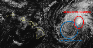
An upper level low west of California was producing strong southwesterly winds that blew toward the top of former Tropical Storm Gilma.  Those winds caused strong vertical wind shear.  The strong wind shear blew the middle and upper parts of Gilma;s circulation to the northeast of the lower portion of the circulation.

The lower portion of the circulation around Tropical Depression Gilma consisted primarily of bands of showers and low clouds.  Thunderstorms were still being produced in the middle level circulation which was northeast of the low level center of Gilma.

Tropical Depression Gilma will move through an environment that will be unfavorable for intensification during the next 24 hours.  Gilma will move over water where the Sea Surface Temperatures are near 24°C.  The upper level low west of California will continue to produce southwesterly winds that will blow toward the top of Gilma’s circulation.  Those winds will cause strong vertical wind shear.  Tropical Depression Gilma is likely to continue to weaken during the next 24 hours.

Tropical Depression Gilma will move around the southern side of a subtropical high pressure system over the Eastern and Central North Pacific Ocean.  The high pressure system will steer Gilma toward the west-northwest during the next 24 hours.  On its anticipated track, Tropical Depression Gilma pass just north of Hawaii on Friday.

The circulation in the western side of Tropical Depression Gilma could enhance the northeasterly trade winds.  Stronger trade winds could cause more rain to fall on the northeastern slopes of the Hawaiian Islands.

Elsewhere, Tropical Storm Hone was spinning southeast of Midway Island.  At 5:00 p.m. EDT on Thursday the center of Tropical Storm Hone was located at latitude 21.4°N and longitude 172.4°W which put the center about 565 miles (910 km) southeast of Midway Island.  Hone was moving toward the west-northwest at 7 m.p.h. (11 km/h).  The maximum sustained wind speed was 40 m.p.h. (65 km/h) and there were wind gusts to 50 m.p.h. (80 km/h).  The minimum surface pressure was 1006 mb.


Hurricane Dora Moves Across the International Date Line

Hurricane Dora moved across the International Date Line on Friday night. At 11:00 p.m. EDT on Friday the center of Hurricane Dora was located at latitude 15.9°N and longitude 179.4°E which put it about 860 miles (1390 km) south of Midway Island. Dora was moving toward the west-northwest at 18 m.p.h. (30 km/h). The maximum sustained wind speed was 105 m.p.h. (165 km/h) and there were wind gusts to 125 m.p.h. (200 km/h). The minimum surface pressure was 972 mb.

Hurricane Dora was weakening as it moved across the International Date Line on Friday night. Dora was moving under the western part of an upper level ridge over the Central Pacific Ocean. The ridge was producing southerly winds that were blowing toward the top of Dora’s circulation. Those winds were causing the vertical wind shear to increase and the wind shear was causing Hurricane Dora to weaken.

There still was a small eye at the center of Hurricane Dora. The eye was surrounded by a ring of thunderstorms and the strongest winds were occurring in that ring of storms. Bands of showers and thunderstorms were revolving around the core of Dora’s circulation. Storms near the core generated upper level divergence that pumped mass away from the hurricane.

The circulation around Hurricane Dora was small. Winds to hurricane force extended out 25 miles (40 km) from the center of Dora. Winds to tropical storm force extended out 90 miles (145 km) from the center of circulation. The Hurricane Intensity Index (HII) was 17.8. The Hurricane Size Index (HSI) was 7.0 and the Hurricane Wind Intensity Size Index (HWISI) was 24.8.

Hurricane Dora will move through an environment that will be unfavorable for intensification during the next 24 hours. Dora will move over water where the Sea Surface Temperatures are near 28°C. However, the upper level ridge will continue to cause moderate to strong vertical wind shear. The wind shear will cause Hurricane Dora to weaken during the next 24 hours. Dora could weaken quickly even though it is over warm water, because it is such a small hurricane.

Hurricane Dora will move around the western side of a high pressure system over the Central Pacific Ocean. The high pressure system will steer Dora toward the west-northwest during the next 24 hours. On its anticipated track Hurricane Dora could be east of Wake Island in 48 hours.

Tropical Storm Yamaneko Moves North of Wake Island

Tropical Storm Yamaneko moved north of Wake Island on Sunday. At 4:00 p.m. EST on Sunday the center of Tropical Storm Yamaneko was located at latitude 23.4°N and longitude 166.0°E which put it about 245 miles (395 km) north of Wake Island. Yamaneko was moving toward the north at 7 m.p.h. (11 km/h). The maximum sustained wind speed was 40 m.p.h. (65 km/h) and there were wind gusts to 50 m.p.h. (80 km/h). The minimum surface pressure was 1000 mb.

Tropical Storm Yamaneko moved farther north of Wake Island on Sunday. The distribution of thunderstorms in Yamaneko was asymmetrical. Thunderstorms were occurring in bands in the far eastern part of Tropical Storm Yamaneko. Bands in the rest of Yamaneko’s circulation consisted primarily of showers and lower clouds. An upper level trough southeast of Japan was producing strong southwesterly winds that were blowing across the top of Tropical Storm Yamaneko. Those winds were causing strong vertical wind shear. The strong vertical wind shear was causing the upper part of Yamaneko’s circulation to tilt toward the northeast. The strong upper level winds were also blowing off the tops of thunderstorms that started to form near the center of Yamaneko and in the western part of the circulation.

Tropical Storm Yamaneko will move through an environment that will cause it to make a transition to an extratropical cyclone during the next 36 hours. Yamaneko will move over water where the Sea Surface Temperatures are colder than 26˚C. The upper level trough southeast of Japan will continue to cause strong vertical wind shear. A combination of cooler water and strong vertical wind shear will cause Tropical Storm Yamaneko to make a transition to an extratropical cyclone.

The upper level trough will steer Tropical Storm Yamaneko toward the north-northeast during the next 36 hours. On its anticipated track, Tropical Storm Yamaneko will pass far to the west of Midway Island in 24 hours.

Banyan Rapidly Intensifies Into a Typhoon

Tropical Storm Banyan rapidly intensified into a typhoon on Saturday.  At 5:00 p.m. EDT on Saturday the center of Typhoon Banyan was located at latitude 20.8°N and longitude 164.3°E which put it about 165 miles (265 km) west-northwest of Wake Island.  Banyan was moving toward the north-northwest at 7 m.p.h. (11 km/h).  The maximum sustained wind speed was 90 m.p.h. (145 km/h) and there were wind gusts to 115 m.p.h. (185 km/h).  The minimum surface pressure was 976 mb.

Banyan intensified rapidly from a tropical storm into a typhoon in less than 36 hours.  Banyan is a small well organized typhoon.  There is a small circular eye at the center of circulation.  The eye is surrounded by a ring of strong thunderstorms.  The strongest winds are occurring in that ring of storms.  A primary band of thunderstorms wraps around the eastern and northern sides of the core of Typhoon Banyan.  Other bands of showers and storms are revolving around the core of the typhoon.  Banyan has a small circulation.  Winds to typhoon force only extend out about 25 miles (40 km) from the center of circulation.  Winds to tropical storm force only extend out about 100 miles (160 km) from the center.

Typhoon Banyan will continue to move through an environment that is favorable for intensification on Sunday.  Banyan will move over water where the Sea Surface Temperature is near 30°C.  The upper level winds are weak and there is little vertical wind shear.  Typhoon Banyan will continue to intensify during the next 24 hours and it could become the equivalent of a major hurricane.

Banyan is moving around the western end of a subtropical ridge, which is steering the typhoon toward the north-northwest.  Banyan is forecast to continue to move toward the north-northwest for another day or two.  On its anticipated track Typhoon Banyan will move away from Wake Island and the weather should improve on Sunday.

Kilo and Loke Weaken to Tropical Depressions

Both Tropical Storms Kilo and Loke weakened on Saturday and were downgraded to tropical depression status.  At 5:00 p.m. EDT on Saturday the center of Tropical Depression Kilo was located at latitude 14.2°N and longitude 159.4°W which put it about 500 miles (805 km) south-southwest of Honolulu, Hawaii.  Kilo was moving toward the west-northwest at 15 m.p.h. (24 km/h).  The maximum sustained wind speed was 30 m.p.h. (50 km/h) and there were wind gusts to 40 m.p.h. (65 m.p.h.).  The minimum surface pressure was 1005 mb.

At 5:00 p.m. EDT on Saturday the center of Tropical Depression Loke was located at latitude 18.1°N and longitude 178.6°W which put it about 700 miles (1130 km) south of Midway Island.  Loke was moving toward the northwest at 8 m.p.h.  The maximum sustained wind speed was 35 m.p.h. (55 km/) and there were wind gusts to 45 m.p.h. (70 km/h).  The minimum surface pressure was 1003 mb.

Kilo appeared to be affected by vertical wind shear for much of Saturday.  A reconnaissance aircraft had a difficult time trying to find a surface circulation center and the spiral bands were not well developed.  Upper level easterly winds appeared to be pushing the tops of thunderstorms west of the low level circulation and inhibiting the formation of a warm core in the upper levels.  Recent satellite imagery suggests that more thunderstorms could be forming closer to the center of Kilo.  The vertical wind shear is forecast to decrease and Kilo could strengthen during the next few days.  A subtropical ridge is steering Kilo westward, but the ridge is expected to weaken and the steering currents could become weaker on Sunday.  Eventually, an upper level trough approaching from the northwest is forecast to pull Kilo toward the northeast early next week.

Loke appears to be very well organized for a tropical depression.  A primary rainband wraps around the western and southern side of the center of circulation and there appears to be about three quarters of an eyewall trying to form around the center.  The thunderstorms in the band are generating upper level divergence.  Loke is over warm Sea Surface Temperatures.  However, an upper level trough northwest of Loke is generating some southwesterly winds that are creating some vertical wind shear and are inhibiting upper level divergence south of the center of circulation.  That same upper level trough is expected to steer Loke toward the north-northeast during the next few days.  On it anticipated track Loke could be near Midway Island in about 60 hours.

Tropical Storms Kilo and Loke Form Over the Central Pacific

Two tropical storms formed over the Central Pacific Ocean on Friday.  At 5:00 p.m. EDT on Friday the center of Tropical Storm Kilo was located at latitude 13.0°N and longitude 153.3°W which put it about 480 miles (770 km) south-southeast of Hilo, Hawaii.  Kilo was moving toward the west-northwest at 16 m.p.h. (26 km/h).  The maximum sustained wind speed was 40 m.p.h. (65 km/h) and there were gusts to 50 m.p.h. (80 km/h).  The minimum surface pressure was 1004 mb.

At 5:00 p.m. EDT on Friday the center of Tropical Storm Loke was located at latitude 16.4°N and longitude 177.2°W which put it about 815 miles (1310 km) south of Midway Island.  Loke was moving toward the north at 6 m.p.h. (9 km/h).  The maximum sustained wind speed was 45 m.p.h. (75 km/h) and there were wind gusts to 55 m.p.h. (90 km/h).  The minimum surface pressure was 1000 mb.

Tropical Storm Kilo is not very well organized at the present time.  Strong easterly winds in the upper levels are blowing the tops off of the thunderstorms and the vertical wind shear is keeping Kilo from intensifying.  If the shear decreases as some numerical models forecast, then Kilo could intensify.  On the other hand, if the shear stays strong, then Kilo could weaken to a tropical depression.  If Kilo intensifies as some models suggest, then it could be pushed toward the western Hawaiian Islands.  However, if Kilo stays weaker, then winds lower in the atmosphere could steer more toward the west and keep it south of Hawaii.

Tropical Storm Loke is better organized, although most of the stronger thunderstorms are north of the center.  An upper level trough northwest of Loke could be creating some southwesterly winds around the tropical storm.  Although the vertical wind shear may be slowing the rate of intensification, Loke does appear to be getting stronger.  The upper level trough is expected to steer Loke toward the north and it could approach Midway Island in four or five days.  Loke could be a hurricane at that time.