Tag Archives: Tampico

Low Pressure System Drops Heavy Rain Near Georgia Coast

A low pressure system designated as Invest 92L was dropping heavy rain near the coast of Georgia on Saturday morning.  At 8:00 a.m. EDT on Saturday the center of the low pressure system was located at latitude 31.1°N and longitude 81.5°W which put the center about 5 miles (10 km) southeast of Brunswick, Georgia.  The low pressure system was moving toward the west-northwest at 5 m.p.h. (8 km/h).  The maximum sustained wind speed was 30 m.p.h. (50 km/h) and there were wind gusts to 40 m.p.h. (65 km/h).  The minimum surface pressure was 1015 mb.

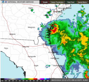
A low pressure system designated as Invest 92L was dropping heavy rain near the coast of Georgia on Saturday morning.

The center of the low pressure system was near Brunswick, Georgia.  There was a well defined center of circulation evident on the U.S. National Weather Service radar at Jacksonville, Florida.  The center of circulation was moving slowly near the coast of Georgia.  The heaviest rain was falling in a ring that wrapped around the eastern side of the center of Invest 92L.  Other bands of rain were over the Atlantic Ocean.

The low pressure system is forecast to move slowly inland over eastern Georgia.  Heavy rain could fall over areas near the coast as Invest 92L moves inland.  Heavy rain could cause flooding in some locations.

Elsewhere, a large low pressure system formed over the southwestern Gulf of Mexico near the area where Tropical Storm Alberto formed.  The low pressure system has been designated as Invest 93L.  At 8:00 a.m. EDT on Saturday the center of Invest 93L was located at latitude 21.0°N and longitude 95.7°W which put it about 125 miles (200 km) east-southeast of Tampico, Mexico.  The low pressure system was moving toward the northwest at 13 m.p.h. (21 km/h).  The maximum sustained wind speed was 35 m.p.h. (55 km/h) and there were wind gusts to 45 m.p.h. (75 km/h).  The minimum surface pressure was 1005 mb.

Invest 93L will move through an environment somewhat favorable for the formation of a tropical cyclone during the next 24 hours.  Invest 93L will move over water where the Sea Surface Temperatures are near 30°C.  It will move under the southeastern part of an upper level ridge that stretches from Baja California to the Great Lakes.  The ridge will produce northeasterly winds that will blow toward the top of the low pressure system.  Those winds will cause moderate vertical wind shear.  The wind shear will inhibit intensification, but the shear may not be strong enough to prevent Invest 93L from developing into a tropical cyclone.  The U.S. National Hurricane Center is indicating that the probability is 50% that Invest 93L develops into a tropical cyclone.

The low pressure system designated as Invest 93L will move around the southern side of a large high pressure system over the eastern U.S.  The high pressure system will steer Invest 93L toward the west-northwest during the next 24 hours.  On its anticipated track, Invest 93L will approach the coast of Mexico near Tampico on Sunday.

The low pressure system designated as Invest 93L will drop heavy rain over some of the same areas where Tropical Storm Alberto dropped heavy rain.  Invest 93L is very likely to cause major flash floods in parts of northern Mexico.

A U.S. Air Force Reserve Hurricane Hunter aircraft is scheduled to investigate the low pressure system designated as Invest 93L later today, if necessary.

Tropical Storm Alberto Brings Wind and Rain to Northern Mexico

Tropical Storm Alberto brought wind and rain to northern Mexico on Thursday morning.  At 8:00 a.m. EDT on Thursday the center of Tropical Storm Alberto was located at latitude 22.3°N and longitude 98.3°W which put it about 25 miles (40 km) west of Tampico, Mexico and about 255 miles (410 km) south of Brownsville, Texas.  Alberto was moving toward the west at 13 m.p.h. (20 km/h).  The maximum sustained wind speed was 45 m.p.h. (75 km/h) and there were wind gusts to 60 m.p.h. (95 km/h).  The minimum surface pressure was 997 mb.

A Tropical Storm Warning was in effect for the portion of the coast from the Mouth of the Rio Grande River to Tecolutla, Mexico.  The Tropical Storm Warning included Tampico, Mexico.

The center of Tropical Storm Alberto made landfall on the coast of Mexico near Tampico on Thursday morning.  The strongest winds were occurring near the center of Alberto’s circulation.  The distribution of winds in Tropical Storm Alberto was still asymmetrical at the time of landfall.  The circulation around the northern side of Alberto’s circulation was interacting with the southern part of a strong high pressure system over the eastern U.S.  The interaction of the two pressure systems was causing a large area of tropical storm force winds in the northern side of Tropical Storm Alberto.  Winds to tropical storm force extended out 275 miles (445 km) in the northern side of Alberto’s circulation.  Winds to tropical storm force extended out 70 miles (110 km) in the southern half of Alberto.

Tropical Storm Alberto will move around the southern side of a strong high pressure system over the eastern U.S.  The high pressure system will steer Alberto toward the west during the next 24 hours.  On its anticipated track, Tropical Storm Alberto will move steadily inland over northern Mexico.

Tropical Storm Alberto will weaken as it moves farther inland over northern Mexico.  Alberto will continue to produce gusty winds along the coast of Texas and northern Mexico during the next few hours.  Tropical Storm Alberto will also drop heavy rain on parts of northern Mexico and southern Texas.   Up to an additional 5 inches (125 mm) of rain could fall on parts of south Texas.  Flood Watches are in effect for parts of South Texas.  Up to an additional 16 inches (400 mm) of rain could fall on parts of northern Mexico where the winds blow the air up the slopes of mountains.  Heavy rain is likely to cause flash floods in some locations.  The heaviest rain is likely to fall in Tamaulipas.

Tropical Storm Alberto Strengthens Near Mexico

Tropical Storm Alberto strengthened on Wednesday evening as it neared the coast of Mexico.  At 11:00 p.m. EDT on Wednesday the center of Tropical Storm Alberto was located at latitude 21.5°N and longitude 95.9°W which put it about 135 miles (220 km) east-southeast of Tampico, Mexico and about 320 miles (510 km) south-southeast of Brownsville, Texas.  Alberto was moving toward the west at 9 m.p.h. (15 km/h).  The maximum sustained wind speed was 50 m.p.h. (80 km/h) and there were wind gusts to 65 m.p.h. (105 km/h).  The minimum surface pressure was 993 mb.

Tropical Storm Alberto was getting stronger on Wednesday evening as it approached the coast of Mexico near Tampico.  Thunderstorms near the center of Alberto’s circulation rose higher into the atmosphere.  A band of thunderstorms wrapped around the southern and eastern side of the center of circulation.  Other bands of showers and thunderstorms were revolving around the center of Tropical Storm Alberto.  Storms near the center of Alberto generated upper level divergence that pumped mass away from the tropical storm.  The removal of mass caused the surface pressure to decrease.

The distribution of winds in Tropical Storm Alberto was still asymmetrical.  The circulation around the northern side of Alberto’s circulation was interacting with the southern part of a strong high pressure system over the eastern U.S.  The interaction of the two pressure systems was causing a large area of tropical storm force winds in the northern side of Tropical Storm Alberto.  Winds to tropical storm force extended out 460 miles (740 km) in the northern side of Alberto’s circulation.  Winds to tropical storm force only extended out 60 miles (95 km) in the southern half of Alberto.

Tropical Storm Alberto will move through an environment favorable for intensification during the next few hours.  Alberto will move over water where the Sea Surface Temperatures are near 30°C.  It will move under the the center of an upper level ridge over the western Gulf of Mexico.  The upper level winds are weak near the center of the ridge and there will be little vertical wind shear.  Tropical Storm Alberto is likely to intensify during the next few hours until the center makes landfall on the coast of Mexico.

Tropical Storm Alberto will move around the southern side of a strong high pressure system over the eastern U.S.  The high pressure system will steer Alberto toward the west during the next 24 hours.  On its anticipated track, Tropical Storm Alberto will make landfall on the coast of northern Mexico early on Thursday.  The center of Alberto will make landfall a little south of Tampico, Mexico.


Tropical Storm Alberto Forms over Western Gulf of Mexico

Tropical Storm Alberto formed over the western Gulf of Mexico on Wednesday morning.  At 11:00 a.m. EDT on Wednesday the center of Tropical Storm Alberto was located at latitude 22.2°N and longitude 95.0°W which put it about 185 miles (300 km) east of Tampico, Mexico and about 295 miles (480 km) south-southeast of Brownsville, Texas.  Alberto was moving toward the west at 9 m.p.h. (15 km/h).   The maximum sustained wind speed was 40 m.p.h. (65 km/h) and there were wind gusts to 50 m.p.h. (80 km/h).  The minimum surface pressure was 995 mb.

More thunderstorms formed near the center of a low pressure system previously designated as Potential Tropical Cyclone One on Wednesday morning.  A U.S. Air Force Reserve Hurricane Hunter reconnaissance aircraft was able to locate a well defined low level center of circulation and the U.S. National Hurricane Center designated the system as Tropical Storm Alberto.

The structure of Tropical Storm Alberto was beginning to resemble a typical tropical storm.  Thunderstorms were forming near the center of Alberto’s circulation.  A band of thunderstorms wrapped around the southern and eastern side of Tropical Storm Alberto.  Other bands of showers and thunderstorms were revolving around the center of Alberto’s circulation.  Storms near the center of Alberto began to generate upper level divergence that pumped mass away from the tropical storm.  The removal of mass was causing the surface pressure to decrease.

Even though Tropical Storm Alberto was starting to look like a tropical storm, the distribution of winds was still asymmetrical.  The circulation around the northern side of Alberto’s circulation was interacting with the southern part of a strong high pressure system over the eastern U.S.  The interaction of the two pressure systems was causing the strongest winds to occur in the northern side of Tropical Storm Alberto.  Winds to tropical storm force extended out 400 miles (645 km) north of the center of Alberto’s circulation.  An anemometer at Garden Banks 783 (KGBK) measured a sustained wind speed of 45 m.p.h. (75 km/h) and wind gusts of 50 m.p.h (80 km/h).  The anemometer is at a height of 58.2 meters above sea level.  The winds in the southern part of Alberto’s circulation were blowing at less than tropical storm force.

Tropical Storm Alberto will move through an environment favorable for intensification during the next 12 hours. Alberto will move over water where the Sea Surface Temperatures are near 30°C.  It will move under the the center of an upper level ridge over the western Gulf of Mexico.  The upper level winds are weak near the center of the ridge and there will be little vertical wind shear.  Tropical Storm Alberto will intensify during the next 12 hours.  Alberto could undergo a brief period of rapid intensification when it approaches the coast of Mexico.

Tropical Storm Alberto will move south of a strong high pressure system over the eastern U.S.  The high pressure system will steer Alberto toward the west during the next 24 hours.  On its anticipated track, Tropical Storm Alberto will make landfall on the coast of northern Mexico on Wednesday night.  The center of Alberto will make landfall near Tampico, Mexico.

Hurricane Grace Hits Yucatan

Hurricane Grace hit the Yucatan Peninsula on Thursday morning. At 8:00 a.m. EDT on Thursday the center of Hurricane Grace was located at latitude 20.1°N and longitude 87.9°W which put it about 45 miles (65 km) south-southeast of Valladolid, Mexico. Grace was moving toward the west at 17 m.p.h. (28 km/h). The maximum sustained wind speed was 75 m.p.h. (120 km/h) and there were wind gusts to 90 m.p.h. (145 km/h). The minimum surface pressure was 989 mb.

A Hurricane Warning was in effect for the portion of the coast from Cancun to Punta Herrero, Mexico. The Hurricane Warning included Cozumel. A Hurricane Watch was in effect for the portion of the coast from Puerto Veracruz to Cabo Rojo,, Mexico. Tropical Storm Warnings were in effect for the portions of the coast from Cancun to Campeche, Mexico and from Punta Herrero to Puerto Costa Maya, Mexico. A Tropical Storm Watch was in effect for the portion of the coast from Cabo Rojo to Puerto de Altamira, Mexico. Tropical Storm Watches were also in effect for the Cuban provinces of Isla de la Juventud and Pinar del Rio.

The center of Hurricane Grace made landfall on the east coast of the Yucatan Peninsula southeast of Tulum on Thursday morning. The maximum sustained wind speed was 80 m.p.h. (130 km/h) at the time of landfall. Winds to hurricane force extended out 35 miles (55 km) from the center of Hurricane Grace. Winds to tropical storm force extended out 140 miles (220 km) from the center of circulation. Grace will produce strong gusty winds over the Yucatan. It will also drop heavy rain and flash floods are likely to occur. Hurricane Grace will weaken gradually back to a tropical storm while it moves across the Yucatan.

Hurricane Grace will move over the southwestern Gulf of Mexico on Thursday night. Grace will move into an environment favorable for intensification when it moves over the Gulf of Mexico. Grace will move over water where the Sea Surface Temperatures are near 30°C. It will move into a region where the upper level winds are weak and there will be little vertical wind shear. Grace is likely to intensify back to a hurricane on Friday.

Hurricane Grace will move south of a subtropical high pressure system that extends over the Gulf of Mexico. The high will steer Grace toward the west during the next several days. On its anticipated track Hurricane Grace will move across the Yucatan Peninsula on Thursday. Grace will move over the southwestern Gulf of Mexico on Thursday night. Hurricane Grace could approach the coast of Mexico between Veracruz and Tampico on Friday night.

Elsewhere, former Tropical Storm Fred was dropping heavy rain over parts of the northeastern U.S. and Tropical Storm Henri was moving west toward the east coast of the U.S.

At 5:00 a.m. EDT on Thursday the center of former Tropical Storm Fred was located at latitude 42.0°N and longitude 76.0°W which put it about 15 miles (25 km) south of Binghamton, New York. Fred was moving toward the east-northeast at 17 m.p.h. (28 km/h). The maximum sustained wind speed was 25 m.p.h. (40 km/h) and there were wind gusts to 35 m.p.h. (55 km/h). The minimum surface pressure was 1011 mb. Flood Watches and Flash Flood Watches were in effect for parts of the northeastern U.S.

At 5:00 a.m. EDT on Thursday the center of Tropical Storm Henri was located at latitude 29.5°N and longitude 69.5°W which put it about 525 miles (845 km) southeast of Cape Hatteras, North Carolina. Henri was moving toward the west at 9 m.p.h. (15 km/h). The maximum sustained wind speed was 70 m.p.h. (110 km/h) and there were wind gusts to 85 m.p.h. (135 km/h). The minimum surface pressure was 995 mb.

TD 22 Forms over Western Gulf of Mexico, Teddy at Cat. 4

Tropical Depression Twentytwo formed over the western Gulf of Mexico on Thursday evening and Hurricane Teddy intensified to Category 4 on the Saffir-Simpson Scale.  At 11:00 p.m. EDT on Thursday the center of Tropical Depression Twentytwo was located at latitude 22.0°N and longitude 94.2°W which put it about 235 miles (380 km) east of Tampico, Mexico.  The depression was moving toward the northeast at 3 m.p.h. (5 km/h).  The maximum sustained wind speed was 35 m.p.h. (55 km/h) and there were wind gusts to 45 m.p.h. (75 km/h).  The minimum surface pressure was 1005 mb.

An Air Force Reserve Hurricane Hunter plane determined that a low level center of circulation was present in a low pressure system over the western Gulf of Mexico on Thursday evening and the National Hurricane Center designated the system as Tropical Depression Twentytwo.  The circulation around the depression was still organizing.  Bands of showers and thunderstorms were developing.  Storms near the center of circulation began to generate upper level divergence which pumped mass away from the tropical depression.

Tropical Depression Twentytwo will move through an environment favorable for intensification during the next several days.  The depression will move over water where the Sea Surface Temperature is near 30°C.  An upper level low near the Rio Grande Valley will produce southerly winds which will blow toward the top of the depression.  Those winds will cause some vertical wind shear.  The shear will inhibit intensification, but the depression is likely to strengthen into a tropical storm.

Tropical Depression Twentytwo will be in an area where the steering currents are weak.  The upper low over the Rio Grande Valley could pull the depression toward the north, but the depression could meander over the western Gulf of Mexico for several days.

Elsewhere, Hurricane Teddy strengthened to Category 4 on the Saffir-Simpson Scale southeast of Bermuda on Thursday evening.  At 11:00 p.m. EDT on Thursday the center of Hurricane Teddy was located at latitude 20.9°N and longitude 54.7°W which put it about 1005 miles (1615 km) southeast of Bermuda.  Teddy was moving toward the northwest at 12 m.p.h. (19 km/h).  The maximum sustained wind speed was 140 m.p.h. (220 km/h) and there were wind gusts to 170 m.p.h. (280 km/h).  The minimum surface pressure was 945 mb.  On its anticipated track Hurricane Teddy could be near Bermuda by Sunday night.