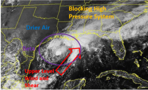
Potential Tropical Cyclone Twentytwo is now unlikely to develop into a tropical depression or a tropical storm. At 10:00 p.m. EST on Friday the center of Potential Tropical Cyclone Twentytwo was located at latitude 20.0°N and longitude 76.5°W which put it about 85 miles (130 km) west of Guantanamo, Cuba. It was moving toward the northeast at 22 m.p.h. (35 km/h). The maximum sustained wind speed was 35 m.p.h. (55 km/h) and there were wind gusts to 45 m.p.h. (75 km/h). The minimum surface pressure was 1006 mb.
A low pressure system over the Caribbean Sea designated as Potential Tropical Cyclone Twentytwo is no longer expected to develop into a tropical depression or a tropical storm. An upper level trough over the Gulf of Mexico is producing strong southwesterly winds that are blowing across the top of the low pressure system. Those winds are causing strong vertical wind shear. The vertical wind shear is preventing the formation of thunderstorms near the center of Potential Tropical Cyclone Twentytwo. Thunderstorms are occurring in bands in the eastern part of the low pressure system. Bands in the western part of the system and near the center of circulation consist of showers and lower clouds.
Potential Tropical Cyclone Twentytwo will move through an environment unfavorable for development of a tropical cyclone during the next 36 hours. The low pressure system will move over water where the Sea Surface Temperatures are near 29°C. However, the upper level trough over the Gulf of Mexico will continue to cause strong vertical wind shear. The vertical wind shear is likely to continue to prevent the formation of a tropical depression or a tropical storm. Potential Tropical Cyclone Twentytwo could merge with a cold front off the east coast of the U.S. during the weekend.
The upper level trough over the Gulf of Mexico will steer Potential Tropical Cyclone Twentytwo toward the northeast during the next 36 hours. On its anticipated track, Potential Tropical Cyclone Twentytwo will move across eastern Cuba and the Southeastern Bahamas on Saturday. The low pressure system will bring gusty winds and locally heavy rain to eastern Cuba, Haiti, and the Dominican Republic. Heavy rain could cause flash floods in parts of Haiti and the Dominican Republic.

