
Tropical Storm Beta was in a holding pattern on Saturday afternoon. At 5:00 p.m. EDT on Saturday the center of Tropical Storm Beta was located at latitude 26.6°N and longitude 92.4°which put it about 320 miles (510 km) east-southeast of Corpus Christi, Texas. Beta was stationary. The maximum sustained wind speed was 60 m.p.h. (95 km/h) and there were wind gusts to 75 m.p.h. (120 km/h). The minimum surface pressure was 994 mb.
A Hurricane Watch was in effect for the portion of the coast from Port Aransas to High Island, Texas. A Tropical Storm Warning was in effect for the portion of the coast from Port Aransas to Intracoastal City, Louisiana. Tropical Storm Watches were in effect for the portions of the coast from the Mouth of the Rio Grande River to Port Aransas and from Intracoastal City to Morgan City, Louisiana.
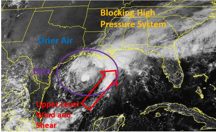
The intensity of Tropical Storm Beta held steady and it moved little on Saturday afternoon. An upper level trough over Texas produced southwesterly winds which blew across the top of Tropical Storm Beta. Those winds caused strong vertical wind shear and they blew the tops off thunderstorms near the center of Beta on Saturday morning. The shear may have decreased later because new thunderstorms formed near the center of circulation on Saturday afternoon. A reconnaissance flight found that the winds around Tropical Storm Beta had maintained their speed. Winds to tropical storm force extended out 175 miles (280 km) on the northern side of Beta. Tropical storm force winds only extended out 50 miles (80 km) in the southern half of the circulation.
Tropical Storm Beta will move through an environment somewhat favorable for intensification during the next 36 hours. Beta will move over water where the Sea Surface Temperature is near 30°C. The upper level trough over Texas is forecast to weaken and if that happens, then the vertical wind shear will decrease. There is drier air over Texas and Tropical Storm Beta could pull some of that air into the southern part of the circulation. Beta could strengthen on Sunday if the wind shear decreases. However, if Tropical Storm Beta remains stationary for too long, its winds will mix cooler water to the surface, which would inhibit intensification.
A large cool high pressure system is over the eastern U.S. The high blocked the northward movement of Beta, which is why the tropical storm became stationary. The high pressure system will move slowly eastward during the next few days. As the high moves east, it will steer Tropical Storm Beta slowly toward the west-northwest. On its anticipated track Tropical Storm Beta could approach the Central Texas coast on Monday. Beta could be a hurricane when it approaches the coast.
The figure below shows the factors affecting Tropical Storm Beta on Saturday afternoon.
Elsewhere, Hurricane Teddy continued to move in the direction of Bermuda. At 5:00 p.m. EDT on Saturday the center of Hurricane Teddy was located at latitude 26.7°N and longitude 60.2°W which put it about 475 miles (765 km) southeast of Bermuda. Teddy was moving toward the northwest at 13 m.p.h. (20 km/h). The maximum sustained wind speed was 120 m.p.h. (195 km/h) and there were wind gusts to 140 m.p.h. (220 km/h). The minimum surface pressure was 958 mb. A Tropical Storm Warning was in effect for Bermuda.