
Tag Archives: Destin

Hurricane Isaias Hits Northwest Florida

Hurricane Isaias hit Northwest Florida on Friday evening.  At 11:00 p.m. EDT on Friday the center of Hurricane Isaias was located at latitude 30.8°N and longitude 86.5°W which put the center about 45 miles (75 km) east-northeast of Pensacola, Florida.  Isaias was moving toward the north at 20 m.p.h. (32 km/h).  The maximum sustained wind speed was 90 m.p.h. (145 km/h) and there were wind gusts to 105 m.p.h. (165 km/h).  The minimum surface pressure was 982 mb.

A Hurricane Warning is in effect for the portion of the coast from the Mississippi/Alabama border to the Bay County/Gulf County line in Florida.

A Tropical Storm Warning is in effect for the portion of the coast from the Bay County/Gulf County line to the Aucilla River in Florida.

The center of Hurricane Isaias made landfall near Destin, Florida on Friday evening.
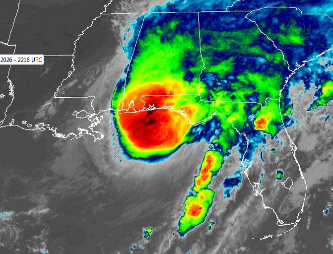
Hurricane Isaias was a Category 2 hurricane on the Saffir-Simpson Scale at the time of landfall.  The maximum sustained wind speed was 105 m.p.h. (165 km/h) when the center of Isaias made landfall.  The Hurricane Intensity Index (HII) was 17.8.  The Hurricane Size Index (HSI) was 14.6 and the Hurricane Wind Intensity Size Index (HWISI) was 32.4.

An upper level low that is over Mississippi will steer Hurricane Isaias toward the north during the next 24 hours.  On its anticipated track, Hurricane Isaias will move inland over Alabama on Saturday.

Hurricane Isaias will continue to bring strong winds to northwest Florida during the next few hours.  Even though Hurricane Isaias will weaken to a tropical storm by Saturday morning, Isaias will bring strong winds and heavy rain to Alabama on Saturday.

Flood Watches are in effect for parts of Alabama.

There are reports of over 400,000 customers without electricity in Florida.  There are also reports of over 200,000 customers without electricity in Alabama.

There are also reports of flooding due to a storm surge along parts of the coast of Northwest Florida.

Low Pressure System Moves Along Northern Gulf Coast

A low pressure system designated as Invest 93L moved along the northern Gulf Coast on Wednesday.  At 2:00 p.m. EDT on Wednesday the center of a low pressure system designated as Invest 93L was located at latitude 30.1°N and longitude 85.9°W which put the center about 30 miles (50 km) southeast of Destin, Florida.  Invest 93L was moving toward the west at 12 m.p.h. (19 km/h).  The maximum sustained wind speed was 30 m.p.h. (50 km/h) and there were wind gusts to 40 m.p.h. (65 km/h).  The minimum surface pressure was 1012 mb.

The center of a low pressure system designated as Invest 93L moved along the northern Gulf Coast on Wednesday.  The distribution of thunderstorms in Invest 93L continued to be asymmetrical.  Thunderstorms were occurring in bands in the southwestern quadrant of the low pressure system.  Much of the heavier rain was falling over the Gulf of Mexico.  Bands in the other parts of Invest 93L consisted primarily of showers and lower clouds.

The low pressure system designated as Invest 93L will move around the southern side of a high pressure system over the southeastern U.S.  The high pressure system will steer Invest 93L toward the west during the next 24 hours.  On its anticipated track, Invest 93L will move toward southern Louisiana.

Invest 93L will move through an environment marginally favorable for the development of a tropical cyclone during the next 24 hours.  Invest 93L will move over water where where the Sea Surface Temperatures are near 30°C.  It will move under the southern part of an upper level ridge over the southeastern U.S.  The upper level ridge will produce northeasterly winds that would blow toward the top of Invest 93L.  Those winds will cause moderate vertical wind shear. The vertical wind shear will inhibit the development of a tropical cyclone.  However, the wind shear might not be enough to prevent Invest 93L from developing into a tropical depression, if the center remains over water.

Invest 93L could drop heavy rain over parts of southern Mississippi and southern Louisiana.

Flood Watches are in effect for parts of southern Mississippi and southern Louisiana.