Tag Archives: Beryl

Beryl Brings Rain and Storms to Central U.S.

Former Hurricane Beryl is bringing rain and thunderstorms to parts of the central U.S. on Tuesday.  Beryl weakened to a tropical depression on Monday night as it moved farther inland. At 11:00 a.m. EDT on Tuesday the center of Tropical Depression Beryl was located at latitude 35.8°N and longitude 91.2°W which put the center about 35 miles (55 km) west-southwest of Jonesboro, Arkansas.  Beryl was moving toward the northeast at 25 m.p.h. (40 km/h).  The maximum sustained wind speed was 30 m.p.h. (50 km/h) and there were wind gusts to 40 m.p.h. (65 km/h).  The minimum surface pressure was 1004 mb.

A day after Hurricane Beryl hit the coast of Texas and caused over 2.5 million customers to lose electricity, Beryl is bringing rain and thunderstorms to parts of the central U.S.  The center of the surface circulation of former Hurricane Beryl is located over northeastern Arkansas.  Thunderstorms are starting to form in bands over Alabama, western Tennessee and western Kentucky.  Steady light to moderate rain is falling over Missouri, central Illinois and central Indiana.

An upper level trough over the central U.S. will steer Tropical Depression Beryl toward the northeast during the next 24 hours.  On its anticipated track the center of Beryl’s circulation will move from northeastern Arkansas to northern Indiana.

Tropical Depression Beryl will drop heavy rain over parts of the Middle Mississippi River Valley and Lower Great Lakes.  The heaviest rain is likely to fall in southeastern Missouri, central and eastern Illinois, northwestern Indiana and southern Michigan.

Flood Watches are in effect for northern Arkansas, central and southern Missouri, Illinois, far western Kentucky, northern Indiana and southern Michigan.

The circulation around the eastern side of Tropical Depression Beryl could generate enough low level wind shear for rotation in thunderstorms.  Some thunderstorms could produce tornadoes.  The U.S. National Weather Service Storm Prediction Center (SPC) is indicating an Enhanced Risk of Severe Weather for the area stretching from Cincinnati, Ohio through Louisville, Kentucky to Evansville, Indiana.

Hurricane Beryl Brings Wind and Rain to East Texas

Hurricane Beryl brought wind and rain to east Texas on Monday morning.  Beryl weakened to a tropical storm late on Monday morning.  At 11:00 a.m. EDT on Monday the center of Tropical Storm Beryl was located at latitude 29.8°N and longitude 95.7°W which put the center about 20 miles (30 km) west-northwest of Houston, Texas.  Beryl was moving toward the north at 13 m.p.h. (20 km/h).  The maximum sustained wind speed was 70 m.p.h. (110 km/h) and there were wind gusts to 85 m.p.h. (135 km/h).  The minimum surface pressure was 984 mb.

A Tropical Storm Warning was in effect for the portion of the coast from Port O’Connor to Sabine Pass, Texas.

A Storm Surge Warning was in effect for the portion of the coast from Port O’Connor to Sabine Pass, Texas.

The center of Hurricane Beryl made landfall on the coast of Texas at Matagorda early on Monday morning.  Beryl was intensifying at the time of landfall.  The maximum sustained wind speed in Hurricane Beryl was 80 m.p.h. (130 km/h) at the time of landfall.  A circular eye with a diameter of 32 miles (52 km) was present at the center of Beryl’s circulation at the time of landfall.

The strongest winds in Hurricane Beryl were occurring in the eastern half of Beryl’s circulation.  At the time of landfall winds to hurricane force extended out 45 miles (75 km) in the eastern side of Beryl.  Winds to tropical storm force extended out 115 miles (185 km) from the center of Hurricane Beryl.

The Hurricane Intensity Index (HII) for Hurricane Beryl at the time of landfall was 11.5.  The Hurricane Size Index (HSI) was 10.3 and the Hurricane Wind Intensity Size Index (HWISI) was 21.8.  Hurricane Beryl was not quite as strong as Hurricane Dolly was when Dolly hit South Texas in 2008.  Beryl was a little smaller that Dolly was.

The eye of Hurricane Beryl passed directly over Matagorda, Texas.  A weather station at Matagorda, Texas (EMAT2) reported a sustained wind speed of 68 m.p.h. (110 km/h) when the northern part of the eyewall passed over the station.  The station also reported a wind gust of 86 m.p.h. (139 km/h).  The station reported a surface pressure of 980 mb when the eye of Hurricane Beryl was over it.
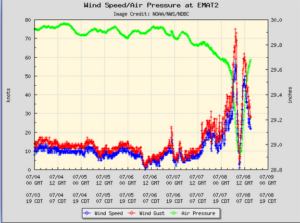
A weather station at Freeport, Texas (FPST2) reported a sustained wind speed of 75 m.p.h. (120 km/h) and a wind gust of 87 m.p.h. (141 km/h).

A weather station at the North Jetty Entrance to Galveston Bay (GNJT2) reported a sustained wind speed of 72 m.p.h. (117 km/h) and a wind gust of 82 m.p.h. (132 km/h).

After Hurricane Beryl made landfall on the coast of Texas, the center of Beryl’s circulation passed just to the west of Houston.  The eastern side of Beryl’s eyewall passed over Houston.  Beryl brought strong winds and heavy rain to the area around Houston.

A weather station at Houston Hobby Airport reported a sustained wind speed of 58 m.p.h. (94 km/h) and a wind gust of 84 m.p.h. 135 km/h).  The weather station also reported 4.15 inches (105 mm) of rain.

A weather station at Houston Intercontinental Airport reported a sustained wind speed of 59 m.p.h. (95 km/h) and a wind gust of 82 m.p.h. (132 km/h).  The station also reported 4.31 inches of rain.

The strong winds in Hurricane Beryl caused widespread electricity outages in east Texas.  There were reports of 2.5 million customers without electricity.

The strong winds in Hurricane Beryl caused a storm surge along the coast of Texas.  There were reports of water level rises of 5 feet (1.5 meters) at multiple locations along the coast.

Tropical Storm Beryl will move under the southeastern part of an upper level trough over the Central U.S.  The upper level trough will steer Beryl toward the north-northeast during the next 12 hours.  On its anticipated track, Tropical Storm Beryl will move over northeast Texas later today.  The upper level trough will steer Beryl toward the northeast on Tuesday.  Beryl will move over Arkansas on Tuesday morning.

Tropical Storm Beryl will continue to weaken gradually as it moves farther inland.  Beryl will continue to produce strong winds over east Texas during the next few hours.  Widespread minor wind damage is likely to occur.  There are also likely to be additional electricity outages.  Tropical Storm Beryl could drop up to 8 inches (200 mm) of rain on some locations.   Heavy rain is likely to cause flooding.  Flood Watches are in effect for parts of eastern Texas.  Flood Watches are also in effect for parts of southeastern Oklahoma, southwestern Arkansas and northwestern Louisiana.  Tropical Storm Beryl will continue to cause a storm surge of up to 5 feet (1.5 meters) along the coast until the wind speeds decrease when Beryl moves farther away.


Hurricane Beryl Makes Landfall in Texas

Hurricane Beryl made landfall on the coast of Texas at Matagorda early on Monday morning.  At 5:00 a.m. EDT on Monday the center of Hurricane Beryl was located at latitude 28.6°N and longitude 96.0°W which put the center at Matagorda, Texas.  Beryl was moving toward the north at 12 m.p.h. (19 km/h).  The maximum sustained wind speed was 80 m.p.h. (130 km/h) and there were wind gusts to 100 m.p.h. (160 km/h).  The minimum surface pressure was 979 mb.

A Hurricane Warning was in effect for the portion of the coast from Mesquite Bay to Port Bolivar, Texas.

A Tropical Storm Warning was in effect for the portion of the coast from Port Bolivar to Sabine Pass, Texas.

A Storm Surge Warning was in effect for the portion of the coast from Mesquite Bay to Sabine Pass, Texas.

The center of Hurricane Beryl made landfall on the coast of Texas at Matagorda early on Monday morning.  Beryl was intensifying at the time of landfall.  A circular eye with a diameter of 32 miles (52 km) was present at the center of Beryl’s circulation.  The eye of Hurricane Beryl passed directly over Matagorda Texas.  The eye was surrounded by a ring of strong thunderstorms and the strongest winds were occurring in that ring of storms.  Bands of showers and thunderstorms were revolving around the center of Hurricane Beryl.

The strongest winds in Hurricane Beryl were occurring in the eastern half of Beryl’s circulation.  Winds to hurricane force extended out 45 miles (75 km) in the eastern side of Beryl.  Winds to tropical storm force extended out 115 miles (185 km) from the center of Hurricane Beryl.

The Hurricane Intensity Index (HII) for Hurricane Beryl was 11.5.  The Hurricane Size Index (HSI) was 10.3 and the Hurricane Wind Intensity Size Index (HWISI) was 21.8.  Hurricane Beryl was not quite as strong as Hurricane Dolly was when Dolly hit South Texas in 2008.  Beryl was a little smaller that Dolly was.

A weather station at Matagorda, Texas (EMAT2) reported a sustained wind speed of 68 m.p.h. (110 km/h) when the northern part of the eyewall passed over the station.  The station also reported a wind gust of 86 m.p.h. (139 km/h).  The station reported a surface pressure of 980 mb when the eye of Hurricane Beryl was over it.

A weather station at Freeport, Texas (FPST2) reported a sustained wind speed of 71 m.p.h. (115 km/h) and a wind gust of 86 m.p.h. (139 km/h).

Heavy rain was falling over parts of eastern Texas.  Heavy rain was falling in Houston and Galveston.

Hurricane Beryl will move around the western part of a high pressure system over the southeastern U.S.  The high pressure system will steer Beryl toward the north during the next 12 hours. Hurricane Beryl will start to move toward the northeast on Monday night.  On its anticipated track, the center of Hurricane Beryl will pass over Bay City, Texas.  The center of Beryl will pass just to the west of Houston in a few hours.

Hurricane Beryl will start to weaken gradually as the center of Beryl’s circulation moves farther inland.  Beryl will bring strong winds and heavy rain to parts of eastern Texas.  Hurricane Beryl will be capable of causing regional minor damage.  The strongest winds will be in the eastern side of Hurricane Beryl.  Beryl will bring strong winds to Galveston and Houston.  The strong winds are likely to cause electricity outages.

Hurricane Beryl could drop up to 10 inches (250 mm) of rain on some locations.   Heavy rain is likely to cause flooding.  Flood Watches are in effect for parts of eastern Texas.  Flood Watches are also in effect for parts of southeastern Oklahoma, southwestern Arkansas and northwestern Louisiana.  Hurricane Beryl could also cause a storm surge of up to 10 feet (3 meters) where the wind pushes water toward the coast.


Beryl Strengthens Back to a Hurricane

Former Tropical Storm Beryl strengthened back to a hurricane on Sunday night as it neared the coast of Texas.  At 12:00 a.m. EDT on Monday the center of Hurricane Beryl was located at latitude 27.7°N and longitude 95.7°W which put the center about 65 miles (105 km) south-southeast of Matagorda, Texas.   Beryl was moving toward the north-northwest at 10 m.p.h. (16 km/h).   The maximum sustained wind speed was 75 m.p.h. (120 km/h) and there were wind gusts to 90 m.p.h. (145 km/h).   The minimum surface pressure was 985 mb.

A Hurricane Warning was in effect for the portion of the coast from Mesquite Bay to Port Bolivar, Texas.

A Tropical Storm Warning was in effect for the portion of the coast from Mesquite Bay to Port Mansfield, Texas.  A Tropical Storm Warning was also in effect for the portion of the coast from Port Bolivar to Sabine Pass, Texas.

A Storm Surge Warning was in effect for the portion of the coast from Mesquite Bay to Sabine Pass, Texas.

Former Tropical Storm Beryl strengthened back to a hurricane as it neared the coast of Texas on Sunday night.  Beryl strengthened slowly but steadily on Sunday night.  The inner end of a rainband wrapped around the center of Beryl’s circulation.  A circular eye with a diameter of 45 miles (75 km) was at the center of Hurricane Beryl.  The eye was surrounded by a broken ring of thunderstorms and the strongest winds were occurring in that ring of storms.  Bands of showers and thunderstorms revolved around the center of Hurricane Beryl.  Storms near the center of circulation generated upper level divergence that pumped mass away from the hurricane.  The removal of mass caused the surface pressure to decrease slowly.

The circulation around Hurricane Beryl became more symmetrical on Sunday.  Winds to tropical storm force extended out 115 miles (185 km) from the center of Beryl’s circulation.

Hurricane Beryl will move through an environment that will be favorable for intensification during the next few hours.  Beryl will move over water where the Sea Surface Temperatures are near 30°C.  It will move under an upper level ridge over the Gulf of Mexico.  The upper level winds are weak in the ridge and there will be be little vertical wind shear.  Hurricane Beryl will continue to intensify during the next few hours.  There could be a brief period of more rapid intensification if an inner core with an eye and and eyewall develops fully.

Hurricane Beryl will move around the southwestern part of a high pressure system over the southeastern U.S.   The high pressure system will steer Beryl toward the north during the next 24 hours.   On its anticipated track, Hurricane Beryl will make landfall on the coast of Texas on Monday.  The center of Beryl’s circulation will make landfall between Matagorda and Galveston, Texas.

Hurricane Beryl will bring strong winds and heavy rain to parts of eastern Texas.  The strong winds are likely to cause power outages.  Beryl could bring strong winds to Galveston and Houston.  Up to 10 inches (250 mm) of rain could fall in some locations.  Heavy rain is likely to cause flooding.  Flood Watches are in effect for parts of eastern Texas.  Flood Watches are also in effect for parts of southeastern Oklahoma, southwestern Arkansas and northwestern Louisiana.  Hurricane Beryl could also cause a storm surge of up to 10 feet (3 meters) where the wind pushes water toward the coast.


Tropical Storm Beryl Approaches Texas Coast

Tropical Storm Beryl was approaching the coast of Texas on Sunday night.  At 11:00 p.m. EDT on Sunday the center of Tropical Storm Beryl was located at latitude 27.6°N and longitude 95.6°W which put the center about 75 miles (120 km) south-southeast of Matagorda, Texas.  Beryl was moving toward the north-northwest at 10 m.p.h. (16 km/h).  The maximum sustained wind speed was 70 m.p.h. (120 km/h) and there were wind gusts to 85 m.p.h. (135 km/h).  The minimum surface pressure was 986 mb.

A Hurricane Warning was in effect for the portion of the coast from Mesquite Bay to Port Bolivar, Texas.

A Tropical Storm Warning was in effect for the portion of the coast from Mesquite Bay to Port Mansfield, Texas.  A Tropical Storm Warning was also in effect for the portion of the coast from Port Bolivar to Sabine Pass, Texas.

A Storm Surge Warning was in effect for the portion of the coast from Mesquite Bay to Sabine Pass, Texas.

Tropical Storm Beryl was strengthening slowly but steadily on Sunday evening.  The inner end of a rainband wrapped around the center of Beryl’s circulation.  A circular eye with a diameter of 45 miles (75 km) was at the center of Tropical Storm Beryl.  The eye was surrounded by a broken ring of thunderstorms and the strongest winds were occurring in that ring of storms.  Bands of showers and thunderstorms revolved around the center to Tropical Storm Beryl.  Storms near the center of circulation generated upper level divergence that pumped mass away from the tropical storm.  The removal of mass caused the surface pressure to decrease slowly.

The circulation around Tropical Storm Beryl became more symmetrical on Sunday.  Winds to tropical storm force extended out 115 miles (185 km) from the center of Beryl’s circulation.

Tropical Storm Beryl will move through an environment that will be favorable for intensification during the next few hours.  Beryl will move over water where the Sea Surface Temperatures are near 30°C.   It will move under an upper level ridge over the Gulf of Mexico.  The upper level winds are weak in the ridge and there will be be little vertical wind shear.  Tropical Storm Beryl will continue to intensify during the next few hours.   Beryl is very likely to strengthen to a hurricane.  There could be a brief period of more rapid intensification if an inner core with an eye and and eyewall develops fully.

Tropical Storm Beryl will move around the southwestern part of a high pressure system over the southeastern U.S.  The high pressure system will steer Beryl toward the north during the next 24 hours.  On its anticipated track, the of Tropical Storm Beryl will make landfall on the coast of Texas on Monday.

Tropical Storm Beryl is very likely to be a hurricane when it reaches the coast of Texas.  Beryl will bring strong winds and heavy rain to parts of eastern Texas.  The strong winds are likely to cause power outages.  Up to 10 inches (250 mm) of rain could fall in some locations.  Heavy rain is likely to cause flooding.  Flood Watches were in effect for parts of eastern Texas.  Tropical Storm Beryl could also cause a storm surge of up to 10 feet (3 meters) where the wind pushes water toward the coast.


Tropical Storm Beryl Churns Toward Texas

Tropical Storm Beryl churned toward the coast of Texas on Saturday.  At 11:00 p.m. EDT on Saturday the center of Tropical Storm Beryl was located at latitude 24.7°N and longitude 94.0°W which put the center about 300 miles (485 km) southeast of Corpus Christi, Texas.  Beryl was moving toward the northwest at 13 m.p.h. (20 km/h).  The maximum sustained wind speed was 60 m.p.h. (95 km/h) and there were wind gusts to 75 m.p.h. (120 km/h).  The minimum surface pressure was 993 mb.

A Hurricane Warning was in effect for the portion of the coast from Baffin Bay to Sargent, Texas.

Hurricane Watches were in effect from the portions of the coast from Baffin Bay, Texas to the Mouth of the Rio Grande River and from Sargent to San Luis Pass, Texas.

A Tropical Storm Warning was in effect for the portion of the coast from Baffin Bay, Texas to the Mouth of the Rio Grande River.  A Tropical Storm Warning was in effect for the portion of the coast from Sargent to High Island, Texas.  A Tropical Storm Warning was also in effect for the portion of the coast from the Mouth of the Rio Grande River to Barra el Mezquital, Mexico.

A Storm Surge Warning was in effect for the portion of the coast from the north end of Padre Island to High Island, Texas.

Storm Surge Watches were in effect for the portion of the coast from the Mouth of the Rio Grande River to the north end of Padre Island, Texas and from High Island to Sabine Pass, Texas.

The structure of Tropical Storm Beryl did not change a lot on Saturday.  The inner end of a rainband wrapped around the western side of the center of Beryl’s circulation.  Bands of showers and thunderstorms revolved around the center to Tropical Storm Beryl.  Storms near the center of circulation generated upper level divergence that pumped mass away from the tropical storm.  The removal of mass caused the surface pressure to decrease slowly.

The size of the circulation around Tropical Storm Beryl also did not change much on Saturday.   Winds to tropical storm force extended out 125 miles (200 km) in the northern half of Beryl’s circulation.  Winds to tropical storm force only extended out 45 miles in the southern half of Tropical Storm Beryl.

Tropical Storm Beryl will move into an environment that will become more favorable for intensification during the next 24 hours . Beryl will move over water where the Sea Surface Temperatures are near 30°C.  It will move under the northern part of an upper level low over the western Gulf of Mexico.  The upper level low will produce southeasterly winds that will blow toward the top of Beryl’s circulation.  The winds in the lower levels of the atmosphere will also blow from the southeast.  Since the winds in the upper and lower levels will blow from the southeast, there will be little vertical wind shear.  Tropical Storm Beryl will intensify during the next 24 hours.  Beryl is likely to strengthen to a hurricane.  Beryl could intensify rapidly if an inner core with an eye and and eyewall develops.  There is a chance Beryl could intensify to a major hurricane before it reaches the coast.

Tropical Storm Beryl will move around the southwestern part of a high pressure system over the southeastern U.S.  The high pressure system will steer Beryl toward the northwest during the next 24 hours.  On its anticipated track, Tropical Storm Beryl will approach the coast of Texas on Sunday night.

Tropical Storm Beryl is likely to be a hurricane when it reaches the coast of Texas.  Beryl will bring strong winds and heavy rain to parts of eastern Texas.  Up to 10 inches (250 mm) of rain could fall in some locations.  Heavy rain is likely to cause flooding.  Flood Watches were in effect for parts of eastern Texas.  Tropical Storm Beryl could also cause a storm surge of up to 10 feet (3 meters) where the wind pushes water toward the coast.

Tropical Storm Beryl Moves Toward Texas

Tropical Storm Beryl moved toward Texas on Saturday morning.  At 11:00 a.m. EDT on Saturday the center of Tropical Storm Beryl was located at latitude 23.0°N and longitude 92.3°W which put the center about 460 miles (740 km) southeast of Corpus Christi, Texas.  Beryl was moving toward the west-northwest at 12 m.p.h. (19 km/h).  The maximum sustained wind speed was 60 m.p.h. (95 km/h) and there were wind gusts to 75 m.p.h. (120 km/h).  The minimum surface pressure was 997 mb.

A Hurricane Watch was in effect from the portion of the coast from the Mouth of the Rio Grande River to San Luis Pass, Texas.  The Hurricane Watch included Corpus Christi.

A Tropical Storm Warning was in effect for the portion of the coast from Baffin Bay, Texas to the Mouth of the Rio Grande River.  A Tropical Storm Warning was also in effect for the portion of the coast from the Mouth of the Rio Grande River to Barra el Mezquital, Mexico.

A Storm Surge Watch was in effect for the portion of the coast from the Mouth of the Rio Grande River to High Island, Texas.

Tropical Storm Beryl exhibited more organization on Saturday morning.  More thunderstorms formed near the center of Beryl’s circulation.  The inner end of a band of thunderstorms wrapped around the center of circulation.  Storms near the center generated more upper level divergence that pumped mass away from the tropical storm.  The removal of more mass caused the surface pressure to start to decrease again.  More thunderstorms were also forming in bands revolving around the center of Beryl’s circulation.

The winds at the surface were just starting to be affected by the new thunderstorms in Tropical Storm Beryl.  Winds to tropical storm force extended out 125 miles (200 km) in the northern half of Beryl’s circulation.  Winds to tropical storm force only extended out 45 miles in the southern half of Tropical Storm Beryl.

Beryl will move into an environment that will become more favorable for intensification during the next 24 hours.  Beryl will move over water where the Sea Surface Temperatures are near 29°C.  It will move under the northeastern part of an upper level low over the western Gulf of Mexico.  The upper level low will produce southeasterly winds that will blow toward the top of Beryl’s circulation.  Those winds will cause some vertical wind shear, but the wind shear is likely to decrease by Sunday.  The wind shear will inhibit intensification, but the shear will not be enough to prevent strengthening.  Tropical Storm Beryl will intensify during the next 24 hours.  Beryl is likely to strengthen to a hurricane.  Beryl could intensify more rapidly when it approaches the Texas coast on Sunday.  There is a chance Beryl could intensify to a major hurricane by the end of the weekend.

Tropical Storm Beryl will move around the southwestern part of a high pressure system over the southeastern U.S.  The high pressure system will steer Beryl toward the northwest during the next 24 hours.  On its anticipated track, Tropical Storm Beryl will continue to move toward the coast of Texas.  Beryl could approach the coast of Texas on Sunday night.

Tropical Storm Beryl Prompts Hurricane and Storm Surge Watches for Texas

The risk posed by Tropical Storm Beryl prompted the issuance of Hurricane and Storm Watches for a portion of the coast of Texas.  At 5:00 p.m. EDT on Friday the center of Tropical Storm Beryl was located at latitude 21.2°N and longitude 89.2°W which put the center about 35 miles (55 km) east-southwest of Progreso, Mexico.  Beryl was moving toward the west-northwest at 15 m.p.h. (24 km/h).  The maximum sustained wind speed was 65 m.p.h. (105 km/h) and there were wind gusts to 80 m.p.h. (130 km/h).  The minimum surface pressure was 989 mb.

A Hurricane Watch was in effect from the portion of the coast from the Mouth of the Rio Grande River to Sargent, Texas.  The Hurricane Watch included Corpus Christi.  A Hurricane Watch was also in effect for the portion of the coast from the Mouth of the Rio Grande River to Barra el Mezquital, Mexico

A Tropical Storm Warning was in effect for the portion of the coast from Campeche to Cabo Catoche, Mexico.

A Storm Surge Watch was in effect for the portion of the coast from the Mouth of the Rio Grande River to Sargent, Texas.

Former Hurricane Beryl weakened to a tropical storm as it moved across the northern part of the Yucatan Peninsula on Friday.  An eye was no longer detectable on visible satellite images, but the core of Beryl’s circulation appeared to be relatively intact.  Thunderstorms were still occurring near the center of Tropical Storm Beryl.  Bands of showers and thunderstorms were revolving around the center of circulation.  Storms near the center still generated upper level divergence that pumped mass away from the tropical storm.

Winds to tropical storm force extended out 105 miles (165 km/h) from the center of Tropical Storm Beryl.

Tropical Storm Beryl will move around the southwestern part of a high pressure system over the southeastern U.S.  The high pressure system will steer Beryl toward the northwest during the next 24 hours.  On its anticipated track, Tropical Storm Beryl will move toward the coast of Texas.  Beryl could approach the coast of Texas on Sunday night.

Beryl will move into an environment that will become more favorable for intensification during the next 24 hours.  Beryl will move over water where the Sea Surface Temperatures are near 29°C.  It will move under the eastern part of an upper level low over the western Gulf of Mexico.  The upper level low will produce southerly winds that will blow toward the top of Beryl’s circulation.  Those winds will cause some vertical wind shear.  The wind shear will inhibit intensification, but the shear will not be enough to prevent strengthening.  Tropical Storm Beryl is likely to strengthen slowly during the next 24 hours until the inner core of the circulation becomes more organized.  Beryl could intensify more rapidly when it approaches the Texas coast on Sunday.  Tropical Storm Beryl is very likely to intensify back to a hurricane.  There is a chance Beryl could intensify to a major hurricane by the end of the weekend.


Hurricane Beryl Hits the Yucatan

Hurricane Beryl hit the Yucatan Peninsula on Friday morning.  At 8:00 a.m. EDT on Friday the center of Hurricane Beryl was located at latitude 20.4°N and longitude 87.6°W which put the center about 15 miles (25 km) north-northwest of Tulum, Mexico.  Beryl was moving toward the west-northwest at 15 m.p.h. (24 km/h).  The maximum sustained wind speed was 100 m.p.h. (160 km/h) and there were wind gusts to 120 m.p.h. (195 km/h).  The minimum surface pressure was 980 mb.

A Hurricane Warning was in effect for the portion of the coast from Puerto Costa Maya to Cancun, Mexico.  A Hurricane Warning was also in effect for Cozumel.

A Hurricane Watch was in effect for portion of the coast from Cabo Catoche to Cancun, Mexico.  A Hurricane Watch was also in effect for the portion of the coast from Puerto Costa Maya to Chetumal, Mexico.

A Tropical Storm Warning was in effect for the portion of the coast from Campeche to Cancun, Mexico.   A Tropical Storm Warning was also in effect for the portion of the coast from Puerto Costa Maya to Chetumal, Mexico.

The center of Hurricane Beryl made landfall on the coast of Mexico near Tulum on Friday morning.  Beryl was a Category 2 hurricane on the Saffir-Simpson Scale at the time of landfall.  A small circular eye was present at the center of Beryl’s circulation.  The eye was surrounded by a broken ring of thunderstorms and the strongest winds were occurring in that ring of storms.  Bands of thunderstorms were revolving around the core of Hurricane Beryl.  Storms near the core of Beryl’s circulation generated upper level divergence that pumped mass away from the hurricane.

The size of the circulation around Hurricane Beryl was small.  Winds to hurricane force extended out 30 miles (50 km) from the center of Beryl’s circulation.  Winds to tropical storm force extended out 105 miles (165 km) from the center of Hurricane Beryl.

The Hurricane Intensity Index (HII) for Hurricane Beryl was 16.5.  The Hurricane Size Index (HSI) was 9.3 and the Hurricane Wind Intensity Size Index (HWISI) was 25.8.  Hurricane Beryl was similar in size and intensity to Hurricane Idalia when Idalia hit Florida in 2023.

Hurricane Beryl will move around the southern side of a high pressure system that extends over the western Atlantic Ocean and southeastern U.S.  The high pressure system will steer Beryl toward the west-northwest during the next 24 hours.  On its anticipated track, the center of Hurricane Beryl will move across the northern part of the Yucatan Peninsula during the rest of Friday.

Hurricane Beryl will bring strong winds and locally heavy rain to the northern part of the Yucatan Peninsula.  Strong winds and heavy rain will occur in Quintana Roo and Yucatan.  Beryl is capable of causing serious damage.  Heavy rain is likely to cause floods in some locations.  Hurricane Beryl could cause a storm surge of up to 10 feet (3 meters) along the portion of the coast north of Tulum.

Hurricane Beryl will weaken as it moves across the Yucatan Peninsula.  Beryl will likely weaken to a tropical storm while it is over the Yucatan.  Hurricane Beryl will move over the western Gulf of Mexico during the weekend.  Beryl will move into an environment somewhat favorable for intensification when it reaches the Gulf of Mexico.  Beryl will move over water where the Sea Surface Temperatures are near 29°C.  It will move under the eastern part of an upper level low over the western Gulf of Mexico.  The upper level low will produce southerly winds that will blow toward the top of Beryl’s circulation.  Those winds will cause some vertical wind shear.  The wind shear will inhibit intensification, but the shear may not be enough to prevent strengthening.  Beryl could could intensify back to a hurricane when it moves over the Gulf of Mexico.

Hurricane Beryl will move more toward the northwest during the weekend.  Beryl could approach the coast of Texas on Sunday.  Watches may be issued for the coast later on Friday or on Saturday.


Hurricane Beryl Approaches the Yucatan

Hurricane Beryl was approaching the Yucatan Peninsula on Thursday evening.  At 11:00 p.m. EDT on Thursday the center of Hurricane Beryl was located at latitude 19.6°N and longitude 85.5°W which put the center about 135 miles (220 km) east-southeast of Tulum, Mexico.  Beryl was moving toward the west at 16 m.p.h. (26 km/h).  The maximum sustained wind speed was 115 m.p.h. (185 km/h) and there were wind gusts to 135 m.p.h. (220 km/h).  The minimum surface pressure was 964 mb.

A Hurricane Warning was in effect for the portion of the coast from Puerto Costa Maya to Cancun, Mexico.  A Hurricane Warning was also in effect for Cozumel.

A Hurricane Watch was in effect for portion of the coast from Cabo Catoche to Cancun, Mexico.  A Hurricane Watch was also in effect for the portion of the coast from Puerto Costa Maya to Chetumal, Mexico.

A Tropical Storm Warning was in effect for the portion of the coast from Campeche to Cancun, Mexico.   A Tropical Storm Warning was also in effect for the portion of the coast from Puerto Costa Maya to Chetumal, Mexico.

A Tropical Storm Watch was in effect for the portion of the coast from Chetumal, Mexico to Belize City, Belize.

After weakening earlier on Thursday, a U.S. Air Force Reserve Hurricane Hunter aircraft found that Hurricane Beryl had strengthened back to a major hurricane on Thursday evening.  The reconnaissance plane found an eye with a diameter of 14 miles (22 km) was at the center of Beryl’s circulation.  The eye was surrounded by a broken ring of thunderstorms and the strongest winds were occurring in that ring of storms.  Bands of thunderstorms were revolving around the core of Hurricane Beryl.  Storms near the core of Beryl’s circulation generated more upper level divergence that pumped mass away from the hurricane.  The increase in upper level divergence caused the surface pressure to decrease again.

The size of the circulation around Hurricane Beryl decreased on Thursday.  Winds to hurricane force extended out 30 miles (50 km) from the center of Beryl’s circulation.  Winds to tropical storm force extended out 140 miles (225 km) from the center of Hurricane Beryl.

The Hurricane Intensity Index (HII) for Hurricane Beryl was 20.6.  The Hurricane Size Index (HSI) was 9.8 and the Hurricane Wind Intensity Size Index (HWISI) was 30.4.  Hurricane Beryl was similar in size and intensity to Hurricane Sally when Sally hit Alabama in 2020.

Hurricane Beryl will move through an environment that will be somewhat favorable for intensification during the next few hours.  Beryl will move over water where the Sea Surface Temperatures are near 29°C.  It will move under the southeastern part of an upper level low over Gulf of Mexico.  The upper level low will produce westerly winds that will blow toward the top of Beryl’s circulation.  Those winds will cause some vertical wind shear.  The wind shear will inhibit intensification, but the shear may not be enough to prevent strengthening  Hurricane Beryl could intensify during the next few hours.

Hurricane Beryl will move around the southern side of a high pressure system that extends over the western Atlantic Ocean and southeastern U.S.  The high pressure system will steer Beryl toward the west-northwest during the next 24 hours.  On its anticipated track, the center of Hurricane Beryl will reach the Yucatan Peninsula on Friday morning.

Hurricane Beryl will be able to cause regional major damage when it reaches the Yucatan Peninsula.  Beryl will bring strong winds and heavy rain to the Yucatan.  Widespread electricity outages are likely.  Heavy rain is likely to cause floods in some locations.  Hurricane Beryl could also cause a storm surge of up to 10 feet (3 meters) where the wind blows the water toward the coast.