
Tropical Storm Pena was still churning westward over the Central North Pacific Ocean far to the southwest of Hawaii on Wednesday night. At 10:00 p.m. EST on Wednesday the center of Tropical Storm Pena was located at latitude 9.8°N and longitude 170.6°W which put the center about 1160 miles (1865 km) southwest of Honolulu, Hawaii. Pena was moving toward the west at 15 m.p.h. (24 km/h). The maximum sustained wind speed was 45 m.p.h. (75 km/h) and there were wind gusts to 60 m.p.h. (95 km/h). The minimum surface pressure was 1002 mb.
Tropical Storm Pena was showing evidence of weakening on Wednesday evening. Pena was moving into a large mass of drier air that was east of the International Date Line. It was also moving under the eastern side of an upper level trough that was near the International Date Line. The upper level trough was producing southwesterly winds that were blowing toward the top of Pena’s circulation. Those winds were causing moderate vertical wind shear. The drier air and moderate vertical wind shear were causing Tropical Storm Pena to start to weaken.
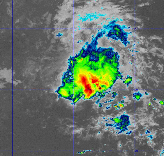
The drier air and moderate vertical wind shear were also beginning to affect the structure of Tropical Storm Pena. Thunderstorms were still occurring in bands in the eastern side of Pena’s circulation. Bands in the western side of Tropical Storm Pena consisted primarily of showers and lower clouds. Storms near the center of Pena generated less upper level divergence that pumped less mass away from the tropical storm. The removal of mass in the upper levels was nearly equal to the convergence of mass in the lower levels of the atmosphere. So, the surface pressure did not change much on Wednesday.
The strongest winds were occurring in bands of thunderstorms in the northeastern part of Tropical Storm Pena. Winds to tropical storm force extended out 115 miles (185 km) in the northeastern quadrant of Pena’s circulation. The winds were blowing at less than tropical storm force in the other parts of Tropical Storm Pena.
Tropical Storm Pena will move through an environment that will be unfavorable for intensification during the next 24 hours. Pena will move over water where the Sea Surface Temperatures are near 29°C. However, the upper level trough near the International Date line will continue to cause moderate vertical wind shear. Tropical Storm Pena will also continue to move through the large mass of drier air that is east of the International Date Line. Tropical Storm Pena is likely to weaken on Thursday because of the moderate vertical wind shear and the drier air.
Tropical Storm Pena will move around the southern side of a high pressure system that is over the Central North Pacific Ocean. The high pressure system will steer Pena toward the west during the next 24 hours. On its anticipated track, Tropical Storm Pena will continue to move farther away from Hawaii.