
Tropical Cyclone Xavier weakened on Friday as it moved near the northwestern Cook Islands. At 4:00 p.m. EST on Friday the center of Tropical Cyclone Xavier was located at latitude 11.4°S and longitude 164.2°W which put the center about 90 miles (145 km) southeast of Nassau, Cook Islands. Xavier was moving toward the west-southwest at 5 m.p.h. (8 km/h). The maximum sustained wind speed was 65 m.p.h. (105 km/h) and there were wind gusts to 80 m.p.h. (130 km/h). The minimum surface pressure was 989 mb.
Tropical Cyclone Xavier weakened to the equivalent of a tropical storm on Friday.
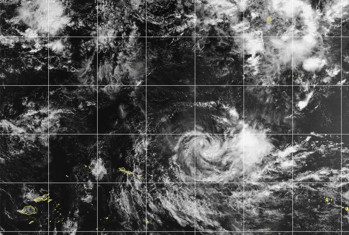
An upper level trough near Samoa produced northwesterly winds that blew across the top of Tropical Cyclone Xavier. Those winds caused strong vertical wind shear. The upper level winds blew the tops off of many thunderstorms in Tropical Cyclone Xavier. There were still some thunderstorms in bands in the eastern periphery of Xavier’s circulation. There were no thunderstorms near the center of Xavier to generate upper level divergence. Convergence of mass in the lower levels of the atmosphere caused the surface pressure to increase.
The circulation around Tropical Cyclone Xavier was small. Winds to tropical storm force extended out 90 miles (145 km) from the center of Xavier’s circulation.
Tropical Cyclone Xavier will move through an environment that will be unfavorable for intensification during the next 24 hours. Xavier will move over water where the Sea Surface Temperatures are near 28°C. It will move under the eastern part of the upper level trough that is near Samoa. The upper level trough will continue to produce northwesterly winds that will blow toward the top of Xavier’s circulation. Those winds will cause strong vertical wind shear. Tropical Cyclone Xavier will continue to weaken during the next 24 hours because of the strong vertical wind shear.
Tropical Cyclone Xavier will move around the northwestern part of a high pressure system that is south of the Cook Islands. The high pressure system will steer Xavier toward the west-southwest during the next 24 hours. On its anticipated track, the center of Tropical Cyclone Xavier will pass south of Nassau and Pukapuka.
Bands in the northern side of Tropical Cyclone Xavier will bring gusty winds and locally heavy rain to Nassau and Pukapuka. Heavy rain could cause flash floods in some locations.