
Hurricane Nolo stalled south of Hawaii early on Saturday. At 8:00 a.m. EDT on Saturday the center of Hurricane Nolo was located at latitude 16.9°N and longitude 155.3°W which put the center about 145 miles (235 km) south of South Point, Hawaii. Nolo was stationary. The maximum sustained wind speed was 105 m.p.h. (165 km/h) and there were wind gusts to 125 m.p.h. (200 km/h). The minimum surface pressure was 975 mb.
A Hurricane Watch is in effect for Hawaii County.
A Tropical Storm Warning is in effect for Hawaii County.
A Tropical Storm Watch is in effect for Maui County including Maui, Lanai, Molokai, and Kahoolawe.
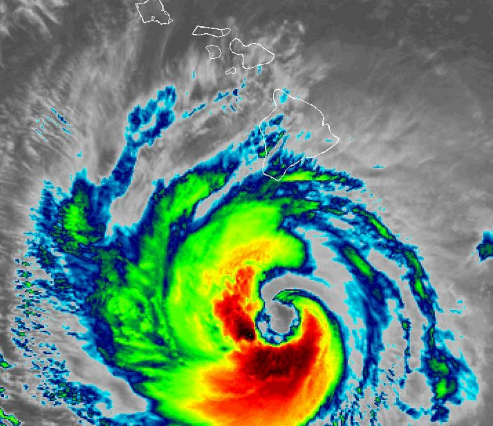
Hurricane Nolo was a Category 2 hurricane on the Saffir-Simpson Scale on Tuesday morning. A circular eye with a diameter of 23 miles (37 km) was at the center of Nolo’s circulation. They eye was surrounded by a broken ring of thunderstorms and the strongest winds were occurring in that ring of storms. Bands of showers and thunderstorms were revolving around the center of Hurricane Nolo. Storms near the center of Nolo generated upper level divergence that pumped mass away from the hurricane. The removal of mass caused the surface pressure to decrease.
Winds to hurricane force extended out 45 miles (75 km) from the center of Hurricane Nolo. Winds to tropical storm force extended out 140 miles (225 km) from the center of Nolo’s circulation.
The Hurricane Intensity Index (HII) for Hurricane Nolo is 17.8. The Hurricane Size Index (HSI) is 16.1 and the Hurricane Wind Intensity Size Index (HWISI) is 33.9.
Hurricane Nolo will move through an environment that will be somewhat favorable for intensification during the next 24 hours. Nolo will move over water where the Sea Surface Temperatures are near 28°C. It will move under the southeastern part of an upper level low that is northwest of Hawaii. The upper level low will produce southerly winds that will blow toward the top of Nolo’s circulation. Those winds will cause some vertical wind shear. The vertical wind shear will inhibit intensification, but the wind shear may not be enough to prevent intensification. Hurricane Nolo could intensify gradually during the next 24 hours. Nolo could strengthen to a major hurricane during the weekend.
A high pressure system north of Hawaii is forecast to strengthen on Saturday. When the high pressure system strengthens, it will start to steer Hurricane Nolo toward the west. On its anticipated track, the center of Hurricane Nolo will remain south of Hawaii during the weekend.
The circulation around the northern side of Hurricane Nolo will produce easterly winds in parts of the Big Island of Hawaii and on Maui. Heavy rain could fall where those winds blow up the slopes of hills and mountains. Heavy could cause flash floods in some locations.
Flood Watches are in effect for the Big Island of Hawaii, Maui, Lanai, Molokai, and Kahoolawe.