
Tag Archives: 01C

Tropical Storm Lala Brings Wind and Rain to Honolulu

Tropical Storm Lala brought wind and rain to Honolulu on Sunday.  At 2:00 p.m. EDT on Sunday the center of Tropical Storm Lala was located at latitude 20.7°N and longitude 158.8°W which put the center about 75 miles (120 km) southwest of Honolulu, Hawaii.  Lala was moving toward the northwest at 14 m.p.h. (22 km/h).  The maximum sustained wind speed was 65 m.p.h. (105 km/h) and there were wind gusts to 80 m.p.h. (130 km/h).  The minimum surface pressure was 994 mb.

A Tropical Storm Warning is in effect for Maui County including Maui, Lanai, Molokai, and Kahoolawe.  A Tropical Storm Warning is in effect for Oahu and for Kauai County including Kauai and Niihau.

Almost 60,000 customers in Hawaii are without electricity because of Tropical Storm Lala.

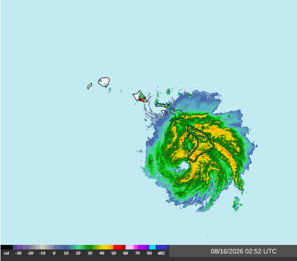
Former Hurricane Lala weakened as it moved south of the Hawaiian Islands on Sunday.  However, the circulation around Tropical Storm Lala was still very well organized.  A small circular eye was evident at the center of Lala’s circulation on radar images.  The eye was surrounded by a ring of thunderstorms and the strongest winds were occurring in that ring of storms.  Bands of showers and thunderstorms were revolving around the center of Tropical Storm Lala.  Storms near the center of Lala generated upper level divergence that pumped mass away from the hurricane.  The removal of mass in the upper levels was less than the convergence of mass in the lower levels of the atmosphere.  So, the surface pressure increased on Sunday.

The distribution of wind speeds in Tropical Storm Lala continued to be asymmetrical.  Winds to tropical storm force extended out 140 miles (225 km) in the northern side of Lala’s circulation.  Winds to tropical storm force only extended out 60 miles (95 km) in the southern side of Tropical Storm Lala.

Tropical Storm Lala will move through an environment that will be unfavorable for intensification during the next 24 hours.  Lala will move over water where the Sea Surface Temperatures are near 27°C.  It will move under the middle of an upper level ridge that is southwest of Hawaii.  The upper level winds are weak near the middle of the ridge and there will be little vertical wind shear.  However, Tropical Storm Lala will continue to move into a region of drier air that is southwest of Hawaii.  Tropical Storm Lala is likely to continue to weaken gradually during the next 24 hours because of the effects of the drier air.

Tropical Storm Lala will move around the southern part of a high pressure system that is over the Central North Pacific Ocean.  The high pressure system will steer Lala toward the west during the next 24 hours.  On its anticipated track, the center of Tropical Storm Lala will pass south of Kauai.

Bands in the northern and eastern parts of Tropical Storm Lala will continue to bring gusty winds and heavy rain to Maui, Lanai, Molokai, Kahoolawe, Oahu, Kauai, and Niihau during the next few hours.  Heavy rain is likely to cause flash floods in some locations.

Flood Watches are in effect for Maui County, Oahu, and Kauai County.
Hurricane Lala Brings Wind and Rain to Hawaii

Hurricane Lala brought wind and rain to Hawaii on Saturday.  At 11:00 p.m. EDT on Saturday the center of Hurricane Lala was located at latitude 18.7°N and longitude 156.0°W which put the center about 30 miles (50 km) southwest of South Point, Hawaii.  Lala was moving toward the northwest at 9 m.p.h. (15 km/h).  The maximum sustained wind speed was 80 m.p.h. (130 km/h) and there were wind gusts to 95 m.p.h. (150 km/h).  The minimum surface pressure was 985 mb.

A Hurricane Warning is in effect for Hawaii County.

A Tropical Storm Warning is in effect for Maui County including Maui, Lanai, Molokai, and Kahoolawe.  A Tropical Storm Warning is in effect for Oahu and for Kauai County including Kauai and Niihau.

The northeastern part of the eyewall of Hurricane Lala was over the southern end of the Big Island of Hawaii on Saturday evening.  The eye of Lala was passing just to the southwest of the Big Island.

A weather station at South Point reported a sustained wind speed of 35 m.p.h. (56 km/h) and a wind gust of 52 m.p.h. (84 km/h).

A weather station at Kailua Kona, Hawaii reported a sustained wind speed of 52 m.p.h. (85 km/h) and a wind gust of 71 m.p.h. (115 km/h).

A weather station in Kawaihae, Hawaii reported a sustained wind speed of 39 m.p.h. (63 km/h) and a wind gust of 61 m.p.h. (98 km/h).

Hurricane Lala strengthened a little more on Saturday evening.  A circular eye with a diameter of 20 miles (32 km) was at the center of Lala’s circulation.  The eye was surrounded by a ring of thunderstorms and the strongest winds were occurring in that ring of storms.  Bands of showers and thunderstorms were revolving around the center of Lala’s circulation.  Storms near the center of Lala generated upper level divergence that pumped mass away from the hurricane.  The removal of mass in the upper levels caused the surface pressure to decrease on Saturday.

The strongest winds were occurring in the northern part of Hurricane Lala.  Winds to hurricane force extended out 45 miles (75 km) in the northern side of Lala’s circulation.  Wind to tropical storm force extended out 175 miles (280 km) in the northern side of Hurricane Lala.  Winds to tropical storm force only extended out 60 miles (95 km) in the southern side of Lala’s circulation.

Hurricane Lala will move into an environment that will become unfavorable for intensification during the next 24 hours.  Lala will move over water where the Sea Surface Temperatures are near 27°C.  It will move under the middle of an upper level ridge that is southwest of Hawaii. The upper level winds are weak near the middle of the ridge and there will be little vertical wind shear.  However, Hurricane Lala will continue to move into a region of drier air that is southwest of Hawaii.  In addition, the flow in the northeastern part of Lala’s circulation will be disrupted by the volcanic mountains on the Big Islands of Hawaii.  Hurricane Lala is likely to weaken on Sunday because of the disruption to its circulation and the effects of the drier air.

Hurricane Lala is likely to continue to move toward the northwest during the next few hours as Lala’s circulation interacts with the terrain on the Big Island of Hawaii.  Lala will move around the southern part of a high pressure system that is over the Central North Pacific Ocean on Sunday.  The high pressure system will steer Lala toward the west after it moves away from the Big Island.  On its anticipated track, the center of Hurricane Lala will pass south of Maui, Oahu, and Kauai.

Hurricane Lala will continue to bring strong winds and heavy rain to the Big Island of Hawaii during the next few hours.  Hurricane Lala could drop 16 to 20 inches (400 to 500 mm) of rain on the eastern slopes where the wind blows of the slope.   Isolated locations could receive 25 inches (635 mm) of rain.  Heavy rain is likely to cause flash floods in some locations.

Hurricane Lala will also bring gusty winds and heavy rain to Maui, Lanai, Molokai, Kahoolawe, Oahu, Kauai, and Niihau even though the center of circulation will pass south of those islands.

A Flash Flood Warning is in effect for the Big Island of Hawaii.

Flood Watches are in effect for Maui County, Oahu, and Kauai County.

Lala Strengthens to a Hurricane Near Hawaii

Former Tropical Storm Lala strengthened to a hurricane on Saturday as it brought wind and rain to Hawaii.  At 3:00 p.m. EDT on Saturday the center of Hurricane Lala was located at latitude 17.9°N and longitude 155.1°W which put the center about 85 miles (135 km) south-southeast of South Point, Hawaii.  Lala was moving toward the west at 10 m.p.h. (16 km/h).  The maximum sustained wind speed was 75 m.p.h. (120 km/h) and there were wind gusts to 90 m.p.h. (145 km/h).  The minimum surface pressure was 988 mb.

A Hurricane Warning is in effect for Hawaii County.

A Tropical Storm Warning is in effect for Maui County including Maui, Lanai, Molokai, and Kahoolawe.  A Tropical Storm Warning is in effect for Oahu and for Kauai County including Kauai and Niihau.

Bands in the northern side of Hurricane Lala are already bringing gusty winds and rain to parts of Hawaii.

A weather station at Puulao on the Big Island of Hawaii reported a sustained wind speed of 46 m.p.h. (74 km/h) and a wind gust of 69 m.p.h. (111 km/h).  The weather station is at an elevation of 3366 feet (1026 m).

The weather station at the Daniel K. Inouye Airport in Honolulu reported a wind gust of 40 m.p.h. (64 km/h).

Former Tropical Storm Lala strengthened to a hurricane on Saturday.  The inner end of a rainband wrapped around the center of Lala’s circulation.  A circular eye was evident on satellite and radar images at the center of Hurricane Lala.  The eye was surrounded by a broken ring of thunderstorms and the strongest winds were occurring in that broken rings of storms.  Bands of showers and thunderstorms were revolving around the center of Lala’s circulation.  Storms near the center of Lala generated upper level divergence that pumped mass away from the hurricane.  The removal of mass in the upper levels caused the surface pressure to decrease on Saturday.

The distribution of wind speeds in Hurricane Lala was still asymmetrical.  Winds to tropical storm force extended out 205 miles (335 km) in the northern half of Lala’s circulation.  Winds to tropical storm force extended out only 45 miles in the southern half of Hurricane Lala.

Hurricane Lala will move through an environment favorable for intensification during the next 24 hours.  Lala will move over water where the Sea Surface Temperatures are near 27°C. It will move under the southern part of an upper level trough that is northeast of Hawaii.  The upper level ridge will produce southwesterly winds that will blow toward the top of Lala’s circulation.  Those winds will cause some vertical wind shear.  The vertical wind shear will inhibit intensification, but the wind shear will not be enough to prevent intensification.  Lala will continue to move into a region of drier air as it comes close to the Big Island of Hawaii.  Hurricane Lala is likely to intensify to a hurricane during the next 24 hours even with the effects of the wind shear and drier air.

Hurricane Lala will move around the southern side of a high pressure system over the Central Pacific Ocean.  The high pressure system will steer Lala toward the west-northwest during the next 24 hours.  As the circulation around Tropical Storm Lala interacts with the terrain on the Big Island of Hawaii, Lala could be pulled northwest for a few hours.  On its anticipated track, the center of Hurricane Lala will come very close to the Big Island of Hawaii in a few hours.

Hurricane Lala could be a hurricane when the center of circulation comes near the Big Island of Hawaii.   Lala will bring strong winds and heavy rain to the Big Island of Hawaii.  Hurricane Lala could drop 16 to 20 inches (400 to 500 mm) of rain on the eastern slopes where the wind blows of the slope.   Isolated locations could receive 25 inches (635 mm) of rain.  Heavy rain is likely to cause flash floods in some locations.

Hurricane Lala will also bring gusty winds and heavy rain to Maui, Lanai, Molokai, Kahoolawe, Oahu, Kauai, and Niihau.

Flood Watches are in effect for Hawaii County, Maui County, Oahu, and Kauai County.

Tropical Storm Lala Moves Closer to Hawaii

Tropical Storm Lala moved steadily closer to Hawaii on Friday.  At 5:00 p.m. EDT on Friday the center of Tropical Storm Lala was located at latitude 17.2°N and longitude 150.9°W which put the center about 340 miles (545 km) east-southeast of South Point, Hawaii.  Lala was moving toward the west-northwest at 14 m.p.h. (22 km/h).  The maximum sustained wind speed was 60 m.p.h. (95 km/h) and there were wind gusts to 75 m.p.h. (120 km/h).  The minimum surface pressure was 997 mb.

A Hurricane Warning is in effect for Hawaii County.

A Tropical Storm Warning is in effect for Maui County including Maui, Lanai, Molokai, and Kahoolawe.

A Tropical Storm Watch is in effect for Oahu and for Kauai County including Kauai and Niihau.

Tropical Storm Lala was exhibiting signs of greater organization on Friday afternoon.  The inner end of a rainband was wrapping around the northern side of the center of Lala’s circulation.  An eye could be forming at the center of Tropical Storm Lala.  Bands of showers and thunderstorms were revolving around the center of Lala’s circulation.  Storms near the center of Lala generated upper level divergence that pumped mass away from the tropical storm.  The removal of mass in the upper levels was nearly equal to the convergence of mass in the lower levels of the atmosphere.  So, the surface pressure remained nearly steady on Friday.

The distribution of wind speeds in Tropical Storm Lala continued to be asymmetrical on Friday. Winds to tropical storm force extended out 195 miles (315 km) in the northern half of Lala’s circulation.  The winds in the southern half of Tropical Storm Lala were blowing at less than tropical storm force.

Tropical Storm Lala will move through an environment favorable for intensification during the next 24 hours.  Lala will move over water where the Sea Surface Temperatures are near 27°C. It will move under the eastern part of an upper level ridge that is east of Hawaii.  The upper level ridge will produce northeasterly winds that will blow toward the top of Lala’s circulation.  Those winds will cause some vertical wind shear.  The vertical wind shear will inhibit intensification, but the wind shear will not be enough to prevent intensification.  Lala will move into a region of drier air as it continues to approach Hawaii.  Tropical Storm Lala is likely to intensify during the next 24 hours even with the effects of the wind shear and drier air.  Lala could strengthen to a hurricane on Saturday.

Tropical Storm Lala will move around the southern side of a high pressure system over the Central Pacific Ocean.   The high pressure system will steer Lala toward the west-northwest during the next 24 hours. On its anticipated track, Tropical Storm Lala will approach the Big Island of Hawaii on in 24 hours.

Tropical Storm Lala could be a hurricane when it approaches the Big Island of Hawaii.  Lala will bring strong winds and heavy rain to the Big Island of Hawaii.  Lala could drop 16 to 20 inches (400 to 500 mm) of rain on the eastern slopes where the wind blows of the slope.  Isolated locations could receive 25 inches (635 mm) of rain.  Heavy rain is likely to cause flash floods in some locations.

Flood Watches are in effect for Hawaii County, Maui County, Oahu, and Kauai County.

Tropical Storm Lala Strengthens, Hurricane Warning for Hawaii

Tropical Storm Lala strengthened on Thursday evening.  A Hurricane Warning was issued for the Big Island of Hawaii.  At 11:00 p.m. EDT on Thursday the center of Tropical Storm Lala was located at latitude 16.2°N and longitude 147.5°W which put the center about 555 miles (890 km) east-southeast of Hilo, Hawaii.  Lala was moving toward the west-northwest at 12 m.p.h. (19 km/h).  The maximum sustained wind speed was 60 m.p.h. (95 km/h) and there were wind gusts to 75 m.p.h. (120 km/h).  The minimum surface pressure was 997 mb.

A Hurricane Warning is in effect for Hawaii County.

A Tropical Storm Watch is in effect for Maui County including Maui, Lanai, Molokai, and Kahoolawe.

Reconnaissance aircraft found that Tropical Storm Lala had strengthened on Thursday evening.  Even though Lala was stronger, the distribution of thunderstorms was asymmetrical.  Thunderstorms were occurring mainly in bands north and east of the center of Tropical Storm Lala.  Bands in the southern and western parts of Lala’s circulation consisted primarily of showers and lower clouds.  Storms near the center of Lala generated upper level divergence that pumped mass away from the tropical storm. The removal of mass caused the surface pressure to decrease.

The strongest winds were occurring in the northern side of Tropical Storm Lala.  Winds to tropical storm force extended out 275 miles (445 km) in the northern half of Lala’s circulation.   The winds in the southern half of Tropical Storm Lala were blowing at less than tropical storm force.

Tropical Storm Lala will move through an environment favorable for intensification during the next 24 hours.  Lala will move over water where the Sea Surface Temperatures are near 27°C.  It will move under the eastern part of an upper level ridge that is east of Hawaii.  The upper level ridge will produce northeasterly winds that will blow toward the top of Lala’s circulation.  Those winds will cause some vertical wind shear.  The vertical wind shear will inhibit intensification, but the wind shear will not be enough to prevent intensification.  Lala will move into a region of drier air as it approaches Hawaii.  Tropical Storm Lala is likely to intensify during the next 24 hours even with the effects of the wind shear and drier air.  Lala could strengthen to a hurricane during the next 48 hours.

Tropical Storm Lala will move around the southern side of a high pressure system over the Central Pacific Ocean.  The high pressure system will steer Lala toward the west-northwest during the next 24 hours.  On its anticipated track, Tropical Storm Lala will move toward Hawaii. The center of Lala’s circulation could reach the Big Island of Hawaii on within 48 hours.

Tropical Storm Lala could be a hurricane when it approaches the Big Island of Hawaii.  Lala will bring strong winds and heavy rain to the Big Island of Hawaii.  Lala could drop 10 to 15 inches (2554 to 380 mm) of rain on the eastern slopes where the wind blows of the slope.  Heavy rain is likely to cause flash floods in some locations.

Flood Watches are in effect for the Big Island of Hawaii and for Maui.

Tropical Storm Lala Forms, Hurricane Watch for Hawaii

Tropical Storm Lala formed over the Central Pacific Ocean east-southeast of Hawaii on Thursday morning.  A Hurricane Watch was issued for the Big Island of Hawaii.  At 2:00 p.m. EDT on Thursday the center of Tropical Storm Lala was located at latitude 15.4°N and longitude 145.8°W which put the center about 680 miles (1095 km) east-southeast of Hilo, Hawaii.  Lala was moving toward the west-northwest at 10 m.p.h. (16 km/h).  The maximum sustained wind speed was 40 m.p.h. (65 km/h) and there were wind gusts to 50 m.p.h. (80 km/h).  The minimum surface pressure was 1001 mb.

A Hurricane Watch is in effect for Hawaii County.

More thunderstorms formed near the center of a low pressure system formerly called Potential Tropical Cyclone One-C on Thursday morning and the U.S. Central Pacific Hurricane Center designated the system as Tropical Storm Lala.

The circulation around Tropical Storm Lala exhibited more organization on Thursday.  New thunderstorms were developing near the center of Lala’s circulation.  Other thunderstorms were occurring in bands in the southern and eastern parts of Tropical Storm Lala.  Storms near the center of Lala generated upper level divergence that pumped mass away from the tropical storm.  The removal of mass caused the surface pressure to decrease.

The strongest winds were occurring in the eastern half of Tropical Storm Lala.  Winds to tropical storm force extended out 140 miles (220 km) in the northeastern quadrant of Lala’s circulation.  Winds to tropical storm force extended out 60 miles (95 km) in the southeastern quadrant of Tropical Storm Lala.  The winds in the western half of Lala’s circulation were blowing at less than tropical storm force.

Tropical Storm Lala will move through an environment favorable for intensification during the next 24 hours.  Lala will move over water where the Sea Surface Temperatures are near 27°C.  It will move under the eastern part of an upper level ridge that is east of Hawaii.  The upper level ridge will produce northeasterly winds that will blow toward the top of Lala’s circulation.  Those winds will cause some vertical wind shear.  The vertical wind shear will inhibit intensification, but the wind shear will not be enough to prevent intensification.  Tropical Storm Lala will intensify during the next 24 hours.

Tropical Storm Lala will move around the southern side of a high pressure system over the Central Pacific Ocean.  The high pressure system will steer Lala toward the west-northwest during the next 24 hours.  On its anticipated track, Tropical Storm Lala will move toward Hawaii.  Lala could reach the Big Island of Hawaii on Saturday.

Elsewhere, Tropical Storm Hernan strengthened a little as it moved far to the west of Baja California.  At 11:00 a.m. EDT on Thursday the center of Tropical Storm Hernan was located at latitude 18.0°N and longitude 131.9°W which put the center about 1460 miles (2350 km) west of the the southern tip of Baja California.  Hernan was moving toward the west-southwest at 3 m.p.h. (5 km/h).  The maximum sustained wind speed was 45 m.p.h. (75 km/h) and there were wind gusts to 60 m.p.h. (95 km/h).  The minimum surface pressure was 1004 mb.

Tropical Storm Hernan Forms West of Baja California

Tropical Storm Hernan formed over the Eastern North Pacific Ocean west of Baja California on Wednesday night.  At 5:00 a.m. EDT on Thursday the center of Tropical Storm Hernan was located at latitude 18.1°N and longitude 131.9°W which put the center about 1460 miles (2350 km) west of the the southern tip of Baja California.  Hernan was moving toward the west at 2 m.p.h. (3 km/h).  The maximum sustained wind speed was 40 m.p.h. (65 km/h) and there were wind gusts to 50 m.p.h. (80 km/h).  The minimum surface pressure was 1006 mb.

A low pressure system over the Eastern North Pacific Ocean strengthened on Wednesday night and the U.S. National Hurricane Center designated the system as Tropical Storm Hernan.

The distribution of thunderstorms in Tropical Storm Hernan was asymmetrical.  An upper level trough near the West Coast of the U.S. was producing westerly winds that were blowing toward the top of Hernan’s circulation.  Those winds were causing moderate vertical wind shear.  The moderate vertical wind shear was causing the asymmetrical distribution of thunderstorms in Tropical Storm Hernan.

Thunderstorms were occurring in bands in the eastern side of Tropical Storm Hernan.  Bands in the western side of Hernan’s circulation consisted primarily of showers and lower clouds.  Storms near the center of Hernan generated upper level divergence that pumped mass away to the east of the tropical storm.  The removal of mass caused the surface pressure to decrease.

Even though the thunderstorms were in the eastern side of Tropical Storm Hernan, the strongest winds were occurring in the western side of Hernan.  Winds to tropical storm force extended out 40 miles (65 km) in the western side of Hernan’s circulation.  The winds in the eastern side of Tropical Storm Hernan were blowing at less than tropical storm force.

Tropical Storm Hernan will move through an environment that will be unfavorable for intensification during the next 24 hours.  Hernan will move over water where the Sea Surface Temperatures are near 26°C.  However, the upper level trough near the West Coast of the U.S. will continue to cause moderate vertical wind shear.  Tropical Storm Hernan is unlikely to intensify during the next 24 hours because of the vertical wind shear.

Tropical Storm Hernan will move around the southern part of a high pressure system over the Eastern North Pacific Ocean.  The high pressure system will steer Hernan toward the southwest during the next 24 hours.  On its anticipated track, Tropical Storm Hernan will remain far to the west of Baja California.

Elsewhere, Potential Tropical Cyclone One-C moved closer to Hawaii.  At 5:00 a.m. EDT on Thursday the center of Potential Tropical Cyclone One-C was located at latitude 14.8°N and longitude 144.5°W which put the center about 775 miles (1250 km) east-southeast of Hilo,Hawaii.   It was moving toward the west at 10 m.p.h. (16 km/h).   The maximum sustained wind speed was 40 m.p.h. (65 km/h) and there were wind gusts to 50 m.p.h. (80 km/h).   The minimum surface pressure was 1002 mb.

Gil Strengthens to a Hurricane

Former Tropical Storm Gil strengthened to a hurricane over the Eastern North Pacific Ocean southwest of Baja California on Friday.  At 11:00 p.m. EDT on Friday the center of Hurricane Gil was located at latitude 16.5°N and longitude 125.1°W which put the center about 1080 miles (1740 km) west-southwest of the southern tip of Baja California.  Gil was moving toward the west-northwest at 20 m.p.h. (32 km/h).  The maximum sustained wind speed was 75 m.p.h. (120 km/h) and there were wind gusts to 90 m.p.h. (145 km/h).  The minimum surface pressure was 991 mb.

Former Tropical Storm Gil strengthened to a hurricane on Friday.  The inner end of a rainband wrapped around the western and southern sides of the center of Gil’s circulation.  Bands of showers and thunderstorms were revolving around the center of Hurricane Gil.  Storms near the center of Gil generated upper level divergence that pumped mass away from the hurricane.  The removal of mass caused the surface pressure to decrease.

The strongest winds were occurring in the northeastern part of Hurricane Gil.  Winds to hurricane force extended out 25 miles (40 km) in the northeastern quadrant of Gil’s circulation.  Winds to tropical storm force extended out 125 miles (200 km) from the center of Hurricane Gil.

Hurricane Gil will move through an environment somewhat favorable for intensification during the next 24 hours.  Gil will move over water where the Sea Surface Temperatures are near 27°C.  It will move through a region where there will be little vertical wind shear.  However, Gil will move into a region where there is very dry air.  The dry air will inhibit intensification.  Hurricane Gil could intensify during the next 24 hours if the dry air does not penetrate to the core of Gil’s circulation.

Hurricane Gil will move around the southern side of a high pressure system over the Eastern North Pacific Ocean.  The high pressure system will steer Gil toward the west-northwest during the next 24 hours.  On its anticipated track, Hurricane Gil will continue to move farther away from Baja California.

Elsewhere, former Tropical Storm Iona weakened to a tropical depression as it approached the International Date Line.  At 11:00 p.m. EDT on Friday the center of Tropical Depression Iona was located at latitude 15.8°N and longitude 179.5°W which put the center about 1465 miles (2355 km) west of Honolulu, Hawaii.  Iona was moving toward the west-northwest at 17 m.p.h. (28 km/h).  The maximum sustained wind speed was 35 m.p.h. (55 km/h) and there were wind gusts to 45 m.p.h. (75 km/h).  The minimum surface pressure was 1008 mb.

Tropical Storm Gil Forms South of Baja California

Tropical Storm Gil formed over the Eastern North Pacific Ocean south of Baja California on Wednesday night.  At 5:00 a.m. EDT on Thursday the center of Tropical Storm Gil was located at latitude 12.7°N and longitude 115.1°W which put the center about 785 miles (1260 km) south-southwest of the southern tip of Baja California.  Gil was moving toward the west at 15 m.p.h. (24 km/h).  The maximum sustained wind speed was 45 m.p.h. (75 km/h) and there were wind gusts to 60 m.p.h. (95 km/h).  The minimum surface pressure was 1004 mb.

A low pressure system over the Eastern North Pacific Ocean south of Baja California strengthened on Wednesday night and the U.S. National Hurricane Center designated the system as Tropical Storm Gil.

The circulation around Tropical Storm Gil was organizing quickly on Thursday morning.  Numerous thunderstorms formed near the center of Gil’s circulation.  Thunderstorms also developed in bands revolving around the center of Tropical Storm Gil.  Storms near the center of Gil generated upper level divergence that pumped mass away from the tropical storm.  The removal of mass caused the surface pressure to decrease.

The distribution of wind speed in Tropical Storm Gil was asymmetrical.  Winds to tropical storm force extended out 160 miles (260 km) in the eastern side of Gil’s circulation.  Winds to tropical storm force extended out 60 miles (95 km) in the western side of Tropical Storm Gil.

Tropical Storm Gil will move through an environment very favorable for intensification during the next 24 hours.  Gil will move over water where the Sea Surface Temperatures are near 28°C.   It will move under the southern side of an upper level ridge over the Eastern North Pacific Ocean.  The upper level ridge will produce easterly winds that will blow toward the top of Gil’s circulation.  However, the winds in the lower atmosphere will also blow from the east.  So, there will be little vertical wind shear.  Tropical Storm Gil will intensify during the next 24 hours.  Gil could intensify rapidly,  Tropical Storm Gil could strengthen to a hurricane by Friday.

Tropical Storm Gil will move around the southern side of a high pressure system over the Eastern North Pacific Ocean.  The high pressure system will steer Gil toward the west-northwest during the next 24 hours.  On its anticipated track, Tropical Storm Gil will move away from Baja California.

Elsewhere, Tropical Storm Iona moved quickly away from Hawaii.  At 5:00 a.m. EDT on Thursday the center of Tropical Storm Iona was located at latitude 12.3°N and longitude 166.9°W which put the center about 860 miles (1385 km) southwest of Honolulu, Hawaii.  Iona was moving toward the west at 23 m.p.h. (37 km/h).  The maximum sustained wind speed was 50 m.p.h. (80 km/h) and there were wind gusts to 65 m.p.h. (105 km/h).  The minimum surface pressure was 1001 mb.

Iona Rapidly Weakens to a Tropical Storm

Former Hurricane Iona rapidly weakened to a tropical storm over the Central Pacific Ocean southwest of Hawaii on Wednesday.  At 5:00 p.m. EDT on Wednesday the center of Tropical Storm Iona was located at latitude 11.7°N and longitude 162.6°W which put the center about 730 miles (1180 km) south-southwest of Honolulu, Hawaii.  Iona was moving toward the west at 22 m.p.h. (35 km/h).  The maximum sustained wind speed was 65 m.p.h. (105 km/h) and there were wind gusts to 80 m.p.h. (130 km/h).  The minimum surface pressure was 994 mb.

Former Hurricane Iona rapidly weakened to a tropical storm southwest of Hawaii on Wednesday.  Iona moved into a region of drier air.  The drier air caused many of the thunderstorms in Iona’s circulation to dissipate.  A few thunderstorms were still occurring in bands in the southern and eastern periphery of Tropical Storm Iona.  An upper level trough southwest of Hawaii was producing southwesterly winds that were blowing toward the top of Iona’s circulation.  Those winds were causing moderate vertical wind shear.  The vertical wind shear was also contributing to the weakening of Tropical Storm Iona.

The circulation around Tropical Storm Iona was small.  Winds to tropical storm force extended out 80 miles (130 km) from the center of Iona’s circulation.

Tropical Storm Iona will move through an environment that will be mostly unfavorable for intensification during the next 24 hours.  Iona will move over water where the Sea Surface Temperatures are near 27°C.  It will move under the southeastern part of the upper level trough southwest of Hawaii.  The upper level trough will continue to produce southwesterly winds that will blow toward the top of Iona’s circulation.  Those winds will continue to cause moderate vertical wind shear.  In addition, Iona will also continue to move through the region of drier air that is located southwest of Hawaii.  The combination of moderate vertical wind shear and drier air will cause Tropical Storm Iona to start to continue to weaken during the next 24 hours.

Tropical Storm Iona will move around the southern side of a high pressure system over the Central Pacific Ocean.  The high pressure system will steer Iona toward the west during the next 24 hours.  On its anticipated track, Hurricane Iona will move farther away from of Hawaii on Thursday.

Elsewhere over the Central Pacific Ocean, the upper level trough southwest of Hawaii caused former Tropical Storm Keli to weaken to a tropical depression.  At 5:00 p.m. EDT on Wednesday the center of Tropical Depression Keli was located at latitude 13.9°N and longitude 156.6°W which put the center about 520 miles (835 km) south of Honolulu, Hawaii.  Keli was moving toward the west at 17 m.p.h. (28 km/h).  The maximum sustained wind speed was 35 m.p.h. (55 km/h) and there were wind gusts to 45 m.p.h. (75 km/h).  The minimum surface pressure was 1006 mb.