Tag Archives: Fiji

Tropical Cyclone Tiffany Makes Landfall near Port Roper

Tropical Cyclone Tiffany made landfall near Port Roper, Australia on Tuesday night. At 10:00 p.m. EST on Tuesday the center of Tropical Cyclone Tiffany was located at latitude 14.9°S and longitude 134.7°E which put it about 45 miles (75 km) west of Port Roper, Australia. Tiffany was moving toward the west at 16 m.p.h. (26 km/h). The maximum sustained wind speed was 50 m.p.h. (80 km/h) and there were wind gusts to 65 m.p.h. (105 km/h). The minimum surface pressure was 991 mb.

The center of Tropical Cyclone Tiffany made landfall near Port Roper on the west coast of the Gulf of Carpentaria on Tuesday night. Tiffany was the equivalent of a strong tropical storm at the time of landfall. Winds to tropical storm force extended out 65 miles (105 km) from the center of circulation. Bands of showers and thunderstorms were dropping heavy rain over the region west of Port Roper. A Flood Watch was in effect for many of the rivers in the area.

Tropical Cyclone Tiffany will move around the northern side of a high pressure system over Australia. The high pressure system will steer Tiffany toward the west during the next 24 hours. On its anticipated track Tropical Cyclone Tiffany will move across the northern part of the Northern Territory. The center of Tiffany will pass near Ngukurr, Mataranka, Barunga and Katherine. Tropical Cyclone Tiffany will weaken gradually as it moves farther inland, but it will continue to drop heavy rain over the northern part of the Northern Territory. Locally heavy rain is likely to cause flash floods in some location.

Elsewhere over the South Pacific Ocean, Tropical Cyclone Cody was moving farther southwest of Fiji. At 10:00 p.m. EST on Tuesday the center of Tropical Cyclone Cody was located at latitude 23.1°S and longitude 174.1°E which put it about 435 miles (705 km) southwest of Suva, Fiji. Cody was moving toward the south at 12 m.p.h. (19 km/h). The maximum sustained wind speed was 60 m.p.h. (95 km/h) and there were wind gusts to 75 m.p.h. (120 km/h). The minimum surface pressure was 985 mb.

Tropical Cyclone Tiffany Strengthens over Gulf of Carpentaria

Tropical Cyclone Tiffany strengthened over the Gulf of Carpentaria on Tuesday morning. At 10:00 a.m. EST on Tuesday the center of Tropical Cyclone Tiffany was located at latitude 15.2°S and longitude 137.4°E which put it about 100 miles (160 km) southeast of Groote Eylandt, Australia. Tiffany was moving toward the west at 16 m.p.h. (26 km/h). The maximum sustained wind speed was 50 m.p.h. (80 km/h) and there were wind gusts to 65 m.p.h. (105 km/h). The minimum surface pressure was 991 mb.

A Warning was in effect for the portion of the coast of the Northern Territory from Nhulunbuy to the border with Queensland. The Warning included Groote Eylandt, Port Roper and Port McArthur.

Tropical Cyclone Tiffany exhibited greater organization as it strengthened on Tuesday morning. The inner end of a rainband wrapped around the northern side of the center of circulation and a partial eyewall appeared to be developing. Bands of showers and thunderstorms were revolving around the center of Tiffany’s circulation. Storms near the center generated upper level divergence that pumped mass away to the west of the tropical cyclone. Winds to tropical storm force extended out 60 miles (95 km) from the center of Tiffany.

Tropical Cyclone Tiffany will move through an environment favorable for intensification during the next 12 hours. Tiffany will move over water where the Sea Surface Temperatures are near 31˚C. It will move under the northern part of an upper level ridge over eastern Australia. The ridge will produce easterly winds that will blow toward the top of Tiffany’s circulation. Those winds will cause some vertical wind shear and the wind shear will inhibit intensification. However, Tropical Cyclone Tiffany will intensify over the warm water in the Gulf of Carpentaria during the next 12 hours.

Tropical Cyclone Tiffany will move around the northern side of a high pressure system over Australia during the next 24 hours. The high pressure system will steer Tiffany toward west. On its anticipated track the center of Tropical Cyclone Tiffany will pass south of Groote Eylandt during the next few hours. Tiffany will make landfall on the coast of the Northern Territory near Port Roper in about 12 hours. Tropical Cyclone Tiffany will bring gusty winds and locally heavy rain to the eastern part of the Northern Territory. Heavy rain could cause flash floods in some locations. Flood Watches have been issued for rivers in the eastern part of the Northern Territory.

Elsewhere over the South Pacific Ocean, Tropical Cyclone Cody was continued to churn southwest of Fiji. At 10:00 a.m. EST on Tuesday the center of Tropical Cyclone Cody was located at latitude 21.5°S and longitude 173.5°E which put it about 390 miles (625 km) southwest of Suva, Fiji. Cody was moving toward the south-southeast at 4 m.p.h. (6 km/h). The maximum sustained wind speed was 50 m.p.h. (80 km/h) and there were wind gusts to 65 m.p.h. (105 km/h). The minimum surface pressure was 991 mb.

Tropical Cyclone Tiffany Crosses Cape York Peninsula

Tropical Cyclone Tiffany crossed the Cape York Peninsula on Monday. At 4:00 p.m. EST on Monday the center of Tropical Cyclone Tiffany was located at latitude 14.8°S and longitude 140.9°E which put it about 55 miles (90 km) west of Pormpuraaw, Australia. Tiffany was moving toward the west at 16 m.p.h. (26 km/h). The maximum sustained wind speed was 40 m.p.h. (65 km/h) and there were wind gusts to 50 m.p.h. (80 km/h). The minimum surface pressure was 997 mb.

A Warning was in effect for Groote Eylandt. A Watch was in effect for the portion of the coast of the Northern Territory from Nhulunbuy to the border with Queensland. The Watch included Numbalwar, Port Roper and Port McArthur.

The center of Tropical Cyclone Tiffany emerged over the eastern Gulf of Carpentaria near Pormpuraaw on Monday after it moved westward across the Cape York Peninsula. New thunderstorms were forming in bands in the western and northern parts of Tiffany’s circulation. Bands in the eastern and southern parts of the circulation were still over land and those bands contained fewer thunderstorms. The strongest winds were occurring in the bands over the Gulf of Carpentaria. Winds to tropical storm force extended out 30 miles (50 km) from the center of Tropical Cyclone Tiffany.

Tropical Cyclone Tiffany will move through an environment favorable for intensification during the next 24 hours. Tiffany will move over water where the Sea Surface Temperatures are near 31˚C. It will move under the northern part of an upper level ridge over eastern Australia. The ridge will produce easterly winds that will blow toward the top of Tiffany’s circulation. Those winds will cause some vertical wind shear and the wind shear will inhibit intensification. However, Tropical Cyclone Tiffany will intensify over the warm water in the Gulf of Carpentaria. Tiffany could intensify rapidly once more of the circulation moves over water and it could strengthen to the equivalent of a hurricane/typhoon.

Tropical Cyclone Tiffany will move around the northern side of a high pressure system over Australia during the next 36 hours. The high pressure system will steer Tiffany toward west. On its anticipated track Tropical Cyclone Tiffany could approach Groote Eylandt in 24 hours. Tiffany could be the equivalent of a hurricane/typhoon when it approaches Groote Eylandt.

Elsewhere over the South Pacific Ocean, Tropical Cyclone Cody was continued to meander southwest of Fiji. At 4:00 p.m. EST on Monday the center of Tropical Cyclone Cody was located at latitude 20.9°S and longitude 174.1°E which put it about 330 miles (535 km) southwest of Suva, Fiji. Cody was moving toward the west at 13 m.p.h. (20 km/h). The maximum sustained wind speed was 45 m.p.h. (75 km/h) and there were wind gusts to 60 m.p.h. (95 km/h). The minimum surface pressure was 994 mb.

Tropical Cyclone Tiffany Brings Wind and Rain to Northern Queensland

Tropical Cyclone Tiffany brought wind and rain to northern Queensland on Sunday night. At 10:00 p.m. EST on Sunday the center of Tropical Cyclone Tiffany was located at latitude 14.3°S and longitude 144.0°E which put it about 70 miles (110 km) east-southeast of Coen, Australia. Tiffany was moving toward the west-southwest at 8 m.p.h. (13 km/h). The maximum sustained wind speed was 65 m.p.h. (105 km/h) and there were wind gusts to 80 m.p.h. (130 km/h). The minimum surface pressure was 987 mb.

Warnings were in effect for the east coast of the Cape York Peninsula from Lockhart River to Cape Flattery and for the west coast of the Cape York Peninsula from Weipa to Kowanyama. A Watch was issued for the west coast of the Gulf of Carpentaria from Nhulunbuy to the border between the Northern Territory and Queensland. The Watch included Groote Eylandt.

The center of Tropical Cyclone Tiffany made landfall on the east coast of Queensland east-southeast of Coen on Sunday night. Tiffany was the equivalent of a strong tropical storm at the time of landfall. Bands of showers and thunderstorms in the western half of Tiffany’s circulation brought gusty winds to northern Queensland. Winds to tropical storm force extended out 70 miles (110 km) from the center of circulation. Tropical Cyclone Tiffany was also dropping locally heavy rain over parts of northern Queensland. A Minor Flood Warning was issued for the Daintree River and a Flood Warning was issued for the Mossman River.

Tropical Cyclone Tiffany will move around the northern side of a high pressure system over Australia. The high pressure system will steer Tiffany toward the west during the next several days. On its anticipated track Tropical Cyclone Tiffany will move across the Cape York Peninsula during the next 18 hours. Tiffany will weaken while it moves over land. In 18 hours the center of Tropical Cyclone Tiffany will move over the Gulf of Carpentaria. The Sea Surface Temperatures are near 31˚C in the Gulf of Carpentaria. So, Tiffany could strengthen when it moves back over water. An upper level ridge over Australia will produce easterly winds that will blow toward the top of Tiffany’s circulation. Those winds will cause vertical wind shear and they will inhibit intensification, but Tropical Cyclone Tiffany is forecast to intensify after it moves over the Gulf of Carpentaria.

Elsewhere over the South Pacific Ocean, Tropical Cyclone Cody was located southwest of Fiji. At 10:00 p.m. EST on Sunday the center of Tropical Cyclone 05P was located at latitude 20.1°S and longitude 176.1°E which put it about 150 miles (240 km) west-southwest of Tavuki, Fiji. Cody was moving toward the west-southwest at 5 m.p.h. (8 km/h). The maximum sustained wind speed was 45 m.p.h. (75 km/h) and there were wind gusts to 60 m.p.h. (95 km/h). The minimum surface pressure was 994 mb.

Tropical Cyclone Tiffany Strengthens East of Cape York Peninsula

Tropical Cyclone Tiffany strengthened east of the Cape York Peninsula on Sunday morning. At 7:00 a.m. EST on Sunday the center of Tropical Cyclone Tiffany was located at latitude 13.9°S and longitude 145.9°E which put it about 120 miles (190 km) north-northeast of Cooktown, Australia. Tropical Cyclone was moving toward the west at 9 m.p.h. (14 km/h). The maximum sustained wind speed was 60 m.p.h. (95 km/h) and there were wind gusts to 75 m.p.h. (120 km/h). The minimum surface pressure was 990 mb.

A Warning was in effect for the portion of the east coast of the Cape York Peninsula from Cape Grenville to Cape Tribulation. A Watch was in effect for the west coast of the Cape York Peninsula from Gilbert River Mouth to Mapoon.

A former Tropical Low east of the Cape York Peninsula strengthened quickly on Sunday morning and the Australian Bureau of Meteorology designated the system as Tropical Cyclone Tiffany. More Thunderstorms developed near the center of Tiffany’s circulation. More thunderstorms also formed in bands revolving around the center of Tropical Cyclone Tiffany. Storms near the center of circulation generated upper level divergence that pumped mass away from the tropical cyclone. Winds to tropical storm force extended out 70 miles (110 km) from the center of Tiffany.

Tropical Cyclone Tiffany will move through an environment favorable for intensification during the next 12 hours. Tiffany will move over water where the Sea Surface Temperatures are near 30˚C. It will move under the northwestern part of an upper level ridge centered east of Australia. The ridge will produce easterly winds that will blow toward the top of the Tropical Low’s circulation. Those winds will cause some vertical wind shear, but the shear will not be strong enough to prevent intensification. The center of Tropical Cyclone Tiffany will pass near Cape Melville in 12 hours. If some of the circulation on the southern side of Tiffany passes over land, that could inhibit intensification.

Tropical Cyclone Tiffany will move north of a high pressure system over Australia. The high pressure system will steer Tiffany toward the west during the next 36 hours. On its anticipated track the center of Tropical Cyclone Tiffany will pass just north of Cape Melville in 12 hours. Tiffany will make landfall on the east coast of the Cape York Peninsula east of Coen within 24 hours. Tropical Cyclone Tiffany will bring gusty winds and locally heavy rain to northern Queensland. Heavy rain is likely to cause flash floods in some locations.
Elsewhere over the South Pacific Ocean, Tropical Cyclone 05P was spinning between Fiji and Vanuatu. At 4:00 a.m. EST on Sunday the center of Tropical Cyclone 05P was located at latitude 18.9°S and longitude 176.3°E which put it about 150 miles (240 km) west of Tavuki, Fiji. Tropical Cyclone 05P was moving toward the east-southeast at 13 m.p.h. (20 km/h). The maximum sustained wind speed was 35 m.p.h. (55 km/h) and there were wind gusts to 45 m.p.h. (75 km/h). The minimum surface pressure was 1000 mb.

Two Tropical Lows Form over South Pacific

Two tropical lows formed over the South Pacific Ocean on Saturday morning. The first Tropical Low formed over the Coral Sea east of the Cape York Peninsula. At 7:00 a.m. EST on Saturday the center of that Tropical Low was located at latitude 13.0°S and longitude 147.8°E which put it about 240 miles (350 km) northeast of Cooktown, Australia. The Tropical Low was nearly stationary. The maximum sustained wind speed was 30 m.p.h. (50 km/h) and there were wind gusts to 40 m.p.h. (65 km/h). The minimum surface pressure was 1004 mb.

A well defined low level center of circulation formed in a small low pressure system over the Coral Sea on Saturday morning and the Australian Bureau of Meteorology designated the system as a Tropical Low. A Watch was issued for the portion of the east coast of the Cape York Peninsula from Cape Grenville to Cape Tribulation. The distribution of thunderstorms around the Tropical Low was asymmetrical. The distribution of thunderstorms around the Tropical Low was asymmetrical. The strongest thunderstorms were occurring in bands in the northwestern quadrant of the circulation. Bands in other parts of the circulation consisted primarily of showers and lower clouds. Storms near the center began to generate upper level divergence that pumped mass away from the Tropical Low.

The Tropical Low will move through an environment somewhat favorable for intensification during the next 24 hours. The Tropical Low will move over water where the Sea Surface Temperatures are near 30˚C. It will move under the northwestern part of an upper level ridge centered east of Australia. The ridge will produce easterly winds that will blow toward the top of the Tropical Low’s circulation. Those winds will cause some vertical wind shear and the shear will inhibit intensification. The Tropical Low could intensify gradually during the next 24 hours.

The Tropical Low will move north of a high pressure system centered east of Australia. The high pressure system will steer the Tropical Low toward the west during the next 24 hours. On its anticipate track the Tropical Low could approach the eastern Cape York Peninsula between Lockhart River and Cooktown in 36 hours. It could be a named tropical cyclone when it approaches the coast.

The second Tropical Low developed over the South Pacific Ocean west of Fiji. At 10:00 a.m. EST on Saturday the center of the second Tropical Low was located at latitude 18.6°S and longitude 173.3°E which put it about 320 miles (515 km) west-southwest of Nadi, Fiji. That Tropical Low was moving toward the southeast at 4 m.p.h. (6 km/h). The maximum sustained wind speed was 40 m.p.h. (65 km/h) and there were wind gusts to 50 m.p.h. (80 km/h). The minimum surface pressure was 1000 mb.

A distinct low level center of circulation developed in a large low pressure system over the South Pacific Ocean west of Fiji and the Fiji Meteorological Service designated the system as a tropical low. The circulation around the second Tropical Low was much larger than the one over the Coral Sea, but the distribution of thunderstorms was also asymmetrical. The strongest thunderstorms were occurring in bands north and east of the center of circulation. Bands south and west of the center consisted primarily of showers and lower clouds. Storms near the center generated upper level divergence that pumped mass away from Tropical Low.

The second Tropical Low will move through an environment favorable for intensification during the next 24 hours. The Tropical Low will move over water where the Sea Surface Temperatures are near 30˚C. It will move through an area where the upper level winds are weak and there will be little vertical wind shear. The Tropical Low is likely to intensify into a named tropical cyclone during the next 24 hours.

The second Tropical Low will be in an area where the steering currents are weak during the next 24 hours. It is likely to meander slowly over the South Pacific Ocean between Fiji and Vanuatu during the next day or so.

Tropical Cyclone Bina Develops Northwest of Fiji

Tropical Cyclone Bina developed northwest of Fiji on Sunday. At 10:00 a.m. EST on Sunday the center of Tropical Cyclone Bina was located at latitude 14.0°S and longitude 175.7°E which put it about 315 miles (510 km) northwest of Labasa, Fiji. Bina was moving toward the southeast at 16 m.p.h. (26 km/h). The maximum sustained wind speed was 50 m.p.h. (80 km/h) and there were wind gusts to 65 m.p.h. (105 km/h). The minimum surface pressure was 994 mb.

As Tropical Cyclone Ana was moving away from Fiji, Tropical Cyclone Bina developed northwest of that nation. A low pressure system northwest of Fiji strengthened on Sunday and the Fiji Meteorological Service designated the system as Tropical Cyclone Bina. More thunderstorms formed near the center of Bina. Those storms generated upper level divergence which pumped mass away from the tropical cyclone. The circulation around Tropical Cyclone Bina was small. Winds to tropical storm force only extended out 80 miles (130 km) from the center of Bina.

Tropical Cyclone Bina will move through an environment marginally favorable for intensification during the next 24 hours. Bina will move over water where the Sea Surface Temperature is near 28°C. An upper level trough east of Australia will produce northwesterly winds which blow toward the top of the tropical cyclone. Those winds will cause moderate vertical wind shear and they will inhibit intensification. Tropical Cyclone Bina will likely maintain its intensity during the next 24 hours.

The upper level trough will steer Tropical Cyclone Bina toward the southeast during the next 36 hours. On its anticipated track Bina could reach Vanua Levu within 18 hours. Tropical Cyclone Bina will bring gusty winds and locally heavy rain to Fiji during the next 36 hours. The stormy conditions will make efforts on Viti Levu and Vanua Levu to recover from Tropical Cyclone Ana more difficult. Heavy rain could make floods caused by Ana to become worse.

Elsewhere over the Southwest Pacific Ocean, Tropical Cyclone Ana was moving away from Fiji and Tropical Cyclone Lucas was strengthening over the Coral Sea. At 10:00 p.m. EST on Sunday the center of Tropical Cyclone Ana was located at latitude 19.9°S and longitude 179.7°E which put it about 105 miles (17 km) south of Suva, Fiji. Ana was moving toward the south-southeast at 9 m.p.h. (15 km/h). The maximum sustained wind speed was 65 m.p.h. (105 km/h) and there were wind gusts to 80 m.p.h. (130 km/h). The minimum surface pressure was 978 mb.

At 10:00 p.m. EST on Sunday the center of Tropical Cyclone Lucas was located at latitude 13.2°S and longitude 156.0°E which put it about 870 miles (1405 km) west-northwest of New Caledonia. Lucas was moving toward the east at 17 m.p.h. (28 km/h). The maximum sustained wind speed was 65 m.p.h. (105 km/h) and there were wind gusts to 80 m.p.h. (130 km/h). The minimum surface pressure was 979 mb. Tropical Cyclone Lucas is forecast to strengthen into the equivalent of a hurricane/typhoon. It could affect New Caledonia and Vanuatu in a few days.

Tropical Cyclone Ana Brings Wind and Rain to Fiji

Tropical Cyclone Ana brought wind and rain to Fiji on Saturday. At 4:00 p.m. EST on Saturday the center of Tropical Cyclone Ana was located at latitude 17.8°S and longitude 178.3°E which put it about 45 miles (75 km) north-northwest of Suva, Fiji. Ana was moving toward the southeast at 10 m.p.h. (16 km/h). The maximum sustained wind speed was 70 m.p.h. (110 km/h) and there were wind gusts to 85 m.p.h. (135 km/h). The minimum surface pressure was 974 mb.

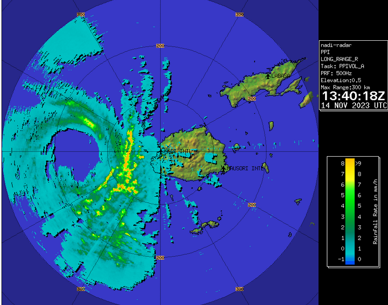
Tropical Cyclone Ana made landfall on the north coast of Viti Levu near Rakiraki on Saturday afternoon. Ana had strengthened to nearly the equivalent of a hurricane/typhoon by the time it made landfall. Radar images from the Fiji Meteorological Service indicated that an eye was beginning to form at the center of Tropical Cyclone Ana before it made landfall. A ring of strong thunderstorms surrounded the forming eye and the strongest winds were occurring in that ring of storms. Bands of showers and thunderstorms were revolving around the center of Ana. Winds to tropical storm force extended out 200 miles (320 km) from the center of circulation.

Tropical Cyclone Ana was producing winds to tropical storm force on Viti Levu and Vanua Levu. Heavy rain was also falling on those islands and flash floods could occur. Gusty winds and heavy rain will spread over Kadavu on Sunday.

An upper level trough east of Australia will produce northwesterly winds which will steer Tropical Cyclone Ana toward the southeast during the next 24 hours. On it anticipated track the center of Ana will cross eastern Viti Levu during the next 12 hours. Tropical Cyclone Ana will pass near Kadavu on Sunday. Ana is expected to pass west of Tonga early next week.

Tropical Cyclone Ana Forms Northwest of Fiji

Tropical Cyclone Ana formed northwest of Fiji on Friday afternoon. At 1:00 p.m. EST on Friday the center of Tropical Cyclone Ana was located at latitude 15.3°S and longitude 175.4°E which put it about 215 miles (345 km) northwest of Nadi, Fiji. Ana was moving toward the east at 13 m.p.h. (20 km/h). The maximum sustained wind speed was 40 m.p.h. (65 km/h) and there were wind gusts to 50 m.p.h. (80 km/h). The minimum surface pressure was 992 mb.

A low pressure system northwest of Fiji strengthened on Friday afternoon and the Fiji Meteorological Service designated the system as Tropical Cyclone Ana. More thunderstorms developed near the center of Ana. Thunderstorms also formed in bands in the eastern half of the tropical cyclone. Bands in the western side of the circulation consisted primarily of showers and lower clouds. Storms near the center began to generate upper level divergence which pumped mass away to the north and east of the tropical cyclone.

Tropical Cyclone Ana will move through an environment favorable for intensification during the next 24 hours. Ana will move over water where the Sea Surface Temperature is near 29°C. It will move under the eastern end of an upper level ridge that is oriented from west to east. The ridge will produce southerly winds which will blow toward the top of the tropical cyclone. Those winds will cause moderate vertical wind shear which will inhibit intensification at times. Tropical Cyclone Ana is likely to intensify during the next 24 hours, but the wind shear could limit strengthening.

Tropical Cyclone Ana will move around the southwestern part of a high pressure system over the South Pacific Ocean. The high will steer Ana toward the southeast during the next 36 hours. On its anticipated track the center of Tropical Cyclone Ana could reach the northern coast of Vita Levu within 36 hours. Ana will bring gusty winds and heavy rain to the Yasawa Group of islands first and then it will bring stormy conditions to Vita Levu and Vanua Levu. Heavy rain could cause flash floods in some locations.

Tropical Cyclone Yasa Passes West of Tonga

Tropical Cyclone Tonga passed west of Tonga on Friday. At 4:00 p.m. EST on Friday the center of Tropical Cyclone Yasa was located at latitude 20.6°S and longitude 178.0°W which put it about 280 miles (305 km) west of Nuku’Alofa, Tonga. Yasa was moving toward the south at 9 m.p.h. (15 km/h). The maximum sustained wind speed was 70 m.p.h. (110 km/h) and there were wind gusts to 85 m.p.h. (135 km/h). The minimum surface pressure was 974 mb.

After making a direct hit on Vanua Levu, Tropical Cyclone Yasa moved over the Fiji islands in the Lau Group. There were reports of damage and casualties from Fiji. Tropical Cyclone Yasa weakened after it made landfall on Vanua Levu. The eye and eyewall were disrupted by passage over land. An upper level low centered north of New Zealand produced northerly winds which blew toward the top of Yasa’s circulation on Friday. Those winds caused moderate vertical wind shear and the shear caused the tropical cyclone to weaken steadily on Friday.

The circulation around Tropical Cyclone Yasa exhibited less organization on Friday. The strongest thunderstorms were occurring in a band in the southern half of the circulation. Bands in the northern half of Yasa consisted primarily of showers and lower clouds. The circulation around Tropical Cyclone Yasa was still large. Winds to tropical storm force extended out 200 miles (320 km) from the center of circulation.

Tropical Cyclone Yasa will move through an environment that is mostly unfavorable for intensification during the next several days. Yasa will move over water where the Sea Surface Temperature is near 27°C. However, the upper level low centered north of New Zealand will continue to cause moderate vertical wind shear. The shear is likely to be strong enough to cause Tropical Cyclone Yasa to continue to weaken.

Tropical Cyclone Yasa will move around the eastern side of the upper level low. The low will steer Yasa toward the southwest during the next 48 hours. On its anticipated track Tropical Cyclone Yasa will pass west of Tonga and it will remain north of New Zealand.