
Tag Archives: Josephine

Subtropical Storm Josephine Develops Off East Coast

Subtropical Storm Josephine developed off the East Coast of the U.S. on Wednesday.  At 5:00 p.m. EDT on Wednesday the center of Subtropical Storm Josephine was located at latitude 37.4°N and longitude 69.5°W which put the center about 265 miles (425 km) south of Nantucket, Massachusetts.  Josephine was moving toward the north at 6 m.p.h. (10 km/h).  The maximum sustained wind speed was 65 m.p.h. (105 km/h) and there were wind gusts to 80 m.p.h. (130 km/h).  The minimum surface pressure was 990 mb.

The U.S. National Hurricane Center designated a low pressure system off the East Coast of the U.S. as Subtropical Storm Josephine on Wednesday afternoon.
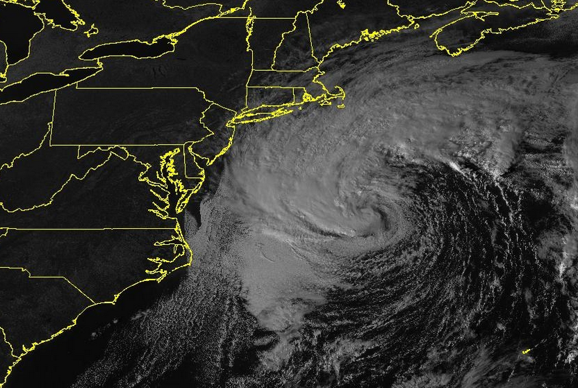
Subtropical Storm Josephine made a transition from an extratropical cyclone to a subtropical cyclone on Wednesday.  The warm front and cold front that had been attached to the low pressure system dissipated.  Even though the fronts had dissipated, the distribution of thunderstorms in Subtropical Storm Josephine was asymmetrical.  Thunderstorms were occurring in bands in the northern and western parts of Josephine’s circulation.  Bands in the eastern and southern parts of Josephine consisted primarily of showers and lower clouds.

The distribution of wind speeds in Subtropical Storm Josephine was also asymmetrical.  Winds to tropical storm force extended out 415 miles (665 km) in the northern half of Josephine’s circulation.  Winds to tropical storm force extended out 150 miles (240 km) in the southern half of Subtropical Storm Josephine.

Subtropical Storm Josephine will move through an environment favorable for the intensification of a subtropical storm during the next 24 hours.  Josephine will move over water where the Sea Surface Temperatures are near 24°C.  It will move under the southeastern part of an upper level trough that will be over the Great Lakes.  The upper level trough will produce southwesterly winds that will blow toward the top of Josephine’s circulation.  Those winds will cause strong vertical wind shear.  However, the upper level winds may also contribute to upper level divergence.  Subtropical Storm Josephine could intensify on Thursday because of the upper level divergence.

The upper level trough over the Great Lakes will steer Subtropical Storm Josephine toward the northeast during the next 24 hours.  On its anticipated track, Subtropical Storm Josephine will pass south of Nova Scotia on Thursday.

Tropical Storm Kyle Forms East of U.S.

Tropical Storm Kyle formed off the East Coast of the U.S. on Friday afternoon.  At 5:00 p.m. EDT on Friday the center of Tropical Storm Kyle was located at latitude 37.7°N and longitude 71.7°W which put it about 185 miles (300 km) southeast of Atlantic City, New Jersey.  Kyle was moving toward the east-northeast at 17 m.p.h. (28 km/h).  The maximum sustained wind speed was 40 m.p.h. (65 km/h) and there were wind gusts to 50 m.p.h. (80 km/h).  The minimum surface pressure was 1008 mb.

Based on data from satellites and surface observations the National Hurricane Center (NHC) determined that a low pressure system off the East Coast of the U.S. possessed characteristics of a tropical cyclone and winds to tropical storm force.  NHC designated the system as Tropical Storm Kyle on Friday afternoon.  Kyle had a well defined low level center of circulation.  Many of the stronger thunderstorms were occurring in bands in the eastern half of Tropical Storm Kyle.  Bands in the western half of the circulation consisted primarily of showers and lower clouds.  Winds to tropical storm force extended out 80 miles to the southeast of the center of circulation.  Winds in the other parts of Kyle were blowing at less than tropical storm force.

Tropical Storm Kyle will move through an environment marginally favorable for intensification during the next 24 hours.  Kyle will move over water where the Sea Surface Temperature is near 27°C.  An upper level trough over eastern Canada and the Great Lakes will produces southwesterly winds which will blow toward the top of tropical storm Kyle.  Those winds will cause moderate vertical wind shear and they will inhibit intensification.  Tropical Storm Kyle could strengthen a little more during the next day or so.

The southwesterly winds will steer Tropical Storm Kyle toward the east-northeast during the next several days.  On its anticipated track Kyle is forecast to pass south of Nova Scotia and Labrador.

Elsewhere over the Atlantic Ocean, Tropical Storm Josephine was spinning east of the northern Leeward Islands.  At 5:00 p.m. EDT on Friday the center of Tropical Storm Josephine was located at latitude 17.8°N and longitude 56.1°E which put it about 460 miles (740 km) east of the northern Leeward Islands.  Josephine was moving toward the west-northwest at 16 m.p.h. (26 km/h).  The maximum sustained wind speed was 40 m.p.h. (65 km/h) and there were wind gusts to 50 m.p.h. (80 km/h).  The minimum surface pressure was 1004 mb.

TD 11 Strengthens to Tropical Storm Josephine

Former Tropical Depression Eleven strengthened to Tropical Storm Josephine on Thursday morning.  At 11:00 a.m. EDT on Thursday the center of Tropical Storm Josephine was located at latitude 13.7°N and longitude 49.2°W which put it about 975 miles (1565 km) east-southeast of the northern Leeward Islands.  Josephine was moving toward the west-northwest at 15 m.p.h. (24 km/h).  The maximum sustained wind speed was 45 m.p.h. (75 km/h) and there were wind gusts to 60 m.p.h. (95 km/h).  The minimum surface pressure was 1005 mb.

Satellite imagery indicated that the circulation around former Tropical Depression Eleven exhibited better organization on Thursday morning and the National Hurricane Center upgraded the system to Tropical Storm Josephine.  Although the circulation around Tropical Storm Josephine was more organized, the distribution of thunderstorms and wind speeds was still asymmetrical.  Many of the stronger thunderstorms were occurring in bands in the northwestern part of Josephine.  Bands in other parts of the tropical storm consisted primarily of showers and lower clouds.  Winds to tropical storm force extended out 80 miles (130 km) on the northern side of Tropical Storm Josephine.  The winds in the southern half of the circulation were mostly weaker than tropical storm force.

Tropical Storm Josephine will move through an environment favorable for intensification during the next day or so.  Josephine will move over water where the Sea Surface Temperature is near 28°C.  It will move through a region where the upper level winds are weak and there will be little vertical wind shear.  Tropical Storm Josephine is forecast to strengthen during the next 24 to 36 hours.

Tropical Storm Josephine will move south of a subtropical high pressure system over the North Atlantic Ocean.  The high will steer Josephine toward the west-northwest during he next several days.  On its anticipated track Tropical Storm Josephine could be near the northern Leeward Islands on Saturday.