
Tropical Storm Atsani passed just south of Taiwan early on Friday. At 4:00 a.m. EST on Friday the center of Tropical Storm Atsani was located at latitude 21.5°N and longitude 120.7°E which put it about 30 miles (50 km) south of Taiwan. Atsani was moving toward the west-northwest at 12 m.p.h. (19 km/h). The maximum sustained wind speed was 60 m.p.h. (95 km/h) and there were wind gusts to 75 m.p.h. (120 km/h). The minimum surface pressure was 995 mb.
The center of Tropical Storm Atsani passed just to the south of the southern tip of Taiwan early on Friday. Radar images from the Taiwan Central Weather Bureau showed the well organized structure of Tropical Storm Atsani.
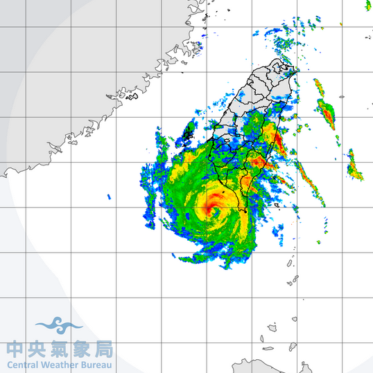
There was a small, tight center of circulation. The center was surrounded by a partial eyewall and the strongest winds were occurring in eyewall. Multiple bands of showers and thunderstorms were revolving around the core of Tropical Storm Atsani. Bands in the northern half of Atsani were dropping heavy rain over the southern half of Taiwan. The heaviest rain was falling in parts of southeastern Taiwan where the wind was pushing air up the eastern slopes of mountains. Flash floods are possible in those areas. Winds to tropical storm force extended out 100 miles (160 km) from the center of Atsani.
Tropical Storm Atsani will be in an environment favorable for intensification during the next 12 to 24 hours. Atsani will move over water where the Sea Surface Temperature is near 28°C. It will be in an area where the upper level winds are weaker and there will be little vertical wind shear. Tropical Storm Atsani could intensify during the next 24 hours and there is a chance it could strengthen into a typhoon. An upper level trough over eastern Asia will approach Atsani during the weekend. The trough will produce stronger southwesterly winds which will cause more vertical wind shear. Tropical Storm Atsani will weaken when the wind shear increases. If the shear is strong enough, the upper level winds could blow the top half of Atsani northeast of the low level circulation.
Tropical Storm Atsani will move south of a ridge of high pressure over the Western North Pacific Ocean. The high will steer Atsani toward the west during the next day or so. If the wind shear blows the top half of Tropical Storm Atsani northeast of the lower level circulation, then a surface high pressure system over eastern Asia could push the lower half of Atsani toward the southeast. On its anticipated track Tropical Storm Atsani will pass southeast of Hong Kong and it could eventually move toward Vietnam.
Elsewhere over the Western North Pacific Ocean, the remnants of former Typhoon Goni were dropping heavy rain over parts of Vietnam. At 4:00 a.m. EST on Friday the center of Tropical Depression Goni was located at latitude 13.8°N and longitude 108.3°E which put it about 50 miles (80 km) west of Quy Nhon, Vietnam. Goni was moving toward the west at 7 m.p.h. (11 km/h). The maximum sustained wind speed was 30 m.p.h. (50 km/h) and there were wind gusts to 40 m.p.h. (65 km/h). The minimum surface pressure was 1003 mb. Tropical Depression Goni is dropping heavy rain over ground that is already saturated and the rain will make ongoing floods worse.