
Hurricane Rachel was spinning over the Eastern North Pacific Ocean south of Baja California on Friday night.
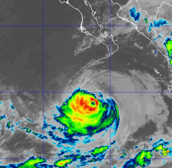
At 11:00 p.m. EDT on Friday the center of Hurricane Rachel was located at latitude 19.4°N and longitude 111.5°W which put the center about 265 miles (425 km) south-southwest of the southern tip of Baja California. Rachel was moving toward the west at 5 m.p.h. (8 km/h). The maximum sustained wind speed was 100 m.p.h. (160 km/h) and there were wind gusts to 120 m.p.h. (195 km/h). The minimum surface pressure was 966 mb.
Hurricane Rachel weakened gradually on Friday. Rachel move over cooler water that was mixed to the surface by the passage of Hurricane Polo last week. The cooler water caused some of the thunderstorms, especially on the northern side of Rachel’s circulation to weaken.
The circulation around Hurricane Rachel was still well organized even though Rachel was a little weaker than it was yesterday. A circular eye was still present at the center of Rachel’s circulation. The eye was surrounded by a ring of thunderstorms and the strongest winds were occurring in that ring of storms. Thunderstorms were also occurring in bands in the southern half of Hurricane Rachel. Bands in the northern side of Rachel’s circulation consisted primarily of showers and lower clouds. Storms near the center of Rachel generated less upper level divergence that pumped less mass away from the hurricane. The removal of mass in he upper levels was less than the convergence of mass in the lower levels of the atmosphere. So, the surface pressure to increased on Friday.
The distribution of winds speeds in Hurricane Rachel was fairly symmetrical . Winds to hurricane force extended out 45 miles (75 km) from the center of Rachel’s circulation. Winds to tropical storm force extended out 150 miles (240 km) from the center of Hurricane Rachel.
Hurricane Rachel will move through an environment unfavorable for intensification during the next 24 hours. Rachel will move over water where the Sea Surface Temperatures are near 27°C. It will move under the southern side of an upper level ridge that is over Baja California. The upper level ridge will produce northeasterly winds that will blow toward the top of Rachel’s circulation. Those winds will cause moderate vertical wind shear. Hurricane Rachel is likely to continue to weaken on Saturday because of the moderate vertical wind shear.
Hurricane Rachel will move around the southern part of a high pressure system that is over the Eastern North Pacific Ocean. The high pressure system will steer Rachel toward the west during the next 24 hours. On its anticipated track, Hurricane Rachel will continue to move farther away from Baja California.
Elsewhere, former Tropical Storm Nolo strengthened back to a hurricane far to the west of Hawaii.
At 11:00 p.m. EDT on Friday the center of Hurricane Nolo was located at latitude 23.4°N and longitude 168.5°W which put the center about 145 miles (230 km) west-southwest of French Frigate Shoals. Nolo was moving toward the west at 7 m.p.h. (11 km/h). The maximum sustained wind speed was 85 m.p.h. (135 km/h) and there were wind gusts to 100 m.p.h. (160 km/h). The minimum surface pressure was 978 mb.
A Tropical Storm Warning is in effect for the Papahanaumokuakea Marine National Monument from French Frigate Shoals to Lisianaki Island including Maro Reef.