
Hurricane Rachel churned westward over the Eastern North Pacific Ocean southwest of Baja California on Monday evening. At 11:00 p.m. EDT on Monday the center of Hurricane Rachel was located at latitude 20.4°N and longitude 117.9°W which put the center about 540 miles (870 km) west-southwest of the southern tip of Baja California. Rachel was moving toward the west at 9 m.p.h. (15 km/h). The maximum sustained wind speed was 90 m.p.h. (145 km/h) and there were wind gusts to 105 m.p.h. (165 km/h). The minimum surface pressure was 973 mb.
A large circular eye with a diameter of 60 miles (96 km) was at the center of Hurricane Rachel.
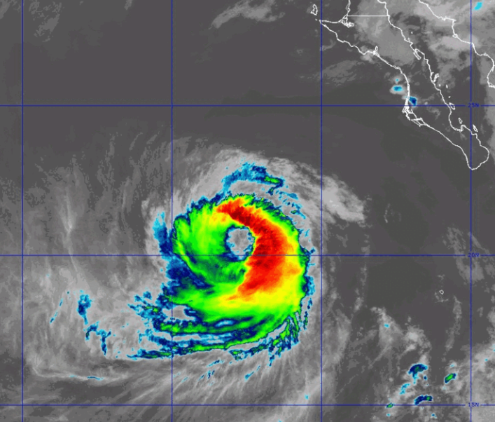
The eye was surrounded by a broken ring of thunderstorms and the strongest winds were occurring in that ring of storms. Thunderstorms were occurring in bands in the eastern and southern part of Rachel’s circulation. Bands in the western and northern parts of Hurricane Rachel consisted primarily of showers and lower clouds. Storms near the center of Rachel still generated upper level divergence that pumped mass away from the hurricane. However, the removal of mass in the upper levels was less than the convergence of mass in the lower levels of the atmosphere. So, the surface pressure increased slowly on Monday.
The distribution of wind speeds in Hurricane Rachel did not change much on Monday. Winds to hurricane force extended out 40 miles (65 km) from the center of Rachel’s circulation. Winds to tropical storm force extended out 140 miles (225 km) from the center of Hurricane Rachel.
Hurricane Rachel will move through an environment that will be unfavorable for intensification during the next 24 hours. Rachel will move over water where the Sea Surface Temperatures are near 26°C. It will move through a region where the upper level winds are weak and there will be little vertical wind shear. However, Rachel will continue to move through a mass of drier air that is west of Baja California. Hurricane Rachel is likely to continue to weaken gradually on Tuesday because of the effects of the drier air.
Hurricane Rachel will move around the southern side of a high pressure system that is over the Eastern North Pacific Ocean. The high pressure system will steer Rachel toward the west during the next 24 hours. On its anticipated track, Hurricane Rachel will continue to move farther away from Baja California.