
Tag Archives: 22E

Vance Weakens to a Tropical Storm

Former Hurricane Vance weakened to a tropical storm on Sunday as it moved over the Eastern North Pacific Ocean south of Mexico.  At 11:00 p.m. EDT on Sunday the center of Tropical Storm Vance was located at latitude 15.0°N and longitude 104.7°W which put the center about 275 miles (445 km) south of Manzanillo, Mexico.  Vance was moving toward the northwest at 7 m.p.h. (11 km/h).  The maximum sustained wind speed was 65 m.p.h. (105 km/h) and there were wind gusts to 80 m.p.h. (130 km/h).  The minimum surface pressure was 995 mb.

Former Hurricane Vance weakened to a tropical storm on Sunday.  An upper level trough over Baja California was producing southwesterly winds that were blowing toward the top of Vance’s circulation.  Those winds were causing strong vertical wind shear.  The strong vertical wind shear caused Vance to weaken to a tropical storm.
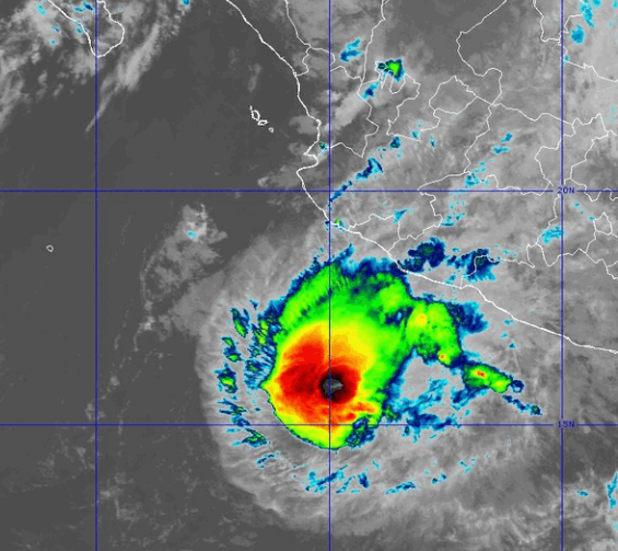
The strong vertical wind shear also caused the distribution of thunderstorms in Tropical Storm Vance to become asymmetrical.  Thunderstorms were still occurring in bands in the northeastern part of Vance’s circulation.  Bands in the other parts of Tropical Storm Vance consisted primarily of showers and lower clouds.  Storms near the center of Vance generated upper level divergence that pumped mass away to the northeast of the tropical storm.  The removal of mass in the upper levels was less than the convergence of mass in the lower levels of the atmosphere.  So, the surface pressure increased on Sunday.

The distribution of wind speeds in Tropical Storm Vance was also asymmetrical.  Winds to tropical storm force extended out 150 miles (240 km) in the northern side of Vance’s circulation.  Winds to tropical storm force extended out 80 miles in the southern side of Tropical Storm Vance.

Tropical Storm Vance will move through an environment that will be unfavorable for intensification during the next 24 hours.  Vance will move over water where the Sea Surface Temperatures are near 29°C.  However, the upper level trough over Baja California will continue to cause strong vertical wind shear.  Tropical Storm Vance is likely to continue to weaken on Monday because of the strong vertical wind shear.

Tropical Storm Vance will move around the western end of a high pressure system that is over Mexico.  The high pressure system will steer Vance slowly toward the northwest during the next 24 hours.  On its anticipated track, Tropical Storm Vance will remain southwest of Mexico for the next several days.
Vance Strengthens to a Hurricane

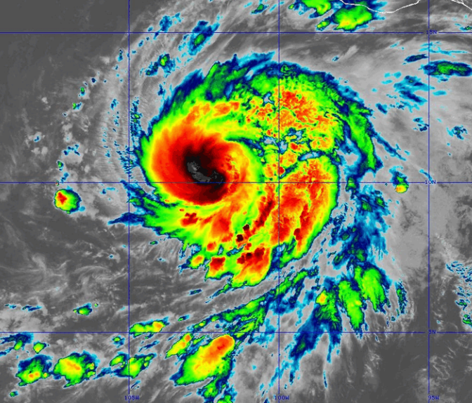
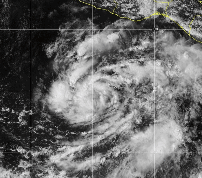
Former Tropical Storm Vance strengthened to a hurricane as it moved over the Eastern North Pacific Ocean south of Mexico on Thursday night.  At 5:00 a.m. EDT on Friday the center of Hurricane Vance was located at latitude 10.9°N and longitude 102.1°W which put the center about 580 miles (930 km) south-southeast of Manzanillo, Mexico.  Vance was moving toward the north-northwest at 6 m.p.h. (10 km/h).  The maximum sustained wind speed was 85 m.p.h. (135 km/h) and there were wind gusts to 100 m.p.h. (160 km/h).  The minimum surface pressure was 982 mb.

Former Tropical Storm Vance strengthened to a hurricane on Thursday night.

The inner end of a rainband wrapped around the center of Hurricane Vance.  An eye appeared to be forming at the center of Vance’s circulation.  Bands of showers and thunderstorms were revolving around the center of Hurricane Vance.  Storms near the center generated upper level divergence that pumped mass away from the hurricane.  The removal of mass caused the surface pressure to decrease.

The strongest winds were occurring in the northern side of Hurricane Vance.  Winds to hurricane force extended out 35 miles (55 km) in the northern half of Vance’s circulation.  Winds to tropical storm force extended out 200 miles (320 km) from the center of Hurricane Vance.

Hurricane Vance will move through an environment favorable for intensification during the next 24 hours.  Vance will move over water where the Sea Surface Temperatures are near 30°C.  It will move through a region where the upper level winds are weak and there will be little vertical wind shear.  Hurricane Vance will intensify during the next 24 hours.  Vance could intensify rapidly at times.  Vance could strengthen to a major by the weekend.

Hurricane Vance will move around the southwestern part of a high pressure system that is over southern Mexico.  The high pressure system will steer Vance toward the north-northwest during the next 24 hours.  On its anticipated track, Hurricane Vance will gradually move closer to the west coast of Mexico.

Tropical Storm Vance Forms South of Mexico

Tropical Storm Vance formed over the Eastern North Pacific Ocean south of Mexico on Wednesday.  At 5:00 p.m. EDT on Wednesday the center of Tropical Storm Vance was located at latitude 9.4°N and longitude 99.8°W which put the center about 520 miles (835 km) south of Acapulco, Mexico.  Vance was moving toward the west at 7 m.p.h. (11 km/h).  The maximum sustained wind speed was 40 m.p.h. (65 km/h) and there were wind gusts to 50 m.p.h. (80 km/h).  The minimum surface pressure was 1003 mb.

A low pressure system over the Eastern North Pacific Ocean south of Mexico strengthened on Wednesday and the U.S. National Hurricane Center designated the system as Tropical Storm Vance.

More thunderstorms developed in bands revolving around the center of Tropical Storm Vance on Wednesday afternoon.  Storms near the center of Vance’s circulation began to generate upper level divergence that pumped mass away from the tropical storm.  The removal of mass caused the surface pressure to decrease.

The strongest winds were occurring in the northern side of Tropical Storm Vance.  Winds to tropical storm force extended out 70 miles (110 km) in the northern side of Vance’s circulation.  The winds in the southern part of Tropical Storm Vance were blowing at less than tropical storm force.

Tropical Storm Vance will move through an environment favorable for intensification during the next 24 hours.  Vance will move over water where the Sea Surface Temperatures are near 30°C.  It will move through a region where the upper level winds are weak and there will be little vertical wind shear.  Tropical Storm Vance will intensify during the next 24 hours.  Vance could strengthen to a hurricane on Thursday.

Tropical Storm Vance will move around the southwestern part of a high pressure system that is over southern Mexico.  The high pressure system will steer Vance toward the northwest during the next 24 hours.  On its anticipated track, Tropical Storm Vance will start to move closer to the west coast of Mexico on Thursday.

Tropical Storm Tara Develops South of Manzanillo

Tropical Storm Tara developed south of Manzanillo, Mexico on Monday.  At 11:00 a.m. EDT on Monday the center of Tropical Storm Tara was located at latitude 17.6°N and longitude 104.4°W which put it about 95 miles (155 km) south of Manzanillo, Mexico.  Tara was moving toward the west-northwest at 2 m.p.h. (3 km/h).  The maximum sustained wind speed was 45 m.p.h. (75 km/h) and there were wind gusts to 60 m.p.h. (95 km/h).  The minimum surface pressure was 1001 mb.  A Tropical Storm Watch was in effect for the portion of the coast from Punta San Telmo to Cabo Corrientes, Mexico.

The circulation around Tropical Storm Tara is still organizing.  More thunderstorms are developing near the center of circulation.  Several bands of showers and thunderstorms are beginning to form around the center.  Storms near the center are starting to generate upper level divergence which is pumping mass away to the east of the tropical storm.  The circulation around  Tropical Storm Tara is small.  Winds to tropical storm force only extend out about 35 miles (55 km) from the center of circulation.

Tropical Storm Tara will be in an environment somewhat favorable for intensification.  Tara will move over water where the Sea Surface Temperature is near 29°C.  An upper level trough near Baja California will produce southwesterly winds which will blow toward the top of the circulation.  Those winds will cause some vertical wind shear which will inhibit intensification.  The wind shear will not stop intensification, but they will slow it.  Tropical Storm Tara will remain close to Mexico and there is a chance that drier air from land could enter the northern part of the circulation.  Tropical Storm Tara is forecast to strengthen gradually.  However, because the circulation around Tropical Storm Tara is small, it could intensify or weaken very quickly if the environmental conditions change.

Tropical Storm Tara will be in an area where the steering currents are weak for another day or two.  Tara is forecast to move slowly toward the west-northwest during the next 24 to 48 hours.  On its anticipated track Tropical Storm Tara will remain west of Mexico.  However, several forecast models predict that Tara will move more northward and make landfall west of Manzanillo.  The government of Mexico issued a Tropical Storm Watch for that portion of the coast in case Tara brings tropical storm force winds to the coast.

Sandra Weakens to a Tropical Storm

Strong vertical wind shear weakened Hurricane Sandra to a tropical storm on Friday.  At 10:00 p.m. EST on Friday the center of Tropical Storm Sandra was located at latitude 21.2°N and longitude 108.8°W which put it about 155 miles (250 km) west of Las Islas Marias and about 205 miles (330 km) southwest of Mazatlan, Mexico.  Sandra was moving toward the north at 10 m.p.h. (16 km/h).  The maximum sustained wind speed was 65 m.p.h. (105 km/h) and there were wind gusts to 80 m.p.h. (130 km/h).  The minimum surface pressure was 990 mb.  Tropical Storm Warnings are in effect for the portion of the coast from Altata to San Blas, Mexico and for the Las Islas, Marias.

A large upper level trough centered over the southwestern U.S. generated strong southwesterly winds that blew the top half of Hurricane Sandra east of the low level circulation.  The strong wind vertical wind shear will continue, but it will take another day or two for the low level circulation to spin down.  Sandra could weaken to a tropical depression on Saturday and it could be classified as a remnant low by the end of the weekend.

Since the upper portion of the circulation is detached from the lower portion, the surface circulation is being steered by the winds in the lower atmosphere.  A ridge in the lower atmosphere is steering the surface circulation toward the north and that general motion is expected to continue for the next 24 to 48 hours.  On its anticipated track the surface center of Tropical Storm Sandra will pass near the southern tip of Baja California on Saturday.  The surface center could make landfall on the west coast of Mexico on Sunday.

Hurricane Sandra Turns Toward Mexico

Hurricane Sandra moved around the western end of a subtropical ridge and turned toward Mexico on Thursday.  At 10:00 p.m. EST on Thursday the center of Hurricane Sandra was located at latitude 18.0°N and longitude 109.7°W which put it about 340 miles (545 km) south of the southern tip of Baja California and about 490 miles (790 km) south-southwest of Culiacan, Mexico.  Sandra was moving toward the north at 13 m.p.h. (20 km/h).  The maximum sustained wind speed was 120 m.p.h. (195 km/h) and there were wind gusts to 150 m.p.h. (240 km/h).  The minimum surface pressure was 956 mb.  The government of Mexico issued a Tropical Storm Watch for the coast of Baja California from Todos Santos to Los Barriles.

Hurricane Sandra appeared to develop concentric eyewalls on Thursday.  A primary rainband wrapped around the tiny pinhole eye at the center of the hurricane.  Satellite imagery suggests that the tiny inner eye still exists inside the larger outer eye.  Sandra reached Category 4 on the Saffir-Simpson Scale on Thursday morning, but the formation of concentric eyewalls weakened the hurricane back to Category 3 later in the day.  Sandra remains a well organized hurricane.  It has a well defined core surrounded by a ring of strong thunderstorms.  Spiral bands of storms are in the northeastern quadrant of the circulation.

Hurricane Sandra will move into a less favorable environment on Friday.  It will be over water where the Sea Surface Temperature is near 29°C.  However, a large upper level trough along the west coast of North America will generate strong southwesterly winds.  Those winds will cause strong vertical wind shear, which will tilt the circulation toward the northeast.  The upper level winds will also inhibit upper level divergence from the western part of Sandra.  The strong wind shear will weaken Hurricane Sandra on Friday.  Some models are predicting that the shear could be strong enough to blow the middle and upper parts of the circulation northeast of the low level circulation.  If that happens, then Hurricane Sandy could weaken very quickly,

The upper level trough will steer Hurricane Sandra toward the northeast on Friday.  Sandra will likely move faster toward the northeast by Friday night.  On its anticipated track Sandra could be near the southern tip of Baja California by Friday night and it could approach the west coast of Mexico on Saturday.  Sandra could still be a hurricane when it nears Baja California, but it is more likely to be a tropical storm.  It could be a tropical storm or depression by the time it reaches the west coast of Mexico.

Sandra Quickly Intensifies into a Major Hurricane

Hurricane Sandra intensified quickly into a major hurricane on Wednesday.  At 4:00 p.m. EST on Wednesday the center of Hurricane Sandra was located at latitude 13.0°N and longitude 109.9°W which put it about 685 miles (1100 km) south of the southern tip of Baja California.  Sandra was moving toward the northwest at 8 m.p.h. (13 km/h).  The maximum sustained wind speed was 115 m.p.h. (185 km/h) which made Sandra a Category 3 hurricane on the Saffir-Simpson Scale and qualified it as a major hurricane.  There were wind gusts to 140 m.p.h. (225 km/h) and the minimum surface pressure was 967 mb.  Sandra is the ninth major hurricane to form over the Eastern North Pacific during 2015, which is a new record for that basin.

Sandra is a small well organized hurricane.  It has a well defined eye surrounded by a ring of thunderstorms, but hurricane force winds only extend out about 25 miles (40 km) from the center.  Thunderstorms in the core of Sandra are producing upper level divergence which is pumping out mass and allowing the surface pressure to decrease.  Sandra is an environment that favors further intensification.  It is over water where the Sea Surface Temperature is near 30°C.  The upper level winds are light and there is not much vertical wind shear.  Sandra could become a Category 4 hurricane on Thursday.

Hurricane Sandra is moving around the western end of a subtropical ridge to the east of it.  Sandra turned toward the northwest on Wednesday and it will gradually start moving more toward the north on Thursday.  A large deepening upper level trough off the west coast of North American will create southwesterly winds that will start to steer Sandra toward the northeast on Friday.  On its anticipated track Hurricane Sandra will approach the southern tip of Baja California on Friday night.

TD 22E Intensifies to Tropical Storm Sandra

A core circulation organized quickly on Tuesday inside Tropical Depression 22E and it intensified into Tropical Storm Sandra.  At 4:00 p.m. EST on Tuesday the center of Tropical Storm Sandra was located at latitude 11.9°N and longitude 107.2°W which put it about 780 miles south-southeast of the southern tip of Baja California.  Sandra was moving toward the west-northwest at 14 m.p.h. (22 km/h).  The maximum sustained wind speed was 65 m.p.h. (105 km/h) and there were gusts to 80 m.p.h. (130 km/h).  The minimum surface pressure was 997 mb.

Eastern upper level winds which were blowing over the top of Tropical Depression 22E diminished on Tuesday and the depression intensified into Tropical Storm Sandra.  A primary rainband wrapped around the center of circulation  and an inner core developed near the interior end of the band.  As the band wrapped around the center of circulation a ring of thunderstorms began to take on the structure of an eyewall.  Those thunderstorms also started to generate some upper level divergence.  The circulation of Sandra is still organizing and other spiral bands are starting to form.

Tropical Storm Sandra is in an environment that is favorable for intensification.  It is over water where the Sea Surface Temperature is near 30°C.  Although there is still some vertical wind shear, it is much less than it was on Monday.  A combination of very warm water and little vertical wind shear could allow Sandra to intensify very quickly.  It is likely to become a hurricane with 12 to 18 hours and it could become a major hurricane within 24 to 36 hours.  In a couple of days Sandra will start to encounter strong upper level winds from the southwest.  The increased vertical wind shear at that time will cause it to weaken.

Tropical Storm Sandra is starting to move around the western end of a subtropical ridge that has been steering toward the north.  Sandra should gradually turn toward the north during the next 24 hours.  It is likely to move mainly toward the north until Thursday when southwesterly winds will turn it toward the northeast.  Sandra could be approaching the southern tip of Baja California by Friday night.

Tropical Depression 22E Forms Southwest of Mexico

A small center of circulation formed within a larger area of thunderstorms southwest of Mexico on Monday and the National Hurricane Center designated the system as Tropical Depression 22E.  At 4:00 p.m. EST on Monday the center of Tropical Depression 22E (TD22E) was located at latitude 10.8°N and longitude 102.9°W which put it about 465 miles (750 km) south-southwest of Acapulco, Mexico.  TD22E was moving toward the west at 18 m.p.h. (30 km/h).  The maximum sustained wind speed was 35 m.p.h. (55 km/h) and there were gusts to 45 m.p.h. (70 km/h).  The minimum surface pressure was 1005 mb.

TD22E is still in the early stages of an organizational process.  The small center of circulation is located near the western end of a long band of thunderstorms.  There are not many thunderstorms south and west of the center and there is not much evidence of spiral bands.  A subtropical ridge northeast of TD22E is pushing the depression quickly toward the west and its rapid movement is retarding the organizational process.

TD22E is currently in an environment that is marginal for intensification.  It is over water where the Sea Surface Temperature (SST) is near 30°C, which is very favorable for intensification.  However, the ridge northeast of TD22E is causing strong easterly winds to blow over the top of the depression.  The strong vertical wind shear and the rapid motion of the depression are negative factors for intensification.

As TD22E moves farther west, the vertical wind shear is expected to decrease and the depression is expected to move more slowly.  When that happens, TD22E will be able to more efficiently use the energy it is getting from the warm water and it will intensify.  A period of rapid intensification may occur once the core of the circulation is better organized.  TD22E could become a tropical storm on Tuesday and it could become a hurricane later this week.

The subtropical ridge is steering TD22E quickly toward the west.  In another 24 to 36 hours TD22E is likely to reach the western end of the ridge.  At that time it will slow down and turn toward the north.  TD22E will encounter southwesterly winds when it moves farther north.  Those winds will push TD22E toward the northeast later this week.  On its anticipated track TD22E could be near the southern tip of Baja California by the end of the week.