
Hurricane Trudy moved closer to the west coast of Mexico on Saturday. At 5:00 p.m. EDT on Saturday the center of Hurricane Trudy was located at latitude 17.5°N and longitude 105.0°W which put the center about 115 miles (185 km) south-southwest of Manzanillo, Mexico. Trudy was moving toward the northwest at 10 m.p.h. (16 km/h). The maximum sustained wind speed was 100 m.p.h. (160 km/h) and there were wind gusts to 120 m.p.h. (195 km/h). The minimum surface pressure was 976 mb.
A Hurricane Warning is in effect for the portion of the coast from Manzanillo to Cabo Corrientes, Mexico.
A Hurricane Watch is in effect for the portion of the coast from Manzanillo to Punta San Telmo, Mexico.
A Tropical Storm Warning is in effect for the portion of the coast from Manzanillo to Lazaro Cardenas, Mexico.
A Tropical Storm Warning is in effect for the portion of the coast from Cabo Corrientes to San Blas, Mexico.
A Tropical Storm Warning is in effect for Las Islas Marias.
Hurricane Trudy appeared to go through an eyewall replacement cycle during the past 24 hours.
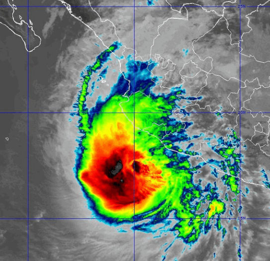
A circular eye with a diameter of 45 miles (75 km) was at the center of Trudy’s circulation. The eye was surrounded by a ring of thunderstorms and the strongest winds were occurring in that ring of storms. Bands of showers and thunderstorms were revolving around the core of Trudy’s circulation. Storms near the core of Trudy generated upper level divergence that pumped mass away from the hurricane. The removal of mass in the upper levels was less than the convergence of mass in the lower levels of the atmosphere. So the surface pressure increased on Saturday.
The distribution of wind speeds in Hurricane Trudy was fairly symmetrical. Winds to hurricane force extended out 35 miles (55 km) from the center of Trudy’s circulation. Winds to tropical storm force extended out 140 miles (225 km) from the center of Hurricane Trudy.
The Hurricane Intensity Index (HII) for Hurricane Trudy is 16.5. The Hurricane Size Index (HSI) is 12.6 and the Hurricane Wind Intensity Size Index (HWISI) is 29.1. Hurricane Trudy is similar in intensity to Hurricane Idalia when Idalia hit Florida in 2023. Trudy is larger than Isaias was.
Hurricane Trudy will move through an environment that will be somewhat favorable for intensification during the next 24 hours. Trudy will move over water where the Sea Surface Temperatures are near 30°C. It will move under the southeastern part of an upper level trough that is near Baja California. The upper level trough will produce westerly winds that will blow toward the top of Trudy’s circulation. Those winds will cause the vertical wind shear to increase. Hurricane Trudy could intensify on Sunday if the vertical wind shear does not increase too much.
Hurricane Trudy will move around the western side of a high pressure system that is over Mexico. The high pressure system will steer Trudy toward the northwest during the next 24 hours. On its anticipated track, the center of Hurricane Trudy will approach the west coast of Mexico between Manzanillo and Cabo Corrientes.
The center of Hurricane Trudy is forecast to remain west of Mexico. However, bands in the eastern side of Trudy’s circulation will bring strong winds and heavy rain to the west coast of Mexico between Manzanillo and Cabo Corrientes. Heavy rain is likely to cause flash floods in some locations.