Tag Archives: 12E

Hurricane Lowell Intensifies to Cat. 5

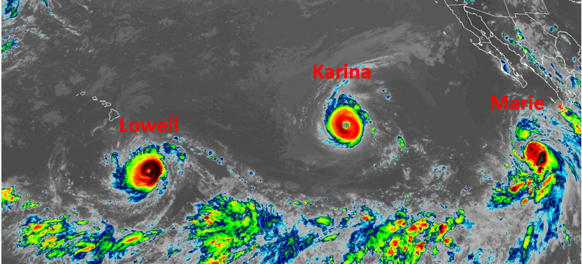
Hurricane Lowell intensified to Category 5 on the Saffir-Simpson Scale as it moved south of Hawaii on Wednesday.  At 5:00 p.m. EDT on Wednesday the center of Hurricane Lowell was located at latitude 13.3°N and longitude 154.3°W which put the center about 445 miles (715 km) south Hilo, Hawaii.  Lowell was moving toward the west at 10 m.p.h. (16 km/h).  The maximum sustained wind speed was 160 m.p.h. (260 km/h) and there were wind gusts to 190 m.p.h. (305 km/h).  The minimum surface pressure was 927 mb.

Hurricane Lowell intensified to Category 5 on the Saffir-Simpson Scale on Wednesday.  A circular eye with a diameter of 17 miles (28 km) was at the center of Lowell’s circulation the eye was surrounded by a ring of thunderstorms and the strongest winds were occurring in that ring of storms.  Bands of showers and thunderstorms were revolving around the center of Hurricane Lowell.  Storms near the center generated upper level divergence that pumped mass away from the hurricane.  The removal of mass caused the surface pressure to decrease.
The circulation around Hurricane Lowell was small.  Winds to hurricane force extended out 35 miles (55 km) from the center of Lowell’s circulation.  Winds to tropical storm force extended out 90 miles (145 km) from the center of Hurricane Lowell.

The Hurricane Intensity Index (HII) for Hurricane Lowell is 35.0.  The Hurricane Size Index (HSI) is 11.5 and the Hurricane Wind Intensity Size Index (HWISI) is 46.5.  Hurricane Lowell is similar in intensity to Hurricane MIchael when Michael hit Northwest Florida in 2018.  Lowell is a little smaller than Michael was.

Hurricane Lowell will move through an environment favorable for a strong hurricane during the next 24 hours.  Lowell will move over water where the Sea Surface Temperatures are near 28°C.  It will move through a region where the upper level winds are weak and there will be little vertical wind wind shear.  Hurricane Lowell could intensify during the next 24 hours unless an eyewall replacement cycle occurs.

Hurricane Lowell will move around the southern side of a high pressure system that is over the Central North Pacific Ocean.  The high pressure system will steer Lowell toward the west during the next 24 hours.  On its anticipated track, Hurricane Lowell will remain south of Hawaii on Thursday.

Elsewhere, Major Hurricane Karina continued to move westward and Tropical Storm Marie intensified gradually on Wednesday.

At 5:00 p.m. EDT on Wednesday the center of Hurricane Karina was located at latitude 18.9°N and longitude 133.8°W which put the center about 1390 miles (2235 km) east of Hilo, Hawaii.   Karina was moving toward the west-northwest at 12 m.p.h. (19 km/h).  The maximum sustained wind speed was 140 m.p.h. (225 km/h) and there were wind gusts to 165 m.p.h. (265 km/h).  The minimum surface pressure was 943 mb.

At 5:00 p.m. EDT on Wednesday the center of Tropical Storm Marie was located at latitude 18.0°N and longitude 112.5°W which put the center about 380 miles (610 km) south-southwest of the southern tip of Baja California.  Marie was moving toward the northwest at 12 m.p.h. (19 km/h).  The maximum sustained wind speed was 70 m.p.h. (110 km/h) and there were wind gusts to 85 m.p.h. (135 km/h).  The minimum surface pressure was 992 mb.
Tropical Storm Marie Forms Southwest of Mexico

Tropical Storm Marie formed over the Eastern North Pacific Ocean southwest of Mexico on Tuesday.  At 11:00 p.m. EDT on Tuesday the center of Tropical Storm Marie was located at latitude 16.1°N and longitude 110.3°W which put the center about 470 miles (755 km) south of the southern tip of Baja California.  Marie was moving toward the northwest at 9 m.p.h. (15 km/h).  The maximum sustained wind speed was 65 m.p.h. (105 km/h) and there were wind gusts to 80 m.p.h. (130 km/h).  The minimum surface pressure was 994 mb.

A low pressure system over the Eastern North Pacific Ocean southwest of Mexico strengthened on Tuesday and the U.S. National Hurricane Center designated the system as Tropical Storm Marie.

Tropical Storm Marie intensified steadily on Tuesday.  Numerous thunderstorms developed near the center of Marie’s circulation.  Bands of showers and thunderstorms were revolving around the center of Tropical Storm Marie.  Storms near the center of Marie generated upper level divergence that pumped mass away from the tropical storm.  The removal of mass caused the surface pressure to decrease.

The circulation around Tropical Storm Marie was large.  Winds to tropical storm force extended out 185 miles (295 km) from the center of Marie’s circulation.

Tropical Storm Marie will move through an environment that will be favorable for intensification during the next 24 hours.  Marie will move over water where the Sea Surface Temperatures are near 29°C.  It will move through a region where the upper level winds are weak and there will be little vertical wind wind shear.  Tropical Storm Marie will intensify during the next 24 hours.  Marie could intensify rapidly at times.  Tropical Storm Marie will strengthen to a hurricane on Wednesday.

Tropical Storm Marie will move around the southwestern side of a high pressure system that is centered over the southwest U.S.  The high pressure system will steer Marie toward the northwest during the next 24 hours.  On its anticipated track, Tropical Storm Marie will move southwest of Baja California.

Elsewhere, Hurricane Lowell rapidly intensified to a major hurricane south-southeast of Hawaii and Hurricane Karina continued to be Category 4 hurricane on the Saffir-Simpson Scale.

At 11:00 p.m. EDT on Tuesday the center of Hurricane Lowell was located at latitude 13.5°N and longitude 151.2°W which put the center about 500 miles (805 km) south-southeast Hilo, Hawaii.  Lowell was moving toward the west at 10 m.p.h. (16 km/h).  The maximum sustained wind speed was 130 m.p.h. (210 km/h) and there were wind gusts to 155 m.p.h. (250 km/h).  The minimum surface pressure was 953 mb.

At 11:00 p.m. EDT on Tuesday the center of Hurricane Karina was located at latitude 18.3°N and longitude 130.8°W which put the center about 1385 miles (2230 km) west of the southern tip of Baja California.  Karina was moving toward the west at 12 m.p.h. (19 km/h).  The maximum sustained wind speed was 140 m.p.h. (225 km/h) and there were wind gusts to 165 m.p.h. (265 km/h).  The minimum surface pressure was 946 mb.

Karina and Lowell Churn Westward

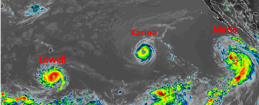
Hurricane Karina and Tropical Storm Lowell were churning westward over the North Pacific Ocean on Monday evening.

At 11:00 p.m. EDT on Monday the center of Hurricane Karina was located at latitude 17.8°N and longitude 126.6°W which put the center about 1135 miles (1830 km) west-southwest of the southern tip of Baja California.  Karina was moving toward the west-northwest at 9 m.p.h. (15 km/h).  The maximum sustained wind speed was 130 m.p.h. (210 km/h) and there were wind gusts to 155 m.p.h. (250 km/h).  The minimum surface pressure was 950 mb.

Hurricane Karina maintained its intensity on Monday as it churned west over the Eastern North Pacific Ocean.  A circular eye with a diameter of 12 miles (19 km) was at the center of Karina’s circulation.  The eye was surrounded by a ring of thunderstorms and the strongest winds were occurring in that ring of storms.  Bands of showers and thunderstorms were revolving around the core of Karina’s circulation.  Storms near the core of Karina generated upper level divergence that pumped large amounts of mass away from the hurricane. The removal of mass in the upper levels was nearly equal to the convergence of mass in the lower levels of the atmosphere.  So, the surface pressure was nearly constant on Monday.

The distribution of wind speeds in Hurricane Karina was fairly symmetrical.  Winds to hurricane force extended out 30 miles (50 km) from the center of Karina’s circulation.  Winds to tropical storm force extended out 115 miles (185 km) from the center of Hurricane Karina.

Hurricane Karina will move through an environment favorable for a strong hurricane during the next 24 hours.  Karina will move over water where the Sea Surface Temperatures are near 28°C.  It will move through a region where the upper level winds are weak and there will be little vertical wind shear.  Hurricane Karina is likely to maintain its intensity on Tuesday.

Hurricane Karina will move around the southern part of a high pressure system that is over the Eastern North Pacific Ocean.  The high pressure system will steer Karina toward the west-northwest during the next 24 hours.  On its anticipated track, Hurricane Karina will continue to move farther away from Baja California.

Elsewhere, Tropical Storm Lowell intensified gradually on Monday.  At 11:00 p.m. EDT on Monday the center of Tropical Storm Lowell was located at latitude 13.0°N and longitude 147.4°W which put the center about 690 miles (1110 km) southeast Hilo, Hawaii.  Lowell was moving toward the west at 10 m.p.h. (16 km/h).  The maximum sustained wind speed was 70 m.p.h. (110 km/h) and there were wind gusts to 85 m.p.h. (135 km/h).  The minimum surface pressure was 993 mb.

Karina Rapidly Intensifies to a Major Hurricane

Hurricane Karina rapidly intensified to a major hurricane on Sunday evening as it moved over the Eastern North Pacific Ocean southwest of Baja California.  At 8:00 p.m. EDT on Sunday the center of Hurricane Karina was located at latitude 17.2°N and longitude 123.4°W which put the center about 960 miles (1545 km) west-southwest of the southern tip of Baja California.  Karina was moving toward the west at 9 m.p.h. (15 km/h).  The maximum sustained wind speed was 125 m.p.h. (200 km/h) and there were wind gusts to 150 m.p.h. (240 km/h).  The minimum surface pressure was 955 mb.

Hurricane Karina rapidly intensified to a major hurricane on Sunday evening.  The inner end of a rainband wrapped around the center of Karina’s circulation.  A circular eye with a diameter of 25 miles (40 km) formed at the center of Hurricane Karina.  The eye was surrounded by a ring of thunderstorms and the strongest winds were occurring in that ring of storms.  Bands of showers and thunderstorms were revolving around the core of Karina’s circulation.  Storms near the core of Karina generated strong upper level divergence that pumped large amounts of mass away from the hurricane.  The removal of large amounts of mass caused the surface pressure to decrease rapidly.

The inner core of Hurricane Karina was very small.  Winds to hurricane force extended out 15 miles (25 km) from the center of Karina’s circulation.  Winds to tropical storm force extended out 205 miles (335 km) from the center of Hurricane Karina.

Hurricane Karina will move through an environment mostly favorable for intensification during the next 24 hours.  Karina will move over water where the Sea Surface Temperatures are near 29°C.  It will move through a region where the upper level winds are weak and there will be little vertical wind shear.  However, there is a mass of drier air just to the west and north of Hurricane Karina.  The drier air will inhibit intensification of Karina, but the drier air probably will not be enough to prevent intensification.  Hurricane Karina is likely to intensify during the next 24 hours.  Karina could continue to intensify rapidly during the next few hours, if the drier air does not get pulled into its circulation.

Hurricane Karina will move around the southern part of a high pressure system that is over the Eastern North Pacific Ocean.  The high pressure system will steer Karina toward the west-northwest during the next 24 hours.  On its anticipated track, Hurricane Karina will move farther away from Baja California.

Elsewhere, Tropical Storm Lowell moved over the Central Pacific Ocean.  At 5:00 p.m. EDT on Sunday the center of Tropical Storm Lowell was located at latitude 13.3°N and longitude 141.8°W which put the center about 985 miles (1585 km) east-southeast Hilo, Hawaii.  Lowell was moving toward the west at 13 m.p.h. (21 km/h).  The maximum sustained wind speed was 50 m.p.h. (80 km/h) and there were wind gusts to 65 m.p.h. (105 km/h).  The minimum surface pressure was 999 mb.

Karina Strengthens to a Hurricane

Former Tropical Storm Karina strengthened to a hurricane as it moved over the Eastern North Pacific Ocean southwest of Baja California on Saturday night.  At 5:00 a.m. EDT on Sunday the center of Hurricane Karina was located at latitude 17.3°N and longitude 121.1°W which put the center about 820 miles (1325 km) west-southwest of the southern tip of Baja California.  Karina was moving toward the west-northwest at 15 m.p.h. (24 km/h).  The maximum sustained wind speed was 80 m.p.h. (130 km/h) and there were wind gusts to 100 m.p.h. (160 km/h).  The minimum surface pressure was 980 mb.

Former Tropical Storm Karina strengthened to a hurricane on Saturday night.  The inner end of a rainband wrapped around the western and southern sides of the center of Karina’s circulation.  An eye appeared to be forming at the center of Hurricane Karina.

The distribution of thunderstorms in Hurricane Karina was asymmetrical.  Thunderstorms were mostly occurring in bands in the southern half of Karina’s circulation.  Bands in the northern half of Hurricane Karina consisted primarily of showers and lower clouds.  Storms near the center of Karina generated upper level divergence that pumped mass away from the hurricane.  The removal of mass caused the surface pressure to decrease.

The strongest winds were occurring in the northeastern part of Hurricane Karina.  Winds to hurricane force extended out 25 miles (40 km) in the northeastern quadrant of Karina’s circulation.  Winds to tropical storm force extended out 230 miles (370 km) from the center of Hurricane Karina.

Hurricane Karina will move through an environment mostly favorable for intensification during the next 24 hours.  Karina will move over water where the Sea Surface Temperatures are near 28°C.  It will move through a region where the upper level winds are weak and there will be little vertical wind shear.  However, there is a mass of drier air just to the west and north of Hurricane Karina.  The drier air will inhibit intensification of Karina, but the drier air probably will not be enough to prevent intensification.  Hurricane Karina is likely to intensify during the next 24 hours.  Karina could intensify rapidly at times, if the drier air does not get pulled into its circulation.  Karina strengthen to a major hurricane by Monday morning.

Hurricane Karina will move around the southern part of a high pressure system that is over the Eastern North Pacific Ocean.  The high pressure system will steer Karina toward the west-northwest during the next 24 hours.  On its anticipated track, Hurricane Karina will move farther away from Baja California.

Elsewhere over the Eastern North Pacific Ocean, Tropical Storm Lowell was moving west toward the Central Pacific.  At 5:00 a.m. EDT on Sunday the center of Tropical Storm Lowell was located at latitude 13.2°N and longitude 139.1°W which put the center about 1150 miles (1850 km) east-southeast Hilo, Hawaii.  Lowell was moving toward the west at 10 m.p.h. (16 km/h).  The maximum sustained wind speed was 50 m.p.h. (80 km/h) and there were wind gusts to 65 m.p.h. (105 km/h).  The minimum surface pressure was 1000 mb.

Tropical Storms Karina and Lowell Form over Eastern North Pacific

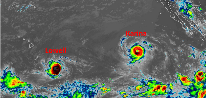
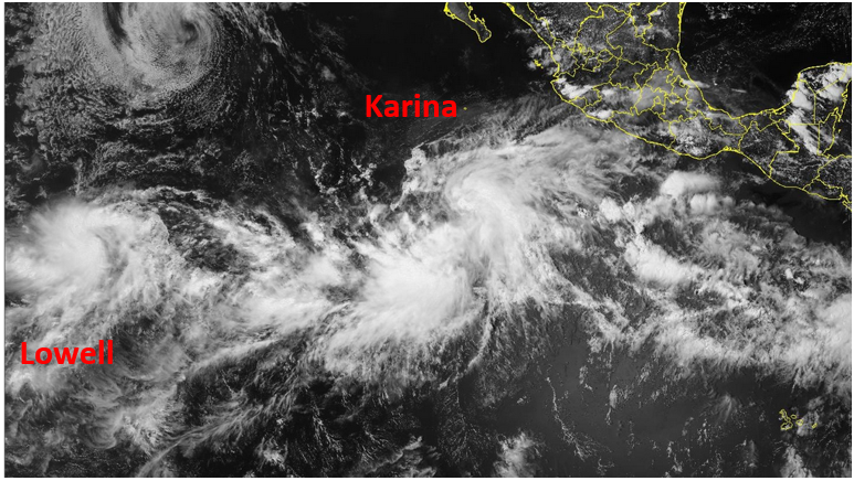
Tropical Storms Karina and Lowell formed over the Eastern North Pacific Ocean on Thursday afternoon.  At 5:00 p.m. EDT on Thursday the center of Tropical Storm Karina was located at latitude 11.1°N and longitude 111.9°W which put the center about 825 miles (1330 km) south of the southern tip of Baja California.  Karina was moving toward the west-northwest at 13 m.p.h. (21 km/h).  The maximum sustained wind speed was 45 m.p.h. (75 km/h) and there were wind gusts to 60 m.p.h. (95 km/h).  The minimum surface pressure was 1001 mb.

Two low pressure systems over the Eastern North Pacific Ocean strengthened on Thursday afternoon and the U.S. National Hurricane Center designated the systems as Tropical Storm Karina and Tropical Storm Lowell.

Thunderstorms were developing in bands in the southern and eastern parts of Tropical Storm Karina.  Bands in the northwestern part of Karina’s circulation consisted primarily of showers and lower clouds.  Storms near the center of Karina generated upper level divergence that pumped mass away from the tropical storm.  The removal of mass caused the surface pressure to decrease.

The strongest winds were occurring in the northern part of Tropical Storm Karina.  Winds to tropical storm force extended out 205 miles (335 km) in the northern side of Karina’s circulation.  The winds in the southern side of Tropical Storm Karina were blowing at less than tropical storm force.

Tropical Storm Karina will move through an environment favorable for intensification during the next 24 hours.  Karina will move over water where the Sea Surface Temperatures are near 29°C.  It will move through a region where the upper level winds are weak and there will be little vertical wind shear.  Tropical Storm Karina will intensify during the next 24 hours.  Karina could strengthen to a hurricane by Saturday morning.

Tropical Storm Karina will move around the southwestern part of a high pressure system that is centered over the Southwest U.S.  The high pressure system will steer Karina toward the northwest during the next 24 hours.  On its anticipated track, Tropical Storm Karina will move far to the southwest of Baja California.

At 5:00 p.m. EDT on Thursday the center of Tropical Storm Lowell was located at latitude 11.3°N and longitude 133.8°W which put the center about 1765 miles (2840 km) west-southwest of the southern tip of Baja California.  Lowell was moving toward the east-northeast at 5 m.p.h. (8 km/h).  The maximum sustained wind speed was 40 m.p.h. (65 km/h) and there were wind gusts to 50 m.p.h. (80 km/h).  The minimum surface pressure was 1006 mb.

Tropical Storm Lowell is forecast to move west toward the Central North Pacific Ocean and to strengthen to a hurricane during the weekend.

Typhoon Dolphin Hits Eastern China

Typhoon Dolphin hit the coast of eastern China near Wenzhou early on Sunday.  At 5:00 a.m. EDT on Sunday the center of Typhoon Dolphin was located at latitude 28.2°N and longitude 121.4°E which put the center about 50 miles (80 km) east of Wenzhou, China.  Dolphin was moving toward the west-northwest at 14 m.p.h. (22 km/h).  The maximum sustained wind speed was 85 m.p.h. (135 km/h) and there were wind gusts to 105 m.p.h. (165 km/h).  The minimum surface pressure was 954 mb.

Typhoon Dolphin made landfall on the east coast of China near Wenzhou early on Sunday.  Dolphin was a large typhoon.  Winds to typhoon force extended out 35 miles (55 km) from the enter of Dolphin’s circulation.  Winds to tropical storm force extended out 295 miles (475 km) from the center of Typhoon Dolphin.

The Hurricane Intensity Index (HII) for Typhoon Dolphin is 12.7.  The Hurricane Size Index (HSI) is 16.7 and the Hurricane Wind Intensity Size Index (HWISI) is 29.4.  Typhoon Dolphin is similar in intensity to Hurricane Isaac when Isaac hit southeast Louisiana in 2012.  Typhoon Dolphin is much larger than Isaac was.

Typhoon Dolphin will move around the southern side of a high pressure system that is over the Western North Pacific Ocean.  The high pressure system will steer Dolphin toward the west-northwest during the next 24 hours.  On its anticipated track, the center of Typhoon Dolphin will continue to move farther inland over eastern China during the next 24 hours.

Typhoon Dolphin will bring strong winds and heavy rain to parts of eastern China.  Dolphin will bring strong winds and heavy rain to Zhejiang, Anhui, and Jiangsu.  Heavy rain is likely to cause floods in some locations.  Typhoon Dolphin could also produce a storm surge of up to 10 feet (3 meters) along parts of the east coast of China.

Even though Typhoon Dolphin will weaken as it moves farther inland, Dolphin could also drop heavy rain over parts of Henan, Shandong, Hebei, and Shanxi as it moves farther inland.

Elsewhere over the Western North Pacific Ocean, Tropical Storm Chan-hom was still churning east of Japan and Tropical Storm Peilou formed south of Iwo To.

At 5:00 a.m. EDT on Sunday the center of Tropical Storm Chan-hom was located at latitude 32.4°N and longitude 150.5°E which put the center about 650 miles (1050 km) east-southeast of Tokyo, Japan.  Chan-hom was moving toward the west-northwest at 4 m.p.h. (6 km/h).  The maximum sustained wind speed was 45 m.p.h. (75 km/h) and there were wind gusts to 60 m.p.h. (95 km/h).  The minimum surface pressure was 984 mb.

At 5:00 a.m. EDT on Sunday the center of Tropical Storm Peilou was located at latitude 21.0°N and longitude 143.6°E which put the center about 265 miles (425 km) south-southeast of Iwo To.  Peilou was moving toward the east-southeast at 15 m.p.h. (24 km/h).  The maximum sustained wind speed was 40 m.p.h. (65 km/h) and there were wind gusts to 50 m.p.h. (80 km/h).  The minimum surface pressure was 998 mb.

Lorena Weakens to a Tropical Storm

Former Hurricane Lorena weakened to a tropical storm over the Eastern North Pacific Ocean southwest of Baja California on Thursday morning.  At 11:00 a.m. EDT on Thursday the center of Tropical Storm Lorena was located at latitude 24.2°N and longitude 114.2°W which put the center about 125 miles (200 km) west-southwest of Cabo San Lazaro, Mexico.  Lorena was moving toward the northwest at 8 m.p.h. (13 km/h).  The maximum sustained wind speed was 70 m.p.h. (110 km/h) and there were wind gusts to 85 m.p.h. (135 km/h).  The minimum surface pressure was 991 mb.

A Tropical Storm Warning is in effect for the portion of the coast from Puerto Cortes to Punta Eugenia, Mexico.

Former Hurricane Lorena weakened to a tropical storm over the Eastern North Pacific Ocean southwest of Baja California on Thursday morning.  A upper level trough that is west of Baja California was producing southwesterly winds that were blowing toward the top of Lorena’s circulation.  Those winds were causing strong vertical wind shear.  The strong wind shear was pushing the middle and upper parts of Tropical Storm Lorena to the northeast of the surface circulation.  Thunderstorms were still occurring in bands in the northeastern part of Lorena’s circulation.  Bands in the other parts of Lorena consisted primarily of showers and lower clouds.

The circulation around Tropical Storm Lorena was small.  Winds to tropical storm force extended  out 70 miles (110 km) from the center of Lorena’s circulation.

Tropical Storm Lorena will move through an environment that will be unfavorable for intensification during the next 24 hours.  Lorena will move over water where the Sea Surface Temperatures are near 24°C.  The upper level trough that is west of Baja California will continue to cause strong vertical wind shear.  The combination of cool Sea Surface Temperatures and strong vertical wind shear will cause Tropical Storm Lorena to weaken steadily during the next 24 hours.

The strong vertical wind shear is likely to separate the lower portion of Tropical Storm Lorena from the middle and upper parts of Lorena’s circulation.  The lower portion of Lorena’s circulation could meander west of Baja California.  The middle and upper parts of Tropical Storm Lorena will be steered toward the northeast by the upper level trough that is west of Baja California.

The middle and upper parts of Tropical Storm Lorena will move across Baja California, over Sonora, and toward New Mexico and southeastern Arizona.  The middle and upper parts of Lorena’s circulation will bring gusty winds and locally heavy rain to those areas.  The strongest winds will occur in mountainous regions.  Heavy rain could cause flash floods in some locations.

Elsewhere, Hurricane Kiko continued to churn slowly toward Hawaii.  At 11:00 a.m. EDT on Thursday the center of Hurricane Kiko was located at latitude 13.8°N and longitude 133.7°W which put the center about 1470 miles (2365 km) east-southeast of Hilo Hawaii.  Kiko was moving toward the west at 9 m.p.h. (15 km/h).  The maximum sustained wind speed was 130 m.p.h. (210 km/h) and there were wind gusts to 155 m.p.h. (250 km/h).  The minimum surface pressure was 951 mb.

Hurricane Lorena Moves Toward Baja California

Hurricane Lorena was moving toward Baja California on Wednesday evening.  At 11:00 p.m. EDT on Wednesday the center of Hurricane Lorena was located at latitude 23.4°N and longitude 113.2°W which put the center about 110 miles (175 km) south-southwest of Cabo San Lazaro, Mexico.  Lorena was moving toward the northwest at 12 m.p.h. (19 km/h).  The maximum sustained wind speed was 85 m.p.h. (135 km/h) and there were wind gusts to 100 m.p.h. (160 km/h).  The minimum surface pressure was 981 mb.

A Tropical Storm Warning is in effect for the portion of the coast from Santa Fe to Punta Eugenia, Mexico.

A Tropical Storm Watch is in effect for the portion of the coast from Todos Santos to Sante Fe, Mexico.  A Tropical Storm Watch is in effect for the portion of the coast from Santa Rosalia to Bahia de Los Angeles, Mexico.

Hurricane Lorena strengthened a little more on Wednesday.  The inner end of a rainband wrapped around the center of Lorena’s circulation.  However, an eye was not visible on satellite images.  Bands of showers and thunderstorms were revolving around the center of Hurricane Lorena.  Storms near the center of Lorena generated upper level divergence that pumped mass away to the northeast of the hurricane.

The circulation around Hurricane Lorena was small.  Winds to hurricane force extended out 20 miles (30 km) in the northeastern quadrant of Lorena’s circulation.  Winds to tropical storm force extended out 80 miles (130 km) from the center of Hurricane Lorena.

Hurricane Lorena will move through an environment that will become unfavorable for intensification during the next 24 hours.  Lorena will move over water where the Sea Surface Temperatures are near 25°C.  It will move under the southeastern part of an upper level trough that is west of Baja California.  The upper level trough will produce southwesterly winds that will blow toward the top of Lorena’s circulation.  Those winds will cause the vertical wind shear to increase.  The combination of cooler Sea Surface Temperatures and more vertical wind shear will cause Hurricane Lorena to weaken on Thursday.

Hurricane Lorena will move around the western end of a high pressure system that is over Mexico.  The high pressure system will steer Lorena toward the north during the next 24 hours.  The upper level trough that is west of Baja California will steer Lorena toward the northeast later on Thursday.  On its anticipated track, Hurricane Lorena will approach the coast of Baja California between Cabo San Lazaro and Punta Eugenia on Friday.

Hurricane Lorena will weaken to a tropical storm before it reaches the coast of Baja California.  Lorena will bring strong winds and locally heavy rain to parts of Baja California.  Heavy rain could cause flash floods in some locations.

Elsewhere, Hurricane Kiko strengthened to a Category 4 hurricane on the Saffir-Simpson Scale far to the east-southeast of Hawaii.  At 11:00 p.m. EDT on Wednesday the center of Hurricane Kiko was located at latitude 13.8°N and longitude 132.3°W which put the center about 1560 miles (2510 km) east-southeast of Hilo Hawaii.  Kiko was moving toward the west at 9 m.p.h. (15 km/h).  The maximum sustained wind speed was 145 m.p.h. (235 km/h) and there were wind gusts to 170 m.p.h. (275 km/h).  The minimum surface pressure was 944 mb.

Lorena Intensifies to a Hurricane

Former Tropical Storm Lorena intensified to a hurricane over the Eastern North Pacific Ocean south of Baja California on Tuesday night.  The government of Mexico issued a Tropical Storm Warning for a portion of the coast of Baja California.  At 8:00 a.m. EDT on Wednesday the center of Hurricane Lorena was located at latitude 21.9°N and longitude 111.1°W which put the center about 105 miles (165 km) southwest of Cabo San Lucas, Mexico.  Lorena was moving toward the northwest at 15 m.p.h. (24 km/h).  The maximum sustained wind speed was 75 m.p.h. (120 km/h) and there were wind gusts to 90 m.p.h. (145 km/h).  The minimum surface pressure was 990 mb.

A Tropical Storm Warning was in effect for a portion of the coast from Santa Fe to Cabo San Lazaro, Mexico.

A Tropical Storm Watch was in effect for the portion of the coast from Cabo San Lucas to Santa Fe, Mexico.  A Tropical Storm Watch was in effect for the portion of the coast from Cabo San Lazaro to Punta Abreojos, Mexico.

Former Tropical Storm Lorena intensified to a hurricane on Tuesday night.  The inner end of a rainband wrapped part of the way around the center of Lorena’s circulation.  A small eye appeared to be forming at the center of Hurricane Lorena.  Bands of showers and thunderstorms were revolving around the center of Lorena’s circulation.  Storms near the center of Lorena generated upper level divergence that pumped mass away from the hurricane.  The removal of mass caused the surface pressure to decrease.

The circulation around Hurricane Lorena was small.  Winds to hurricane force extended out 15 miles (25 km) in the northeastern quadrant of Lorena’s circulation.  Winds to tropical storm force extended out 60 miles (95 km) from the center of Hurricane Lorena.

Hurricane Lorena will move through an environment favorable for intensification during the next 24 hours.  Lorena will move over water where the Sea Surface Temperatures are near 29°C.  It will move under the western part of the axis of an upper level ridge over Mexico.  The upper level winds are weak near the axis of the ridge and there will be little vertical wind shear.  Hurricane Lorena will intensify during the next 24 hours.  Lorena could intensify rapidly at times on Wednesday.

Hurricane Lorena will move around the western end of a high pressure system over Mexico.  The high pressure system will steer Lorena toward the northwest during the next 24 hours.  Lorena is expected to move toward the north on Thursday.  On it anticipated track, Hurricane Lorena could approach the coast of Baja California between Cabo San Lazaro and Punta Eugenia on Friday.

Elsewhere over the Eastern North Pacific Ocean, Hurricane Kiko continued to churn toward the west.  At 5:00 a.m. EDT on Wednesday the center of Hurricane Kiko was located at latitude 13.8°N and longitude 130.1°W which put the center about 1700 miles (2735 km) east Hilo Hawaii.  Kiko was moving toward the west at 7 m.p.h. (11 km/h).  The maximum sustained wind speed was 105 m.p.h. (165 km/h) and there were wind gusts to 125 m.p.h. (200 km/h).  The minimum surface pressure was 973 mb.