
Tag Archives: Polk County

Tropical Depression Edouard Drops Heavy Rain on Southeast Texas

Tropical Depression Edouard was dropping heavy rain on parts of southeast Texas on Wednesday morning.  At 5:00 a.m. EDT on Wednesday the center of Tropical Depression Edouard was located at latitude 30.8°N and longitude 95.0°W which put the center about 30 miles (50 km) south-southwest of Lufkin, Texas.  Edouard was moving toward the north-northwest at 5 m.p.h. (8 km/h).  The maximum sustained wind speed was 35 m.p.h. (55 km/h) and there were wind gusts to 45 m.p.h. (75 km/h).  The minimum surface pressure was 1004 mb.

Tropical Depression Edouard was dropping heavy rain on parts of southeast Texas on Wednesday morning.  A radar image from the U.S. National Weather Service Office in Houston showed that the circulation around Edouard was still very well organized.
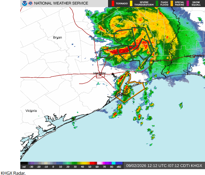
Flash Flood Warnings are in effect for East Central San Jacinto County, Southeastern Polk County, and Northeastern Liberty County.

A well defined center of circulation was evident in Tropical Depression Edouard.  Bands of showers and thunderstorms were revolving around the center of Edouard’s circulation.  The heaviest rain was falling in a band that was south of the center of Tropical Depression Edouard.  Moderate to heavy rain falling near the center of Edouard’s circulation.  Moderate to heavy rain was also falling south and east of the center of Tropical Depression Edouard.

Tropical Depression Edouard will move around the southwestern part of a high pressure system that is over the Southeast U.S.  The high pressure system will steer Edouard slowly toward the north-northwest during the next 24 hours.  On its anticipated track, Tropical Depression Edouard will continue to move farther inland over southeast Texas.

Tropical Storm Edouard will continue to drop heavy rain to parts of southeast Texas.  Heavy rain could cause flash floods in some locations.

A Flood Watch is in effect for parts of southeast Texas.

Tropical Storm Nestor Causes Severe Weather in Florida

Tropical Storm Nestor caused severe weather in Florida.  At 2:00 p.m. EDT on Saturday the center of Tropical Storm Nestor was located at latitude 29.7°N and longitude 85.1°W which put it about 5 miles (10 km) west of Apalachicola, Florida.  Nestor was moving toward the east-northeast at 23 m.p.h. (38 km/h).  The maximum sustained wind speed was 45 m.p.h. (75 km/h) and there were wind gusts to 60 m.p.h. (95 km/h).  The minimum surface pressure was 999 mb.

A Tropical Storm Watch was in effect for the portion of the coast from Ochlockonee River to Suwanee River, Florida.

Tropical Storm Nestor began a transition to an extratropical cyclone as it approached the coast of Florida.  Strong westerly winds in the middle latitudes created significant vertical wind shear.  In addition, the circulation around Nestor pulled cooler, drier air into the western and southern parts of the tropical storm.  The effects of the upper level westerly winds and cooler, drier air caused the strongest rising motion to occur in bands well to the east of the center of circulation.  The strongest thunderstorms occurred in bands southeast of the low level center.

The vertical wind shear was strong enough that rotation developed in some of the thunderstorms over the Florida Peninsula.  Several tornado warnings were issued on Friday night because radar indicated likely rotation.  There were reports of property damage due to possible tornadoes in Cape Coral in Lee County, near Winston in Polk County, in Plant City in Hillsborough County and in Seminole in Pinellas County.

The center of Tropical Storm Nestor officially made landfall on St. Vincent Island west of Apalachicola on Saturday afternoon.  Many of the stronger thunderstorms had moved east of Florida by Saturday afternoon.  There were still bands of showers and thunderstorms moving over the Florida Peninsula.  Flow diverging from a surface high pressure system centered over the northeastern U.S. was converging with the flow around the northern part of Tropical Storm Nestor.  The convergence was generating a large area of rising motion.  Showers and thunderstorms were occurring over northern Florida, southeastern Alabama, southern Georgia and parts of South Carolina.

Tropical Storm Nestor will move toward the northeast as an extratropical cyclone during the next several days.  On its anticipated track the center of Nestor will move across southern Georgia and near the coast of South Carolina and North Carolina.  The low pressure system will continue to drop rain over those areas.  There has been below normal rainfall over the southeastern U.S. in recent weeks.  So, the rain is unlikely to cause flooding in most places.