Tag Archives: Hawaii

Tropical Storm Calvin Forms South of Baja California

Tropical Storm Calvin formed over the Eastern North Pacific Ocean south of Baja California on Wednesday morning. At 5:00 a.m. EDT on Wednesday the center of Tropical Storm Calvin was located at latitude 10.4°N and longitude 110.6°W which put it about 725 miles (1170 km) south of the southern tip of Baja California. Calvin was moving toward the west at 16 m.p.h. (26 km/h). The maximum sustained wind speed was 45 m.p.h. (75 km/h) and there were wind gusts to 60 m.p.h. (105 km/h). The minimum surface pressure was 1004 mb.

A low pressure system over the Eastern North Pacific Ocean south of Baja California strengthened on Wednesday morning and the U.S. National Hurricane Center designated the system as Tropical Storm Calvin. The distribution of thunderstorms in Tropical Storm Calvin was asymmetrical. Most thunderstorms were occurring in bands in the western side of Calvin’s circulation. Bands in the eastern side of Calvin consisted primarily of showers and lower clouds. The inner end of a rainband wrapped around the southern side of the center of Tropical Storm Calvin. Storms near the center generated upper level divergence that pumped mass away from the tropical storm. The circulation around Calvin was small. Winds to tropical storm force extended out 45 miles (75 km) from the center of Calvin’s circulation.

Tropical Storm Calvin will move through an environment that will be mostly favorable for intensification during the next 36 hours. Calvin will move over water where the Sea Surface Temperatures are near 28˚C. It will move under the southwestern part of an upper level ridge over Mexico and the southwestern U.S. The upper level ridge will produce easterly winds that will blow toward the top of Calvin’s circulation. Those winds will cause vertical wind shear. The wind shear will inhibit intensification, but the shear will not be enough to prevent Calvin from getting stronger. Tropical Storm Calvin will intensify during the next 36 hours. Calvin could strengthen to a hurricane by Friday.

Tropical Storm Calvin will move around the southern part of a subtropical high pressure system over the Eastern North Pacific Ocean. The high pressure system will Calvin toward the west during the next few days. On its anticipated track, Tropical Storm Calvin will move farther away from Mexico. Calvin could move over the Central Pacific Ocean early next week.

Estelle Rapidly Intensifies to a Hurricane

Former Tropical Storm Estelle rapidly intensified to a hurricane over the Eastern North Pacific Ocean south of Manzanillo, Mexico on Saturday. At 11:00 p.m. EDT on Saturday the center of Hurricane Estelle was located at latitude 14.7°N and longitude 105.0°W which put it about 300 miles (485 km) south of Manzanillo, Mexico. Estelle was moving toward the west-northwest at 9 m.p.h. (15 km/h). The maximum sustained wind speed was 80 m.p.h. (130 km/h) and and there were wind gusts to 95 m.p.h. (150 km/h). The minimum surface pressure was 988 mb.

Former Tropical Storm Estelle rapidly intensified to a hurricane on Saturday. A circular eye was developing at the center of Hurricane Estelle’s circulation. The developing eye was surrounded by a ring of strong thunderstorms and the strongest winds were occurring in that ring of storms. Bands of showers and thunderstorms were revolving around the core of Hurricane Estelle. Storms near the core generated upper level divergence that pumped mass away from the hurricane in all directions. Winds to hurricane force extended out 15 miles (25 km) from the center of Estelle. Winds to tropical storm force extended out 70 miles (110 km) from the center of circulation.

Hurricane Estelle will move through an environment favorable for intensification during the next 36 hours. Estelle will move over water where the Sea Surface Temperatures are near 29˚C. It will move under an upper level ridge near the west coast of Mexico. The upper level winds are weak in the ridge and there will be little vertical wind shear. Hurricane Estelle will intensify during the next 36 hours. Estelle could continue to intensify rapidly and it could strengthen to a major hurricane.

Hurricane Estelle will move around the southern side of a high pressure system over Mexico. The high pressure system will steer Estelle toward the west-northwest during the next 36 hours. On its anticipated track Hurricane Estelle could be south of Baja California on Monday.

Elsewhere, Tropical Storm Darby weakened south of Hawaii. At 11:00 p.m. EDT on Saturday the center of Tropical Storm Darby was located at latitude 17.7°N and longitude 157.5°W which put it about 250 miles (400 km) south of Honolulu, Hawaii. Darby was moving toward the west at 22 m.p.h. (32 km/h). The maximum sustained wind speed was 40 m.p.h. (65 km/h) and and there were wind gusts to 50 m.p.h. (80 km/h). The minimum surface pressure was 1007 mb.

Tropical Storm Estelle Forms South of Mexico

Tropical Storm Estelle formed over the Eastern North Pacific Ocean south of Mexico on Friday night. At 11:00 p.m. EDT on Friday the center of Tropical Storm Estelle was located at latitude 13.2°N and longitude 102.0°W which put it about 290 miles (470 km) south-southwest of Acapulco, Mexico. Estelle was moving toward the northwest at 10 m.p.h. (16 km/h). The maximum sustained wind speed was 40 m.p.h. (65 km/h) and and there were wind gusts to 50 m.p.h. (80 km/h). The minimum surface pressure was 1006 mb.

An area of low pressure over the Eastern North Pacific Ocean south of Mexico strengthened on Friday night and the National Hurricane Center designated the system as Tropical Storm Estelle. The circulation around Estelle exhibited more organization. More thunderstorms developed near the center of Tropical Storm Estelle. Storms near the center of circulation generated upper level divergence that pumped mass away from the tropical storm. Bands of showers and thunderstorms were revolving around the center of Estelle’s circulation. Winds to tropical storm force extended out 45 miles (75 km) in the northeastern quadrant of Tropical Storm Estelle. The wind in the other parts of Estelle’s circulation were blowing at less than tropical storm force.

Tropical Storm Estelle will move through an environment favorable for intensification during the next 36 hours. Estelle will move over water where the Sea Surface Temperatures are near 28˚C. It will move under an upper level ridge near the west coast of Mexico. The upper level winds are weak in the ridge and there will be little vertical wind shear. Tropical Storm Estelle will intensify during the next 36 hours and it could strengthen to a hurricane.

Tropical Storm Estelle will move around the southern side of a high pressure system over Mexico. The high pressure system will steer Estelle toward the west-northwest during the next 36 hours. On its anticipated track Tropical Storm Estelle will move away from the west coast of Mexico.

Elsewhere, Tropical Storm Darby weakened east-southeast of Hawaii. At 11:00 p.m. EDT on Friday the center of Tropical Storm Darby was located at latitude 17.7°N and longitude 149.4°W which put it about 400 miles (640 km) east-southeast of Hilo, Hawaii. Darby was moving toward the west at 20 m.p.h. (32 km/h). The maximum sustained wind speed was 45 m.p.h. (75 km/h) and and there were wind gusts to 60 m.p.h. (95 km/h). The minimum surface pressure was 1006 mb.

Hurricane Darby Moves over the Central Pacific

Hurricane Darby moved over the Central Pacific Ocean on Thursday morning. At 11:00 a.m. EDT on Thursday the center of Hurricane Darby was located at latitude 16.6°N and longitude 140.9°W which put it about 955 miles (1540 km) east of Hilo, Hawaii. Darby was moving toward the west-northwest at 16 m.p.h. (26 km/h). The maximum sustained wind speed was 105 m.p.h. (165 km/h) and and there were wind gusts to 125 m.p.h. (200 km/h). The minimum surface pressure was 977 mb.

Hurricane Darby moved west of longitude 140°W west on Thursday morning which meant that it crossed from the Eastern North Pacific basin to the Central Pacific. A small eye persisted at the center of Darby’s circulation. The eye was surrounded by a ring of strong thunderstorms and the strongest winds were occurring in that ring of storms. Storms near the center of circulation generated upper level divergence that pumped mass away from the hurricane. The circulation around Hurricane Darby was small. Winds to hurricane force extended out 20 miles (30 km) from the center of Darby. Winds to tropical storm force extended out 45 miles (75 km) from the center of circulation.

Hurricane Darby will move into an environment unfavorable for intensification during the next 36 hours. Darby will move over water where the Sea Surface Temperatures are near 26˚C. An upper level trough located to the northwest of Hurricane Darby will produce southwesterly winds that will blow toward the top of Darby’s circulation. Those winds will cause the vertical wind shear to increase. More wind shear will cause Hurricane Darby to weaken. Since the circulation around Hurricane Darby is so small, the vertical wind shear could cause Darby to weaken quickly.

Hurricane Darby will move around the southern side of a high pressure system over the Central Pacific Ocean. The high pressure system will steer Darby toward the west during the next 36 hours. On its anticipated track Hurricane Darby could be southeast of Hawaii by Saturday. Darby is forecast to be much weaker by that time.

Major Hurricane Darby Churns Toward the Central Pacific

Major Hurricane Darby churned toward the Central Pacific Ocean on Tuesday. At 11:00 a.m. EDT on Tuesday the center of Hurricane Darby was located at latitude 14.7°N and longitude 129.7°W which put it about 1410 miles (2270 km) west-southwest of the southern tip of Baja California. Darby was moving toward the west at 16 m.p.h. (26 km/h). The maximum sustained wind speed was 125 m.p.h. (200 km/h) and and there were wind gusts to 150 m.p.h. (240 km/h). The minimum surface pressure was 959 mb.

Hurricane Darby had a small, but very symmetrical, circulation on Tuesday. A circular eye with a diameter of 12 miles (19 km) was at the center of Hurricane Darby. The eye was surrounded by a ring of strong thunderstorms and the strongest winds were occurring in that ring of storms. Several bands of showers and thunderstorms were revolving around the small core of Hurricane Darby. Storms near the core generated strong upper level divergence that pumped mass away from the hurricane. Winds to hurricane force extended out 15 miles (25 km) from the center of Darby’s circulation. Winds to tropical storm force extended out 50 miles (80 km) from the center of circulation.

Darby continued to exhibit the appearance of a small, annular hurricane. The Hurricane Intensity Index (HII) for Hurricane Darby was 23.6. The Hurricane Size Index (HSI) was 5.2 and the Hurricane Wind Intensity Size Index (HWISI) was 28.8.

Hurricane Darby will move into an environment unfavorable for intensification during the next 36 hours. Darby will move over water where the Sea Surface Temperatures are near 27˚C. It will move through a region where the upper level winds are weak and there will be little vertical wind shear. Hurricane Darby will move over cooler water during the next several days as it moves toward the west. Darby is likely to weaken gradually as it moves over the cooler water.

Hurricane Darby will move around the southern side of a high pressure system over the Eastern North Pacific Ocean. The high pressure system will steer Darby toward the west during the next 36 hours. On its anticipated track Hurricane Darby will cross into the Central Pacific Ocean on Wednesday night.

Darby Rapidly Intensifies to a Major Hurricane

Hurricane Darby rapidly intensified to a major hurricane over the Eastern North Pacific Ocean between Mexico and Hawaii on Monday morning. At 11:00 a.m. EDT on Monday the center of Hurricane Darby was located at latitude 14.6°N and longitude 123.4°W which put it about 1050 miles (1690 km) west-southwest of the southern tip of Baja California. Darby was moving toward the west at 15 m.p.h. (24 km/h). The maximum sustained wind speed was 125 m.p.h. (200 km/h) and and there were wind gusts to 150 m.p.h. (240 km/h). The minimum surface pressure was 965 mb.

Hurricane Darby continued to intensify rapidly on Monday morning. A circular eye with a diameter of 12 miles (19 km) was at the center of Hurricane Darby. The eye was surrounded by a ring of strong thunderstorms and the strongest winds were occurring in that ring of storms. Bands of showers and thunderstorms were revolving around the small core of Hurricane Darby. Storms near the core generated strong upper level divergence that pumped mass away from the hurricane. Winds to hurricane force extended out 15 miles (25 km) from the center of Darby’s circulation. Winds to tropical storm force extended out 60 miles (95 km) from the center of circulation.

The circulation around Hurricane Darby was small but very symmetrical. Darby looked like a small, annular hurricane. The Hurricane Intensity Index (HII) for Hurricane Darby was 23.6. The Hurricane Size Index (HSI) was 5.4 and the Hurricane Wind Intensity Size Index (HWISI) was 29.0.

Hurricane Darby will move through an environment favorable for intensification during the next 18 hours. Darby will move over water where the Sea Surface Temperatures are near 28˚C. It will move through a region where the upper level winds are weak and there will be little vertical wind shear. Hurricane Darby could continue to intensify during the 18 hours. The small size of the circulation around Hurricane Darby means that the intensity could continue to change rapidly if the environmental conditions change. If the inner end of a rainband wraps around the small core of Darby’s circulation, then an eyewall replacement cycle could cause Hurricane Darby to weaken.

Hurricane Darby will move around the southern side of a high pressure system over the Eastern North Pacific Ocean. The high pressure system will steer Darby toward the west during the next 24 hours. On its anticipated track Hurricane Darby will move farther away from Baja California. Darby will cross into the Central Pacific Ocean later this week.

Hurricane Darby Rapidly Intensifies to Cat. 2

Hurricane Darby rapidly intensified to Category 2 on the Saffir-Simpson Scale over the Eastern North Pacific Ocean between Mexico and Hawaii on Sunday night. At 6:00 a.m. EDT on Monday the center of Hurricane Darby was located at latitude 14.5°N and longitude 122.2°W which put it about 995 miles (1595 km) southwest of the southern tip of Baja California. Darby was moving toward the west at 16 m.p.h. (26 km/h). The maximum sustained wind speed was 105 m.p.h. (165 km/h) and and there were wind gusts to 125 m.p.h. (200 km/h). The minimum surface pressure was 975 mb.

Hurricane Darby rapidly intensified on Sunday night. A circular eye with a diameter of 12 miles (19 km) was evident on infrared and microwave satellite images. The eye was surrounded by a ring of strong thunderstorms and the strongest winds were occurring in that ring of storms. Bands of showers and thunderstorms were revolving around the small core of Darby’s circulation. Storms near the core generated upper level divergence that pumped mass away from the hurricane. Winds to hurricane force extended out 15 miles (25 km) from the center of Darby’s circulation. Winds to tropical storm force extended out 60 miles (95 km) from the center of circulation.

The circulation around Hurricane Darby was small but very symmetrical. Darby looked like a small, annular hurricane. The Hurricane Intensity Index (HII) for Hurricane Darby was 17.8. The Hurricane Size Index (HSI) was 4.5 and the Hurricane Wind Intensity Size Index (HWISI) was 22.3.

Hurricane Darby will move through an environment favorable for intensification during the next 24 hours. Darby will move over water where the Sea Surface Temperatures are near 28˚C. It will move through a region where the upper level winds are weak and there will be little vertical wind shear. Hurricane Darby is likely to continue to intensify during the 24 hours. Darby could strengthen to a major hurricane. The small size of the circulation around Hurricane Darby means that the intensity could continue to change rapidly if the environmental conditions change. If the inner end of a rainband wraps around the small core of Darby’s circulation, then an eyewall replacement cycle could cause fluctuations in intensity.

Hurricane Darby will move around the southern side of a high pressure system over the Eastern North Pacific Ocean. The high pressure system will steer Darby toward the west during the next 24 hours. On its anticipated track Hurricane Darby will move farther away from Baja California. Darby could cross into the Central Pacific Ocean later this week.

Possible Development East-Northeast of Hawaii

The National Hurricane Center (NHC) indicated that a low pressure system over the Eastern North Pacific Ocean east-northeast of Hawaii could develop into a subtropical or a tropical cyclone during the next 48 hours. The low pressure system is currently designated as Invest 90E. At 1:00 p.m. EST on Thursday the center of Invest 90E was located at latitude 21.8°N and longitude 136.1°W which put it about 1280 miles (2065 km) east-northeast of Hilo, Hawaii. It was moving toward the west-northwest at 12 m.p.h. (19 km/h). The maximum sustained wind speed was 45 m.p.h. (75 km/h) and there were wind gusts to 60 m.p.h. (95 km/h). The minimum surface pressure was 1006 mb.

The National Hurricane Center issued a Special Tropical Weather Outlook on Thursday afternoon which indicated that a low pressure system over the Eastern North Pacific Ocean had a 40% probability of development into a subtropical or a tropical cyclone during the next 48 hours. The low pressure system has been moving slowly toward the west between Baja California and Hawaii. The low pressure system currently has a hybrid structure. A well organized low level center of circulation was evident on visible satellite images. The low level center was located just to the east of a low pressure system in the middle and upper troposphere. The upper low was producing southerly winds that were blowing toward the top of the low level circulation. Those winds were causing moderate vertical wind shear and the wind shear was affecting the structure of the system. The strongest thunderstorms were occurring in bands north and east of the low level center of circulation. Bands south and west of the low level center consisted primarily of showers and lower clouds.

Invest 90E will move through an environment somewhat favorable for the formation of a subtropical or a tropical cyclone during the next 24 hours. The surface center of circulation will move over water where the Sea Surface Temperatures are near 24˚C. Since the upper low contains colder air, that water temperature is warm enough to support the development of a subtropical or a tropical cyclone. The low in the middle and upper troposphere will continue to cause moderate vertical wind shear. The wind shear will inhibit the development of a tropical cyclone. The current hybrid structure of Invest 90E and the marginally warm Sea Surface Temperatures would favor the development of a subtropical cyclone. However, if the strength of the upper level winds decreases, then a tropical cyclone could form.

Invest 90E will move south of a surface high pressure system over the Eastern North Pacific Ocean. The high pressure system will steer the low level center of circulation toward the west-northwest during the next 24 hours. On its anticipated track Invest 90E will move slowly toward the Central Pacific Ocean.

Tropical Storm Marty Develops South of Baja California

Tropical Storm Marty developed over the Eastern North Pacific Ocean south of Baja California on Monday morning. At 5:00 a.m. EDT on Monday the center of Tropical Storm Marty was located at latitude 20.0°N and longitude 111.0°W which put it about 210 miles (340 km) south-southwest of the southern tip of Baja California. Marty was moving toward the west at 15 m.p.h. (24 km/h). The maximum sustained wind speed was 40 m.p.h. (65 km/h) and there were wind gusts to 50 m.p.h. (80 km/h). The minimum surface pressure was 1000 mb.

The circulation of former Hurricane Grace developed into Tropical Storm Marty south of Baja California on Monday morning. Although the surface circulation of former Hurricane Grace dissipated when it moved across central Mexico during the weekend, the circulation in the middle and upper troposphere remained intact. New thunderstorms began to form when the middle and upper parts of the circulation moved over the Eastern North Pacific west of Mexico. Downdrafts in those thunderstorms transported momentum down to the surface and a low level circulation spun up. More thunderstorms formed near the low level center on Monday morning and the National Hurricane Center designated the system as Tropical Storm Marty.

The circulation around Tropical Storm Marty was well organized. Thunderstorms near the center of Marty were generating upper level divergence that was pumping mass away from the tropical storm. Bands of showers and thunderstorms were revolving around the center of Tropical Storm Marty. Winds to tropical storm force extended out 70 miles (110 km) from the center of Marty.

Tropical Storm Marty will move through an environment somewhat favorable for intensification during the next 24 hours. Marty will move over water where the Sea Surface Temperatures are near 27°C. It will move under the southern part of an upper level ridge centered near Baja California. The ridge will produce easterly winds that will blow toward the top of Marty’s circulation. Those winds will cause vertical wind shear. The wind shear will inhibit intensification, but it will not be strong enough to keep Tropical Storm Marty from getting stronger during the next 24 hours. Marty will move over cooler water on Tuesday and there will be less energy available to the tropical storm.

Tropical Storm Marty will move south of a subtropical high pressure system over the Eastern North Pacific Ocean. The high will steer Marty toward the west during the next several days. On its anticipated track Tropical Storm Marty will move farther away from Baja California.

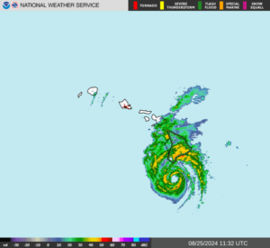
Elsewhere, the circulation of former Hurricane Linda was approaching Hawaii. At 2:00 a.m. EDT on Monday the center of former Hurricane Linda was located at latitude 21.0°N and longitude 154.8°W which put it about 115 miles (185 km) east of Wailuku,, Hawaii. It was moving toward the west at 12 m.p.h. (19 km/h). The maximum sustained wind speed was 45 m.p.h. (75 km/h) and there were wind gusts to 60 m.p.h. (95 km/h). The minimum surface pressure was 1006 mb. The circulation of former Hurricane Linda will bring gusty winds and locally heavy rain to parts of Hawaii during the next several days.

Hurricane Linda Strengthens Back to Cat. 2

Hurricane Linda strengthened back to Category 2 on the Saffir-Simpson Scale on Tuesday night. At 11:00 p.m. EDT on Tuesday the center of Hurricane Linda was located at latitude 17.9°N and longitude 129.5°W which put it about 1315 miles (2115 km) west-southwest of the southern tip of Baja California. Linda was moving toward the west at 12 m.p.h. (19 km/h). The maximum sustained wind speed was 105 m.p.h. (165 km/h) and there were wind gusts to 125 m.p.h. (200 km/h). The minimum surface pressure was 975 mb.

The circulation around Hurricane Linda continued to be very symmetrical. A large, circular was present at the center of Linda. The eye was surrounded by a ring of strong thunderstorms and the strongest winds were occurring in that ring of storms. Bands of showers and a few thunderstorms were revolving around the core of Hurricane Linda. Storms near the core generated upper level divergence that pumped mass away from the hurricane. Winds to hurricane force extended out 30 miles (50 km) from the center of Linda. Winds to tropical storm force extended out 90 miles (145 km) from the center of circulation.

Hurricane Linda will move through an environment that will become more unfavorable for a strong hurricane during the next several days. Linda will move over water where the Sea Surface Temperatures are near 25°C. It will move through a region where the upper level winds are weak and there will be little vertical wind shear. Cooler water will supply less energy for Hurricane Linda and it will weaken. However, symmetrical hurricanes tend to be nearly in balance with their environment. Since there will be little vertical wind shear, Hurricane Linda is likely to weaken very gradually at first. Linda will move into a region where there is more vertical wind shear later this week and it will weaken faster when that happens.

Hurricane Linda will move south of a subtropical high pressure system over the Eastern North Pacific Ocean during the next few days. The high pressure system will steer Linda toward the west-northwest. On its anticipated track Hurricane Linda will continue to move toward the Central Pacific. Linda could be northeast of Hawaii by the weekend.