Tag Archives: EP03

Tropical Storm Fabio Forms Southwest of Mexico

Tropical Storm Fabio formed over the Eastern North Pacific Ocean southwest of Mexico on Monday morning.  At 11:00 a.m. EDT on Monday the center of Tropical Storm Fabio was located at latitude 14.8°N and longitude 106.9°W which put the center about 335 miles (540 km) southwest of Manzanillo, Mexico.  Fabio was moving toward the northwest at 12 m.p.h. (19 km/h).  The maximum sustained wind speed was 40 m.p.h. (65 km/h) and there were wind gusts to 50 m.p.h. (80 km/h).  The minimum surface pressure was 1006 mb.

A low pressure system over the Eastern North Pacific Ocean southwest of Mexico strengthened on Monday morning and the U.S. National Hurricane Center designated the system as Tropical Storm Fabio.  More thunderstorms formed near the center of Fabio’s circulation.  However, the distribution of thunderstorms around Tropical Storm Fabio was asymmetrical.  Thunderstorms were occurring in bands in the southern and western parts of Fabio’s circulation.  Bands in the northern and eastern parts of Tropical Storm Fabio consisted primarily of showers and lower clouds.  Storms near the center of Fabio generated upper level divergence that pumped mass away to the west of the tropical storm.

Winds to tropical storm force extended out 70 miles in the southeastern quadrant of Tropical Storm Fabio.  The winds in the other parts of Fabio’s circulation were blowing at less than tropical storm force.

Tropical Storm Fabio will move through an environment somewhat favorable for intensification during the next 24 hours.  Fabio will move over water where the Sea Surface Temperatures are near 28°C.   It will move under the southern part of an upper level ridge over the Eastern North Pacific Ocean.  The ridge will produce easterly winds that will blow toward the top of Fabio’s circulation.  Those winds will cause some vertical wind shear, but the shear may not be enough to prevent intensification. The circulation around Fabio could interact with the circulation around Tropical Storm Emilia.  Tropical Storm Fabio could intensify during the next 24 hours.

Tropical Storm Fabio is currently being steered by the circulation around Tropical Storm Emilia.  Fabio is forecast to be steered toward the northwest during the next 24 hours.  On its anticipated track, Tropical Storm Fabio will move farther away from Mexico.  There is a chance that the circulations around Fabio and Tropical Storm Emilia could merge into a single circulation.

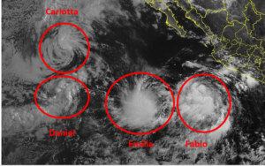
Elsewhere, Tropical Storms Carlotta, Daniel and Emilia were spinning over the Eastern North Pacific Ocean.

At 11:00 a.m. EDT on Monday the center of Tropical Storm Carlotta was located at latitude 20.4°N and longitude 127.2°W which put the center about 1125 miles (1805 km) west of the southern tip of Baja California.  Carlotta was moving toward the west at 9 m.p.h. (15 km/h).  The maximum sustained wind speed was 45 m.p.h. (75 km/h) and there were wind gusts to 60 m.p.h. (95 km/h).  The minimum surface pressure was 1001 mb.

At 11:00 a.m. EDT on Monday the center of Tropical Storm Daniel was located at latitude 15.6°N and longitude 127.7°W which put the center about 1265 miles (2035 km) west-southwest of the southern tip of Baja California.  Daniel was moving toward the northeast at 14 m.p.h. (22 km/h).  The maximum sustained wind speed was 40 m.p.h. (65 km/h) and there were wind gusts to 50 m.p.h. (80 km/h).  The minimum surface pressure was 1005 mb.

At 11:00 a.m. EDT on Monday the center of Tropical Storm Emilia was located at latitude 14.5°N and longitude 114.1°W which put the center about 640 miles (1035 km) west-southwest of the southern tip of Baja California.  Emilia was moving toward the south-southwest at 5 m.p.h. (8 km/h).  The maximum sustained wind speed was 45 m.p.h. (75 km/h) and there were wind gusts to 60 m.p.h. (120 km/h).  The minimum surface pressure was 1001 mb.


Carlotta Weakens to a Tropical Storm

Former Hurricane Carlotta weakened to a tropical storm over the Eastern North Pacific Ocean west of Baja California on Sunday.  At 5:00 p.m. EDT on Sunday the center of Tropical Storm Carlotta was located at latitude 19.9°N and longitude 125.0°W which put the center about 990 miles (1595 km) west of the southern tip of Baja California.  Carlotta was moving toward the west at 10 m.p.h. (16 km/h).  The maximum sustained wind speed was 60 m.p.h. (95 km/h) and there were wind gusts to 75 m.p.h. (120 km/h).  The minimum surface pressure was 998 mb.

Former Hurricane Carlotta weakened to a tropical storm on Sunday when it moved over cooler water in the Eastern North Pacific Ocean west of Baja California.  Many of the thunderstorms in Tropical Storm Carlotta weakened or dissipated on Sunday.  Even though the circulation around Carlotta weakened, it still appeared well organized in visible satellite images.  Numerous bands of showers, and low and middle clouds were revolving around the center of Carlotta’s circulation.  However, the showers near the center of Carlotta were too shallow to generate upper level divergence that could pump mass away from the tropical storm.  Thus, convergence of mass in the lower levels of the atmosphere caused the surface pressure to increase.

Tropical Storm Carlotta will move through an environment that will be unfavorable for intensification during the next 24 hours.  Carlotta will move over water where the Sea Surface Temperatures are near 25°C.  It will move near the axis of an upper level ridge over the Eastern North Pacific Ocean.  The upper level winds are weak near the axis of the ridge and there will be little vertical wind shear.  Tropical Storm Carlotta is likely to continue to weaken slowly as it moves over the cool water.

Tropical Storm Carlotta will move around the southern side of a high pressure system over the Eastern North Pacific Ocean.  The high pressure system will steer Carlotta toward the west during the next 24 hours.  On its anticipated track, Tropical Storm Carlotta will move farther away from Baja California.

Elsewhere over the Eastern North Pacific Ocean, Tropical Storm Daniel meandered west of Tropical Storm Carlotta and Tropical Depression Five-E formed south of Baja California.

At 5:00 p.m. EDT on Sunday the center of Tropical Storm Daniel was located at latitude 13.4°N and longitude 129.9°W which put the center about 1465 miles (2355 km) west-southwest of the southern tip of Baja California.  Daniel was moving toward the northeast at 8 m.p.h. (13 km/h).  The maximum sustained wind speed was 40 m.p.h. (65 km/h) and there were wind gusts to 50 m.p.h. (80 km/h).  The minimum surface pressure was 1006 mb.

At 5:00 p.m. EDT on Sunday the center of Tropical Depression Five-E was located at latitude 15.5°N and longitude 113.2°W which put the center about 555 miles (890 km) south-southwest of the southern tip of Baja California.  The tropical depression was moving toward the south at 2 m.p.h. (3 km/h).  The maximum sustained wind speed was 35 m.p.h. (55 km/h) and there were wind gusts to 45 m.p.h. (75 km/h).   The minimum surface pressure was 1007 mb.

Hurricane Carlotta Churns West

Hurricane Carlotta churned toward the west over the Eastern North Pacific Ocean on Saturday.  At 11:00 p.m. EDT on Saturday the center of Hurricane Carlotta was located at latitude 19.4°N and longitude 121.9°W which put the center about 810 miles (1300 km) west-southwest of the southern tip of Baja California.  Carlotta was moving toward the west-northwest at 10 m.p.h. (16 km/h).  The maximum sustained wind speed was 80 m.p.h. (130 km/h) and there were wind gusts to 95 m.p.h. (150 km/h).  The minimum surface pressure was 985 mb.

Hurricane Carlotta started to weaken slowly on Saturday night when it moved over cooler water.  Thunderstorms in Hurricane Carlotta did not rise as high into the atmosphere.  Even though Carlotta started to weaken, its circulation was well organized.  A small circular eye was still present at the center of Hurricane Carlotta.  The eye was surrounded by a ring of thunderstorms and the strongest winds were occurring in that ring of storms.  Bands of showers and thunderstorms were revolving around the core of Carlotta’s circulation.  Storms near the core of Carlotta still generated upper level divergence that pumped mass away from the hurricane.

The circulation around Hurricane Carlotta was small.  Winds to hurricane force extended out 25 miles (40 km) from the center of Carlotta’s circulation.  Winds to tropical storm force extended out 90 miles (145 km) from the center of Hurricane Carlotta.

Hurricane Carlotta will move through an environment that will be unfavorable for intensification during the next 24 hours.  Carlotta will move over water where the Sea Surface Temperatures are near 25°C.  It will move near the axis of an upper level ridge over the Eastern North Pacific Ocean.  The upper level winds are weak near the axis of the ridge and there will be little vertical wind shear.  Hurricane Carlotta is likely to continue to weaken slowly as it moves over even cooler water.

Hurricane Carlotta will move around the southern side of a high pressure system over the Eastern North Pacific Ocean.  The high pressure system will steer Carlotta toward the west during the next 24 hours.  On its anticipated track, Hurricane Carlotta will move farther away from Baja California.

Elsewhere over the Eastern North Pacific Ocean, Tropical Storm Daniel formed west of Hurricane Carlotta.  At 11:00 p.m. EDT on Saturday the center of Tropical Storm Daniel was located at latitude 12.3°N and longitude 130.5°W which put the center about 1540 miles (2475 km) west-southwest of the southern tip of Baja California.  Daniel was moving toward the north at 2 m.p.h. (3 km/h).  The maximum sustained wind speed was 40 m.p.h. (65 km/h) and there were wind gusts to 50 m.p.h. (80 km/h).  The minimum surface pressure was 1006 mb.

Carlotta Intensifies to a Hurricane

Former Tropical Storm Carlotta intensified to a hurricane over the Eastern North Pacific Ocean southwest of Baja California on Friday morning.  At 11:00 a.m. EDT on Friday the center of Hurricane Carlotta was located at latitude 18.6°N and longitude 115.2°W which put the center about 455 miles (730 km) southwest of the southern tip of Baja California.  Carlotta was moving toward the west-northwest at 14 m.p.h. (22 km/h).  The maximum sustained wind speed was 80 m.p.h. (130 km/h) and there were wind gusts to 100 m.p.h. (160 km/h).  The minimum surface pressure was 983 mb.

Former Tropical Storm Carlotta strengthened to a hurricane on Friday morning.  A small circular eye formed at the center of Carlotta’s circulation.  The eye was surrounded by a ring of thunderstorms and the strongest winds were occurring in that ring of storms.  Bands of showers and thunderstorms were revolving around the center of Hurricane Carlotta.  Storms near the center of Carlotta’s circulation generated upper level divergence that pumped mass away from the hurricane.

The circulation around Hurricane Carlotta was small.  Winds to hurricane force extended out 15 miles (25 km) from the center of Carlotta’s circulation.  Winds to tropical storm force extended out 80 miles (130 km) from the center of Hurricane Carlotta.

Hurricane Carlotta will move through an environment favorable for intensification during the next 24 hours.  Carlotta will move over water where the Sea Surface Temperatures are near 29°C.  It will move near the axis of an upper level ridge over the Eastern North Pacific Ocean.  The upper level winds are weak near the axis of the ridge and there will be little vertical wind shear.  Hurricane Carlotta will continue to intensify during the next 24 hours.

Hurricane Carlotta will move around the southern side of a high pressure system over the Southwest U.S. and the Eastern North Pacific Ocean.  The high pressure system will steer Carlotta toward the west-northwest during the next 24 hours.  On its anticipated track, Hurricane Carlotta will move farther away from Baja California.

Tropical Storm Carlotta Forms Southwest of Mexico

Tropical Storm Carlotta formed over the Eastern North Pacific Ocean southwest of Mexico on Wednesday afternoon.  At 5:00 p.m. EDT on Wednesday the center of Tropical Storm Carlotta was located at latitude 16.2°N and longitude 108.0°W which put the center about 310 miles (500 km) southwest of Manzanillo, Mexico.  Carlotta was moving toward the northwest at 12 m.p.h. (19 km/h).  The maximum sustained wind speed was 45 m.p.h. (75 km/h) and there were wind gusts to 60 m.p.h. (95 km/h).  The minimum surface pressure was 1003 mb.

A low pressure system over the Eastern North Pacific Ocean southwest of Mexico strengthened on Wednesday afternoon and the U.S. National Hurricane Center designated the system as Tropical Storm Carlotta.  The circulation around Tropical Storm Carlotta exhibited much more organization on Wednesday afternoon.  More thunderstorms formed near the center of Carlotta’s circulation.  Storms near the center of Carlotta began to generate upper level divergence that pumped mass away from the tropical storm.  Bands of showers and thunderstorms were revolving around the center of Tropical Storm Carlotta.

Winds to tropical storm force extended out 45 miles (75 km) from the center of Tropical Storm Carlotta.

Tropical Storm Carlotta will move through an environment favorable for intensification during the next 36 hours.  Carlotta will move over water where the Sea Surface Temperatures are near 29°C.  It will move under the axis of an upper level ridge over the Eastern North Pacific Ocean.  The upper level winds are weak near the axis of the ridge and there will be little vertical wind shear.  Tropical Storm Carlotta will intensify during the next 36 hours.  Carlotta could strengthen to a hurricane on Thursday.

Tropical Storm Carlotta will move around the southern side of a high pressure system over the Southwest U.S. and the Eastern North Pacific Ocean.  The high pressure system will steer Carlotta toward the west-northwest during the next 36 hours.  On its anticipated track, Tropical Storm Carlotta will remain far south of Baja California.

Tropical Storm Calvin Brings Gusty Winds and Rain to Hawaii

Tropical Storm Calvin brought gusty winds and rain to Hawaii on Wednesday. At 8:00 a.m. EDT on Wednesday the center of Tropical Storm Calvin was located at latitude 17.7°N and longitude 155.6°W which put it about 160 miles (260 km) south of Hilo, Hawaii. Calvin was moving toward the west at 20 m.p.h. (32 km/h). The maximum sustained wind speed was 50 m.p.h. (80 km/h) and there were wind gusts to 65 m.p.h. (105 km/h). The minimum surface pressure was 1003 mb.

A Tropical Storm Warning was in effect for Hawaii County.

After Tropical Storm Calvin strengthened late on Tuesday, it started to weaken again on Wednesday morning. An upper level trough northwest of Hawaii was producing southwesterly winds that were blowing toward the top of Calvin’s circulation. There were strong easterly winds in the lower levels of the atmosphere. The combination of southwesterly winds in the upper troposphere and easterly winds in the lower levels of the atmosphere caused strong vertical wind shear. The winds in the upper troposphere blew the top part of Tropical Storm Calvin toward the northeast. The strong easterly winds near the surface pushed the lower part of Calvin quickly toward the west.

The strong vertical wind shear caused Tropical Storm Calvin to weaken on Wednesday morning. The center of Calvin at the surface was passing south of the Big Island of Hawaii. Bands revolving around the center at the surface consisted primarily of showers and lower clouds. Thunderstorms were occurring in bands in the northern side of Tropical Storm Calvin where the wind was pushing air up the eastern slopes of the Hawaiian Islands. Winds to tropical storm force extended out 140 miles (220 km) in the northern side of Calvin’s circulation. Winds in the southern part of Calvin were blowing at less than tropical storm force.

Tropical Storm Calvin will move through an environment unfavorable for intensification during the next 24 hours. Calvin will move over water where the Sea Surface Temperatures are near 26˚C. However, the upper level trough northwest of Hawaii will continue to cause strong vertical wind shear. Tropical Storm Calvin will weaken to a tropical depression during the next 24 hours.

Tropical Storm Calvin will continue to produce gusty winds and locally heavy rain in Hawaii during the next 24 hours. The strongest wind gusts will occur at higher elevations. Calvin could cause isolated minor wind damage. Locally heavy rain could cause flooding in some locations. Flood Watches are in effect for the Big Island of Hawaii, Maui, Molokai, Lanai, and Kahoolawe.

Tropical Storm Calvin Speeds Toward Hawaii

Tropical Storm Calvin sped toward Hawaii on Tuesday. At 2:00 p.m. EDT on Tuesday the center of Tropical Storm Calvin was located at latitude 17.6°N and longitude 150.5°W which put it about 330 miles (640 km) east-southeast of Hilo, Hawaii. Calvin was moving toward the west at 22 m.p.h. (35 km/h). The maximum sustained wind speed was 45 m.p.h. (75 km/h) and there were wind gusts to 60 m.p.h. (95 km/h). The minimum surface pressure was 1002 mb.

A Tropical Storm Warning was in effect for Hawaii County.

Tropical Storm Calvin appeared to be getting stronger on Tuesday afternoon. More thunderstorms formed near the center of Calvin’s circulation. Storms near the center of circulation generated upper level divergence that pumped mass away from the tropical storm. Even though Tropical Storm Calvin appeared to be strengthening, the vertical structure of Calvin’s circulation seemed to tilt a little to the north in the middle and upper levels of the troposphere. Winds to tropical storm force extended out 105 miles (165 km) in the northern side of Tropical Storm Calvin. Winds to tropical storm force extended out 25 miles (40 km) in the southern side of Calvin.

Tropical Storm Calvin will move through an environment that will be somewhat favorable for intensification during the next 24 hours. Calvin will move over water where the Sea Surface Temperatures will increase to 26˚C. It will move through a region where the upper level winds are blowing from the south. Those winds are not very strong, but they will cause some vertical wind shear. Tropical Storm Calvin could strengthen during the next 24 hours in spite of the vertical wind shear.

Tropical Storm Calvin will move around the southern part of a subtropical high pressure system over the Eastern and Central Pacific Ocean. The high pressure system will steer Calvin toward the west during the next several days. On its anticipated track, Tropical Storm Calvin will move near the Big Island of Hawaii on Tuesday night. Calvin will bring gusty winds and locally heavy rain to Hawaii on Tuesday night and Wednesday. Flood Watches are in effect for the Big Island of Hawaii, Maui, Molokai, Lanai, and Kahoolawe.

Calvin Prompts Tropical Storm Watch for Hawaii

The potential impacts of Tropical Storm Calvin prompted the issuance of a Tropical Storm Watch for Hawaii. At 11:00 a.m. EDT on Monday the center of Tropical Storm Calvin was located at latitude 16.8°N and longitude 141.4°W which put it about 920 miles (1480 km) east of Hilo, Hawaii. Calvin was moving toward the west at 18 m.p.h. (30 km/h). The maximum sustained wind speed was 50 m.p.h. (80 km/h) and there were wind gusts to 65 m.p.h. (105 km/h). The minimum surface pressure was 1000 mb.

A Tropical Storm Watch was in effect for Hawaii County.

The U.S. Central Pacific Hurricane Center issued a Tropical Storm Watch for Hawaii County on Monday morning because of the potential effects of Tropical Storm Calvin. Former Hurricane Calvin weakened to a tropical storm on Sunday as it moved over cooler water east of Hawaii. Tropical Storm Calvin moved over water where the Sea Surface Temperatures were near 24˚C. Less energy was transported into the atmosphere from the cooler water and many of the thunderstorms in Calvin’s circulation dissipated. The bands revolving around the center of Tropical Storm Calvin consisted primarily of showers and lower clouds. Winds to tropical storm force extended out 105 miles (165 km) in the northern side of Calvin’s circulation. Winds to tropical storm force extended out 60 miles (95 km) in the southern side of the circulation.

Tropical Storm Calvin will move through an environment that will be mostly unfavorable for intensification during the next 24 hours. Calvin will move over water where the Sea Surface Temperatures are near 25˚C. It will move through a region where then upper level winds that are weak and there will be little vertical wind shear. Tropical Storm Calvin could continue to weaken during the next 24 hours because of the cooler water even though there will be little vertical wind shear. Calvin will move over slightly warmer water when it gets closer to Hawaii.

Tropical Storm Calvin will move around the southern part of a subtropical high pressure system over the Eastern and Central Pacific Ocean. The high pressure system will steer Calvin toward the west during the next several days. On its anticipated track, Tropical Storm Calvin will move near Hawaii on Tuesday night. Calvin could still be a tropical storm when it approaches Hawaii. Tropical Storm Calvin will bring gusty winds and locally heavy rain to Hawaii on Tuesday night and Wednesday.

Hurricane Calvin Churns Toward the Central Pacific

Hurricane Calvin churned toward the Central Pacific Ocean on Saturday. At 5:00 p.m. EDT on Saturday the center of Hurricane Calvin was located at latitude 15.0°N and longitude 130.4°W which put it about 1660 miles (2670 km) east of Hilo, Hawaii. Calvin was moving toward the west at 16 m.p.h. (26 km/h). The maximum sustained wind speed was 100 m.p.h. (160 km/h) and there were wind gusts to 120 m.p.h. (195 km/h). The minimum surface pressure was 975 mb.

Hurricane Calvin weakened on Saturday when it moved over cooler water east of Hawaii. Thunderstorms around the center of Calvin’s circulation did not rise as high into the atmosphere. The structure of Hurricane Calvin remained well organized even though the hurricane was weaker. A small circular eye was still present at the center of Calvin’s circulation. The eye was surrounded by a broken ring of thunderstorms and the strongest winds were occurring in that ring of storms. Bands of showers and thunderstorms were revolving around the core of Hurricane Calvin. Storms near the core still generated upper level divergence that pumped mass away from the hurricane.

The circulation around Hurricane Calvin was small. Winds to hurricane force extended out 25 miles (40 km) from the center of Calvin’s circulation. Winds to tropical storm force extended out 105 miles (165 km) from the center of circulation. The Hurricane Intensity Index (HII) for Hurricane Calvin was 16.5. The Hurricane Size Index (HSI) was 9.3 and the Hurricane Wind Intensity Size Index (HWISI) was 25.8.

Hurricane Calvin will move through an environment that will be unfavorable for intensification during the next 24 hours. Calvin will move over water where the Sea Surface Temperatures are near 25˚C. It will move through a region where then upper level winds that are weak and there will be little vertical wind shear. Hurricane Calvin will continue to weaken during the next 24 hours because of the cooler water even though there will be little vertical wind shear.

Hurricane Calvin will move around the southern part of a subtropical high pressure system over the Eastern and Central Pacific Ocean. The high pressure system will steer Calvin toward the west during the next several days. On its anticipated track, Hurricane Calvin will continue to move toward the Central Pacific Ocean. Calvin could approach Hawaii on Tuesday. Calvin could still be a tropical storm when it approaches Hawaii.

Calvin Rapidly Intensifies to a Major Hurricane

Hurricane Calvin rapidly intensified to a major hurricane over the Eastern North Pacific Ocean on Friday morning. At 11:00 a.m. EDT on Friday the center of Hurricane Calvin was located at latitude 13.6°N and longitude 123.2°W which put it about 1080 miles (1740 km) southwest of the southern tip of Baja California. Calvin was moving toward the west at 16 m.p.h. (26 km/h). The maximum sustained wind speed was 120 m.p.h. (195 km/h) and there were wind gusts to 140 m.p.h. (220 km/h). The minimum surface pressure was 960 mb.

Hurricane Calvin rapidly intensified to a major hurricane over the Eastern North Pacific Ocean southwest of Baja California on Friday morning. A small circular eye with a diameter of 17 miles (28 km) formed at the center of Calvin’s circulation. The eye was surrounded by a ring of thunderstorms and the strongest winds were occurring in that ring of storms. Bands of showers and thunderstorms were revolving around the core of Hurricane Calvin. Storms near the core generated upper level divergence that pumped mass away from the hurricane.

The size of the circulation around Hurricane Calvin increased as Calvin rapidly intensified. Winds to hurricane force extended out 30 miles (50 km) from the center of Calvin’s circulation. Winds to tropical storm force extended out 115 miles (185 km) from the center. The Hurricane Intensity Index (HII) for Hurricane Calvin was 22.1. The Hurricane Size Index (HSI) was 10.3 and the Hurricane Wind Intensity Size Index (HWISI) was 32.4.

Hurricane Calvin will move through an environment that will be favorable for intensification during the next 12 hours. Calvin will move over water where the Sea Surface Temperatures are near 28˚C. It will move through a region where then upper level winds that are weak and there will be little vertical wind shear. Hurricane Calvin could intensify during the next 12 hours. Calvin will move over cooler water on Saturday. Hurricane Calvin is likely to weaken when it moves over the cooler water.

Hurricane Calvin will move around the southern part of a subtropical high pressure system over the Eastern North Pacific Ocean. The high pressure system will steer Calvin toward the west during the next several days. On its anticipated track, Hurricane Calvin will move toward the Central Pacific Ocean. Calvin could approach Hawaii on Tuesday. Calvin could still be a tropical storm when it approaches Hawaii.