Tag Archives: EP06

Hurricane Flossie Weakens Rapidly

Hurricane Flossie weakened rapidly on Wednesday evening as it moved over the Eastern North Pacific Ocean south of Baja California.  At 11:00 p.m. EDT on Wednesday the center of Hurricane Flossie was located at latitude 19.8°N and longitude 110.2°W which put the center about 215 miles (345 km) south of Cabo San Lucas, Mexico.  Flossie was moving toward the northwest at 8 m.p.h. (13 km/h).  The maximum sustained wind speed was 75 m.p.h. (120 km/h) and there were wind gusts to 90 m.p.h. (145 km/h).  The minimum surface pressure was 986 mb.

Hurricane Flossie was weakening rapidly on Wednesday evening as it moved over cooler water south of Baja California.  Many of the thunderstorms in Flossie’s circulation were dissipating,  The bands revolving around the center of Hurricane Flossie consisted primarily of showers and lower clouds.  The dissipation of the thunderstorms in Flossie greatly reduced the upper level divergence.  Much less mass was being pumped away from Hurricane Flossie.  The continued convergence of mass in the lower levels of Flossie’s circulation caused the surface pressure to increase quickly.

The circulation around Hurricane Flossie was small.  Winds to hurricane force extended out 25 miles (40 km) from the center of Flossie’s circulation.  Winds to tropical storm force extended out 70 miles (110 km) from the center of Hurricane Flossie.

Hurricane Flossie will move through an environment that will be unfavorable for intensification during the next 24 hours.  Flossie will move over water where where the Sea Surface Temperatures are near 23°C.  It will move under the middle of an upper level ridge over Mexico and the adjacent part of the Eastern North Pacific Ocean.  The upper level winds are weak near the middle of the ridge and there will be little vertical wind shear.  Even though there will be little vertical wind shear, the cooler water south of Baja California will cause Hurricane Flossie to continue to weaken on Thursday.

Hurricane Flossie will move around the southwestern part of a high pressure system over Mexico.  The high pressure system will steer the Flossie toward the northwest during the next 24 hours.  On its anticipated track, Hurricane Flossie will remain south of Baja California.

Flossie Intensifies to a Major Hurricane

Hurricane Flossie intensified to a major hurricane over the Eastern North Pacific Ocean southwest of Mexico on Tuesday evening.  At 11:00 p.m. EDT on Tuesday the center of Hurricane Flossie was located at latitude 18.2°N and longitude 107.4°W which put the center about 365 miles (585 km) south-southeast of Cabo San Lucas, Mexico.   Flossie was moving toward the west-northwest at 9 m.p.h. (15 km/h).  The maximum sustained wind speed was 115 m.p.h. (185 km/h) and there were wind gusts to 140 m.p.h. (220 km/h).   The minimum surface pressure was 962 mb.

A Tropical Storm Warning is in effect for the portion of the coast from Punta San Telmo to Playa Perula, Mexico.

Hurricane Flossie continued to intensify on Tuesday evening.  A circular eye was at the center of Flossie’s circulation.  The eye was surrounded by a ring of thunderstorms and the strongest winds were occurring in that ring of storms.  Bands of showers and thunderstorms were revolving around the core of Hurricane Flossie.  Storms near the center of Flossie generated upper level divergence that pumped mass away from the hurricane in all directions.  The removal of mass caused the surface pressure to decrease.

The circulation around Hurricane Flossie was relatively small.  Winds to hurricane force extended out 25 miles (40 km) from the center of Flossie’s circulation.  Winds to tropical storm force extended out 90 miles (145 km) from the center of Hurricane Flossie.

The Hurricane Intensity Index (HII) for Hurricane Flossie is 20.6.  The Hurricane Size Index (HSI) is 8.3 and the Hurricane Wind Intensity Size Index (HWISI) is 28.9.  Hurricane Flossie is similar in size and intensity to Hurricane Zeta when Zeta hit Louisiana in 2020.

Hurricane Flossie will move through an environment that will be somewhat favorable for intensification during the next 12 hours.  Flossie will move over water where where the Sea Surface Temperatures are near 27°C.  It will move under the middle of an upper level ridge over Mexico and the adjacent part of the Eastern North Pacific Ocean.  The upper level winds are weak near the middle of the ridge and there will be little vertical wind shear.  Hurricane Flossie could continue to intensify during the next 12 hours.  Flossie will move over cooler water later in Wednesday.  Hurricane Flossie will start to weaken when it moves over cooler water.

Hurricane Flossie will move around the southwestern part of a high pressure system over Mexico.  The high pressure system will steer the Flossie toward the northwest during the next 24 hours.  On its anticipated track, Hurricane Flossie will start to move farther away from the coast of southwestern Mexico.  Flossie will move south of Baja California on Wednesday night.

Bands in the northeastern side of Hurricane Flossie will bring gusty winds and locally heavy rain to parts of the coast of southwestern Mexico.  The heaviest rain will fall in parts of Michoacan, Colima, and Jalisco.  Heavy rain could cause flash floods in some locations.

Hurricane Flossie Strengthens to Cat. 2

Hurricane Flossie strengthened to Category 2 on the Saffir-Simpson Scale as it moved over the Eastern North Pacific Ocean southwest of Mexico on Tuesday morning.  At 11:00 a.m. EDT on Tuesday the center of Hurricane Flossie was located at latitude 17.4°N and longitude 105.9°W which put the center about 150 miles (240 km) southwest of Manzanillo, Mexico.  Flossie was moving toward the northwest at 10 m.p.h. (16 km/h).  The maximum sustained wind speed was 100 m.p.h. (160 km/h) and there were wind gusts to 120 m.p.h. (195 km/h).  The minimum surface pressure was 974 mb.

A Tropical Storm Warning is in effect for the portion of the coast from Punta San Telmo to Playa Perula, Mexico.

A Tropical Storm Watch is in effect for the portion of the coast from Playa Perula to Cabo Corrientes, Mexico.  A Tropical Storm Watch is in effect for the portion of the coast from Punta San Telmo to Zihuatanejo, Mexico.

The inner end of a rainband wrapped around the center of Hurricane Flossie on Tuesday morning.  A circular eye was visible at the center of Flossie’s circulation on satellite images.  The eye was surrounded by a ring of thunderstorms and the strongest winds were occurring in that ring of storms.  Bands of showers and thunderstorms were revolving around the core of Hurricane Flossie.  Storms near the center of Flossie generated upper level divergence that pumped mass away from the hurricane in all directions.  The removal of mass caused the surface pressure to decrease.

The area of hurricane force winds speeds in Hurricane Flossie increased on Tuesday.  Winds to hurricane force extended out 25 miles (40 km) from the center of Flossie’s circulation.  Winds to tropical storm force extended out 90 miles (145 km) from the center of Hurricane Flossie.

Hurricane Flossie will move through an environment very favorable for intensification during the next 24 hours.  Flossie will move over water where where the Sea Surface Temperatures are near 29°C.  It will move under the middle of an upper level ridge over Mexico and the adjacent part of the Eastern North Pacific Ocean.  The upper level winds are weak near the middle of the ridge and there will be little vertical wind shear.  Hurricane Flossie will intensify during the next 24 hours.  Flossie could intensify rapidly at times.  Hurricane Flossie is likely to strengthen to a major hurricane by Wednesday.

Hurricane Flossie will move around the southwestern part of a high pressure system over Mexico.  The high pressure system will steer the Flossie toward the northwest during the next 24 hours.  On its anticipated track, Hurricane Flossie will move parallel to the coast of southwestern Mexico.  Flossie is likely to move south of Baja California on Wednesday night.

Bands in the northeastern side of Hurricane Flossie will bring gusty winds and locally heavy rain to parts of the coast of southwestern Mexico.  The heaviest rain will fall in parts of Guerrero, Michoacan, Colima, and Jalisco.  Heavy rain could cause flash floods in some locations.

Flossie Intensifies to a Hurricane South of Mexico

Former Tropical Storm Flossie intensified to a hurricane over the Eastern North Pacific Ocean south of Mexico on Monday night.  At 11:00 p.m. EDT on Monday the center of Hurricane Flossie was located at latitude 16.5°N and longitude 104.3°W which put the center about 175 miles (280 km) south of Manzanillo, Mexico.  Flossie was moving toward the west-northwest at 10 m.p.h. (16 km/h).  The maximum sustained wind speed was 75 m.p.h. (120 km/h) and there were wind gusts to 90 m.p.h. (145 km/h).  The minimum surface pressure was 988 mb.

A Tropical Storm Warning is in effect for the portion of the coast from Punta San Telmo to Playa Perula, Mexico.

A Tropical Storm Watch is in effect for the portion of the coast from Playa Perula to Cabo Corrientes, Mexico.  A Tropical Storm Watch is in effect for the portion of the coast from Punta San Telmo to Zihuatanejo, Mexico.

Former Tropical Storm Flossie intensified steadily on Monday and the U.S. National Hurricane Center upgraded Flossie to a hurricane on Monday night.

The inner end of a rainband wrapped around the northern side of the center of Hurricane Flossie.  An eye appeared to be forming at the center of Flossie’s circulation.  The strongest winds were occurring in the inner end of the rainband that wrapped around the center of Hurricane Flossie.  Other bands of showers and thunderstorms were revolving around the center of Flossie’s circulation.  Storms near the center of Flossie generated upper level divergence that pumped mass away from the hurricane in all directions. The removal of mass caused the surface pressure to decrease.

The distribution of winds speeds in Hurricane Flossie became more symmetrical on Monday.  Winds to hurricane force extended out 15 miles (25 km) from the center of Flossie’s circulation.  Winds to tropical storm force extended out 115 miles (185 km) from the center of Hurricane Flossie.

Hurricane Flossie will move through an environment very favorable for intensification during the next 24 hours.  Flossie will move over water where where the Sea Surface Temperatures are near 30°C.  It will move under the middle of an upper level ridge over southern Mexico and the adjacent part of the Eastern North Pacific Ocean.  The upper level winds are weak near the middle of the ridge and there will be little vertical wind shear.  Hurricane Flossie will intensify during the next 24 hours.  Flossie could intensify rapidly at times.  Hurricane Flossie could strengthen to a major hurricane.

Hurricane Flossie will move around the southwestern part of a high pressure system over Mexico.  The high pressure system will steer the Flossie toward the northwest during the next 24 hours.  On its anticipated track, Hurricane Flossie will move parallel to the coast of southwestern Mexico.

Bands in the northern side of Hurricane Flossie will bring gusty winds and locally heavy rain to parts of the coast of southwestern Mexico.   The heaviest rain will fall in parts of Guerrero, Michoacan, Colima, and Jalisco.  Heavy rain could cause flash floods in some locations.

Depression Strengthens to Tropical Storm Flossie

Former Tropical Depression Six-E strengthened to Tropical Storm Flossie over the Eastern North Pacific Ocean south of Mexico on Sunday.  At 11:00 a.m. EDT on Sunday the center of Tropical Storm Flossie was located at latitude 13.4°N and longitude 99.9°W which put the center about 240 miles (390 km) south of Acapulco, Mexico.   Flossie was moving toward the west at 9 m.p.h. (15 km/h).  The maximum sustained wind speed was 40 m.p.h. (65 km/h) and there were wind gusts to 50 m.p.h. (80 km/h).  The minimum surface pressure was 1005 mb.

A Tropical Storm Watch is in effect for the portion of the coast from Zihuatanejo to Cabo Corrientes, Mexico.

Former Tropical Depression Six-E continued to strengthen on Sunday.  The U.S. National Hurricane Center upgraded former Tropical Depression Six-E to Tropical Storm Flossie.

The circulation around Tropical Storm Flossie continue to get more organized on Sunday.  More thunderstorms developed near the center of Flossie’s circulation.  More thunderstorms also formed in bands revolving around the center of Tropical Storm Flossie.  Storms near the center of Flossie generated upper level divergence that pumped mass away from the tropical depression.  The removal of mass caused the surface pressure to decrease.

Tropical Storm Flossie will move through an environment very favorable for intensification during the next 24 hours.  Flossie will move over water where where the Sea Surface Temperatures are near 30°C.  It will move under the middle of an upper level ridge over southeastern Mexico and the adjacent part of the Eastern North Pacific Ocean.  The upper level winds are weak near the middle of the ridge and there will be little vertical wind shear.  Tropical Storm Flossie will intensify during the next 24 hours.  Flossie could intensify rapidly at times.  Tropical Storm Flossie is likely to strengthen to a hurricane on Monday.

Tropical Storm Flossie will move around the southwestern part of a high pressure system over southern Mexico.  The high pressure system will steer the Flossie toward the northwest during the next 24 hours.  On its anticipated track, Tropical Storm Flossie will move a little closer to the coast of southern Mexico.

Bands in the northern side of Tropical Storm Flossie will bring gusty winds and locally heavy rain to parts of the coast of southern Mexico.  Heavy rains could cause flash floods in some locations.

Tropical Depression Six-E Forms South of Mexico

Tropical Depression Six-E formed over the Eastern North Pacific Ocean south of Mexico early on Sunday.  At 5:00 a.m. EDT on Sunday the center of Tropical Depression Six-E was located at latitude 13.0°N and longitude 99.5°W which put the center about 270 miles (435 km) south of Acapulco, Mexico.  The tropical depression was moving toward the west at 12 m.p.h. (19 km/h).  The maximum sustained wind speed was 30 m.p.h. (50 km/h) and there were wind gusts to 40 m.p.h. (65 km/h).  The minimum surface pressure was 1008 mb.

A Tropical Storm Watch is in effect for the portion of the coast from Zihuatanejo to Manzanillo, Mexico.

A low pressure system over the Eastern North Pacific Ocean south of Mexico strengthened early on Sunday and the U.S. National Hurricane Center designated the system as Tropical Depression Six-E.

The circulation around Tropical Depression Six-E exhibited much more organization on Sunday morning.  More thunderstorms developed near the center of the depression’s circulation.  More thunderstorms also formed in bands revolving around the center of Tropical Depression Six-E.  Storms near the center of circulation started to generate upper level divergence that pumped mass away from the tropical depression.  The removal of mass caused the surface pressure to start to decrease.

Tropical Depression Six-E will move through an environment very favorable for intensification during the next 24 hours.  The tropical depression will move over water where where the Sea Surface Temperatures are near 30°C.  It will move under the middle of an upper level ridge over southeastern Mexico and the adjacent part of the Eastern North Pacific Ocean.  The upper level winds are weak near the middle of the ridge and there will be little vertical wind shear.  Tropical Depression Six-E will intensify during the next 24 hours.  It is likely to strengthen to a tropical storm by Monday.  The tropical depression could intensify to a hurricane early next week.

Tropical Depression Six-E will move around the southwestern part of a high pressure system over southern Mexico.  The high pressure system will steer the tropical depression toward the west-northwest during the next 24 hours.  On its anticipated track, Tropical Depression Six-E will move a little closer to the coast of southern Mexico.

Bands on the northern side of Tropical Depression Six-E will bring gusty winds and locally heavy rain to parts of the coast of southern Mexico.  Heavy rains could cause flash floods in some locations.

Tropical Storm Emilia Absorbs Fabio

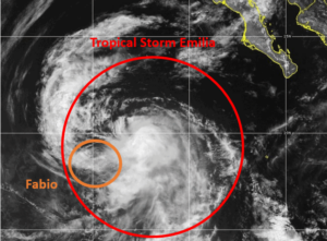
The circulation around Tropical Storm Emilia absorbed the circulation of former Tropical Storm Fabio on Wednesday afternoon.

At 5:00 p.m. EDT on Wednesday the center of Tropical Storm Emilia was located at latitude 19.1°N and longitude 117.7°W which put the center about 565 miles (910 km) west-southwest of the southern tip of Baja California.  Emilia was moving toward the northwest at 18 m.p.h. (30 km/h).  The maximum sustained wind speed was 65 m.p.h. (105 km/h) and there were wind gusts to 80 m.p.h. (130 km/h).  The minimum surface pressure was 990 mb.

At 5:00 p.m. EDT on Wednesday the center of former Tropical Storm Fabio was located at latitude 18.4°N and longitude 120.2°W which put the center about 735 miles (1180 km) west-southwest of the southern tip of Baja California.  Fabio was moving toward the southwest at 16 m.p.h. (26 km/h).  The maximum sustained wind speed was 40 m.p.h. (65 km/h) and there were wind gusts to 50 m.p.h. (80 km/h).  The minimum surface pressure was 1004 mb.

The larger circulation around Tropical Storm Emilia absorbed the smaller circulation around Tropical Storm Fabio on Wednesday.

The absorption of Fabio’s circulation did disrupt the circulation around Tropical Storm Emilia, especially on the western side of its circulation.  Bands in the northern and western parts of Tropical Storm Emilia consisted primarily of showers and lower clouds.  Thunderstorms were still occurring in bands in the southern and eastern parts of Emilia’s circulation.  The interactions of the two circulations also inhibited upper level divergence to the north and west of Tropical Storm Emilia.

Winds to tropical storm force extended out 115 miles (185 km) from the center of Tropical Storm Emilia.

Tropical Storm Emilia will move into an environment that will become unfavorable for intensification during the next 24 hours.  Emilia will move move over water where the Sea Surface Temperatures are near 25°C.  It will move under the axis of an upper level ridge over the Eastern North Pacific Ocean.  The upper level winds are weak near the axis of the ridge and there will be little vertical wind shear.  Tropical Storm Emilia will weaken when it moves over cooler water on Thursday.

Tropical Storm Emilia will move around the southern part of a subtropical high pressure system over the Eastern North Pacific Ocean.  The high pressure system will steer Emilia toward the west-northwest during the next 24 hours.  On its anticipated track, Tropical Storm Emilia will move farther away from Baja California.

Tropical Storms Emilia and Fabio Interact

The circulations around Tropical Storms Emilia and Fabio were interacting on Tuesday afternoon.

At 5:00 p.m. EDT on Tuesday the center of Tropical Storm Emilia was located at latitude 14.4°N and longitude 115.3°W which put the center about 685 miles (1110 km) south-southwest of the southern tip of Baja California.  Emilia was moving toward the northwest at 3 m.p.h. (5 km/h).  The maximum sustained wind speed was 65 m.p.h. (105 km/h) and there were wind gusts to 80 m.p.h. (130 km/h).  The minimum surface pressure was 992 mb.

At 5:00 p.m. EDT on Tuesday the center of Tropical Storm Fabio was located at latitude 19.2°N and longitude 113.9°W which put the center about 625 miles (1010 km) west of Manzanillo, Mexico.  Fabio was moving toward the west-northwest at 21 m.p.h. (33 km/h).  The maximum sustained wind speed was 60 m.p.h. (95 km/h) and there were wind gusts to 75 m.p.h. (120 km/h).  The minimum surface pressure was 997 mb.

The circulations around Tropical Storm Emilia and Fabio were interacting on Tuesday afternoon.  Winds blowing around the southern side of Fabio’s circulation were interacting with winds that were blowing around the northern side of Tropical Storm Emilia.  The interactions were occurring in both the upper and lower troposphere.  The interactions were affecting the structures of both tropical storms.

Tropical Storm Emilia appeared to be the larger and more powerful of the two tropical storms.  Even so, the flow around the southern side of Fabio was having an effect on Emilia’s structure.  Most of the thunderstorms in Tropical Storm Emilia were occurring in bands in the southern half of Emilia’s circulation.  Bands in the northern side of Emilia consisted primarily of showers and low clouds.  Outflow from Tropical Storm Fabio was inhibiting upper level divergence to the north of Tropical Storm Emilia.

The interactions between the two tropical storms was also affecting the distribution of wind speeds in Tropical Storm Emilia.  Winds to tropical storm force extended out 140 miles (220 km) in the southern half of Emilia’s circulation.  Winds to tropical storm force only extended out 70 miles (110 km) in the northern side of Emilia.

The interaction with Tropical Storm Emilia appeared to be contributing to the start of a weakening trend in Tropical Storm Fabio.  The interaction with Emilia was also affecting the structure of Tropical Storm Fabio.  Most of the thunderstorms were occurring in bands in the eastern side of Fabio’s circulation.  Bands in the western part of Tropical Storm Fabio consisted primarily of showers and lower clouds.  Outflow from Tropical Storm Emilia was inhibiting upper level divergence to the south and west of Tropical Storm Fabio,

The interactions between the two tropical storms was also affecting the distribution of wind speeds in Tropical Storm Fabio.  Winds to tropical storm force extended out 100 miles (160 km) in the eastern side of Fabio’s circulation.  Winds to tropical storm force only extended out 35 miles (55 km) in the eastern half of Fabio.

It is possible that the larger circulation around Tropical Storm Emilia could absorb the smaller circulation of Tropical Storm Fabio.  The circulation around Fabio will continue to disrupt part of the circulation in the northern part of Tropical Storm Emilia.  Emilia may not intensify much during the interactions between the two storms.

Tropical Storm Emilia will move through an environment that is otherwise favorable for intensification during the next 24 hours.  Emilia will move move over water where the Sea Surface Temperatures are near 28°C.   It will move under an axis of an upper level ridge over the Eastern North Pacific Ocean.  The upper level winds are weak near the axis of the ridge.  There will be little vertical wind shear except for the shear caused by the outflow from Tropical Storm Fabio.  Tropical Storm Emilia is likely to intensify during the next 24 hours.  Emilia could strengthen to a hurricane.

Tropical Storm Emilia will move around the southern side of a high pressure system over the Eastern North Pacific Ocean.  The interaction with Tropical Storm Fabio is likely to pull Emilia toward the northwest during the next 24 hours.  On its anticipated track, Tropical Storm Emilia will move farther away from Baja California.  Emilia is likely to be steered toward the west-northwest by the high pressure system after it absorbs Tropical Storm Fabio.

Tropical Storm Fabio Forms Southwest of Mexico

Tropical Storm Fabio formed over the Eastern North Pacific Ocean southwest of Mexico on Monday morning.  At 11:00 a.m. EDT on Monday the center of Tropical Storm Fabio was located at latitude 14.8°N and longitude 106.9°W which put the center about 335 miles (540 km) southwest of Manzanillo, Mexico.  Fabio was moving toward the northwest at 12 m.p.h. (19 km/h).  The maximum sustained wind speed was 40 m.p.h. (65 km/h) and there were wind gusts to 50 m.p.h. (80 km/h).  The minimum surface pressure was 1006 mb.

A low pressure system over the Eastern North Pacific Ocean southwest of Mexico strengthened on Monday morning and the U.S. National Hurricane Center designated the system as Tropical Storm Fabio.  More thunderstorms formed near the center of Fabio’s circulation.  However, the distribution of thunderstorms around Tropical Storm Fabio was asymmetrical.  Thunderstorms were occurring in bands in the southern and western parts of Fabio’s circulation.  Bands in the northern and eastern parts of Tropical Storm Fabio consisted primarily of showers and lower clouds.  Storms near the center of Fabio generated upper level divergence that pumped mass away to the west of the tropical storm.

Winds to tropical storm force extended out 70 miles in the southeastern quadrant of Tropical Storm Fabio.  The winds in the other parts of Fabio’s circulation were blowing at less than tropical storm force.

Tropical Storm Fabio will move through an environment somewhat favorable for intensification during the next 24 hours.  Fabio will move over water where the Sea Surface Temperatures are near 28°C.   It will move under the southern part of an upper level ridge over the Eastern North Pacific Ocean.  The ridge will produce easterly winds that will blow toward the top of Fabio’s circulation.  Those winds will cause some vertical wind shear, but the shear may not be enough to prevent intensification. The circulation around Fabio could interact with the circulation around Tropical Storm Emilia.  Tropical Storm Fabio could intensify during the next 24 hours.

Tropical Storm Fabio is currently being steered by the circulation around Tropical Storm Emilia.  Fabio is forecast to be steered toward the northwest during the next 24 hours.  On its anticipated track, Tropical Storm Fabio will move farther away from Mexico.  There is a chance that the circulations around Fabio and Tropical Storm Emilia could merge into a single circulation.

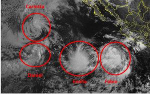
Elsewhere, Tropical Storms Carlotta, Daniel and Emilia were spinning over the Eastern North Pacific Ocean.

At 11:00 a.m. EDT on Monday the center of Tropical Storm Carlotta was located at latitude 20.4°N and longitude 127.2°W which put the center about 1125 miles (1805 km) west of the southern tip of Baja California.  Carlotta was moving toward the west at 9 m.p.h. (15 km/h).  The maximum sustained wind speed was 45 m.p.h. (75 km/h) and there were wind gusts to 60 m.p.h. (95 km/h).  The minimum surface pressure was 1001 mb.

At 11:00 a.m. EDT on Monday the center of Tropical Storm Daniel was located at latitude 15.6°N and longitude 127.7°W which put the center about 1265 miles (2035 km) west-southwest of the southern tip of Baja California.  Daniel was moving toward the northeast at 14 m.p.h. (22 km/h).  The maximum sustained wind speed was 40 m.p.h. (65 km/h) and there were wind gusts to 50 m.p.h. (80 km/h).  The minimum surface pressure was 1005 mb.

At 11:00 a.m. EDT on Monday the center of Tropical Storm Emilia was located at latitude 14.5°N and longitude 114.1°W which put the center about 640 miles (1035 km) west-southwest of the southern tip of Baja California.  Emilia was moving toward the south-southwest at 5 m.p.h. (8 km/h).  The maximum sustained wind speed was 45 m.p.h. (75 km/h) and there were wind gusts to 60 m.p.h. (120 km/h).  The minimum surface pressure was 1001 mb.


Hurricane Dora Moves Southeast of Hawaii

Hurricane Dora moved southeast of Hawaii on Monday. At 11:00 p.m. EDT on Monday the center of Hurricane Dora was located at latitude 12.0°N and longitude 152.3°W which put it about 565 miles (905 km) south-southeast of Hilo, Hawaii. Dora was moving toward the west at 23 m.p.h. (37 km/h). The maximum sustained wind speed was 130 m.p.h. (210 km/h) and there were wind gusts to 155 m.p.h. (250 km/h). The minimum surface pressure was 953 mb.

Hurricane Dora weakened slightly on Monday. The structure of Dora continued to be very symmetrical. An eye with a diameter of 12 miles (19 km) was at the center of Hurricane Dora. The eye was surrounded by a ring of thunderstorms and the strongest winds were occurring in that ring of storms. Bands of showers and thunderstorms were revolving around the core of Dora’s circulation. Storms near the core generated upper level divergence that pumped mass away from the hurricane.

The size of the circulation around Hurricane Dora increased a little on Monday. Winds to hurricane force extended out 30 miles (50 km) from the center of Dora’s circulation. Winds to tropical storm force extended out 115 miles (185 km) from the center of circulation. The Hurricane Intensity Index (HII) was 25.1. The Hurricane Size Index (HSI) was 9.9 and the Hurricane Wind Intensity Size Index (HWISI) was 35.0.

Hurricane Dora will move through an environment that will be favorable for a major hurricane during the next 24 hours. Dora will move over water where the Sea Surface Temperatures are near 26.5°C. It will move through a region where the upper level winds are weak and there will be little vertical wind shear. Hurricane Dora could move into a region where the air is a little drier. Since the circulation around Hurricane Dora is so small, any changes in the environment will have large effects on the intensity of Dora. Hurricane Dora could weaken a little more during the next 24 hours because of the drier air.

Hurricane Dora will move south of a subtropical high pressure system over the North Pacific Ocean. The high pressure system will steer Dora toward the west during the next 24 hours. On its anticipated track, Hurricane Dora will pass south of Hawaii on Tuesday.

Elsewhere, former Tropical Storm Eugene weakened west of Baja California on Monday. At 5:00 p.m. EDT on Monday the center of Tropical Depression Eugene was located at latitude 25.1°N and longitude 120.4°W which put it about 680 miles (1095 km) west-northwest of the southern tip of Baja California. Eugene was moving toward the west-northwest at 14 m.p.h. (22 km/h). The maximum sustained wind speed was 35 m.p.h. (55 km/h) and there were wind gusts to 45 m.p.h. (75 km/h). The minimum surface pressure was 1008 mb.