
Former Tropical Storm Simon strengthened to a hurricane on Thursday evening as it moved over the Eastern North Pacific Ocean south of Mexico. At 11:00 p.m. EDT on Thursday the center of Hurricane Simon was located at latitude 15.6°N and longitude 104.6°W which put the center about 235 miles (380 km) south of Manzanillo, Mexico. Simon was moving toward the west-northwest at 6 m.p.h. (10 km/h). The maximum sustained wind speed was 75 m.p.h. (120 km/h) and there were wind gusts to 90 m.p.h. (145 km/h). The minimum surface pressure was 985 mb.
A Hurricane Warning is in effect for the portion of the coast from Punta San Telmo to Punta Mita, Mexico.
A Tropical Storm Watch is in effect for the portion of the coast from Punta San Telmo to Lazaro Cardenas, Mexico.
Former Tropical Storm Simon strengthened to a hurricane on Friday evening.
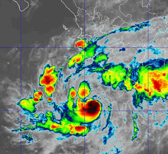
Tall thunderstorms formed near the center of Hurricane Simon. Bands of showers and thunderstorms were revolving around the center of Simon’s circulation. Storms near the center of Simon generated upper level divergence that pumped mass away from the hurricane. The removal of mass caused the surface pressure to decrease.
The circulation around Hurricane Simon was small. The strongest winds were occurring in the northeastern part of Simon’s circulation. Winds to hurricane force extended out 20 miles in the northeastern quadrant of Simon. Winds to tropical storm force extended out 90 miles (145 km) from the center of Hurricane Simon.
Hurricane Simon will move through an environment favorable for intensification during the next 24 hours. Simon will move over water where the Sea Surface Temperatures are near 30°C. It will move under the middle of an upper level ridge that is over Mexico and the Eastern North Pacific Ocean. The upper level ridge winds are weak near the middle of the ridge and there will be little vertical wind shear. Hurricane Simon will intensify during the next 24 hours. Simon could intensify rapidly at times. Hurricane Simon could strengthen to a major hurricane on Friday.
Hurricane Simon will move around the western part of a high pressure system that is over Mexico. The high pressure system will steer Simon toward the north during the next 24 hours. Hurricane Simon will approach the west coast of Mexico on Saturday.
Hurricane Simon is likely to be a major hurricane when it hits the west coast of Mexico. Simon will bring strong winds and locally heavy rain to the west coast of Mexico. The strongest winds and heaviest rains will occur in Jalisco and Nayarit. Heavy rain is likely to cause flash floods in some locations. Hurricane Simon could cause a storm surge of up to 13 feet (4 meters) along parts of the west coast of Mexico.
Elsewhere over the Eastern North Pacific Ocean, Tropical Storm Rachel continued to weaken gradually west of Baja California.
At 11:00 p.m. EDT on Thursday the center of Tropical Storm Rachel was located at latitude 22.6°N and longitude 125.5°W which put the center about 995 miles (1600 km) west of the southern tip of Baja California. Rachel was moving toward the west-northwest at 6 m.p.h. (10 km/h). The maximum sustained wind speed was 60 m.p.h. (95 km/h) and there were wind gusts to 75 m.p.h. (120 km/h). The minimum surface pressure was 990 mb.