Tag Archives: Tropical Storm Simon

Trudy Intensifies to a Major Hurricane

Hurricane Trudy intensified to a major hurricane on Thursday night as it moved over the Eastern North Pacific Ocean south of Mexico.  At 8:00 a.m. EDT on Friday the center of Hurricane Trudy was located at latitude 14.5°N and longitude 102.5°W which put the center about 240 miles (385 km) southwest of Acapulco, Mexico.  Trudy was moving toward the northwest at 6 m.p.h. (15 km/h). The maximum sustained wind speed was 120 m.p.h. (195 km/h) and there were wind gusts to 140 m.p.h. (225 km/h).  The minimum surface pressure was 956 mb.

A Hurricane Watch is in effect for the portion of the coast from Punta San Telmo to Cabo Corrientes, Mexico.

A Tropical Storm Warning is in effect for the portion of the coast from Manzanillo to Zihuatanejo, Mexico.

Hurricane Trudy intensified to a major hurricane on Thursday night.
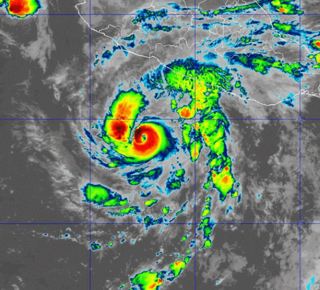
A circular eye with a diameter of 17 miles (28 km) was at the center of Hurricane Trudy.  The eye was surrounded by a ring of thunderstorms and the strongest winds were occurring in that ring of storms.  Bands of showers and thunderstorms were revolving around the core of Trudy’s circulation.  Storms near the core of Trudy generated upper level divergence that pumped mass away from the hurricane.  The removal of mass caused the surface pressure to decrease.

Winds to hurricane force extended out 30 miles (50 km) from the center of Hurricane Trudy.  Winds to tropical storm force extended out 140 miles (225 km) from the center of Trudy’ circulation.

The Hurricane Intensity Index (HII) for Hurricane Trudy is 22.1.  The Hurricane Size Index (HSI) is 20.3 and the Hurricane Wind Intensity Size Index (HWISI) is 42.4.  Hurricane Trudy is similar in intensity to Hurricane Milton when Milton hit Florida in 2024.  Trudy is not quite as large as Milton was.

Hurricane Trudy will move through an environment that will be favorable for intensification during the next 24 hours.  Trudy will move over water where the Sea Surface Temperatures are near 30°C.  It will move through a region where the upper level winds are weak and there will be little vertical wind shear.  Hurricane Trudy will intensify during the next 24 hours.

Hurricane Trudy will move around the western side of a high pressure system that is over Mexico.  The high pressure system will steer Trudy toward the northwest during the next 24 hours.  On its anticipated track, Hurricane Trudy will move closer to the coast of southwestern Mexico.

Elsewhere over the Eastern North Pacific Ocean, Tropical Storm Simon was weakening south of Baja California.  At 5:00 a.m. EDT on Friday the center of Tropical Storm Simon was located at latitude 20.0°N and longitude 108.8°W which put the center about 210 miles (335 km) south-southeast of Cabo San Lucas, Mexico.  Simon was moving toward the northwest at 9 m.p.h. (15 km/h).  The maximum sustained wind speed was 40 m.p.h. (65 km/h) and there were wind gusts to 50 m.p.h. (80 km/h).  The minimum surface pressure was 1002 mb.
Trudy Strengthens to a Hurricane

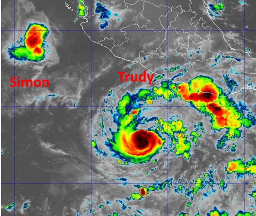
Former Tropical Storm Trudy strengthened to a hurricane on Wednesday night as it moved over the Eastern North Pacific Ocean south of Mexico.  At 5:00 a.m. EDT on Thursday the center of Hurricane Trudy was located at latitude 12.9°N and longitude 101.6°W which put the center about 300 miles (480 km) south-southwest of Acapulco, Mexico.  Trudy was moving toward the northwest at 9 m.p.h. (15 km/h).  The maximum sustained wind speed was 75 m.p.h. (120 km/h) and there were wind gusts to 90 m.p.h. (145 km/h).  The minimum surface pressure was 989 mb.

Former Tropical Storm Trudy strengthened to a hurricane on Wednesday night.

Tall thunderstorms were occurring near the center of Hurricane Trudy.  Thunderstorms were also occurring in bands revolving around the center of Trudy’s circulation.  Storms near the center of Trudy generated upper level divergence that pumped mass away from the hurricane.  The removal of mass caused the surface pressure to decrease.

The strongest winds were occurring in the northern side of Hurricane Trudy.  Winds to hurricane force extended out 25 miles (40 km) in the northern side of Trudy’s circulation.  Winds to tropical storm force extended out 115 miles (185 km) from the center of Hurricane Trudy.

Hurricane Trudy will move through an environment that will be favorable for intensification during the next 24 hours.  Trudy will move over water where the Sea Surface Temperatures are near 30°C.  It will move through a region where the upper level winds are weak and there will be little vertical wind shear.  Hurricane Trudy will intensify during the next 24 hours.  Trudy could rapidly intensify to a major hurricane by early on Friday.

Hurricane Trudy will move around the western side of a high pressure system that is over Mexico.  The high pressure system will steer Trudy toward the west-northwest during the next 24 hours.  On its anticipated track, Hurricane Trudy will move closer to the coast of southwestern Mexico.

Elsewhere over the Eastern North Pacific Ocean, Tropical Storm Simon was still meandering west of Mexico.  At 5:00 a.m. EDT on Thursday the center of Tropical Storm Simon was located at latitude 19.2°N and longitude 108.5°W which put the center about 200 miles (320 km) west-southwest of Cabo Corrientes, Mexico.  Simon was stationary.  The maximum sustained wind speed was 60 m.p.h. (95 km/h) and there were wind gusts to 75 m.p.h. (120 km/h).  The minimum surface pressure was 996 mb.

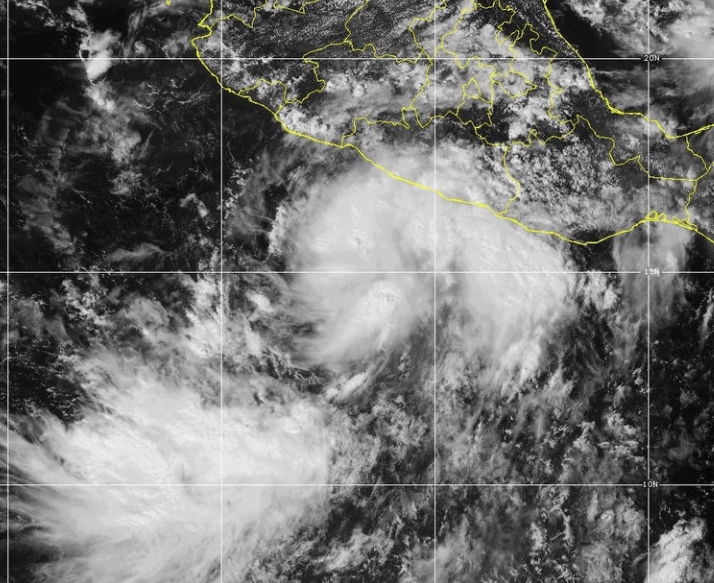
Tropical Storm Simon Forms South of Mexico

Tropical Storm Simon formed over the Eastern North Pacific Ocean south of Mexico on Wednesday.  At 5:00 p.m. EDT on Wednesday the center of Tropical Storm Simon was located at latitude 15.5°N and longitude 101.6°W which put the center about 175 miles (285 km) south-southeast of Lazaro Cardenas, Mexico.  Simon was moving toward the west-northwest at 8 m.p.h. (13 km/h).  The maximum sustained wind speed was 40 m.p.h. (65 km/h) and there were wind gusts to 50 m.p.h. (80 km/h).  The minimum surface pressure was 1004 mb.

A low pressure system over the Eastern North Pacific Ocean south of Mexico strengthened on Wednesday and the U.S. National Hurricane Center designated the system as Tropical Storm Simon.

Tropical Storm Simon exhibited better organization on Wednesday afternoon.  More thunderstorms were forming near the center of Simon’s circulation.  More thunderstorms also started to develop in bands revolving around the center of Tropical Storm Simon.  Storms near the center of Simon began to generate upper level divergence that pumped mass away from the tropical storm.  The removal of mass cause the surface pressure to start to decrease.

The strongest winds were occurring in the northeastern part of Tropical Storm Simon.  Winds to tropical storm force extended out 70 miles (110 km) in the northeastern quadrant of Simon’s circulation.  The winds in the other parts of Tropical Storm Simon were blowing at less than tropical storm force.

Tropical Storm Simon will move through an environment favorable for intensification during the next 24 hours.  Simon will move over water where the Sea Surface Temperatures are near 30°C.  It will move under the southern part of an upper level ridge that is over Mexico.  The upper level ridge will produce easterly winds that will blow toward the top of Simon’s circulation.  Those winds will cause some vertical wind shear, but the wind shear will not be enough to prevent intensification.  Tropical Storm Simon will intensify during the next 24 hours.

Tropical Storm Simon will move around the western part of a high pressure system that is over Mexico.  The high pressure system will steer Simon toward the west-northwest during the next 24 hours.  Simon will start to move toward the north on Friday when it reaches the western end of the high pressure system.  On its anticipated track, Tropical Storm Simon could approach the west coast of Mexico on Saturday.

Elsewhere over the Eastern North Pacific Ocean, Hurricane Rachel was still spinning west of Baja California.

At 5:00 p.m. EDT on Wednesday the center of Hurricane Rachel was located at latitude 21.2°N and longitude 122.3°W which put the center about 800 miles (1290 km) west of the southern tip of Baja California.  Rachel was moving toward the west-northwest at 7 m.p.h. (11 km/h).  The maximum sustained wind speed was 80 m.p.h. (130 km/h) and there were wind gusts to 100 m.p.h. (160 km/h).  The minimum surface pressure was 979 mb.