Monthly Archives: August 2024

Tropical Storm Maria Brings Wind and Rain to Northern Honshu

Tropical Storm Maria brought wind and rain to northern Honshu on Sunday night.  At 11:00 p.m. EDT on Sunday the center of Tropical Storm Maria was located at latitude 39.4°N and longitude 141.2°E which put the center about 10 miles (15 km) east of Hanamaki, Japan.  Maria was moving toward the northwest at 14 m.p.h. (22 km/h). The maximum sustained wind speed was 60 m.p.h. (95 km/h) and there were wind gusts to 75 m.p.h. (120 km/h).  The minimum surface pressure was 984 mb.

Tropical Storm Maria brought wind and rain to northern Honshu on Sunday night.  The center of Maria’s circulation made landfall near Kesennuma in Miyagi prefecture.  Tropical Storm Maria exhibited more organization as it neared landfall in northern Honshu.  A small circular eye appeared on both satellite images and radar images from the Japan Meteorological Agency.  The eye was surrounded by a ring of thunderstorms and the strongest winds were occurring in that ring of storms.  Bands of thunderstorms were revolving around the center of Maria’s circulation.

The circulation around Tropical Storm Maria was fairly symmetrical at the time of landfall.  Winds to tropical storm force extended out 120 miles (195 km) from the center of Maria’s circulation.

Tropical Storm Maria will move around the western end of a high pressure system over the North Pacific Ocean.  The high pressure system will steer Maria toward the northwest during the next 24 hours.  On its anticipated track, Tropical Storm Maria will move over Iwate and Akita prefectures.  Maria could move over the Sea of Japan in 12 hours.

Tropical Storm Maria will weaken steadily as it moves across northern Honshu.  Maria will continue to bring gusty winds and locally heavy rain to parts of Iwate and Akita prefectures during the next 12 to 24 hours.  Heavy rain could cause flash floods in some locations.

Tropical Storm Watches Issued for Leeward Islands

The potential threat posed by a tropical wave east of the Lesser Antilles prompted the issuance of Tropical Storm Watches for the Leeward Islands on Sunday afternoon.  The U.S. National Hurricane Center designated the tropical wave as Potential Tropical Cyclone Five for the purpose of issuing the Tropical Storm Watches.  At 5:00 p.m. EDT on Sunday the center of Potential Tropical Cyclone Five was located at latitude 13.6°N and longitude 48.0°W which put the center about 950 miles (1530 km) east-southeast of Antigua.  The tropical wave was moving toward the west-northwest at 21 m.p.h. (33 km/h).  The maximum sustained wind speed was 30 m.p.h. (50 km/h) and there were wind gusts to 40 m.p.h. (65 km/h).  The minimum surface pressure was 1010 mb.

Tropical Storm Watches were in effect for Guadeloupe, St. Martin, St, Kitts, Nevis, Montserrat, Antigua, Barbuda, and Anguilla, Saba and St. Eustatius, and Sin Maarten.

The U.S. National Hurricane Center designated a tropical wave east of the Lesser Antilles as Potential Tropical Cyclone Five on Sunday afternoon.  There was not a well defined low level center of circulation in the tropical wave.  There was a large counterclockwise rotation associated with the tropical wave, but the rotation did not have an identifiable center.  Thunderstorms were forming in clusters scattered within the tropical wave.

Potential Tropical Cyclone Five will move through an environment somewhat favorable for the formation of a tropical cyclone during the next 36 hours.  The tropical wave will move over water where the Sea Surface Temperatures are near 29°C.  It will move under the southern part of an upper level ridge over the subtropical Atlantic Ocean.  The ridge will produce strong easterly winds that will blow toward the top of the tropical wave.  Those winds will cause moderate vertical wind shear.  The wind shear will slow the organization of the tropical wave into a tropical cyclone.  Potential Tropical Cyclone Five is likely to organize gradually into a tropical depression or a tropical storm during the next 36 hours.

Potential Tropical Cyclone Five will move around the southern side of a subtropical high pressure system over the Atlantic Ocean.  The high pressure system will steer the tropical wave quickly toward the west-northwest during the next 36 hours.  On its anticipated track, Potential Tropical Cyclone Five could approach the Leeward Islands on Monday night.

Potential Tropical Cyclone Five could be a tropical storm when it reaches the Leeward Islands.  It will bring gusty winds and locally heavy rain to the Leeward Islands.  Heavy rain is likely to cause flash floods in some locations.
Tropical Storm Maria Moves Toward Northern Honshu

Tropical Storm Maria moved toward northern Honshu on Saturday night.  At 11:00 p.m. EDT on Saturday the center of Tropical Storm Maria was located at latitude 37.7°N and longitude 144.4°E which put the center about 235 miles (355 km) east-southeast of Sendai, Japan.  Maria was moving toward the north-northwest at 9 m.p.h. (15 km/h).  The maximum sustained wind speed was 60 m.p.h. (95 km/h) and there were wind gusts to 75 m.p.h. (120 km/h).  The minimum surface pressure was 981 mb.

Tropical Storm Maria exhibited more organization on Saturday night as it moved closer to northern Honshu.  The inner end of a rainband wrapped around the center of Maria’s circulation.  A small circular eye appeared intermittently on satellite images.  Bands of showers and thunderstorms revolved around the center of Tropical Storm Maria.  Storms near the center generated upper level divergence that pumped mass away from the tropical storm.

The distribution of wind speeds around Tropical Storm Maria was more symmetrical on Saturday.  Winds to tropical storm force extended out 155 miles (250 km) from the center to Maria’s circulation.

Tropical Storm Maria will move through an environment somewhat favorable for intensification during the next 18 hours.  Maria will move over water where the Sea Surface Temperatures are near 28°C.  It will move under the eastern part of an upper level ridge over Japan.  The upper level winds are weak in that part of the ridge and there will be little vertical wind shear.  Tropical Storm Maria could intensify during the next 18 hours, but it is more likely that Maria will maintain its current intensity.

Tropical Storm Maria will move around the southwestern part of a high pressure system over the North Pacific Ocean.  The high pressure system will steer Maria toward the west-northwest during the next 24 hours.  On its anticipated track, Tropical Storm Maria will approach the coast of northern Honshu in less than 24 hours.

Tropical Storm Maria will bring strong winds and locally heavy rain to northern Honshu.  Heavy rain could cause flash floods in some locations.

Tropical Storm Maria Spins East of Japan

Tropical Storm Maria was spinning east of Japan on Friday.  At 5:00 p.m. EDT on Friday the center of Tropical Storm Maria was located at latitude 34.5°N and longitude 145.8°E which put the center about 400 miles (645 km) east of Tokyo, Japan.  Maria was moving toward the north at 15 m.p.h. (24 km/h).  The maximum sustained wind speed was 50 m.p.h. (80 km/h) and there were wind gusts to 65 m.p.h. (105 km/h).  The minimum surface pressure was 987 mb.

Former Typhoon Maria weakened back to a tropical storm over the Western North Pacific Ocean east of Japan on Friday.  The wind in the western part of Maria appeared to pull drier air around the southern side of Maria’s circulation.  The drier caused many of the thunderstorms in southern side of Tropical Storm Maria to dissipate.  Bands in the southern half of Maria’s circulation consisted primarily of showers and lower clouds.  Thunderstorms were still occurring in bands in the northern half of Tropical Storm Maria.

The distribution of wind speeds in Tropical Storm Maria was asymmetrical.  Winds to tropical storm force extended out 140 miles (225 km) in the eastern side of Maria’s circulation.  Winds to tropical storm force only extended out 85 miles (135 km) in the western side of Tropical Storm Maria.

Tropical Storm Maria will move through an environment somewhat favorable for intensification during the next 24 hours.  Maria will move over water where the Sea Surface Temperatures are near 28°C.  It will move under the eastern part of an upper level trough over Japan.  The upper level trough will produce southwesterly winds that will blow toward the top of Maria’s circulation.  Those winds will cause some vertical wind shear.  The vertical wind shear and the drier air in Tropical Storm Maria will inhibit intensification.  Tropical Storm Maria could intensify during the next 24 hours even with the effects of the wind shear and drier air.

Tropical Storm Maria will move around the western side of a high pressure system over the Western North Pacific Ocean.  The high pressure system will steer Maria toward the north during the next 24 hours.  On its anticipated track, Tropical Storm Maria will move closer to eastern Japan.  Maria could start to move toward Honshu during the weekend.


Maria Intensifies to a Typhoon Southeast of Japan

Former Tropical Storm Maria intensified to a typhoon southeast of Japan on Thursday.  At 5:00 p.m. EDT on Thursday the center of Typhoon Maria was located at latitude 30.5°N and longitude 145.8°E which put the center about 505 miles (815 km) southeast of Tokyo, Japan.  Maria was moving toward the north at 14 m.p.h. (22 km/h).  The maximum sustained wind speed was 80 m.p.h. (130 km/h) and there were wind gusts to 100 m.p.h. (160 km/h).  The minimum surface pressure was 969 mb.

Former Tropical Storm Maria intensified to a typhoon over the Western North Pacific Ocean southeast of Japan on Thursday.  A small circular eye formed at the center of Maria’s circulation.  The eye was surrounded by a ring of thunderstorms and the strongest winds were occurring in that ring of storms.  Bands of showers and thunderstorms revolved around the core of Typhoon Maria.  Storm near the core generated upper level divergence that pumped mass away from the typhoon.  The removal of mass caused the surface pressure to decrease.

The circulation around Typhoon Maria was very small.  Winds to typhoon force extended out 25 miles (40 km) in the eastern side of Maria’s circulation.  Winds to tropical storm force extended out 70 miles (110 km) from the center of Typhoon Maria.

Typhoon Maria will move through an environment favorable for intensification during the next 24 hours.  Maria will move over water where the Sea Surface Temperatures are near 30°C.  It will move under the southeastern part of an upper level trough over Japan.  The upper level trough will produce southwesterly winds that will blow toward the top of Maria’s circulation.  Those winds will cause some vertical wind shear, but the wind shear will not be enough to prevent intensification.  Tropical Storm Maria is likely to continue to intensify during the next 24 hours.

Typhoon Maria will move around the western side of a high pressure system over the Western North Pacific Ocean.  The high pressure system will steer Maria toward the north during the next 24 hours.  On its anticipated track, Typhoon Maria will move closer to eastern Japan.


Tropical Storm Debby Moves Inland

Tropical Storm Debby moved inland over the eastern U.S. on Thursday morning.  At 2:00 p.m. EDT on Thursday the center of Tropical Storm Debby was located at latitude 34.8°N and longitude 80.2°W which put the center about 55 miles (90 km) east-southeast of Charlotte, North Carolina.  Debby was moving toward the north-northwest at 10 m.p.h. (16 km/h).  The maximum sustained wind speed was 40 m.p.h. (65 km/h) and there were wind gusts to 50 m.p.h. (80 km/h).  The minimum surface pressure was 997 mb.

A Tropical Storm Warning was in effect for the portion of the coast from Surf City to Ocracoke Inlet, North Carolina.

Tropical Storm Debby weakened gradually as it moved inland over South Carolina on Thursday morning.  The strongest winds were in bands in the part of Tropical Storm Debby that was still over the Atlantic Ocean.  Winds to tropical storm force extended out 195 miles (315 km) east of the center of Debby’s circulation.  The winds were blowing at less than tropical storm force in the parts of Debby that were over land.

Bands of thunderstorms in the northern and eastern parts of Tropical Storm Debby were dropping heavy rain over eastern North Carolina and southern Virginia.  Flood Warnings were in effect for many counties in eastern North Carolina.

The Lumber River at Lumberton, North Carolina was at 17.73 feet (5.40 meters) which was in the Moderate Flood range.  The river was still rising.  The Rock River near Norwood, North Carolina was at 26.73 feet (8.15 meters) which was in the Minor Flood range.  The river was still rising.  The Little River at Manchester, North Carolina was at 23.46 feet (7.15 meters) which is in the Moderate Flood range.  The river was still rising.  The Little Pee Dee River near Galivants Ferry, South Carolina was at 9.25 feet (2.82 meters) which is in the Minor Flood range.  The river was still rising.

An upper level trough approaching the Great Lakes will steer Tropical Storm Debby more quickly toward the northeast during the next 24 hours.  Debby will weaken to a tropical depression during the next few hours.  Even though the wind speeds will decrease further, Tropical Storm Debby will continue to drop heavy rain on the eastern side of the Appalachian Mountains.  Heavy rain is likely to cause floods in additional locations.

Flood Watches are in effect for North Carolina, Virginia, eastern West Virginia, central Pennsylvania, central and northeastern New York, northern Vermont, and northern New Hampshire.

Tropical Storm Debby Drops Heavy Rain on the Carolinas

Tropical Storm Debby dropped heavy rain on the Carolinas on Wednesday night.  At 11:00 p.m. EDT on Wednesday the center of Tropical Storm Debby was located at latitude 32.9°N and longitude 79.5°W which put the center about 25 miles (40 km) east-northeast of Charleston, South Carolina.   Debby was moving toward the north-northwest at 3 m.p.h. (5 km/h).   The maximum sustained wind speed was 60 m.p.h. (95 km/h) and there were wind gusts to 75 m.p.h. (120 km/h).  The minimum surface pressure was 994 mb.

A Tropical Storm Warning was in effect for the portion of the coast from Edisto Beach, South Carolina to Surf City, North Carolina.  The Tropical Storm Warning included Charleston, South Carolina.

A Tropical Storm Watch was in effect for the portion of the coast from Surf City to Beaufort Inlet, North Carolina.

Bands in the northern part of Tropical Storm Debby dropped heavy rain on eastern South Carolina and eastern North Carolina.  There were Flood Warnings for a number of rivers in eastern South Carolina and eastern North Carolina including the Cape Fear River, the Lumber River, the Little Pee Dee River and the Great Pee Dee River.

Drier air was still present near the center of Tropical Storm Debby.  There were a few thunderstorms near the center of Debby, but much of the middle of Debby’s circulation consisted of showers and lower clouds.  Thunderstorms were occurring in bands in the outer parts of the circulation in northern side of Tropical Storm Debby.  Thunderstorms were also occurring in bands in outer parts of the circulation in the southern side of Debby.

The distribution of winds in Tropical Storm Debby continued to be asymmetrical.  Winds to tropical storm force extended out 185 miles (300 km) in the eastern side of Debby’s circulation.  Winds to tropical storm force extended out 105 miles (165 km) in the southwestern quadrant of Tropical Storm Debby.  The winds in the northwestern quadrant, which was mostly over land, were blowing at less than tropical storm force.

Tropical Storm Debby will move through an environment marginally favorable for intensification during the next few hours.  Debby will move over water where the Sea Surface Temperatures are near 29°C.  It will move under the middle of an upper level ridge over the southeastern U.S.  The upper level winds are weak near the center of the ridge and there will be little vertical wind shear.  The drier air in the middle part of Debby’s circulation will inhibit intensification. Tropical Storm Debby is likely to maintain its intensity during the next few hours.

Tropical Storm Debby will move around the western side of high pressure system over the western Atlantic Ocean.  The high pressure system will steer Debby slowly toward the north during the next 24 hours.  On its anticipated track, the center of Tropical Storm Debby will cross the coast of South Carolina on Wednesday night.  An upper level trough approaching the Great Lakes will steer Debby more quickly toward the northeast on Friday.

Tropical Storm Debby will continue to drop heavy rain on parts of South Carolina and North Carolina on Thursday.  Since Debby will move slowly, persistent heavy rain is likely to cause floods in some locations.  Tropical Storm Debby will drop heavy rain on the eastern slopes of the Appalachian Mountains on Friday.

Flood Watches are in effect for parts of South Carolina, North Carolina, Virginia, western Maryland, eastern West Virginia, and Pennsylvania.

Southerly winds blowing around the eastern side of Tropical Storm Debby will continue to push water toward the coast of South Carolina and North Carolina.  Debby could cause a storm surge of up to 4 feet (1 meter).


The wind

Tropical Storm Emilia Absorbs Fabio

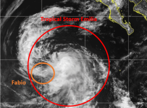
The circulation around Tropical Storm Emilia absorbed the circulation of former Tropical Storm Fabio on Wednesday afternoon.

At 5:00 p.m. EDT on Wednesday the center of Tropical Storm Emilia was located at latitude 19.1°N and longitude 117.7°W which put the center about 565 miles (910 km) west-southwest of the southern tip of Baja California.  Emilia was moving toward the northwest at 18 m.p.h. (30 km/h).  The maximum sustained wind speed was 65 m.p.h. (105 km/h) and there were wind gusts to 80 m.p.h. (130 km/h).  The minimum surface pressure was 990 mb.

At 5:00 p.m. EDT on Wednesday the center of former Tropical Storm Fabio was located at latitude 18.4°N and longitude 120.2°W which put the center about 735 miles (1180 km) west-southwest of the southern tip of Baja California.  Fabio was moving toward the southwest at 16 m.p.h. (26 km/h).  The maximum sustained wind speed was 40 m.p.h. (65 km/h) and there were wind gusts to 50 m.p.h. (80 km/h).  The minimum surface pressure was 1004 mb.

The larger circulation around Tropical Storm Emilia absorbed the smaller circulation around Tropical Storm Fabio on Wednesday.

The absorption of Fabio’s circulation did disrupt the circulation around Tropical Storm Emilia, especially on the western side of its circulation.  Bands in the northern and western parts of Tropical Storm Emilia consisted primarily of showers and lower clouds.  Thunderstorms were still occurring in bands in the southern and eastern parts of Emilia’s circulation.  The interactions of the two circulations also inhibited upper level divergence to the north and west of Tropical Storm Emilia.

Winds to tropical storm force extended out 115 miles (185 km) from the center of Tropical Storm Emilia.

Tropical Storm Emilia will move into an environment that will become unfavorable for intensification during the next 24 hours.  Emilia will move move over water where the Sea Surface Temperatures are near 25°C.  It will move under the axis of an upper level ridge over the Eastern North Pacific Ocean.  The upper level winds are weak near the axis of the ridge and there will be little vertical wind shear.  Tropical Storm Emilia will weaken when it moves over cooler water on Thursday.

Tropical Storm Emilia will move around the southern part of a subtropical high pressure system over the Eastern North Pacific Ocean.  The high pressure system will steer Emilia toward the west-northwest during the next 24 hours.  On its anticipated track, Tropical Storm Emilia will move farther away from Baja California.

Tropical Storm Maria Forms South of Japan

Tropical Storm Maria formed south of Japan on Wednesday.  At 5:00 p.m. EDT on Wednesday the center of Tropical Storm Maria was located at latitude 26.1°N and longitude 143.3°E which put the center about 695 miles (1120 km) south-southeast of Tokyo, Japan.  Maria was moving toward the east-northeast at 7 m.p.h. (11 km/h).  The maximum sustained wind speed was 45 m.p.h. (75 km/h) and there were wind gusts to 60 m.p.h. (95 km/h).  The minimum surface pressure was 994 mb.

A low pressure system over the Western North Pacific Ocean south-southeast of Tokyo strengthened on Wednesday and the Japan Meteorological Agency designated the system as Tropical Storm Maria.  More thunderstorms formed near the center of Maria’s circulation.  More thunderstorms also developed in bands in the southern and eastern parts of Tropical Storm Maria.  Bands in the northern and western parts of Maria consisted primarily of showers and lower clouds.  Storms near the center of Maria’s circulation began to generate upper level divergence that pumped mass away from the tropical storm.

Winds to tropical storm force extended out 120 miles (195 km) from the center of Tropical Storm Maria.

Tropical Storm Maria will move through an environment favorable for intensification during the next 24 hours.  Maria will move over water where the Sea Surface Temperatures are near 30°C.  It will move under the southeastern part of an upper level trough over Japan.  The upper level trough will produce southwesterly winds that will blow toward the top of Maria’s circulation.  Those winds will cause some vertical wind shear, but the wind shear will not be enough to prevent intensification.  Tropical Storm Maria will intensify during the next 24 hours.  Maria could strengthen to a typhoon by Friday.

Tropical Storm Maria will move around the western side of a high pressure system over the Western North Pacific Ocean.  The high pressure system will steer Maria toward the north during the next 24 hours.  On its anticipated track, Tropical Storm Maria will move closer to eastern Japan.

Tropical Storm Debby Strengthens

Tropical Storm Debby strengthened over the Atlantic Ocean southeast of South Carolina on Wednesday.  At 2:00 p.m. EDT on Wednesday the center of Tropical Storm Debby was located at latitude 32.4°N and longitude 79.1°W which put the center about 55 miles (90 km) east-southeast of Charleston, South Carolina.  Debby was moving toward the northeast at 3 m.p.h. (5 km/h).  The maximum sustained wind speed was 60 m.p.h. (95 km/h) and there were wind gusts to 75 m.p.h. (120 km/h). The minimum surface pressure was 995 mb.

A Tropical Storm Warning was in effect for the portion of the coast from Savannah River Georgia to Surf City, North Carolina.  The Tropical Storm Warning included Charleston, South Carolina.

A Tropical Storm Watch was in effect for the portion of the coast from Surf City to Beaufort Inlet, North Carolina.

Tropical Storm Debby strengthened on Wednesday morning as it moved slowly over the Atlantic Ocean southeast of South Carolina.  A U.S. Air Force Reserve Hurricane Hunter aircraft found winds to 60 m.p.h. (95 km/h) in a band more than 100 miles (160 km) southeast of the center of Debby’s circulation.  The winds in the other parts of Tropical Storm Debby were not as strong.

More thunderstorms began to form in bands revolving around the center of Tropical Storm Debby after more of Debby’s circulation moved over the Atlantic Ocean.  There were only a few thunderstorms near the center of Debby’s circulation because drier air was still present in the middle of that circulation.  However, more water vapor was evaporating into the air and the air was becoming moister.  Some of the thunderstorms in Debby started to generate more upper level divergence that pumped mass away from the tropical storm  The removal of mass caused the surface pressure to decrease slowly.

The distribution of wind speed around Tropical Storm Debby was very asymmetrical.  The strongest winds were occurring in the southeastern quadrant of Debby’s circulation.  Winds to tropical storm force extended out 185 miles (300 km) in the southeastern quadrant of Tropical Storm Debby.  Winds to tropical storm force extended 140 miles (225 km) in the northeastern and southwestern quadrants of Debby’s circulation.  The winds in the northwestern quadrant of Tropical Storm Debby were blowing at less than tropical storm force.

Tropical Storm Debby will move through an environment favorable for intensification during the next few hours.  Debby will move over water where the Sea Surface Temperatures are near 29°C.  It will move under the middle of an upper level ridge over the southeastern U.S.  The upper level winds are weak near the center of the ridge and there will be little vertical wind shear.  The drier air in the middle part of Debby’s circulation will inhibit intensification.  Tropical Storm Debby could continue to intensify slowly during the next few hours.

Tropical Storm Debby will move around the western side of high pressure system over the western Atlantic Ocean.  The high pressure system will steer Debby slowly toward the north during the next 24 hours.  On its anticipated track, the center of Tropical Storm Debby will approach the coast of South Carolina on Wednesday night.

Tropical Storm Debby will continue to drop heavy rain on parts of South Carolina, North Carolina and eastern Georgia.   Since Debby will move slowly, persistent heavy rain is likely to cause floods in some locations.

Flood Watches are in effect for parts of South Carolina, North Carolina and eastern Georgia.

Southerly winds blowing around the eastern side of Tropical Storm Debby will continue to push water toward the coast of South Carolina and North Carolina.  Debby could cause a storm surge of up to 6 feet (1.8 meters).