
Tag Archives: Bahia Kino

Hurricane Polo Hits Sonora

Hurricane Polo hit Sonora on Tuesday morning after crossing the southern part of Baja California on Monday night.
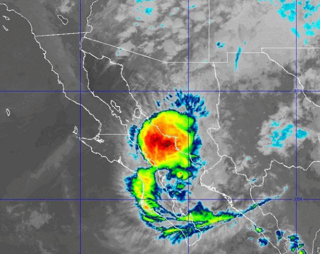
At 8:00 a.m. EDT on Tuesday the center of Hurricane Polo was located at latitude 26.9°N and longitude 111.7°W which put the center about 90 miles (145 km) south-southwest of Guaymas, Mexico.  Polo was moving toward the northeast at 10 m.p.h. (16 km/h).  The maximum sustained wind speed was 75 m.p.h. (120 km/h) and there were wind gusts to 90 m.p.h. (145 km/h).  The minimum surface pressure was 981 mb.

A Hurricane Warning is in effect for the portion of the west coast of Baja California from Punta Abreojos to Santa Fe, Mexico.

A Hurricane Warning is in effect for the portion of the east coast of Baja California from  Loreto to Bahia San Juan Bautista, Mexico.

A Hurricane Warning is in effect for the portion of the coast from Bahia Kino to Huatabampito, Mexico.

A Tropical Storm Warning and a Hurricane Watch is in effect for the portion of the coast from Loreto to San Evaristo, Mexico.

A Tropical Storm Warning and a Hurricane Watch is in effect for the portion of the coast from Huatabampito to Topolobampo, Mexico.

A large upper level trough over the western U.S. was producing strong southwesterly winds that were blowing toward the top of Hurricane Polo.  Those winds were causing strong vertical wind shear.  Those winds were also blowing the upper part of Polo’s circulation to the northeast of the lower level circulation.  The upper part of Hurricane Polo was already over Sonora.  The lower part of Polo’s circulation was near the coast south of Guaymas.

Hurricane force winds extended out 30 miles (50 km) from the center of the surface circulation around Hurricane Polo.  Tropical storm force winds extended out 90 miles from the center of the surface circulation.

The upper level trough over the western U.S. will steer Hurricane Polo toward the northeast during the next 24 hours.  On its anticipated track, Hurricane Polo will move across northern Mexico toward New Mexico.

The strong vertical wind shear and the mountains in northern Mexico will cause the surface circulation around Hurricane Polo to weaken quickly.  The upper part of Hurricane Polo could reach southern New Mexico on Tuesday night.

Hurricane Polo will continue to produce strong winds and heavy rain over Sonora during the next few hours.  Heavy rain will cause flash floods in some locations.

Hurricane Polo could also drop locally heavy rain over parts of northern Mexico and New Mexico.

Flood Watches are in effect for much of New Mexico.

Elsewhere over the Eastern North Pacific Ocean, Tropical Storm Rachel was gradually getting better organized.

At 8:00 a.m. EDT on Tuesday the center of Tropical Storm Rachel was located at latitude 15.1°N and longitude 104.8°W which put the center about 370 miles (595 km) south of Cabo Corrientes, Mexico.   Rachel was moving toward the west-northwest at 13 m.p.h. (21 km/h).  The maximum sustained wind speed was 60 m.p.h. (95 km/h) and there were wind gusts to 75 m.p.h. (120 km/h).  The minimum surface pressure was 992 mb.

A Tropical Storm Warning is in effect for the portion of the coast from Punta San Telmo to Playa, Perula, Mexico.

A Tropical Storm Watch is in effect for the portion of the coast from Playa Perula to Cabo Corrientes, Mexico.
Hurricane Polo Nears Southern Baja California

Hurricane Polo moved nearer to the coast of southern Baja California on Sunday evening.

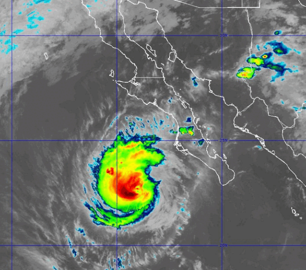
At 11:00 p.m. EDT on Sunday the center of Hurricane Polo was located at latitude 22.8°N and longitude 114.0°W which put the center about 175 miles (280 km) southwest of Cabo San Lazaro, Mexico.  Polo was moving toward the north at 12 m.p.h. (19 km/h).  The maximum sustained wind speed was 125 m.p.h. (200 km/h) and there were wind gusts to 150 m.p.h. (240 km/h).  The minimum surface pressure was 951 mb.

A Hurricane Warning is in effect for the portion of the west coast of Baja California from Punta Abreojos to Santa Fe, Mexico.

A Hurricane Warning is in effect for the portion of the east coast of Baja California from  Loreto to Santa Rosalia, Mexico.

A Hurricane Warning is in effect for the portion of the coast from Guaymas to Huatabampito, Mexico.

A Tropical Storm Warning and a Hurricane Watch  is in effect for the portion of the coast from Punta Eugenia to Punta Abreojos, Mexico.

A Tropical Storm Warning and a Hurricane Watch is in effect for the portion of the coast from ; Loreto to San Evaristo, Mexico.

A Tropical Storm Warning and a Hurricane Watch is in effect for the portion of the coast from Santa Rosalia to Bahia San Juan Bautista, Mexico

A Tropical Storm Warning and a Hurricane Watch is in effect for the portion of the coast from Guaymas to Bahia Kino, Mexico.

A Tropical Storm Warning and a Hurricane Watch is in effect for the portion of the coast from Huatabampito to Topolobampo, Mexico.

Hurricane Polo was still a major hurricane on Sunday evening.  A circular eye with a diameter of 17 miles (28 km) was present at the center of Polo’s circulation.  The eye was surrounded by a ring of thunderstorms and the strongest winds were occurring in that ring of storms.  Bands of showers and thunderstorms were revolving around the center of Hurricane Polo.  Storms near the center of Polo generated upper level divergence that pumped mass away from the hurricane.  The removal of mass in the upper levels was nearly equal to the convergence of mass in the lower levels of the atmosphere.  So, the surface pressure did not change much on Sunday.

The distribution of wind speeds in Hurricane Polo was fairly symmetrical.  Winds to hurricane force extended out 45 miles (75 km) from the center of Polo’s circulation.  Winds to tropical storm force extended out 105 miles (165 km) from the center of Hurricane Polo.

The Hurricane Intensify Index (HII) for Hurricane Polo is 23.4. The Hurricane Size Index (HSI) is 14.6 and the Hurricane Wind Intensity Size Index (HWISI) is 38.0.  Hurricane Polo is similar in size and intensity to Hurricane Milton when Milton hit Florida in 2024.

Hurricane Polo will move through an environment that will be unfavorable for intensification during the next 24 hours.  Polo will move over water where the Sea Surface Temperatures are near 28°C.  However, Polo will move under the southern part of an upper level trough that is near the West Coast of the U.S.  The upper level trough will produce southwesterly winds that will blow toward the top of Polo’s circulation.  Those winds will cause the vertical wind shear to increase on Monday.  Hurricane Polo will weaken during the next 24 hours because of more vertical wind shear.

The upper level trough near the West Coast of the U.S. will pull Hurricane Polo toward the northeast during the next 24 hours.  On its anticipated track, the center of Hurricane Polo will make landfall on the coast of southwest Baja California north of Cabo San Lazaro on Monday afternoon.

Hurricane Polo will bring strong winds and heavy rain to southern Baja California. Heavy rain is likely to cause flash floods in some locations.

Elsewhere over the Eastern North Pacific Ocean, Tropical Storm Rachel formed south of Mexico.

At 11:00 p.m. EDT on Sunday the center of Tropical Storm Rachel was located at latitude 12.9°N and longitude 99.8°W which put the center about 275 miles (445 km) south-southwest of Acapulco, Mexico.  Rachel was moving toward the west at 7 m.p.h. (11 km/h).  The maximum sustained wind speed was 40 m.p.h. (65 km/h) and there were wind gusts to 50 m.p.h. (80 km/h).  The minimum surface pressure was 1003 mb.

A Tropical Storm Watch is in effect for the portion of the coast from Punta San Telmo to Playa, Perula, Mexico.