Tropical Depression Eta Prompts Watches for South Florida, Keys and Northwest Bahamas

Expected intensification of Tropical Depression Eta prompted the issuance of Tropical Storm Watches for parts of South Florida, the Florida Keys and the Northwestern Bahamas. At 10:00 p.m. EST on Friday the center of Tropical Depression Eta was located at latitude 18.0°N and longitude 85.2°W which put it about 275 miles (445 km) west-southwest of Gran Cayman Island. Eta was moving toward the northeast at 12 m.p.h. (19 km/h). The maximum sustained wind speed was 35 m.p.h. (55 km/h) and there were wind gusts to 45 m.p.h. (75 km/h). The minimum surface pressure was 1002 mb.

Tropical Storm Warnings were in effect for the Cayman Islands and the Cuban provinces of Camaguey, Ciego de Avila, Sancti Spiritus, Villa Clara, Cienfuegos and Matanzas. A Tropical Storm Watch was issued for the coast of South Florida from Jupiter Inlet to Bonita Beach. It included Lake Okeechobee. A Tropical Storm Watch was issued for the Florida Keys from Ocean Reef to the Dry Tortugas. A Tropical Storm Watch was in effect for the Cuban provinces of La Habana, Artemisa y Mayabeque, Pinar del Rio and the Isle of Youth. A Tropical Storm Watch was issued for the Northwestern Bahamas including the Abacos, Andros Island, the Berry Islands, Bimini, Eleuthera, Grand Bahama Island and New Providence.

The structure of the circulation around Tropical Depression Eta exhibited a little more organization on satellite imagery on Friday evening. More thunderstorms developed near the center of Eta. There were also more thunderstorms in bands in the eastern half of the circulation. Bands in the western half of Eta contained more showers and lower clouds. Storms near the center of Eta generated upper level divergence which pumped mass away to the northeast of the depression. Removal of mass could allow the surface pressure to decrease on Saturday.

Tropical Depression Eta will move through an environment favorable for intensification on Saturday. Eta will move over water where the Sea Surface Temperature is near 29°C. It will initially be under an upper level ridge where the winds are weaker. There will be less vertical wind shear under the ridge and Eta is likely to strengthen back to a tropical storm on Saturday. A upper level low over the western Gulf of Mexico will produce southwesterly winds which will blow toward the top of Eta on Sunday. Those winds will cause more vertical wind shear, which could limit further intensification of Eta. Eta is also likely to weaken when it crosses Cuba on Sunday. The Sea Surface Temperature of the water north of Cuba is near 29°C. So, Eta is likely to strengthen after it crosses Cuba. Eta could strengthen to a hurricane when it approaches South Florida. The wind shear caused by the upper low could eventually cause Eta to develop a structure more like a subtropical cyclone.

The upper low over the western Gulf of Mexico will be the primary feature steering Eta. Counterclockwise rotation around the cutoff low will pull Eta more toward the northeast on Saturday. Eta could pass near the Cayman Islands on Saturday. Eta is likely to move across Cuba on Sunday morning and it could drop heavy rain when it does so. The upper low will steer Eta toward the northwest on Sunday. Eta will approach South Florida and the Florida Keys on Sunday night. It could bring gusty winds and locally heavy rain to the Keys and South Florida. A high pressure system over the Atlantic Ocean will interact with the circulation around the northern side of Eta to produce strong easterly winds which will blow toward the coast of Southeast Florida. Those winds will push water toward the coast and the water level will rise several feet.

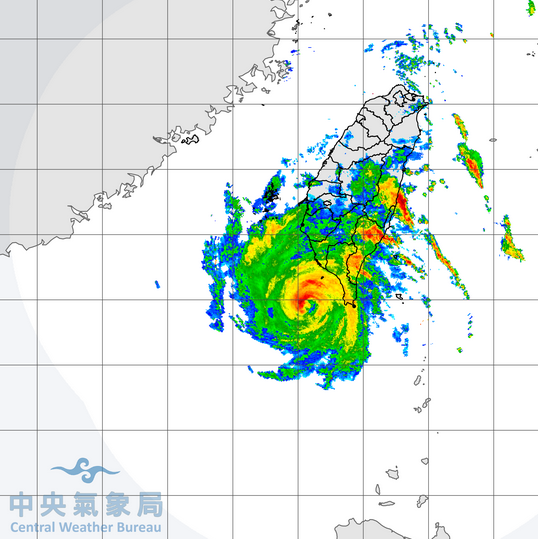
Tropical Storm Atsani Passes Just South of Taiwan

Tropical Storm Atsani passed just south of Taiwan early on Friday. At 4:00 a.m. EST on Friday the center of Tropical Storm Atsani was located at latitude 21.5°N and longitude 120.7°E which put it about 30 miles (50 km) south of Taiwan. Atsani was moving toward the west-northwest at 12 m.p.h. (19 km/h). The maximum sustained wind speed was 60 m.p.h. (95 km/h) and there were wind gusts to 75 m.p.h. (120 km/h). The minimum surface pressure was 995 mb.

The center of Tropical Storm Atsani passed just to the south of the southern tip of Taiwan early on Friday. Radar images from the Taiwan Central Weather Bureau showed the well organized structure of Tropical Storm Atsani.

There was a small, tight center of circulation. The center was surrounded by a partial eyewall and the strongest winds were occurring in eyewall. Multiple bands of showers and thunderstorms were revolving around the core of Tropical Storm Atsani. Bands in the northern half of Atsani were dropping heavy rain over the southern half of Taiwan. The heaviest rain was falling in parts of southeastern Taiwan where the wind was pushing air up the eastern slopes of mountains. Flash floods are possible in those areas. Winds to tropical storm force extended out 100 miles (160 km) from the center of Atsani.

Tropical Storm Atsani will be in an environment favorable for intensification during the next 12 to 24 hours. Atsani will move over water where the Sea Surface Temperature is near 28°C. It will be in an area where the upper level winds are weaker and there will be little vertical wind shear. Tropical Storm Atsani could intensify during the next 24 hours and there is a chance it could strengthen into a typhoon. An upper level trough over eastern Asia will approach Atsani during the weekend. The trough will produce stronger southwesterly winds which will cause more vertical wind shear. Tropical Storm Atsani will weaken when the wind shear increases. If the shear is strong enough, the upper level winds could blow the top half of Atsani northeast of the low level circulation.

Tropical Storm Atsani will move south of a ridge of high pressure over the Western North Pacific Ocean. The high will steer Atsani toward the west during the next day or so. If the wind shear blows the top half of Tropical Storm Atsani northeast of the lower level circulation, then a surface high pressure system over eastern Asia could push the lower half of Atsani toward the southeast. On its anticipated track Tropical Storm Atsani will pass southeast of Hong Kong and it could eventually move toward Vietnam.

Elsewhere over the Western North Pacific Ocean, the remnants of former Typhoon Goni were dropping heavy rain over parts of Vietnam. At 4:00 a.m. EST on Friday the center of Tropical Depression Goni was located at latitude 13.8°N and longitude 108.3°E which put it about 50 miles (80 km) west of Quy Nhon, Vietnam. Goni was moving toward the west at 7 m.p.h. (11 km/h). The maximum sustained wind speed was 30 m.p.h. (50 km/h) and there were wind gusts to 40 m.p.h. (65 km/h). The minimum surface pressure was 1003 mb. Tropical Depression Goni is dropping heavy rain over ground that is already saturated and the rain will make ongoing floods worse.

Potential Redevelopment of Eta Prompts Tropical Storm Watch for Cayman Islands

Potential redevelopment of former Hurricane Eta prompted the issuance of a Tropical Storm Watch for the Cayman Islands. At 4:00 p.m. EST on Thursday the center of Tropical Depression Eta was located at latitude 15.7°N and longitude 87.7°W which put it about 60 miles (95 km) west of La Ceiba, Honduras. Eta was moving toward the north-northwest at 8 m.p.h. (13 km/h). The maximum sustained wind speed was 35 m.p.h. (55 km/h) and there were wind gusts to 45 m.p.h. (75 km/h). The minimum surface pressure was 1005 mb.

A Tropical Storm Watch was issued for the Cayman Islands.

The low level center of former Hurricane Eta appeared to move north-northwest across Honduras on Thursday. Mountains in Honduras disrupted the surface circulation around Tropical Depression Eta as the day went on and the center became less distinct. That created more uncertainty about the location and movement of the low level center. There was a cluster of thunderstorms in a band north of Honduras and it was possible that a new center could form near that cluster of storms. Thunderstorms were also dropping heavy rain over Belize in bands located northwest of the apparent low level center of circulation. There were additional reports of flash floods from Honduras and floods could also have occurred in parts of Belize.

Tropical Depression Eta will move around the western end of a ridge of high pressure during the next 12 to 24 hours. The high will steer Eta toward the north during that time. On its anticipated track Tropical Depression Eta will move over the northwestern Caribbean Sea during Thursday night. An upper level trough over the central U.S. will move toward Eta on Friday. The southern end of the trough will make a transition to a cutoff low during the weekend. Counterclockwise rotation around the cutoff low will pull Eta more toward the northeast during the weekend. Eta could pass near the Cayman Islands on Saturday. Eta is likely to move across Cuba on Sunday and it could drop heavy rain when it does so. A Tropical Storm Watch could be issued for part of Cuba at any time. Eta will approach the Florida Keys on Monday and it could bring gusty winds and locally heavy rain to the Keys and South Florida.

When Tropical Eta moves over the northwestern Caribbean Sea it will be in an environment somewhat favorable for intensification. Eta will move over water where the Sea Surface Temperature is near 29°C. It will initially be under an upper level ridge where the winds are weaker. There will be little vertical wind shear under the ridge and Eta is likely to strengthen back to a tropical storm on Friday. The cutoff low will produce southwesterly winds which will blow toward the top of Eta during the weekend. Those winds will cause more vertical wind shear, which could limit further intensification of Eta. The wind shear could also cause Eta to develop a structure more like a subtropical cyclone, if the shear is stronger.

Tropical Storm Eta Drops Heavy Rain on Nicaragua and Honduras

Tropical Storm Eta dropped heavy rain on Nicaragua and Honduras on Wednesday afternoon. At 4:00 p.m. EST on Wednesday the center of Tropical Storm Eta was located at latitude 13.9°N and longitude 85.7°W which put it about 100 miles (160 km) east of Tegucigalpa, Honduras. Eta was moving toward the west at 7 m.p.h. (11 km/h). The maximum sustained wind speed was 40 m.p.h. (65 km/h) and there were wind gusts to 50 m.p.h. (80 km/h). The minimum surface pressure was 999 mb.

The wind speeds in former Hurricane Eta decreased steadily on Wednesday as it move farther inland over northern Nicaragua. Eta weakened to a tropical storm, but the storm continued to drop heavy rain over parts of northern Nicaragua and Honduras. There were reports of flash floods in a number of locations. Thunderstorms in bands on the western and northern periphery of Tropical Storm Eta also dropped heavy rain over parts of Belize, Guatemala and Costa Rica. A strong rainband was also over the Caribbean Sea just east of Nicaragua.

Tropical Storm Eta will likely weaken to a tropical depression during Wednesday night. However, Eta will continue to drop locally heavy rain and more flash floods are likely to occur. Tropical Storm Eta will move around the southwestern part of a ridge of high pressure on Thursday. The high will steer Eta toward the west-northwest on Thursday. On its anticipated track Eta will move across Honduras to near the coast of Belize.

A upper level trough east of the Rocky Mountains is forecast to move southeast toward the Gulf of Mexico during the next several days. The southern end of the end of the trough will make a transition into a cutoff low. Counterclockwise circulation around the cutoff low will pull Eta toward the northeast on Friday. When Eta moves over the northwestern Caribbean Sea it will be in an environment somewhat favorable for intensification. Eta will move over water where the Sea Surface Temperature is near 29°C. The upper level trough will produce southwesterly winds which will blow toward the top of Eta’s circulation. Those winds will cause some vertical wind shear, but the shear may not be strong enough to prevent intensification. Eta could strengthen back into a tropical storm on Friday night. It is possible that Eta could develop the structure of a subtropical storm if the cutoff low causes enough wind shear to keep it from becoming a tropical storm again.

The counterclockwise rotation around the cutoff low will pull Eta more toward the north during the weekend. Eta is likely to move across Cuba and it could drop heavy rain when it does so. Eta will approach the Florida Keys on Sunday and it could bring gusty winds and locally heavy rain to the Keys and South Florida.

Major Hurricane Eta Makes Landfall in Nicaragua

Major Hurricane Eta made landfall on the coast of Nicaragua on Tuesday afternoon. At 4:00 p.m. EST on Tuesday the center of Hurricane Eta was located at latitude 13.8°N and longitude 83.5°W which put it about 15 miles (25 km) south-southwest of Puerto Cabezas, Nicaragua. Eta was moving toward the west at 5 m.p.h. (8 km/h). The maximum sustained wind speed was 140 m.p.h. (220 km/h) and there were wind gusts to 165 m.p.h. (265 km/h). The minimum surface pressure was 940 mb.

A Hurricane Warning was in effect for the portion of the coast from Sandy Bay Sirpi, Nicaragua to the Honduras/Nicaragua border. A Tropical Storm Warning was in effect for the portion of the coast from the Honduras/Nicaragua border to Punta Patuca, Honduras.

Hurricane Eta moved very slowly onto the coast of Nicaragua just to south of Puerto Cabezas on Tuesday afternoon. Concentric eyewalls developed around the center of Eta before it made landfall. The start of an eyewall replacement cycle caused the intensity of Hurricane Eta to remain relatively steady as it approached the coast of Nicaragua. An environment favorable for strong hurricanes allowed Eta to continue to be a major hurricane at the time of landfall.

Winds to hurricane force extended out 25 miles (40 km) from the center of Hurricane Eta at the time it made landfall. Winds to tropical storm force extended out 100 miles (160 km) from the center of circulation. The Hurricane Intensity Index (HII) for Hurricane Eta was 28.3. The Hurricane Size Index (HSI) was 9.4 and the Hurricane Wind Intensity Size Index (HWISI) was 37.7.

Hurricane Eta was capable of causing significant wind damage. over northeastern Nicaragua. The northern eyewall which contained the strongest winds passed over Puerto Cabezas. Eta could also cause a storm surge of 15 to 18 feet (5 to 6 meters) along the coast near Puerto Cabezas. Hurricane Eta will weaken as it moves slowly inland over northern Nicaragua and the wind speeds will decrease quickly. Eta will drop very heavy rain over northern Nicaragua and Honduras. Some locations could receive 20 to 30 inches (50 to 75 cm). The heavy rain could cause catastrophic flash floods in parts of Nicaragua and Honduras.

Eta will move more toward the northwest on Wednesday and the circulation could emerge over the northwestern Caribbean Sea on Friday. There is a chance that Eta could strengthen back to a tropical storm if the circulation moves back over water. Eta could bring gusty winds and rain to the Florida Keys by Sunday.

Tropical Storm Odalys Forms Southwest of Baja California

Tropical Storm Odalys formed southwest of Baja California on Tuesday afternoon. At 4:00 p.m. EST on Tuesday the center of Tropical Storm Odalys was located at latitude 14.1°N and longitude 116.1°W which put it about 730 miles (1175 km) southwest of the southern tip of Baja California. Odalys was moving toward the west-northwest at 13 m.p.h. (20 km/h). The maximum sustained wind speed was 40 m.p.h. (65 km/h) and there were wind gusts to 50 m.p.h. (80 km/h). The minimum surface pressure was 1005 mb.

The circulation around an area of low pressure southwest of Baja California exhibited more organization on satellite images and the National Hurricane Center designated the system as Tropical Storm Odalys. The circulation around Odalys was still organizing on Tuesday afternoon. There were a few thunderstorms around the broad center of circulation. A band of showers and thunderstorms wrapped around the western side of the circulation and a second band of showers and thunderstorms wrapped around the eastern side of Tropical Storm Odalys. Winds to tropical storm force extended out 100 miles (160 km) in the eastern half of Odalys. Winds int he western half of the circulation were blowing at less than tropical storm force.

Tropical Storm Odalys will move through an environment somewhat favorable for intensification during the next 24 hours. Odalys will move over water where the Sea Surface Temperature is near 28°C. An upper level trough over the Eastern North Pacific Ocean will produce southwesterly winds which will blow toward the top of the circulation. Those winds will cause moderate vertical wind shear and they will limit intensification. Tropical Storm Odalys could strengthen during the next 24 hours. The trough will move closer to Odalys on Thursday and the wind shear will increase. Stronger vertical wind shear will cause Tropical Storm Odalys to weaken later this week.

Tropical Storm Odalys will move around the southwestern part of a ridge of high pressure centered over northern Mexico. The ridge will steer Odalys toward the west-northwest during the next several days hours. On its anticipated path Tropical Storm Odalys will move farther away from Baja California.

Hurricane Eta Rapidly Intensifies to a Major Hurricane

Hurricane Eta rapidly intensified to a major hurricane over the Caribbean Sea east of Nicaragua on Monday afternoon. At 1:00 p.m. EST on Monday the center of Hurricane Eta was located at latitude 14.7°N and longitude 82.0°W which put it about 85 miles (135 km) east of Cabo Gracias a Dios. Eta was moving toward the west at 10 m.p.h. (16 km/h). The maximum sustained wind speed was 120 m.p.h. (195 km/h) and there were wind gusts to 140 m.p.h. (225 km/h). The minimum surface pressure was 957 mb.

A Hurricane Warning was in effect for the portion of the coast from Sandy Bay Sirpi, Nicaragua to the Honduras/Nicaragua border. A Hurricane Watch was in effect for the portion of the coast from the Honduras/Nicaragua border to Punta Patuca, Honduras. A Tropical Storm Warning was in effect for the portion of the coast from the Honduras/Nicaragua border to Punta Patuca, Honduras. A Tropical Storm Watch was in effect for the portion of the coast from Punta Patuca to Punta Castilla, Honduras.

Hurricane Eta continued to intensify rapidly on Monday afternoon. A small circular eye with a diameter of 12 miles (19 km) developed at the center of Hurricane Eta. The eye was surrounded by a ring of strong thunderstorms and the strongest winds were occurring in that ring of storms. Thunderstorms near the center of Eta generated strong upper level divergence which pumped mass away from the tropical storm. The removal of mass allowed the surface pressure to decrease quickly, which contributed to rapid intensification. Bands of showers and thunderstorms were revolving around the core of Hurricane Eta.

Winds to hurricane force extended out 25 miles (40 km) from the center of circulation. Winds to tropical storm force extended out 120 miles (195 km) from the center. The Hurricane Intensity Index (HII) for Hurricane Eta was 22.1. The Hurricane Size Index (HSI) was 7.6 and the Hurricane Wind Intensity Size Index (HWISI) was 29.7. Hurricane Eta was capable of causing major damage.

Hurricane Eta will move through an environment favorable for intensification during the next 9 hours. Eta will move over water where the Sea Surface Temperature is near 29°C. It will move through a region where the upper level winds are weak and there will be little vertical wind shear. Hurricane Eta is likely to continue to intensify rapidly during the next few hours and it could strengthen to Category 4 on the Saffir-Simpson Scale.

Hurricane Eta will move south of a ridge of high pressure over the western Atlantic Ocean. The ridge will steer Eta toward the west during the next 24 to 36 hours. On its anticipated path Hurricane Eta could approach the coast of Nicaragua on Tuesday morning. Eta will be a major hurricane when it reaches Nicaragua. The steering currents will weaken when Hurricane Eta nears Nicaragua. Eta will move slowly when that happens and it could drop very heavy rain over Nicaragua and Honduras. Catastrophic flash floods could occur in that region.

Hurricane Eta Rapidly Intensifies

Hurricane Storm Eta rapidly intensified over the Caribbean Sea east of Nicaragua on Monday afternoon. At 7:00 a.m. EST on Monday the center of Hurricane Eta was located at latitude 14.8°N and longitude 81.1°W which put it about 140 miles (225 km) east of Cabo Gracias a Dios. Eta was moving toward the west at 10 m.p.h. (16 km/h). The maximum sustained wind speed was 90 m.p.h. (145 km/h) and there were wind gusts to 110 m.p.h. (175 km/h). The minimum surface pressure was 974 mb.

A Hurricane Warning was in effect for the portion of the coast from Sandy Bay Sirpi, Nicaragua to the Honduras/Nicaragua border. A Hurricane Watch was in effect for the portion of the coast from the Honduras/Nicaragua border to Punta Patuca, Honduras. A Tropical Storm Warning was in effect for the portion of the coast from the Honduras/Nicaragua border to Punta Patuca, Honduras. A Tropical Storm Watch was in effect for the portion of the coast from Punta Patuca to Punta Castilla, Honduras.

A U.S. Air Force Reserve Hurricane Hunter aircraft found that Hurricane Eta was intensifying rapidly on Monday morning. A small circular eye with a diameter of 12 miles (19 km) developed at the center of Hurricane Eta. The eye was surrounded by a ring of strong thunderstorms and the strongest winds were occurring in that ring of storms. Thunderstorms near the center of Eta generated strong upper level divergence which pumped mass away from the tropical storm. The removal of mass allowed the surface pressure to decrease quickly , which contributed to rapid intensification. Bands of showers and thunderstorms were revolving around the core of Hurricane Eta. Winds to hurricane force extended out 25 miles (40 km) from the center of circulation. Winds to tropical storm force extended out 130 miles (210 km) from the center.

Hurricane Eta will move through an environment favorable for intensification during the next 12 hours. Eta will move over water where the Sea Surface Temperature is near 29°C. It will move through a region where the upper level winds are weak and there will be little vertical wind shear. Hurricane Eta is likely to continue to intensify rapidly during the next few hours and it could strengthen into a major hurricane.

Hurricane Eta will move south of a ridge of high pressure over the western Atlantic Ocean. The ridge will steer Eta toward the west during the next 24 to 48 hours. On its anticipated path Tropical Storm Eta could approach the coast of Nicaragua on Monday night. Eta could be a major hurricane when it reaches Nicaragua. The steering currents will weaken when Eta nears Nicaragua. Eta will move slowly when that happens and it could drop very heavy rain over Nicaragua and Honduras. Catastrophic flash floods could occur in that region.

Tropical Storm Eta Strengthens East of Nicaragua

Tropical Storm Eta strengthened over the Caribbean Sea east of Nicaragua on Sunday afternoon. At 4:00 p.m. EST on Sunday the center of Tropical Storm Eta was located at latitude 14.9°N and longitude 78.9°W which put it about 285 miles (460 km) east of Cabo Gracias a Dios. Eta was moving toward the west at 15 m.p.h. (24 km/h). The maximum sustained wind speed was 65 m.p.h. (105 km/h) and there were wind gusts to 80 m.p.h. (130 km/h). The minimum surface pressure was 992 mb.

A Hurricane Warning was in effect for the portion of the coast from Sandy Bay Sirpi, Nicaragua to the Honduras/Nicaragua border. A Hurricane Watch was in effect for the portion of the coast from the Honduras/Nicaragua border to Punta Patuca, Honduras. A Tropical Storm Warning was in effect for the portion of the coast from the Honduras/Nicaragua border to Punta Patuca, Honduras. A Tropical Storm Watch was issued for the portion of the coast from Punta Patuca to Punta Castilla, Honduras.

A NOAA aircraft found that Tropical Storm Eta had strengthened on Sunday afternoon. Thunderstorms near the center of Eta generated upper level divergence which pumped mass away from the tropical storm. The removal of mass allowed the surface pressure to decrease, which contributed to an increase in the wind speed. Bands of showers and thunderstorms were revolving around the core of Tropical Storm Eta. Winds to tropical storm force extended out 140 miles (220 km) from the center of the tropical storm.

Tropical Storm Eta will move through an environment favorable for intensification during the next 24 hours. Eta will move over water where the Sea Surface Temperature is near 29°C. It will move through a region where the upper level winds are weak and there will be little vertical wind shear. Tropical Storm Eta could intensify into a hurricane within 12 hours. Eta could intensify rapidly once an inner core if fully developed. There is a chance that Eta could strengthen into a major hurricane.

Tropical Storm Eta will move south of a ridge of high pressure over the western Atlantic Ocean. The ridge will steer Eta toward the west during the next couple of days. On its anticipated path Tropical Storm Eta could approach the coast of Nicaragua on Monday night. Eta could be a major hurricane when it reaches Nicaragua. The steering currents will weaken when Eta nears Nicaragua. Eta will move slowly when that happens and it could drop very heavy rain over Nicaragua and Honduras. Catastrophic flash floods could occur in that region.

TD 29 Strengthens to Tropical Storm Eta, Hurricane Watches for Nicaragua and Honduras

Former Tropical Depression Twentynine strengthened into Tropical Storm Eta over the central Caribbean Sea on Saturday night and Hurricane Watches were issued for Nicaragua and Honduras. At 11:00 p.m. EDT on Saturday the center of Tropical Storm Eta was located at latitude 15.0°N and longitude 74.2°W which put it about 600 miles (965 km) east of Cabo Gracias a Dios. Eta was moving toward the west at 15 m.p.h. (24 km/h). The maximum sustained wind speed was 40 m.p.h. (65 km/h) and there were wind gusts to 50 m.p.h. (80 km/h). The minimum surface pressure was 1005 mb.

A Hurricane Watch was issued for the portion of the coast from Puerto Cabezas, Nicaragua to Punta Patuca, Honduras.

The circulation around former Tropical Depression Twentynine exhibited greater organization on Saturday night and the National Hurricane Center upgraded the system to Tropical Storm Eta. The inner part of a rainband wrapped partly around the eastern side of the center of circulation. Other bands of showers and thunderstorms were revolving around the center. Storms near the center generated upper level divergence which pumped mass away from the tropical storm. Winds to tropical storm force extended out 50 miles (80 km) on the northern side of Tropical Storm Eta. The winds in the southern half of Eta were blowing at less than tropical storm force.

Tropical Storm Eta will move through an environment favorable for intensification during the next 48 hours. Eta will move over water where the Sea Surface Temperature is near 29°C. It will move through a region where the upper level winds are weak and there will be little vertical wind shear. Tropical Storm Eta could intensify into a hurricane within 48 hours.

Tropical Storm Eta will move south of a ridge of high pressure over the western Atlantic Ocean. The ridge will steer Eta toward the west during the next couple of days. On its anticipated path Tropical Storm Eta could approach Nicaragua and Honduras in 48 hours. Eta could be a hurricane when it gets there.