Monthly Archives: August 2024

Tropical Storms Emilia and Fabio Interact

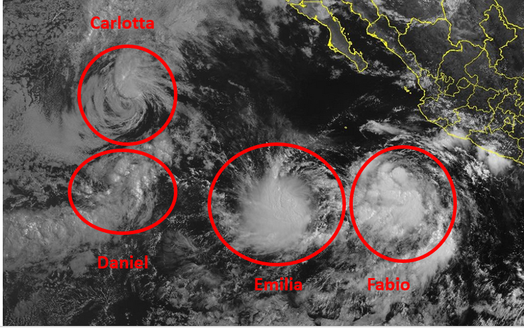
The circulations around Tropical Storms Emilia and Fabio were interacting on Tuesday afternoon.

At 5:00 p.m. EDT on Tuesday the center of Tropical Storm Emilia was located at latitude 14.4°N and longitude 115.3°W which put the center about 685 miles (1110 km) south-southwest of the southern tip of Baja California.  Emilia was moving toward the northwest at 3 m.p.h. (5 km/h).  The maximum sustained wind speed was 65 m.p.h. (105 km/h) and there were wind gusts to 80 m.p.h. (130 km/h).  The minimum surface pressure was 992 mb.

At 5:00 p.m. EDT on Tuesday the center of Tropical Storm Fabio was located at latitude 19.2°N and longitude 113.9°W which put the center about 625 miles (1010 km) west of Manzanillo, Mexico.  Fabio was moving toward the west-northwest at 21 m.p.h. (33 km/h).  The maximum sustained wind speed was 60 m.p.h. (95 km/h) and there were wind gusts to 75 m.p.h. (120 km/h).  The minimum surface pressure was 997 mb.

The circulations around Tropical Storm Emilia and Fabio were interacting on Tuesday afternoon.  Winds blowing around the southern side of Fabio’s circulation were interacting with winds that were blowing around the northern side of Tropical Storm Emilia.  The interactions were occurring in both the upper and lower troposphere.  The interactions were affecting the structures of both tropical storms.

Tropical Storm Emilia appeared to be the larger and more powerful of the two tropical storms.  Even so, the flow around the southern side of Fabio was having an effect on Emilia’s structure.  Most of the thunderstorms in Tropical Storm Emilia were occurring in bands in the southern half of Emilia’s circulation.  Bands in the northern side of Emilia consisted primarily of showers and low clouds.  Outflow from Tropical Storm Fabio was inhibiting upper level divergence to the north of Tropical Storm Emilia.

The interactions between the two tropical storms was also affecting the distribution of wind speeds in Tropical Storm Emilia.  Winds to tropical storm force extended out 140 miles (220 km) in the southern half of Emilia’s circulation.  Winds to tropical storm force only extended out 70 miles (110 km) in the northern side of Emilia.

The interaction with Tropical Storm Emilia appeared to be contributing to the start of a weakening trend in Tropical Storm Fabio.  The interaction with Emilia was also affecting the structure of Tropical Storm Fabio.  Most of the thunderstorms were occurring in bands in the eastern side of Fabio’s circulation.  Bands in the western part of Tropical Storm Fabio consisted primarily of showers and lower clouds.  Outflow from Tropical Storm Emilia was inhibiting upper level divergence to the south and west of Tropical Storm Fabio,

The interactions between the two tropical storms was also affecting the distribution of wind speeds in Tropical Storm Fabio.  Winds to tropical storm force extended out 100 miles (160 km) in the eastern side of Fabio’s circulation.  Winds to tropical storm force only extended out 35 miles (55 km) in the eastern half of Fabio.

It is possible that the larger circulation around Tropical Storm Emilia could absorb the smaller circulation of Tropical Storm Fabio.  The circulation around Fabio will continue to disrupt part of the circulation in the northern part of Tropical Storm Emilia.  Emilia may not intensify much during the interactions between the two storms.

Tropical Storm Emilia will move through an environment that is otherwise favorable for intensification during the next 24 hours.  Emilia will move move over water where the Sea Surface Temperatures are near 28°C.   It will move under an axis of an upper level ridge over the Eastern North Pacific Ocean.  The upper level winds are weak near the axis of the ridge.  There will be little vertical wind shear except for the shear caused by the outflow from Tropical Storm Fabio.  Tropical Storm Emilia is likely to intensify during the next 24 hours.  Emilia could strengthen to a hurricane.

Tropical Storm Emilia will move around the southern side of a high pressure system over the Eastern North Pacific Ocean.  The interaction with Tropical Storm Fabio is likely to pull Emilia toward the northwest during the next 24 hours.  On its anticipated track, Tropical Storm Emilia will move farther away from Baja California.  Emilia is likely to be steered toward the west-northwest by the high pressure system after it absorbs Tropical Storm Fabio.

Center of Tropical Storm Debby Near Savannah

The center of Tropical Storm Debby was near Savannah, Georgia on Tuesday morning.  At 11:00 a.m. EDT on Tuesday the center of Tropical Storm Debby was located at latitude 31.9°N and longitude 81.0°W which put the center about 15 miles (25 km) south of Savannah, Georgia.  Debby was moving toward the east-northeast at 6 m.p.h. (10 km/h).  The maximum sustained wind speed was 40 m.p.h. (65 km/h) and there were wind gusts to 50 m.p.h. (80 km/h).  The minimum surface pressure was 999 mb.

A Tropical Storm Warning was in effect for the portion of the coast from Altamaha Sound Georgia to Surf City, North Carolina.  The Tropical Storm Warning included Charleston, South Carolina.

A Tropical Storm Watch was in effect for the portion of the coast from Surf City to Beaufort Inlet, North Carolina.

Tropical Storm Debby continued to drop heavy rain over parts of South Carolina and eastern Georgia.  The airport at Charleston, South Carolina reported 8.11 inches (206 mm) of rain during the past 24 hours.  Valdosta, Georgia received 2.75 inches (70 mm) of rain.  Sarasota, Florida reported 11.06 inches (281 mm) of rain from Debby.  Gainesville, Florida received 6.80 inches (173 mm) of rain.  Jacksonville, Florida reported 4.70 inches (119 mm) of rain.  It is likely that higher rainfall totals occurred in some places where bands moved persistently over the same locations.

Southerly winds blowing around the eastern side of Tropical Storm Debby were pushing water toward the coast of South Carolina.  There were numerous reports of water in streets in Charleston, South Carolina.

Tropical Storm Debby weakened during the day it spent moving slowly across northern Florida and southeastern Georgia.  Drier air wrapped around the western and southern sides of Debby’s circulation.  Bands in the southwestern and southeastern quadrants of Tropical Storm Debby consisted primarily of showers and lower clouds.  Showers and thunderstorms were occurring in bands in the outer parts of the northeastern and northwestern quadrants of Tropical Storm Debby.  There were also showers and lower clouds near the center of Debby.

The distribution of wind speeds in Tropical Storm Debby was also asymmetrical.  Winds to tropical storm force extended out 205 miles (330 km) in the eastern side of Debby.  Those winds were occurring in bands in the outer parts of Debby’s circulation.  The winds in the parts of Debby’s circulation that were over land were blowing at less than tropical storm force.

Tropical Storm Debby will move into an environment favorable for intensification.  Debby will move over water where the Sea Surface Temperatures are near 29°C.  It will move under the middle of an upper level ridge over the southeastern U.S.  The upper level winds are weak near the center of the ridge and there will be little vertical wind shear.  The drier air in the southern part of Debby’s circulation will inhibit intensification.  Tropical Storm Debby is likely to intensify slowly during the next 24 hours.

Tropical Storm Debby will be in an area where the steering winds are weak during the next 24 hours.  Debby is likely to move slowly toward the east-northeast during the rest of Tuesday.  A high pressure system located east of Tropical Storm Debby is forecast to strengthen on Wednesday.  That high pressure system will steer Debby slowly toward the north on Wednesday.  On its anticipated track, the center of Tropical Storm Debby could approach the coast of South Carolina on Wednesday night.

Tropical Storm Debby will continue to drop heavy rain on parts of South Carolina, North Carolina and eastern Georgia.  Since Debby will move slowly, persistent heavy rain is likely to cause floods.

Flood Watches are in effect for parts of South Carolina, North Carolina and eastern Georgia.

Southerly winds blowing around the eastern side of Tropical Storm Debby will continue to push water toward the coast of South Carolina and North Carolina.  Debby could cause a storm surge of up to 6 feet (1.8 meters).

A Storm Surge Warning is in effect for the portion of the coast from Altamaha Sound, Georgia, to South Santee River, South Carolina.

A Storm Surge Watch is in effect for the portion of the coast from South Santee River, South Carolina to Cape Fear, North Carolina.

Tropical Storm Fabio Forms Southwest of Mexico

Tropical Storm Fabio formed over the Eastern North Pacific Ocean southwest of Mexico on Monday morning.  At 11:00 a.m. EDT on Monday the center of Tropical Storm Fabio was located at latitude 14.8°N and longitude 106.9°W which put the center about 335 miles (540 km) southwest of Manzanillo, Mexico.  Fabio was moving toward the northwest at 12 m.p.h. (19 km/h).  The maximum sustained wind speed was 40 m.p.h. (65 km/h) and there were wind gusts to 50 m.p.h. (80 km/h).  The minimum surface pressure was 1006 mb.

A low pressure system over the Eastern North Pacific Ocean southwest of Mexico strengthened on Monday morning and the U.S. National Hurricane Center designated the system as Tropical Storm Fabio.  More thunderstorms formed near the center of Fabio’s circulation.  However, the distribution of thunderstorms around Tropical Storm Fabio was asymmetrical.  Thunderstorms were occurring in bands in the southern and western parts of Fabio’s circulation.  Bands in the northern and eastern parts of Tropical Storm Fabio consisted primarily of showers and lower clouds.  Storms near the center of Fabio generated upper level divergence that pumped mass away to the west of the tropical storm.

Winds to tropical storm force extended out 70 miles in the southeastern quadrant of Tropical Storm Fabio.  The winds in the other parts of Fabio’s circulation were blowing at less than tropical storm force.

Tropical Storm Fabio will move through an environment somewhat favorable for intensification during the next 24 hours.  Fabio will move over water where the Sea Surface Temperatures are near 28°C.   It will move under the southern part of an upper level ridge over the Eastern North Pacific Ocean.  The ridge will produce easterly winds that will blow toward the top of Fabio’s circulation.  Those winds will cause some vertical wind shear, but the shear may not be enough to prevent intensification. The circulation around Fabio could interact with the circulation around Tropical Storm Emilia.  Tropical Storm Fabio could intensify during the next 24 hours.

Tropical Storm Fabio is currently being steered by the circulation around Tropical Storm Emilia.  Fabio is forecast to be steered toward the northwest during the next 24 hours.  On its anticipated track, Tropical Storm Fabio will move farther away from Mexico.  There is a chance that the circulations around Fabio and Tropical Storm Emilia could merge into a single circulation.

Elsewhere, Tropical Storms Carlotta, Daniel and Emilia were spinning over the Eastern North Pacific Ocean.

At 11:00 a.m. EDT on Monday the center of Tropical Storm Carlotta was located at latitude 20.4°N and longitude 127.2°W which put the center about 1125 miles (1805 km) west of the southern tip of Baja California.  Carlotta was moving toward the west at 9 m.p.h. (15 km/h).  The maximum sustained wind speed was 45 m.p.h. (75 km/h) and there were wind gusts to 60 m.p.h. (95 km/h).  The minimum surface pressure was 1001 mb.

At 11:00 a.m. EDT on Monday the center of Tropical Storm Daniel was located at latitude 15.6°N and longitude 127.7°W which put the center about 1265 miles (2035 km) west-southwest of the southern tip of Baja California.  Daniel was moving toward the northeast at 14 m.p.h. (22 km/h).  The maximum sustained wind speed was 40 m.p.h. (65 km/h) and there were wind gusts to 50 m.p.h. (80 km/h).  The minimum surface pressure was 1005 mb.

At 11:00 a.m. EDT on Monday the center of Tropical Storm Emilia was located at latitude 14.5°N and longitude 114.1°W which put the center about 640 miles (1035 km) west-southwest of the southern tip of Baja California.  Emilia was moving toward the south-southwest at 5 m.p.h. (8 km/h).  The maximum sustained wind speed was 45 m.p.h. (75 km/h) and there were wind gusts to 60 m.p.h. (120 km/h).  The minimum surface pressure was 1001 mb.


Hurricane Debby Moves Inland over North Florida

Hurricane Debby moved inland over North Florida on Monday morning.  At 8:00 a.m. EDT on Monday the center of Hurricane Debby was located at latitude 29.9°N and longitude 83.4°W which put the center about 20 miles (30 km) southeast of Perry, Florida.  Debby was moving toward the north-northeast at 10 m.p.h. (16 km/h).  The maximum sustained wind speed was 75 m.p.h. (120 km/h) and there were wind gusts to 90 m.p.h. (145 km/h).  The minimum surface pressure was 979 mb.

A Hurricane Warning was in effect for the portion of the coast from Yankeetown to Indian Pass, Florida.

A Tropical Storm Warning was in effect for the portion of the coast from Yankeetown to Boca Grande, Florida.  A Tropical Storm Warning was in effect for the portion of the coast from Indian Pass to Mexico Beach, Florida. A Tropical Storm Warning was in effect for the portion of the coast from St. Augustine, Florida to South Santee River, South Carolina.

The center of Hurricane Debby made landfall near Steinhatchee, Florida on Monday morning.  The maximum sustained wind speed in Hurricane Debby was 80 m.p.h. (130 km/h) at the time of landfall.  Thunderstorms were occurring in bands in the northern and eastern parts of Debby’s circulation.  Bands in the southern and western parts of Hurricane Debby consisted primarily of showers and lower clouds.

The distribution of winds speeds around Hurricane Debby was also asymmetrical at the time of landfall.  Winds to hurricane force extended out 25 miles (40 km) in the eastern side of Debby’s circulation.  Winds to tropical storm force extended out 140 miles (225 km) in the eastern half of Hurricane Debby.  Winds to tropical storm force extended out 70 miles in the western half of Debby’s circulation.

Hurricane Debby will move around the western end of a high pressure system over the western Atlantic Ocean.  The high pressure system and an upper level trough over the eastern U.S. will steer Debby toward the east-northeast during the next 24 hours.  On its anticipated track, Hurricane Debby will move across northeastern Florida and southeastern Georgia.  The steering currents could weaken during the  middle of the week and Debby could meander near the coast of South Carolina.

Hurricane Debby will weaken to a tropical storm as it moves inland over northeastern Florida and southeastern Georgia.  Debby will continue to produce strong winds and electricity outages are likely.  Hurricane Debby will drop heavy rain over northeastern Florida and southeastern Georgia.  Widespread flooding could occur.  If Debby stalls near South Carolina later this week, then prolonged heavy rain could occur.

Flood Watches are in effect for parts of Florida, Georgia and South Carolina.

Hurricane Debby will continue to cause a storm surge along the coast of west Florida while southwest winds blow water toward the coast.  The storm surge could be as high as 10 feet (3 meters) along parts of the coast.

A Storm Surge Warning is in effect for the portion of the coast from Longboat Key to Indian Pass, Florida.  A Storm Storm Warning is also in effect for the portion of the coast Mouth of the St. Mary’s River, Georgia to South Santee River, South Carolina.

Debby Strengthens to a Hurricane

Former Tropical Storm Debby strengthened to a hurricane over the northeastern Gulf of Mexico on Sunday night.  At 11:00 p.m. EDT on Sunday the center of Hurricane Debby was located at latitude 28.6°N and longitude 84.0°W which put the center about 65 miles (105 km) west-southwest of Cedar Key, Florida.  Debby was moving toward the north at 12 m.p.h. (19 km/h).  The maximum sustained wind speed was 75 m.p.h. (120 km/h) and there were wind gusts to 90 m.p.h. (145 km/h).  The minimum surface pressure was 985 mb.

A Hurricane Warning was in effect for the portion of the coast from Yankeetown to Indian Pass, Florida.

A Tropical Storm Warning was in effect for the portion of the coast from Yankeetown to Boca Grande, Florida.  A Tropical Storm Warning was in effect for the portion of the coast from Indian Pass to Mexico Beach, Florida. A Tropical Storm Warning was in effect for the portion of the coast from Ponte Vedre Beach, Florida to South Santee River, South Carolina.

Reconnaissance aircraft found hurricane force winds in the northeastern part of former Tropical Storm Debby on Sunday night.  The aircraft also found that the minimum surface pressure had decreased to 985 mb.  The inner end of a rainband wrapped around the center of Debby’s circulation several times.  However, drier air from the western side of Hurricane Debby caused breaks in the eyewall each time.  There was only a partial eyewall on the eastern side of Hurricane Debby on Sunday night.  There were only showers and lower clouds on the western side of of the center of Debby.  Thunderstorms were occurring in bands in the eastern side of Debby.  Bands in the western side of Debby consisted of primarily of showers and lower clouds.

The strongest winds were occurring in the eastern side of Hurricane Debby.  The winds were weaker in the western side of Debby’s circulation.  Hurricane force winds extended out 45 miles (75 km) in the northeastern quadrant of Hurricane Debby.  Winds to tropical storm force extended out 140 miles (225 km) from the center of Debby.

Hurricane Debby will move through an environment that will be only marginally favorable for intensification during the next few hours.  Debby will move over water where the Sea Surface Temperatures are near 30°C.  It will move under the eastern side of an upper level trough over the eastern U.S.  The trough will produce southeasterly winds that will blow toward the top of Debby’s circulation.  Those winds will cause some vertical wind shear.  Hurricane Debby will also pull more drier air around the western side of its circulation.  The wind shear and dry air are likely to prevent intensification during the next few hours.

Hurricane Debby will move around the western end of a high pressure system over the western Atlantic Ocean.  The high pressure system and the upper level trough over the eastern U.S. will steer Debby toward the north-northeast during the next 24 hours.  On its anticipated track, Hurricane Debby will make landfall in Apalachee Bay on Monday morning.

Hurricane Debby will bring strong winds and heavy rain to part of north Florida.  Heavy rain could cause flooding in some locations.

Flood Watches were in effect for parts of Florida, Georgia and South Carolina.

Hurricane Debby could also cause a storm surge of up to 10 feet (3 meters) along the west coast of Florida.

A Storm Surge Warning is in effect for the portion of the coast from Longboat Key to Indian Pass, Florida.  A Storm Storm Warning is also in effect for the portion of the coast Mouth of the St. Mary’s River, Georgia to South Santee River, South Carolina.

A Storm Surge Watch is in effect for the portion of the coast from Englewood to Longboat Key.  The Storm Surge Watch includes Charlotte Harbor.

Carlotta Weakens to a Tropical Storm

Former Hurricane Carlotta weakened to a tropical storm over the Eastern North Pacific Ocean west of Baja California on Sunday.  At 5:00 p.m. EDT on Sunday the center of Tropical Storm Carlotta was located at latitude 19.9°N and longitude 125.0°W which put the center about 990 miles (1595 km) west of the southern tip of Baja California.  Carlotta was moving toward the west at 10 m.p.h. (16 km/h).  The maximum sustained wind speed was 60 m.p.h. (95 km/h) and there were wind gusts to 75 m.p.h. (120 km/h).  The minimum surface pressure was 998 mb.

Former Hurricane Carlotta weakened to a tropical storm on Sunday when it moved over cooler water in the Eastern North Pacific Ocean west of Baja California.  Many of the thunderstorms in Tropical Storm Carlotta weakened or dissipated on Sunday.  Even though the circulation around Carlotta weakened, it still appeared well organized in visible satellite images.  Numerous bands of showers, and low and middle clouds were revolving around the center of Carlotta’s circulation.  However, the showers near the center of Carlotta were too shallow to generate upper level divergence that could pump mass away from the tropical storm.  Thus, convergence of mass in the lower levels of the atmosphere caused the surface pressure to increase.

Tropical Storm Carlotta will move through an environment that will be unfavorable for intensification during the next 24 hours.  Carlotta will move over water where the Sea Surface Temperatures are near 25°C.  It will move near the axis of an upper level ridge over the Eastern North Pacific Ocean.  The upper level winds are weak near the axis of the ridge and there will be little vertical wind shear.  Tropical Storm Carlotta is likely to continue to weaken slowly as it moves over the cool water.

Tropical Storm Carlotta will move around the southern side of a high pressure system over the Eastern North Pacific Ocean.  The high pressure system will steer Carlotta toward the west during the next 24 hours.  On its anticipated track, Tropical Storm Carlotta will move farther away from Baja California.

Elsewhere over the Eastern North Pacific Ocean, Tropical Storm Daniel meandered west of Tropical Storm Carlotta and Tropical Depression Five-E formed south of Baja California.

At 5:00 p.m. EDT on Sunday the center of Tropical Storm Daniel was located at latitude 13.4°N and longitude 129.9°W which put the center about 1465 miles (2355 km) west-southwest of the southern tip of Baja California.  Daniel was moving toward the northeast at 8 m.p.h. (13 km/h).  The maximum sustained wind speed was 40 m.p.h. (65 km/h) and there were wind gusts to 50 m.p.h. (80 km/h).  The minimum surface pressure was 1006 mb.

At 5:00 p.m. EDT on Sunday the center of Tropical Depression Five-E was located at latitude 15.5°N and longitude 113.2°W which put the center about 555 miles (890 km) south-southwest of the southern tip of Baja California.  The tropical depression was moving toward the south at 2 m.p.h. (3 km/h).  The maximum sustained wind speed was 35 m.p.h. (55 km/h) and there were wind gusts to 45 m.p.h. (75 km/h).   The minimum surface pressure was 1007 mb.

Tropical Storm Debby Strengthens

Tropical Storm Debby strengthened over the eastern Gulf of Mexico on Sunday morning.  At 8:00 a.m. EDT on Sunday the center of Tropical Storm Debby was located at latitude 26.3°N and longitude 84.2°W which put the center about 155 miles (255 km) southwest of Tampa, Florida.  Debby was moving toward the north-northwest at 13 m.p.h. (20 km/h).  The maximum sustained wind speed was 60 m.p.h. (95 km/h) and there were wind gusts to 75 m.p.h. (120 km/h).  The minimum surface pressure was 1001 mb.

A Hurricane Warning was in effect for the portion of the coast from Suwannee River to Ochlockonee River, Florida.

A Hurricane Watch was in effect for the portion of the coast from Ochlockonee River to Indian Pass, Florida.  A Hurricane Watch was in effect for the portion of the coast from Suwannee River to Yankeetown, Florida.

A Tropical Storm Warning was in effect for the portion of the coast from East Cape Sable to Suwannee River, Florida.  A Tropical Storm Warning was in effect for the Florida Keys west of Seven Mile Bridge.  A Tropical Storm Warning was in effect for the Dry Tortugas.  A Tropical Storm Warning was in effect for the portion of the coast from Ochlockonee River to Indian Pass, Florida.

A Tropical Storm Watch was in effect for the Florida Keys from Seven Mile Bridge to Channel 5 Bridge,  A Tropical Storm Watch was in effect for portion of the coast from Indian Pass to Mexico Beach, Florida.  A Tropical Storm Watch was in effect for the portion of the coast from the Mouth of the St. Mary’s River, Georgia to the South Santee River, South Carolina.

Tropical Storm Debby strengthened over the eastern Gulf of Mexico on Sunday morning.  Thunderstorms were occurring near the center of Debby’s circulation.  Thunderstorms were also occurring in bands in the eastern side of Tropical Storm Debby.  Bands in the western side of Debby consisted primarily of showers and lower clouds.  Storms near the center of Debby’s circulation generated upper level divergence that pumped mass away to the east of the tropical storm.

The distribution of winds in Tropical Storm Debby continued to be asymmetrical.  Winds to tropical storm force extended out 140 miles (225 km) in the eastern half of Debby’s circulation.  Winds in the western side of Debby were blowing at less than tropical storm force.

Tropical Storm Debby will move through an environment favorable for intensification during the next 24 hours.  Debby will move over water where the Sea Surface Temperatures are near 30°C.  It will move under the eastern side of an upper level trough over the eastern U.S.  The trough will produce southeasterly winds that will blow toward the top of Debby’s circulation.  Those winds will cause some vertical wind shear, but the wind shear will not be enough to prevent intensification.  Tropical Storm Debby will intensify during the next 24 hours.  Debby is likely to intensify to a hurricane by Sunday night.

Tropical Storm Debby will move around the western end of a high pressure system over the western Atlantic Ocean.  The high pressure system will steer Debby toward the north during the next 24 hours.  On its anticipated track, Tropical Storm Debby will approach the coast of north Florida by Monday morning.

Tropical Storm Debby is likely to be a hurricane when it approaches the north coast of Florida.  Debby will bring strong winds and locally heavy rain to Florida.  Heavy rain could cause flooding in some locations.  Tropical Storm Debby could also cause a storm surge of up to 10 feet (3 meters) along the west coast of Florida.

A Storm Surge Warning is in effect for the portion of the coast from Aripeka to Indian Pass, Florida.

A Storm Surge Watch is in effect for the portion of the coast from Bonita Beach to Aripeka, Florida.  The Storm Surge Watch includes Tampa Bay and Charlotte Harbor.  A Storm Surge Watch is in effect for the portion of the coast from the Mouth of the St. Mary’s River, Georgia to South Santee River, South Carolina.

Hurricane Carlotta Churns West

Hurricane Carlotta churned toward the west over the Eastern North Pacific Ocean on Saturday.  At 11:00 p.m. EDT on Saturday the center of Hurricane Carlotta was located at latitude 19.4°N and longitude 121.9°W which put the center about 810 miles (1300 km) west-southwest of the southern tip of Baja California.  Carlotta was moving toward the west-northwest at 10 m.p.h. (16 km/h).  The maximum sustained wind speed was 80 m.p.h. (130 km/h) and there were wind gusts to 95 m.p.h. (150 km/h).  The minimum surface pressure was 985 mb.

Hurricane Carlotta started to weaken slowly on Saturday night when it moved over cooler water.  Thunderstorms in Hurricane Carlotta did not rise as high into the atmosphere.  Even though Carlotta started to weaken, its circulation was well organized.  A small circular eye was still present at the center of Hurricane Carlotta.  The eye was surrounded by a ring of thunderstorms and the strongest winds were occurring in that ring of storms.  Bands of showers and thunderstorms were revolving around the core of Carlotta’s circulation.  Storms near the core of Carlotta still generated upper level divergence that pumped mass away from the hurricane.

The circulation around Hurricane Carlotta was small.  Winds to hurricane force extended out 25 miles (40 km) from the center of Carlotta’s circulation.  Winds to tropical storm force extended out 90 miles (145 km) from the center of Hurricane Carlotta.

Hurricane Carlotta will move through an environment that will be unfavorable for intensification during the next 24 hours.  Carlotta will move over water where the Sea Surface Temperatures are near 25°C.  It will move near the axis of an upper level ridge over the Eastern North Pacific Ocean.  The upper level winds are weak near the axis of the ridge and there will be little vertical wind shear.  Hurricane Carlotta is likely to continue to weaken slowly as it moves over even cooler water.

Hurricane Carlotta will move around the southern side of a high pressure system over the Eastern North Pacific Ocean.  The high pressure system will steer Carlotta toward the west during the next 24 hours.  On its anticipated track, Hurricane Carlotta will move farther away from Baja California.

Elsewhere over the Eastern North Pacific Ocean, Tropical Storm Daniel formed west of Hurricane Carlotta.  At 11:00 p.m. EDT on Saturday the center of Tropical Storm Daniel was located at latitude 12.3°N and longitude 130.5°W which put the center about 1540 miles (2475 km) west-southwest of the southern tip of Baja California.  Daniel was moving toward the north at 2 m.p.h. (3 km/h).  The maximum sustained wind speed was 40 m.p.h. (65 km/h) and there were wind gusts to 50 m.p.h. (80 km/h).  The minimum surface pressure was 1006 mb.

Tropical Storm Debby Forms North of Cuba

Tropical Storm Debby formed north of Cuba on Saturday afternoon.  At 5:00 p.m. EDT on Saturday the center of Tropical Storm Debby was located at latitude 23.4°N and longitude 83.2°W which put the center about 100 miles (160 km) west-southwest of Key West, Florida. Debby was moving toward the northwest at 15 m.p.h. (24 km/h).  The maximum sustained wind speed was 40 m.p.h. (65 km/h) and there were wind gusts to 50 m.p.h. (80 km/h).  The minimum surface pressure was 1007 mb.

A Hurricane Warning was in effect for the portion of the coast from Suwannee River to Ochlockonee River, Florida.

A Hurricane Watch was in effect for the portion of the coast from Ochlockonee River to Indian Pass, Florida.  A Hurricane Watch was in effect for the portion of the coast from Suwannee River to Yankeetown, Florida.

A Tropical Storm Warning was in effect for the portion of the coast from East Cape Sable to Suwannee River, Florida.  A Tropical Storm Warning was in effect for the Florida Keys west of Seven Mile Bridge.  A Tropical Storm Warning was in effect for the Dry Tortugas.

A Tropical Storm Watch was in effect for the Florida Keys from Seven Mile Bridge to Channel 5 Bridge,  A Tropical Storm Watch was in effect for portion of the coast from Indian Pass to Mexico Beach, Florida.

Former Tropical Depression Four strengthened on Saturday afternoon and the U.S. National Hurricane Center designated the system as Tropical Storm Debby.  More thunderstorms formed near the center of Tropical Storm Debby after it moved north of Cuba.  More thunderstorms also formed in bands revolving around the center of Tropical Storm Debby.  Storm’s near the center of Debby’s circulation generated more upper level divergence that pumped mass away from the tropical storm.

The distribution of wind speeds in Tropical Storm Debby was asymmetrical.  Winds to tropical storm force extended out 140 miles (225 km) in the eastern half of Debby’s circulation.  Winds in the western side of Debby were blowing at less than tropical storm force.

Tropical Storm Debby Four will move through an environment favorable for intensification during the next 24 hours.  Debby will move over water where the Sea Surface Temperatures are near 30°C.  It will move under the southeastern part of an upper level ridge over the southeastern U.S.  The ridge will produce northeasterly winds that will blow toward the top of Debby’s circulation.  The winds in the lower levels of the atmosphere will also blow from the east and there will be little vertical wind shear.  Tropical Storm Debby will intensify during the next 24 hours.  Debby is likely to intensify slowly as it moves away from Cuba.  Tropical Storm Debby is likely to intensify more rapidly when it moves over the eastern Gulf of Mexico on Sunday.  Debby could strengthen to a hurricane over the Gulf of Mexico.

Tropical Storm Debby will move around the western end of a high pressure system over the western Atlantic Ocean.  The high pressure system will steer Debby toward the north-northwest during the next 24 hours.  On its anticipated track, Tropical Storm Debby will approach the coast of north Florida on Monday.

Tropical Storm Debby will bring strong winds and locally heavy rain to Florida.  Heavy rain could cause flooding in some locations.  Tropical Storm Debby could also cause a storm surge of up to 8 feet (2.3 meters) along the west coast of Florida.

A Storm Surge Warning is in effect for the portion of the coast from Aripeka to Indian Pass, Florida.

A Storm Surge Watch is in effect for the portion of the coast from Bonita Beach to Aripeka, Florida.  The Storm Surge Watch includes Tampa Bay and Charlotte Harbor. 

Tropical Depression Four Forms South of Cuba

Tropical Depression Four formed south of Cuba on Friday night.  At 11:00 p.m. EDT on Friday the center of Tropical Depression Four was located at latitude 21.4°N and longitude 79.7°W which put the center about 75 miles (120 km) south of Caibarien, Cuba and about 260 miles (415 km) south-southeast of Key West, Florida.  Tropical Depression Four was moving toward the west-northwest at 17 m.p.h. (28 km/h).   The maximum sustained wind speed was 30 m.p.h. (50 km/h) and there were wind gusts to 40 m.p.h. (65 km/h).  The minimum surface pressure was 1010 mb.

A Tropical Storm Warning was in effect for the portion of the coast from East Cape Sable to Boca Grande, Florida.  A Tropical Storm Warning was in effect for the Dry Tortugas.

A Tropical Storm Watch was in effect for the Florida Keys from south of Card Sound Bridge.  A Tropical Storm Watch was in effect for the portion of the coast from East Cape Sable to Card Sound Bridge, Florida.  A Tropical Storm Watch was in effect for the portion of the coast from Boca Grande to the mouth of the Suwannee River, Florida.

A distinct low level center of circulation developed over the Caribbean Sea south of Cuba in a tropical wave previously designated as Potential Tropical Cyclone Four, and the U.S. National Hurricane Center designated the system as Tropical Depression Four.  More thunderstorms formed near the center of Tropical Depression Four on Friday night.  Thunderstorms also developed in bands revolving around the center of Tropical Depression Four.  Storms near the center of circulation began to generate upper level divergence that pumped mass away from the tropical depression.

Tropical Depression Four will move through an environment favorable for the formation of a tropical cyclone during the next 24 hours.  Tropical Depression Four will move over water where the Sea Surface Temperatures are near 30°C.  It will move under the southeastern part of an upper level ridge over the southeastern U.S.  The ridge will produce northeasterly winds that will blow toward the top of the tropical depression.  The winds in the lower levels of the atmosphere will also blow from the east and there will be little vertical wind shear.  Tropical Depression Four is likely to intensify slowly as long as the center of the depression is near Cuba. The tropical depression is likely to intensify more rapidly when it reaches the Gulf of Mexico.

Tropical Depression Four will moving around the southwestern part of a high pressure system over the western Atlantic Ocean.  The high pressure system will steer Tropical Depression Four toward the west-northwest during the next 24 hours.  On its anticipated track, Tropical Depression Four will move across western Cuba and into the Gulf of Mexico.  The tropical depression is likely to move toward the north during the weekend when it reaches the western end of the high pressure system.

Tropical Depression Four is likely to bring gusty winds and locally heavy rain to Florida during the weekend.  Heavy rain could cause widespread flooding.  Tropical Depression Four could also cause a storm surge along the west coast of Florida.

A Storm Surge Watch is in effect for the portion of the coast from Bonita Beach to the Mouth of the Suwannee River, Florida.  The Storm Surge Watch includes Tampa Bay and Charlotte Harbor.