
Tag Archives: Texas

Tropical Storm Warning Issued for Louisiana

The potential risk posed by a low pressure system near Corpus Christi, Texas prompted the U.S. National Hurricane Center to issue a Tropical Storm Warning for a portion of the coast of Louisiana on Tuesday afternoon.  The National Hurricane Center has designated the low pressure system as Potential Tropical Cyclone One.  At 8:00 p.m. EDT on Tuesday the center of Potential Tropical Cyclone One was located at latitude 27.6°N and longitude 97.3°W which put the center about 15 miles (25 km) south-southeast of Corpus Christi, Texas.  The low pressure system was moving toward the northeast at 6 m.p.h. (10 km/h).  The maximum sustained wind speed was 30 m.p.h. (50 km/h) and there were wind gusts to 40 m.p.h. (65 km/h).  The minimum surface pressure was 1004 mb.

A Tropical Storm Warning is in effect for the portion of the coast from Sabine Pass to Morgan City, Louisiana.

A Tropical Storm Watch is in effect for the portion of the coast from Sargent, Texas to Sabine Pass, Louisiana.

The National Hurricane Center designated a low pressure system over South Texas as Potential Tropical Cyclone One on Tuesday. The distribution of thunderstorms in Potential Tropical Cyclone One was still asymmetrical on Tuesday evening. Thunderstorms were occurring in bands in the eastern side of the low pressure system. The strongest thunderstorms were occurring in bands that were over the Gulf of Mexico. Bands in the western half of the low pressure system consisted primarily of showers and lower clouds. Storms near the center of circulation generated upper level divergence that pumped mass away from the low pressure system. The removal of mass caused the surface pressure to slowly decrease.

Potential Tropical Cyclone One will move around the northwestern side of a high pressure system that extends from the western Atlantic Ocean to over the Gulf of Mexico.  The high pressure system will steer the low pressure system toward the northeast during the next 24 hours . On its anticipated track, the low pressure system could move over the northwestern Gulf of Mexico.

If Potential Tropical Cyclone One moves over the northwestern Gulf of Mexico, it will move into an environment that will be marginally favorable for the development of a tropical storm.  The low pressure system will move over water where the Sea Surface Temperatures are near 28°C.  It will move under the southern part of an upper level trough that is over the eastern U.S.  The upper level trough will produce westerly winds that will blow toward the top of Potential Tropical Cyclone One.  Those winds will cause moderate vertical wind shear.  The vertical wind shear will inhibit development, but the wind shear may not be enough to prevent the formation of a tropical depression or a tropical storm.

The U.S. National Hurricane Center is indicating that the probability is 70% that a tropical depression or a tropical storm forms over the northwestern Gulf of Mexico. Reconnaissance planes have been tentatively tasked to fly into the the low pressure system on Wednesday, if necessary.

The low pressure system has already dropped heavy rain over parts of South Texas and northern Mexico.

Flood Watches are in effect for South Texas, southeast Texas, most of Louisiana, the southern half of Mississippi, central Alabama, Northwest Florida, and northern Georgia.
Tropical Storm Watch Issued for Texas and Louisiana

The potential risk posed by a low pressure system over South Texas prompted the U.S. National Hurricane Center to issue a Tropical Storm Watch for a portion of the coast of Texas and Louisiana on Tuesday.  The National Hurricane Center also designated the low pressure system as Potential Tropical Cyclone One.  At 2:00 p.m. EDT on Tuesday the center of Potential Tropical Cyclone One was located at latitude 27.19°N and longitude 97.8°W which put the center about 55 miles (90 km) southwest of Corpus Christi, Texas.  The low pressure system was moving toward the northeast at 6 m.p.h. (10 km/h).  The maximum sustained wind speed was 30 m.p.h. (50 km/h) and there were wind gusts to 40 m.p.h. (65 km/h).  The minimum surface pressure was 1006 mb.

A Tropical Storm Watch is in effect for the portion of the coast from Sargent, Texas to Morgan City, Louisiana.

The National Hurricane Center designated a low pressure system over South Texas as Potential Tropical Cyclone One on Tuesday.  The distribution of thunderstorms in Potential Tropical Cyclone One was asymmetrical.  Thunderstorms were occurring in bands in the eastern side of the low pressure system.  The strongest thunderstorms were occurring in bands that were over the Gulf of Mexico.  Bands in the western half of the low pressure system consisted primarily of showers and lower clouds.  Storms near the center of circulation generated upper level divergence that pumped mass away from the low pressure system.  The removal of mass caused the surface pressure to slowly decrease.

Potential Tropical Cyclone One will move around the northwestern side of a high pressure system that extends from the western Atlantic Ocean to over the Gulf of Mexico.  The high pressure system will steer the low pressure system toward the northeast during the next 24 hours.   On its anticipated track, the low pressure system could move over the northwestern Gulf of Mexico.

If Potential Tropical Cyclone One moves over the northwestern Gulf of Mexico, it will move into an environment that will be marginally favorable for the development of a tropical storm.  The low pressure system will move over water where the Sea Surface Temperatures are near 28°C.  It will move under the southern part of an upper level trough that is over the eastern U.S.  The upper level trough will produce westerly winds that will blow toward the top of Potential Tropical Cyclone One.  Those winds will cause moderate vertical wind shear.  The vertical wind shear will inhibit development, but the wind shear may not be enough to prevent the formation of a tropical depression or a tropical storm.

The U.S. National Hurricane Center is indicating that the probability is 70% that a tropical depression or a tropical storm forms over the northwestern Gulf of Mexico.  Reconnaissance planes have been tentatively tasked to fly into the the low pressure system on Tuesday night and Wednesday, if necessary.

The low pressure system has already dropped heavy rain over parts of South Texas and northern Mexico.

Flood Watches are in effect for South Texas, southeast Texas, most of Louisiana, and the southern half of Mississippi.

Low Pressure over South Texas

A low pressure system formed over South Texas on Monday evening.  The low pressure system was designated as Invest 90L by the U.S. National Weather Service.  At 2:00 a.m. EDT on Tuesday the center of a low pressure system was located at latitude 26.9°N and longitude 99.3°W which put the center about 35 miles (55 km) south-southeast of Laredo, Texas.  The low pressure system was moving toward the northeast at 8 m.p.h. (13 km/h).  The maximum sustained wind speed was 25 m.p.h. (35 km/h) and there were wind gusts to 35 m.p.h. (55 km/h).  The minimum surface pressure was 1009 mb.

An upper level low interacting with the northern end of a tropical wave caused a surface low pressure system to form over South Texas on Monday evening.  The low pressure system was evident on surface weather maps which showed a weak counterclockwise rotation over southern Texas.  Thunderstorms were occurring in bands in the eastern side of the low pressure system.  Bands in the western and southern parts of the low pressure system consisted primarily of showers and lower clouds.

The low pressure system will move around the northwestern side of a high pressure system that extends from the western Atlantic Ocean to over the Gulf of Mexico.  The high pressure system will steer the low pressure system toward the northeast during the next 24 hours.  On its anticipated track, the low pressure system could move over the northwestern Gulf of Mexico.

If the low pressure system moves over the northwestern Gulf of Mexico, it will move into an environment that will be marginally favorable for the development of a tropical storm.  The low pressure system will move over water where the Sea Surface Temperatures are near 28°C.  It will move under the southern part of an upper level trough that is over the eastern U.S.  The upper level trough will produce westerly winds that will blow toward the top of the low pressure system.  Those winds will cause moderate vertical wind shear.  The vertical wind shear will inhibit development, but the wind shear may not be enough to prevent the formation of a tropical depression or a tropical storm.

The U.S. National Hurricane Center is indicating that the probability is 60% that a tropical storm forms over the northwestern Gulf of Mexico.  Reconnaissance planes have been tentatively tasked to fly into the the low pressure system on Tuesday night and Wednesday, if necessary.

The low pressure system has already dropped heavy rain over parts of South Texas and northern Mexico.

Flood Watches are in effect for South Texas, southeast Texas, most of Louisiana, and southern Mississippi.


Tropical Storm Francine Churns over Western Gulf of Mexico

Tropical Storm Francine was churning over the western Gulf of Mexico on Tuesday morning.  At 8:00 a.m. EDT on Tuesday the center of Tropical Storm Francine located at latitude 24.5°N and longitude 94.9°W which put the center about 395 miles (640 km) south-southwest of Cameron, Louisiana.  Francine was moving toward the north at 5 m.p.h. (8 km/h).  The maximum sustained wind speed was 65 m.p.h. (105 km/h) and there were wind gusts to 80 m.p.h. (130 km/h).  The minimum surface pressure was 990 mb.

A Hurricane Warning is in effect for the portion of the coast from Sabine Pass to Grand Isle. Louisiana.

A Tropical Storm Warning is in effect for the portion of the coast from Grand Isle, Louisiana to the Mouth of the Pearl River.  The Tropical Storm Warning includes New Orleans.  The Tropical Storm Warning also includes Lake Pontchartrain and Lake Maurepas.  A Tropical Storm Warning is in effect for the portion of the coast from High Island, Texas to Sabine Pass, Louisiana.  A Tropical Storm Warning is in effect for the portion of the coast from Port Mansfield, Texas to the Mouth of the Rio Grande River.  A Tropical Storm Warning is in effect for the portion of the coast from La Pesca, Mexico to the Mouth of the Rio Grande River.

A Tropical Storm Watch is in effect for the portion of the coast from High Island to Port Mansfield, Texas.  A Tropical Storm Watch is in effect for the portion of the coast from Barra del Tordo to La Pesca, Mexico.

Rainbands in the western side of Tropical Storm Francine were dropping heavy rain on parts of south Texas.  A Flash Flood Warning is in effect for the area around Brownsville, Texas.

The circulation around Tropical Storm Francine showed signs of developing an inner core on Tuesday morning.  The inner end of a rainband wrapped most of the way around the center of Francines’s circulation.  An eye with a diameter of 25 miles (40 km) appeared to be forming at the center of Tropical Storm Francine.  The eye was surrounded by a nearly complete ring of thunderstorms and the strongest winds were occurring in that ring of storms.  Thunderstorms were occurring in bands in the northeastern part of Francine’s circulation.  Thunderstorms were also occurring in bands in the western side of Tropical Storm Francine.

The size of the circulation around Tropical Storm Francine contracted a little as it began to resemble a typical tropical cyclone.  Winds to tropical storm force extended out 140 miles (220 km) from the center of Francine’s circulation.

Tropical Storm Francine will move through an environment very favorable for intensification during the next 24 hours.  Francine will move over water where the Sea Surface Temperatures are near 30°C.  It will move under the middle of an upper level ridge over the western Gulf of Mexico.  The upper level winds are weak near the middle of the ridge and there will be little vertical wind shear.  Tropical Storm Francine will intensify to a hurricane during the next 24 hours.  Francine could intensify rapidly after the inner core is fully formed.

Tropical Storm Francine will move around the western part of a high pressure system that extends from the western Atlantic Ocean to the Gulf of Mexico.  The high pressure system will steer Francine toward the northeast during the next 24 hours.  On its anticipated track, Tropical Storm Francine will move toward Louisiana.  Francine will move faster toward the northeast on Wednesday when an upper level trough over the south central U.S. also begins to steer it toward the coast.  Tropical Storm Francine will approach the coast of Louisiana on Wednesday afternoon.  Francine will be a hurricane when it approaches the coast of Louisiana.

Tropical Storm Francine will bring strong winds and heavy rain to Louisiana.  Francine will be capable of causing serious damage.  Widespread outages of electricity are likely.  Heavy rain is likely to cause flash floods.

Flood Watches are in effect for parts of Louisiana.

Tropical Storm Francine could cause a storm surge of up to 10 feet (3 meters) along parts of the coast of Louisiana.

A Storm Surge Warning is in effect for the portion of the coast from High Island, Texas to the Mouth of the Mississippi River.  The Storm Surge Warning includes Vermilion Bay.


Tropical Storm Francine Prompts Hurricane Watch for Louisiana

The risk posed by Tropical Storm Francine prompted the issuance of a Hurricane Watch for a portion of the coast of Louisiana on Monday morning.  At 11:00 a.m. EDT on Monday the center of Tropical Storm Francine located at latitude 23.0°N and longitude 94.9°W which put the center about 480 miles (770 km) south-southwest of Cameron, Louisiana.  Francine was moving toward the north-northwest at 5 m.p.h. (8 km/h).  The maximum sustained wind speed was 50 m.p.h. (80 km/h) and there were wind gusts to 60 m.p.h. (95 km/h).  The minimum surface pressure was 1002 mb.

A Hurricane Watch is in effect for the portion of the coast from Cameron to Grand Isle, Louisiana.

A Tropical Storm Watch is in effect for the portion of the coast from Grand Isle, Louisiana to the Mississippi/Alabama border.  The Tropical Storm Watch includes New Orleans.  The Tropical Storm Watch also includes Lake Pontchartrain and Lake Maurepas.  A Tropical Storm Watch is in effect for the portion of the coast from High Island, Texas to Cameron, Louisiana.  A Tropical Storm Watch is in effect for the portion of the coast from Port Mansfield, Texas to the Mouth of the Rio Grande River.  A Tropical Storm Watch is in effect for the portion of the coast from Barra del Tordo, Mexico to the Mouth of the Rio Grande River.

A U.S. Air Force Reserve Hurricane Hunter plane investigated a low pressure system over the western Gulf of Mexico previously designated as Potential Tropical Cyclone Six on Monday morning.  The crew of the aircraft found that the circulation around the low pressure system was more organized.  Based on the data from the aircraft, the U.S. National Hurricane Center determined that former Potential Tropical Cyclone Six had developed the characteristics of a tropical storm.  The National Hurricane Center designated former Potential Tropical Cyclone Six as Tropical Storm Francine.

A distinct low level center of circulation formed at the center of Tropical Storm Francine.  Thunderstorms had formed near the center of Francine’s circulation.  More thunderstorms also developed in bands revolving around the center of Tropical Storm Francine.  Storms near the center of Francine generated upper level divergence that pumped mass away from the tropical storm.

The circulation around Tropical Storm Francine was more symmetrical on Monday morning.  Winds to tropical storm force extended out 160 miles (260 km) from the center of Francine’s circulation.

Tropical Storm Francine will move through an environment very favorable for intensification during the next 24 hours.  Francine will move over water where the Sea Surface Temperatures are near 30°C.  It will move under the middle of an upper level ridge over the western Gulf of Mexico.  The upper level winds are weak near the middle of the ridge and there will be little vertical wind shear.  Tropical Storm Francine is likely to intensify gradually during the next few hours while an inner core develops.  Francine could intensify rapidly on Tuesday after an inner core forms.  Tropical Storm Francine is likely to strengthen to a hurricane on Tuesday.

Tropical Storm Francine will move around the western part of a high pressure system that extends from the western Atlantic Ocean to the Gulf of Mexico.  The high pressure system will steer Francine toward the north during the next 24 hours.  On its anticipated track, Tropical Storm Francine will move toward Louisiana.  Francine will move more toward the northeast on Wednesday when an upper level trough over the south central U.S. begins to steer it toward the coast.  Tropical Storm Francine will approach the coast of Louisiana on Wednesday afternoon.  Francine is likely to be a hurricane when it approaches the coast of Louisiana.

Tropical Storm Francine will bring strong winds and heavy rain to Louisiana.  Francine will be capable of causing serious damage.  Heavy rain is likely to cause flash floods.

Flood Watches are in effect for parts of Louisiana.

Tropical Storm Francine could cause a storm surge of up to 10 feet (3 meters) along parts of the coast of Louisiana.

A Storm Surge Watch is in effect for the portion of the coast from High Island, Texas to the Mouth of the Pearl River.  The Storm Surge Watch includes, Vermillion Bay, Lake Pontchartrain and Lake Maurepas.


Low Pressure System over Gulf of Mexico Designated Potential Tropical Cyclone Six

A low pressure system over the southwestern Gulf of Mexico was designated as Potential Tropical Cyclone Six by the U.S. National Hurricane Center on Sunday afternoon.  A Tropical Storm Watch was issued for the coast of northern Mexico.  At 5:00 p.m. EDT on Sunday the center of Potential Tropical Cyclone Six located at latitude 21.6°N and longitude 94.6°W which put the center about 340 miles (545 km) south-southeast of the Mouth of the Rio Grande River.  The low pressure system was moving toward the northwest at 5 m.p.h. (8 km/h).  The maximum sustained wind speed was 50 m.p.h. (80 km/h) and there were wind gusts to 60 m.p.h. (95 km/h).  The minimum surface pressure was 1003 mb.

A Tropical Storm Watch was in effect for the portion of the coast from Barra del Tordo,, Mexico to the Mouth of the Rio Grande River.

A U.S. Air Force Reserve Hurricane Hunter reconnaissance aircraft investigated a low pressure system over the southwest Gulf of Mexico that was previously designated as Invest 91L on Sunday afternoon.  The Hurricane Hunters found that there was a large low pressure system with a broad counterclockwise rotation.  The reconnaissance flight was unable to find a distinct low level center of circulation.  The flight crew did find a large area of tropical storm force winds in the western side of the low pressure system.

Winds to tropical storm force extended out 185 miles (295 km) in the western side of Potential Tropical Cyclone Six.  The winds in the eastern side of the low pressure system were blowing at less than tropical storm force.

The strongest winds in Potential Tropical Cyclone Six were occurring in bands of thunderstorms in the southwestern part of the low pressure system.  The bands in the other parts of the circulation consisted primarily of showers and lower clouds.  The storms in the southwestern part of Potential Tropical Cyclone Six began to generate upper level divergence that pumped mass away from the low pressure system.

Potential Tropical Cyclone Six will move through an environment mostly favorable for the intensification during the next 24 hours.  The low pressure system will move over water where the Sea Surface Temperatures are near 30°C.  It will move over the eastern part of an upper level ridge over northern Mexico and the western Gulf of Mexico.  The upper level ridge will produce northwesterly winds that will blow toward the top of Potential Tropical Cyclone Six’s circulation.  Those winds will cause some vertical wind shear.  The wind shear will inhibit intensification, but the shear will not be enough to prevent intensification.  The large size of the circulation around the low pressure system will also reduce the rate of intensification.  Potential Tropical Cyclone Six is likely to intensify slowly during the next 24 hours.  The low pressure system could intensify more rapidly after an inner core forms.

Potential Tropical Cyclone Six will move around the southwestern part of a high pressure system that extends from the western Atlantic Ocean to the Gulf of Mexico.  The high pressure system will steer the low pressure system toward the northwest during the next 24 hours.  On its anticipated track, Potential Tropical Cyclone Six will move toward northern Mexico.  The low pressure system will move more toward the north on Tuesday when it moves around the western end of the high pressure system.  It is likely to be southeast of Texas on Tuesday night.  Potential Tropical Cyclone Six could approach the coast of Louisiana on Wednesday.  It could be a hurricane when it approaches the coast of Louisiana.

Low Pressure System Forms over Bay of Campeche

A low pressure system formed over the Bay of Campeche on Saturday.  The low pressure system was designated as Invest 91L.  At 8:00 a.m. EDT on Saturday the center of the low pressure system was located at latitude 18.8°N and longitude 92.7°W which put the center about 150 miles (240 km) west of Campeche, Mexico.  The low pressure system was moving toward the west at 10 m.p.h. (16 km/h).  The maximum sustained wind speed was 25 m.p.h. (40 km/h) and there were wind gusts to 35 m.p.h. (55 km/h).  The minimum surface pressure was 1005 mb.

A low pressure system formed in the northern end of a tropical wave over the eastern Bay of Campeche on Saturday.  There was a well developed low level center of circulation that was visible on satellite images.  However, there were few thunderstorms near the center of circulation.  Thunderstorms were starting to form in bands in the eastern side of the low pressure system.  Bands in the rest of the low pressure system consisted primarily of showers and lower clouds.

The low pressure system designated as Invest 91L will move into an environment mostly favorable for the formation of a tropical cyclone during the next 36 hours.  The low pressure system will move over water where the Sea Surface Temperatures are near 31°C.  It will move over the eastern part of an upper level ridge over northern Mexico and the western Gulf of Mexico.  The upper level ridge will produce northerly winds that will blow toward the top of Invest 91L’s circulation.  Those winds will cause moderate vertical wind shear.  The wind shear will inhibit the formation of a tropical cyclone, but the shear will not be enough to prevent the formation of a tropical depression or a tropical storm.

There is a second low pressure system embedded in a nearly stationary front over the northwestern Gulf of Mexico.  The second low pressure system could drift toward the southwest during the next day or two.  It is possible that the circulation around the second low pressure system and the circulation around Invest 91L could merge early next week.

The low pressure system designated as Invest 91L will move around the southwestern part of a high pressure system that extended from the western Atlantic Ocean to the Gulf of Mexico.  The high pressure system will steer Invest 91L toward the west-northwest during the next 24 hours.  On its anticipated track, the low pressure system designated as Invest 91L will move toward the western Bay of Campeche.

If the second low pressure system over the northwestern Gulf of Mexico interacts with Invest 91L, then the low pressure system designated as Invest 91L could get pulled toward the north during the first half of next week.  If Invest 91L get pulled toward the north, then it would spend more time over water and it would have more time to strengthen.  The low pressure system designated as Invest 91L could affect the coast of Texas and Louisiana in a few days.

Hurricane Beryl Brings Wind and Rain to East Texas

Hurricane Beryl brought wind and rain to east Texas on Monday morning.  Beryl weakened to a tropical storm late on Monday morning.  At 11:00 a.m. EDT on Monday the center of Tropical Storm Beryl was located at latitude 29.8°N and longitude 95.7°W which put the center about 20 miles (30 km) west-northwest of Houston, Texas.  Beryl was moving toward the north at 13 m.p.h. (20 km/h).  The maximum sustained wind speed was 70 m.p.h. (110 km/h) and there were wind gusts to 85 m.p.h. (135 km/h).  The minimum surface pressure was 984 mb.

A Tropical Storm Warning was in effect for the portion of the coast from Port O’Connor to Sabine Pass, Texas.

A Storm Surge Warning was in effect for the portion of the coast from Port O’Connor to Sabine Pass, Texas.

The center of Hurricane Beryl made landfall on the coast of Texas at Matagorda early on Monday morning.  Beryl was intensifying at the time of landfall.  The maximum sustained wind speed in Hurricane Beryl was 80 m.p.h. (130 km/h) at the time of landfall.  A circular eye with a diameter of 32 miles (52 km) was present at the center of Beryl’s circulation at the time of landfall.

The strongest winds in Hurricane Beryl were occurring in the eastern half of Beryl’s circulation.  At the time of landfall winds to hurricane force extended out 45 miles (75 km) in the eastern side of Beryl.  Winds to tropical storm force extended out 115 miles (185 km) from the center of Hurricane Beryl.

The Hurricane Intensity Index (HII) for Hurricane Beryl at the time of landfall was 11.5.  The Hurricane Size Index (HSI) was 10.3 and the Hurricane Wind Intensity Size Index (HWISI) was 21.8.  Hurricane Beryl was not quite as strong as Hurricane Dolly was when Dolly hit South Texas in 2008.  Beryl was a little smaller that Dolly was.

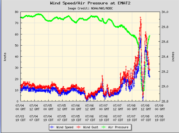
The eye of Hurricane Beryl passed directly over Matagorda, Texas.  A weather station at Matagorda, Texas (EMAT2) reported a sustained wind speed of 68 m.p.h. (110 km/h) when the northern part of the eyewall passed over the station.  The station also reported a wind gust of 86 m.p.h. (139 km/h).  The station reported a surface pressure of 980 mb when the eye of Hurricane Beryl was over it.

A weather station at Freeport, Texas (FPST2) reported a sustained wind speed of 75 m.p.h. (120 km/h) and a wind gust of 87 m.p.h. (141 km/h).

A weather station at the North Jetty Entrance to Galveston Bay (GNJT2) reported a sustained wind speed of 72 m.p.h. (117 km/h) and a wind gust of 82 m.p.h. (132 km/h).

After Hurricane Beryl made landfall on the coast of Texas, the center of Beryl’s circulation passed just to the west of Houston.  The eastern side of Beryl’s eyewall passed over Houston.  Beryl brought strong winds and heavy rain to the area around Houston.

A weather station at Houston Hobby Airport reported a sustained wind speed of 58 m.p.h. (94 km/h) and a wind gust of 84 m.p.h. 135 km/h).  The weather station also reported 4.15 inches (105 mm) of rain.

A weather station at Houston Intercontinental Airport reported a sustained wind speed of 59 m.p.h. (95 km/h) and a wind gust of 82 m.p.h. (132 km/h).  The station also reported 4.31 inches of rain.

The strong winds in Hurricane Beryl caused widespread electricity outages in east Texas.  There were reports of 2.5 million customers without electricity.

The strong winds in Hurricane Beryl caused a storm surge along the coast of Texas.  There were reports of water level rises of 5 feet (1.5 meters) at multiple locations along the coast.

Tropical Storm Beryl will move under the southeastern part of an upper level trough over the Central U.S.  The upper level trough will steer Beryl toward the north-northeast during the next 12 hours.  On its anticipated track, Tropical Storm Beryl will move over northeast Texas later today.  The upper level trough will steer Beryl toward the northeast on Tuesday.  Beryl will move over Arkansas on Tuesday morning.

Tropical Storm Beryl will continue to weaken gradually as it moves farther inland.  Beryl will continue to produce strong winds over east Texas during the next few hours.  Widespread minor wind damage is likely to occur.  There are also likely to be additional electricity outages.  Tropical Storm Beryl could drop up to 8 inches (200 mm) of rain on some locations.   Heavy rain is likely to cause flooding.  Flood Watches are in effect for parts of eastern Texas.  Flood Watches are also in effect for parts of southeastern Oklahoma, southwestern Arkansas and northwestern Louisiana.  Tropical Storm Beryl will continue to cause a storm surge of up to 5 feet (1.5 meters) along the coast until the wind speeds decrease when Beryl moves farther away.


Hurricane Beryl Makes Landfall in Texas

Hurricane Beryl made landfall on the coast of Texas at Matagorda early on Monday morning.  At 5:00 a.m. EDT on Monday the center of Hurricane Beryl was located at latitude 28.6°N and longitude 96.0°W which put the center at Matagorda, Texas.  Beryl was moving toward the north at 12 m.p.h. (19 km/h).  The maximum sustained wind speed was 80 m.p.h. (130 km/h) and there were wind gusts to 100 m.p.h. (160 km/h).  The minimum surface pressure was 979 mb.

A Hurricane Warning was in effect for the portion of the coast from Mesquite Bay to Port Bolivar, Texas.

A Tropical Storm Warning was in effect for the portion of the coast from Port Bolivar to Sabine Pass, Texas.

A Storm Surge Warning was in effect for the portion of the coast from Mesquite Bay to Sabine Pass, Texas.

The center of Hurricane Beryl made landfall on the coast of Texas at Matagorda early on Monday morning.  Beryl was intensifying at the time of landfall.  A circular eye with a diameter of 32 miles (52 km) was present at the center of Beryl’s circulation.  The eye of Hurricane Beryl passed directly over Matagorda Texas.  The eye was surrounded by a ring of strong thunderstorms and the strongest winds were occurring in that ring of storms.  Bands of showers and thunderstorms were revolving around the center of Hurricane Beryl.

The strongest winds in Hurricane Beryl were occurring in the eastern half of Beryl’s circulation.  Winds to hurricane force extended out 45 miles (75 km) in the eastern side of Beryl.  Winds to tropical storm force extended out 115 miles (185 km) from the center of Hurricane Beryl.

The Hurricane Intensity Index (HII) for Hurricane Beryl was 11.5.  The Hurricane Size Index (HSI) was 10.3 and the Hurricane Wind Intensity Size Index (HWISI) was 21.8.  Hurricane Beryl was not quite as strong as Hurricane Dolly was when Dolly hit South Texas in 2008.  Beryl was a little smaller that Dolly was.

A weather station at Matagorda, Texas (EMAT2) reported a sustained wind speed of 68 m.p.h. (110 km/h) when the northern part of the eyewall passed over the station.  The station also reported a wind gust of 86 m.p.h. (139 km/h).  The station reported a surface pressure of 980 mb when the eye of Hurricane Beryl was over it.

A weather station at Freeport, Texas (FPST2) reported a sustained wind speed of 71 m.p.h. (115 km/h) and a wind gust of 86 m.p.h. (139 km/h).

Heavy rain was falling over parts of eastern Texas.  Heavy rain was falling in Houston and Galveston.

Hurricane Beryl will move around the western part of a high pressure system over the southeastern U.S.  The high pressure system will steer Beryl toward the north during the next 12 hours. Hurricane Beryl will start to move toward the northeast on Monday night.  On its anticipated track, the center of Hurricane Beryl will pass over Bay City, Texas.  The center of Beryl will pass just to the west of Houston in a few hours.

Hurricane Beryl will start to weaken gradually as the center of Beryl’s circulation moves farther inland.  Beryl will bring strong winds and heavy rain to parts of eastern Texas.  Hurricane Beryl will be capable of causing regional minor damage.  The strongest winds will be in the eastern side of Hurricane Beryl.  Beryl will bring strong winds to Galveston and Houston.  The strong winds are likely to cause electricity outages.

Hurricane Beryl could drop up to 10 inches (250 mm) of rain on some locations.   Heavy rain is likely to cause flooding.  Flood Watches are in effect for parts of eastern Texas.  Flood Watches are also in effect for parts of southeastern Oklahoma, southwestern Arkansas and northwestern Louisiana.  Hurricane Beryl could also cause a storm surge of up to 10 feet (3 meters) where the wind pushes water toward the coast.


Beryl Strengthens Back to a Hurricane

Former Tropical Storm Beryl strengthened back to a hurricane on Sunday night as it neared the coast of Texas.  At 12:00 a.m. EDT on Monday the center of Hurricane Beryl was located at latitude 27.7°N and longitude 95.7°W which put the center about 65 miles (105 km) south-southeast of Matagorda, Texas.   Beryl was moving toward the north-northwest at 10 m.p.h. (16 km/h).   The maximum sustained wind speed was 75 m.p.h. (120 km/h) and there were wind gusts to 90 m.p.h. (145 km/h).   The minimum surface pressure was 985 mb.

A Hurricane Warning was in effect for the portion of the coast from Mesquite Bay to Port Bolivar, Texas.

A Tropical Storm Warning was in effect for the portion of the coast from Mesquite Bay to Port Mansfield, Texas.  A Tropical Storm Warning was also in effect for the portion of the coast from Port Bolivar to Sabine Pass, Texas.

A Storm Surge Warning was in effect for the portion of the coast from Mesquite Bay to Sabine Pass, Texas.

Former Tropical Storm Beryl strengthened back to a hurricane as it neared the coast of Texas on Sunday night.  Beryl strengthened slowly but steadily on Sunday night.  The inner end of a rainband wrapped around the center of Beryl’s circulation.  A circular eye with a diameter of 45 miles (75 km) was at the center of Hurricane Beryl.  The eye was surrounded by a broken ring of thunderstorms and the strongest winds were occurring in that ring of storms.  Bands of showers and thunderstorms revolved around the center of Hurricane Beryl.  Storms near the center of circulation generated upper level divergence that pumped mass away from the hurricane.  The removal of mass caused the surface pressure to decrease slowly.

The circulation around Hurricane Beryl became more symmetrical on Sunday.  Winds to tropical storm force extended out 115 miles (185 km) from the center of Beryl’s circulation.

Hurricane Beryl will move through an environment that will be favorable for intensification during the next few hours.  Beryl will move over water where the Sea Surface Temperatures are near 30°C.  It will move under an upper level ridge over the Gulf of Mexico.  The upper level winds are weak in the ridge and there will be be little vertical wind shear.  Hurricane Beryl will continue to intensify during the next few hours.  There could be a brief period of more rapid intensification if an inner core with an eye and and eyewall develops fully.

Hurricane Beryl will move around the southwestern part of a high pressure system over the southeastern U.S.   The high pressure system will steer Beryl toward the north during the next 24 hours.   On its anticipated track, Hurricane Beryl will make landfall on the coast of Texas on Monday.  The center of Beryl’s circulation will make landfall between Matagorda and Galveston, Texas.

Hurricane Beryl will bring strong winds and heavy rain to parts of eastern Texas.  The strong winds are likely to cause power outages.  Beryl could bring strong winds to Galveston and Houston.  Up to 10 inches (250 mm) of rain could fall in some locations.  Heavy rain is likely to cause flooding.  Flood Watches are in effect for parts of eastern Texas.  Flood Watches are also in effect for parts of southeastern Oklahoma, southwestern Arkansas and northwestern Louisiana.  Hurricane Beryl could also cause a storm surge of up to 10 feet (3 meters) where the wind pushes water toward the coast.