
Tag Archives: Georgia

Low Pressure System Drops Heavy Rain Near Georgia Coast

A low pressure system designated as Invest 92L was dropping heavy rain near the coast of Georgia on Saturday morning.  At 8:00 a.m. EDT on Saturday the center of the low pressure system was located at latitude 31.1°N and longitude 81.5°W which put the center about 5 miles (10 km) southeast of Brunswick, Georgia.  The low pressure system was moving toward the west-northwest at 5 m.p.h. (8 km/h).  The maximum sustained wind speed was 30 m.p.h. (50 km/h) and there were wind gusts to 40 m.p.h. (65 km/h).  The minimum surface pressure was 1015 mb.

A low pressure system designated as Invest 92L was dropping heavy rain near the coast of Georgia on Saturday morning.
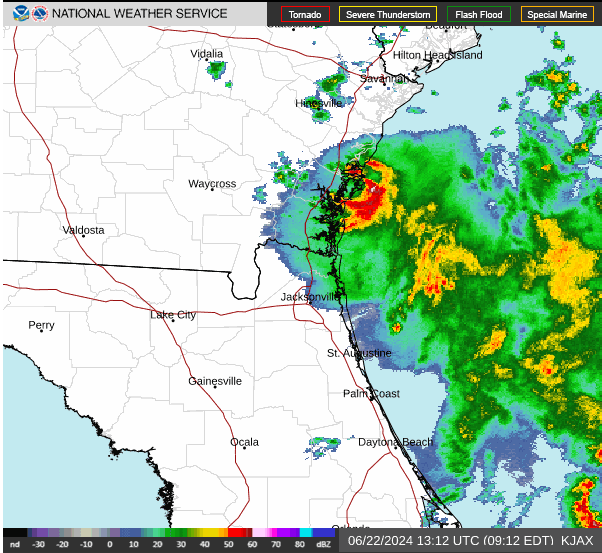
The center of the low pressure system was near Brunswick, Georgia.  There was a well defined center of circulation evident on the U.S. National Weather Service radar at Jacksonville, Florida.  The center of circulation was moving slowly near the coast of Georgia.  The heaviest rain was falling in a ring that wrapped around the eastern side of the center of Invest 92L.  Other bands of rain were over the Atlantic Ocean.

The low pressure system is forecast to move slowly inland over eastern Georgia.  Heavy rain could fall over areas near the coast as Invest 92L moves inland.  Heavy rain could cause flooding in some locations.

Elsewhere, a large low pressure system formed over the southwestern Gulf of Mexico near the area where Tropical Storm Alberto formed.  The low pressure system has been designated as Invest 93L.  At 8:00 a.m. EDT on Saturday the center of Invest 93L was located at latitude 21.0°N and longitude 95.7°W which put it about 125 miles (200 km) east-southeast of Tampico, Mexico.  The low pressure system was moving toward the northwest at 13 m.p.h. (21 km/h).  The maximum sustained wind speed was 35 m.p.h. (55 km/h) and there were wind gusts to 45 m.p.h. (75 km/h).  The minimum surface pressure was 1005 mb.

Invest 93L will move through an environment somewhat favorable for the formation of a tropical cyclone during the next 24 hours.  Invest 93L will move over water where the Sea Surface Temperatures are near 30°C.  It will move under the southeastern part of an upper level ridge that stretches from Baja California to the Great Lakes.  The ridge will produce northeasterly winds that will blow toward the top of the low pressure system.  Those winds will cause moderate vertical wind shear.  The wind shear will inhibit intensification, but the shear may not be strong enough to prevent Invest 93L from developing into a tropical cyclone.  The U.S. National Hurricane Center is indicating that the probability is 50% that Invest 93L develops into a tropical cyclone.

The low pressure system designated as Invest 93L will move around the southern side of a large high pressure system over the eastern U.S.  The high pressure system will steer Invest 93L toward the west-northwest during the next 24 hours.  On its anticipated track, Invest 93L will approach the coast of Mexico near Tampico on Sunday.

The low pressure system designated as Invest 93L will drop heavy rain over some of the same areas where Tropical Storm Alberto dropped heavy rain.  Invest 93L is very likely to cause major flash floods in parts of northern Mexico.

A U.S. Air Force Reserve Hurricane Hunter aircraft is scheduled to investigate the low pressure system designated as Invest 93L later today, if necessary.

Low Pressure System Approaches Southeast U.S.

A small low pressure system was approaching the Southeast U.S. on Friday morning.  The low pressure system was officially designated as Invest 92L by the U.S. National Hurricane Center.  At 11:00 a.m. EDT on Friday the center of the low pressure system was located at latitude 30.4°N and longitude 79.5°W which put it about 135 miles (215 km) east of Jacksonville, Florida.  The low pressure system was moving toward the west-northwest at 15 m.p.h. (24 km/h).  The maximum sustained wind speed was 35 m.p.h. (55 km/h) and there were wind gusts to 45 m.p.h. (75 km/h).  The minimum surface pressure was 1014 mb.

The low pressure system approaching the Southeast U.S. was officially designated as Invest 92L, but it exhibited many of the characteristics of a tropical depression.  Thunderstorms were occurring near the center of the low pressure system.  Thunderstorms were also occurring in bands in the southern half of the circulation around Invest 92L.  Bands in the northern half of the circulation consisted primarily of showers and lower clouds, although there were also a few thunderstorms.  Storms near the center of circulation generated upper level divergence that pumped mass away to the southwest of the low pressure system.

The low pressure system approaching the Southeast U.S. will move through an environment somewhat favorable for intensification during the next few hours.  The low pressure system will move over water where the Sea Surface Temperatures are near 28°C.  It will move under the southeastern part of an upper level ridge that stretches from Texas to Maine.  The upper level ridge will produce northeasterly winds that will blow toward the top of the low pressure system.  The wind shear will inhibit intensification.  The low pressure system could strengthen a little, if the upper level winds do not get stronger.

The low pressure system will move around the southern side of a high pressure system that is over the western Atlantic Ocean and eastern U.S.  The high pressure system will steer Invest 92L toward the west-northwest during the next 24 hours.  On its anticipated track, the low pressure system will make landfall on the coast of Georgia later on Friday.

The low pressure system designated as Invest 92L will bring gusty winds and locally heavy rain to parts of northeastern Florida and eastern Georgia.  It will also generate waves and rip currents along the coast.  The waves could cause some minor coastal erosion.

Hurricane Idalia Brings Wind and Rain to Southeast U.S.

Former Hurricane Idalia brought wind and rain to southeast U.S. on Wednesday. Idalia weakened to a tropical storm on Wednesday afternoon as it moved across southeastern Georgia. At 5:00 p.m. EDT on Wednesday the center of Tropical Storm Idalia was located at latitude 32.2°N and longitude 81.7°W which put it about 40 miles (65 km) west of Savannah, Georgia. Idalia was moving toward the northeast at 21 m.p.h. (33 km/h). The maximum sustained wind speed was 70 m.p.h. (110 km/h) and there were wind gusts to 85 m.p.h. (135 km/h). The minimum surface pressure was 961 mb.

A Tropical Storm Warning was in effect for the portion of the coast from the Flagler/Volusia County Line, Florida to the North Carolina/Virginia border. The Tropical Storm Warning included Charleston, South Carolina. The Tropical Storm Warning also included Pamlico Sound and Albemarle Sound.

Former Hurricane Idalia made landfall on the west coast of Florida near Keaton Beach on Wednesday morning. A NOAA C-MAN station at Keaton Beach (KTNF1) measured a sustained wind speed of 61 m.p.h. (98 km/h) and a wind gust of 77 m.p.h. (124 km/h). Idalia moved northeast across northern Florida and southeastern Georgia during Wednesday. The center of Idalia passed just to the southeast of Perry, Florida. A weather station in Perry (KFPY) measured a sustained wind speed of 62 m.p.h. (100 km/h) and a wind gust of 85 m.p.h. (137 km/h). Idalia weakened steadily as it moved over land. The center of Idalia’s circulation passed southeast of Valdosta, Georgia. A weather station in Valdosta (KVLD) measured a sustained wind speed of 39 m.p.h. (63 km/h) and a wind gust of 67 m.p.h. (108 km/h).

An upper level trough over the eastern U.S. will steer Tropical Storm Idalia toward the northeast during the next 12 hours. The upper level trough will pass north of Idalia on Thursday. The trough will steer Tropical Storm Idalia toward the east-northeast on Thursday. On its anticipated track, the center of Tropical Storm Idalia will move near the coast of South Carolina and North Carolina.

Tropical Storm Idalia will weaken gradually during the next 24 hours. The strongest winds in Idalia will occur over the Atlantic Ocean and along the coast of South Carolina and North Carolina. The winds will be weaker in parts of South Carolina and North Carolina that are farther inland. The southerly winds in the eastern part of Idalia will blow water toward the coast. Those winds will cause a storm surge along the coast of up to 7 feet (2 meters). A Storm Surge Warning was in effect for the portion of the coast from St. Catherine’s Sound, Georgia to South Santee River, South Carolina.

The southerly winds blowing in the eastern side of Tropical Storm Idalia will converge with northerly winds blowing around a high pressure system over the Great Lakes. The low level convergence of air will enhance rising motion and prolonged rainfall could occur over inland parts of South Carolina and North Carolina. Flood Watches are in effect for parts of eastern Georgia, South Carolina and North Carolina.

Elsewhere over the Atlantic Ocean, bands in the eastern side of Hurricane Franklin were producing gusty winds in Bermuda. At 5:00 p.m. EDT on Wednesday the center of Hurricane Franklin was located at latitude 34.2°N and longitude 65.9°W which put it about 145 miles (235 km) north-northwest of Bermuda. Franklin was moving toward the northeast at 13 m.p.h. (21 km/h). The maximum sustained wind speed was 105 m.p.h. (165 km/h) and there were wind gusts to 125 m.p.h. (200 km/h). The minimum surface pressure was 961 mb. A Tropical Storm Warning was in effect for Bermuda.

Hurricane Idalia Hits North Florida

Hurricane Idalia hit North Florida on Wednesday morning. At 8:00 a.m. EDT on Wednesday the center of Hurricane Idalia was located at latitude 29.9°N and longitude 83.5°W which put it about 10 miles (15 km) south-southeast of Perry, Florida. Idalia was moving toward the north-northeast at 18 m.p.h. (30 km/h). The maximum sustained wind speed was 120 m.p.h. (195 km/h) and there were wind gusts to 140 m.p.h. (220 km/h). The minimum surface pressure was 950 mb.

A Hurricane Warning was in effect for the portion of the coast from Indian Pass to the middle of Longboat Key, Florida. The Hurricane Warning included Tampa Bay. A Hurricane Warning was also in effect for the portion of the coast from Altamaha Sound, Georgia to Edisto Beach, South Carolina. . A Hurricane Watch was in effect for the portion of the coast from the Mouth of the St. Mary’s River, Florida to Altamaha Sound, Georgia. A Hurricane Watch was in effect for the portion of the coast from Edisto Beach to South Santee River, South Carolina. The Hurricane Watch included Charleston, South Carolina. A Tropical Storm Warning was in effect for the portion of the coast from Bonita Beach to the middle of Longboat Key, Florida. A Tropical Storm Warning was also in effect for the portion of the coast from Indian Pass to Mexico Beach, Florida. A Tropical Storm Warning was in effect for the portion of the coast from Sebastian Inlet, Florida to Altamaha Sound, Georgia. A Tropical Storm Warning was in effect for the portion of the coast from Edisto Beach, South Carolina to the North Carolina/Virginia border. The Tropical Storm Warning included Charleston, South Carolina, Pamlico Sound and Albemarle Sound.

The center of Hurricane Idalia made landfall on the coast of Florida near Keaton Beach on Wednesday morning. The maximum sustained wind speed was 125 m.p.h. (200 km/h) at the time of landfall. Winds to hurricane force extended out 25 miles (40 km) from the center of Hurricane Idalia. Winds to tropical storm force extended out 140 miles (220 km) in the eastern side of Idalia’s circulation. Winds to tropical storm force extended out 70 miles (110 km) in the western side of Idalia. The Hurricane Intensity Index (HII) was 23.6. The Hurricane Size Index (HSI) was 9.6 and the Hurricane Wind Intensity Size Index (HWISI) was 33.2. Hurricane Idalia was similar in size and intensity to Hurricane Dennis when Dennis hit Northwest Florida in 2005.

The winds in Hurricane Idalia were blowing water toward the west coast of Florida. Those winds were causing a storm surge along the coast. A Storm Surge Warning was in effect for the portion of the coast from Englewood to Indian Pass, Florida. The Storm Surge Warning included Tampa Bay. A Storm Surge Warning was also in effect for the portion of the coast from St. Catherine’s Sound, Georgia to South Santee River, South Carolina. The Storm Surge Warning included Charleston, South Carolina.

Hurricane Idalia was dropping heavy rain over parts of northern Florida, southern Georgia and southwestern South Carolina. Heavy rain is likely to cause flash floods in some locations. Flood Watches were in effect for parts of northern Florida, southern Georgia, South Carolina and North Carolina.

An upper level trough over the central U.S. will steer Hurricane Idalia toward the northeast during the next 24 hours. On its anticipated track, Hurricane Idalia will move inland over northern Florida and southeastern Georgia. The center of Idalia will be near Charleston, South Carolina on Wednesday night. Hurricane Idalia will weaken gradually as the center of circulation moves farther inland. Idalia will bring strong gusty winds to northern Florida, southeastern Georgia, coastal South Carolina and coastal North Carolina. Widespread electricity outages could occur. The wind will continue to blow water toward the west coast of Florida during the next few hours and the storm surge will continue. Hurricane Idalia will continue to drop locally heavy rain over parts of northern Florida, and southern Georgia. Heavy rain will spread over parts of South Carolina and North Carolina.

Elsewhere over the Atlantic Ocean, Hurricane Franklin was west-northwest of Bermuda. At 8:00 a.m. EDT on Wednesday the center of Hurricane Franklin was located at latitude 33.3°N and longitude 67.6°W which put it about 180 miles (290 km) west-northwest of Bermuda. Franklin was moving toward the northeast at 13 m.p.h. (21 km/h). The maximum sustained wind speed was 110 m.p.h. (175 km/h) and there were wind gusts to 130 m.p.h. (210 km/h). The minimum surface pressure was 956 mb. A Tropical Storm Warning was in effect for Bermuda.

Hurricane Idalia Strengthens to Cat. 2

Hurricane Idalia strengthened to Category 2 on the Saffir-Simpson Scale on Tuesday afternoon. At 5:00 p.m. EDT on Tuesday the center of Hurricane Idalia was located at latitude 26.1°N and longitude 84.8°W which put it about 195 miles (310 km) southwest of Tampa, Florida. Idalia was moving toward the north at 16 m.p.h. (26 km/h). The maximum sustained wind speed was 100 m.p.h. (160 km/h) and there were wind gusts to 120 m.p.h. (195 km/h). The minimum surface pressure was 972 mb.

A Hurricane Warning was in effect for the portion of the coast from Indian Pass to the middle of Longboat Key, Florida. The Hurricane Warning included Tampa Bay. A Hurricane Watch was in effect for the portion of the coast from the Mouth of the St. Mary’s River, Florida to South Santee River, South Carolina. The Hurricane Watch included Charleston, South Carolina. A Tropical Storm Warning was in effect for the portion of the coast from Chokoloskee to the middle of Longboat Key, Florida. A Tropical Storm Warning was also in effect for the portion of the coast from Indian Pass to Mexico Beach, Florida. A Tropical Storm Warning was in effect for the Dry Tortugas. A Tropical Storm Warning was in effect for the portion of the coast from Sebastian Inlet, Florida to Surf City, North Carolina. A Tropical Storm Watch was in effect for the Lower Florida Keys west of Seven Mile Bridge. A Tropical Storm Watch was also in effect for the portion of the coast from Surf City, North Carolina to the North Carolina/Virginia border. The Tropical Storm Watch included Pamlico Sound and Albemarle Sound.

Hurricane Idalia intensified steadily during Tuesday afternoon. A circular eye with a diameter of 30 miles (50 km) was at the center of Idalia’s circulation. The eye was surrounded by a ring of thunderstorms and the strongest winds were occurring in that ring of storms. Bands of showers and thunderstorms were revolving around the core of Idalia’s circulation. Storms near the core generated upper level divergence that pumped mass away from the hurricane.

The circulation around Hurricane Idalia grew larger when Idalia intensified. Winds to hurricane force extended out 25 miles (40 km) from the center of Idalia’s circulation. Winds to tropical storm force extended out 160 miles (260 km) in the eastern side of Hurricane Ida. Winds to tropical storm force extended out 70 miles in the western side of Ida’s circulation. The Hurricane Intensity Index (HII) for Hurricane Ida was 16.5. The Hurricane Size Index (HSI) was 8.0 and the Hurricane Wind Intensity Size Index (HWISI) was 24.5.

Hurricane Idalia will move through an environment that will be favorable for intensification during the next 12 hours. Idalia will be over water where the Sea Surface Temperatures are near 30°C. It will move into a region between an upper level ridge over the Yucatan Peninsula and an upper level trough over the central U.S. The upper level winds are weaker between the ridge and the trough and there will be little vertical wind shear during the next 12 hours. The upper level winds will be stronger when Idalia moves closer to the upper level trough on Wednesday morning. Hurricane Idalia will intensify during the next 12 hours. Idalia could rapidly intensify at times. Hurricane Idalia is likely to strengthen to a major hurricane.

Hurricane Idalia will move around the western end of high pressure system over the western Atlantic Ocean. The high pressure system and the upper level trough over the central U.S. will steer Idalia toward the north-northeast during the next 12 hours. The upper level trough will turn Idalia toward the northeast on Wednesday. On its anticipated track, Hurricane Idalia will likely to make landfall on the coast of the northeast Gulf of Mexico on Wednesday morning. Idalia is likely to make landfall as a major hurricane.

Hurricane Idalia is forecast to be a major hurricane when it reaches the coast of Florida. Idalia could be similar in size and intensity to Hurricane Dennis when Dennis hit Northwest Florida in 2005. Hurricane Idalia is likely to make landfall in an area where high storm surges can occur. Idalia could cause a storm surge of up to 15 feet (4.5 meters) near where the center makes landfall. A Storm Surge Warning has been issued for the portion of the coast from Englewood to Indian Pass, Florida. The Storm Surge Warning includes Tampa Bay. Hurricane Idalia will bring strong winds and heavy rain to parts of central and northern Florida. Idalia will be capable of causing major damage over parts of northern and northeastern Florida. Widespread outages of electricity are likely. Heavy rain could cause flash floods in some locations. Strong winds and heavy rain will spread over eastern Georgia, South Carolina and North Carolina when Idalia moves toward the northeast. Flood Watches are in effect for parts of northern Florida, eastern Georgia, South Carolina and North Carolina.

Elsewhere, Hurricane Franklin was west of Bermuda. At 5:00 p.m. EDT on Tuesday the center of Hurricane Franklin was located at latitude 31.4°N and longitude 69.9°W which put it about 305 miles (490 km) west of Bermuda. Franklin was moving toward the northeast at 12 m.p.h. (19 km/h). The maximum sustained wind speed was 125 m.p.h. (200 km/h) and there were wind gusts to 150 m.p.h. (240 km/h). The minimum surface pressure was 947 mb. A Tropical Storm Warning was in effect for Bermuda.

Idalia Strengthens to a Hurricane

Former Tropical Storm Idalia strengthened to a hurricane over the southeastern Gulf of Mexico on Tuesday morning. At 8:00 a.m. EDT on Tuesday the center of Hurricane Idalia was located at latitude 23.8°N and longitude 84.8°W which put it about 320 miles (515 km) south-southwest of Tampa, Florida. Idalia was moving toward the north at 14 m.p.h. (22 km/h). The maximum sustained wind speed was 80 m.p.h. (130 km/h) and there were wind gusts to 95 m.p.h. (145 km/h). The minimum surface pressure was 977 mb.

A Hurricane Warning was in effect for the portion of the coast from Indian Pass to the middle of Longboat Key, Florida. The Hurricane Warning included Tampa Bay. A Hurricane Warning was also in effect for the Cuban Province of Pinar del Rio. A Hurricane Watch was in effect for the portion of the coast from Englewood to the middle of Longboat Key, Florida. A Tropical Storm Warning was in effect for the portion of the coast from Chokoloskee to the middle of Longboat Key, Florida. A Tropical Storm Warning was also in effect for the portion of the coast from Indian Pass to Mexico Beach, Florida. A Tropical Storm Warning was in effect for the Dry Tortugas. A Tropical Storm Warning was in effect for the portion of the coast from Sebastian Inlet, Florida to Altamaha Sound, Georgia. A Tropical Storm Warning was also in effect for the Cuban Province. of Isle of Youth. A Tropical Storm Watch was in effect for the Lower Florida Keys west of Seven Mile Bridge. A Tropical Storm Watch was also in effect for the portion of the coast from Altamaha Sound, Georgia to South Santee River, South Carolina.

Former Tropical Storm Idalia strengthened to a hurricane after the center of Idalia moved north of the western end of Cuba. The inner end of a rainband wrapped around the center of Idalia’s circulation. A weather radar at La Bajada, Cuba showed a small eye developed at the center of Hurricane Idalia. The eye was surrounded by a ring of thunderstorms and the strongest winds were occurring in that ring of storms. Bands of showers and thunderstorms were revolving around the core of Idalia’s circulation. Storms near the core generated upper level divergence that pumped mass away from the hurricane.

The circulation around Hurricane Idalia grew larger when Idalia intensified. Winds to hurricane force extended out 20 miles (30 km) from the center of Idalia’s circulation. Winds to tropical storm force extended out 160 miles (260 km) from the center of circulation.

Hurricane Idalia will move into an environment that will be favorable for intensification during the next 24 hours. Idalia will be over water where the Sea Surface Temperatures are near 30°C. It will move into a region between an upper level ridge over the Yucatan Peninsula and an upper level trough over the central U.S. The upper level winds are weaker between the ridge and the trough and there will be little vertical wind shear during the next 12 to 18 hours. The upper level winds will be stronger when Idalia moves closer to the upper level trough on Wednesday morning. Hurricane Idalia will intensify during the next 24 hours. Idalia could intensify rapidly now that an inner core with an eye and an eyewall have developed. Hurricane Idalia could strengthen to a major hurricane.

Tropical Storm Idalia will move around the western end of high pressure system over the western Atlantic Ocean. The high pressure system and the upper level trough over the central U.S. will steer Idalia toward the north-northeast during the next 24 hours. On its anticipated track, Hurricane Idalia is likely to make landfall on the coast of the northeast Gulf of Mexico on Wednesday morning. Idalia could make landfall as a major hurricane.

Hurricane Idalia is forecast to be a major hurricane when it reaches the coast of Florida. Idalia could be similar in size and intensity to Hurricane Dennis when Dennis hit Northwest Florida in 2005. Hurricane Idalia is likely to make landfall in an area where high storm surges can occur. Idalia could cause a storm surge of up to 12 feet (3.5 meters) near where the center makes landfall. A Storm Surge Warning has been issued for the portion of the coast from Englewood to Indian Pass, Florida. The Storm Surge Warning includes Tampa Bay. Hurricane Idalia will bring strong winds and heavy rain to parts of central and northern Florida. Widespread outages of electricity are likely. Heavy rain could cause flash floods in some locations.

Elsewhere, Hurricane Franklin was a Category 4 hurricane on the Saffir-Simpson Scale over the Atlantic Ocean west-southwest of Bermuda. At 8:00 a.m. EDT on Tuesday the center of Hurricane Franklin was located at latitude 30.4°N and longitude 70.7°W which put it about 370 miles (600 km) west-southwest of Bermuda. Franklin was moving toward the north-northeast at 9 m.p.h. (15 km/h). The maximum sustained wind speed was 140 m.p.h. (220 km/h) and there were wind gusts to 165 m.p.h. (270 km/h). The minimum surface pressure was 941 mb. A Tropical Storm Watch was in effect for Bermuda.

Tropical Storm Idalia Causes Hurricane Warning for West Coast of Florida

The imminent threat posed by Tropical Storm Idalia caused the issuance of a Hurricane Warning for the west coast of Florida on Monday morning. At 11:00 a.m. EDT on Monday the center of Tropical Storm Idalia was located at latitude 20.8°N and longitude 85.2°W which put it about 80 miles (130 km) south-southwest of the western end of Cuba. Idalia was moving toward the north at 8 m.p.h. (13 km/h). The maximum sustained wind speed was 65 m.p.h. (105 km/h) and there were wind gusts to 80 m.p.h. (130 km/h). The minimum surface pressure was 990 mb.

A Hurricane Warning was in effect for the portion of the coast from the Ochlockonee River to the middle of Longboat Key, Florida. The Hurricane Warning included Tampa Bay. A Hurricane Warning was also in effect for the Cuban Province of Pinar del Rio. A Hurricane Watch was in effect for the portions of the coast from Englewood to the middle of Longboat Key, Florida and from the Ochlockonee River to Indian Pass, Florida. A Tropical Storm Warning was in effect for the portion of the coast from Chokoloskee to the middle of Longboat Key, Florida. A Tropical Storm Warning was also in effect for the portion of the coast from the Ochlockonee River to Indian Pass, Florida. A Tropical Storm Warning was in effect for the Dry Tortugas. A Tropical Storm Warning was in effect for the portion of the coast from Tulum to Rio Lagartos, Mexico. The Tropical Storm Warning included Cozumel. A Tropical Storm Warning was also in effect for the Cuban Province. of Isle of Youth. A Tropical Storm Watch was in effect for the Lower Florida Keys west of Seven Mile Bridge. A Tropical Storm Watch was also in effect for the portion of the coast from Sebastian Inlet, Florida to Altamaha Sound, Georgia.

Tropical Storm Idalai strengthened gradually on Monday morning. Winds to tropical storm force extended out 100 miles (160 km) from the center of Idalia’s circulation. Even though Tropical Storm Idalia was stronger, the distribution of thunderstorms was asymmetrical. Most of the thunderstorms in Idalia were in bands in the southern and eastern parts of the circulation. Bands north and west of the center of circulation consisted primarily of showers and lower clouds. Tropical Storm Idalia was under the eastern part of an upper level ridge over the Yucatan Peninsula. The ridge was producing northeasterly winds that were blowing toward the top of Idalia’s circulation. Those winds were causing vertical wind shear and the wind shear was causing the asymmetrical distribution of thunderstorms.

Tropical Storm Idalia will move into an environment that will become more favorable for intensification during the next 24 hours. Idalia will be over water where the Sea Surface Temperatures are near 30°C. It will move into a region between the upper level ridge over the Yucatan Peninsula and an upper level low over the northern Gulf of Mexico. The upper level winds are weaker between the ridge and the low and there will be less vertical wind shear. Tropical Storm Idalia will intensify to a hurricane during the next 24 hours. Idalia could intensify rapidly when the upper level winds weaken. Idalia could strengthen to a major hurricane on Tuesday.

Tropical Storm Idalia will move around the western end of high pressure system over the western Atlantic Ocean. The high pressure system will steer Idalia toward the north during the next 24 hours. The center of Idalia will pass near the western end of Cuba in a few hours. On its anticipated track Tropical Storm Idalia will move over the eastern Gulf of Mexico on Monday night. An upper level trough over the eastern U.S. will turn Idalia toward the northeast later on Tuesday. Idalia is likely to make landfall on the west coast of Florida on Wednesday morning. Idalia could make landfall as a major hurricane.

Tropical Storm Idalia will drop heavy rain over parts of the northeastern Yucatan Peninsula and western Cuba. Heavy rain could cause flash floods in some locations.

Tropical Storm Idalia could be be a major hurricane when it reaches the west coast of Florida. Idalia is likely to make landfall in an area where high storm surges can occur. Idalia could cause a storm surge of up to 12 feet (3.5 meters) near where the center makes landfall. A Storm Surge Warning has been issued for the portion of the coast from Englewood to Ocholockonee River, Florida. The Storm Surge Warning includes Tampa Bay. Idalia will bring strong winds and heavy rain to parts of central and northern Florida. Widespread outages of electricity are likely. Heavy rain could cause flash floods in some locations.

Elsewhere, Hurricane Franklin rapidly intensified to Category 4 on the Saffir-Simpson Scale was over the Atlantic Ocean southwest of Bermuda. At 11:00 a.m. EDT on Monday the center of Hurricane Franklin was located at latitude 27.8°N and longitude 71.0°W which put it about 480 miles (770 km) southwest of Bermuda. Franklin was moving toward the north at 9 m.p.h. (15 km/h). The maximum sustained wind speed was 145 m.p.h. (230 km/h) and there were wind gusts to 170 m.p.h. (280 km/h). The minimum surface pressure was 937 mb. A Tropical Storm Watch was in effect for Bermuda.

Tropical Depression Nicole Drops Heavy Rain over Southeast U.S.

Tropical Depression Nicole dropped heavy rain over parts of the southeastern U.S. on Friday morning. At 10:00 a.m. EST on Friday the center of Tropical Depression Nicole was located at latitude 34.2°N and longitude 84.3°W which put it about 35 miles (55 km) north of Atlanta, Georgia. Nicole was moving toward the north-northeast at 23 m.p.h. (37 km/h). The maximum sustained wind speed was 30 m.p.h. (50 km/h) and there were wind gusts to 40 m.p.h. (65 km/h). The minimum surface pressure was 1001 mb.

Tropical Storm Nicole dropped heavy rain over parts of the southeastern U.S. on Friday morning. Heavy rain was falling over eastern Tennessee and eastern Kentucky. Bands in the far eastern side of Nicole’s circulation contained thunderstorms that were dropping heavy rain over parts of eastern South Carolina, eastern North Carolina and southeastern Virginia. Easterly winds blowing around the northern side of Nicole’s circulation were enhancing convergence and rising motion ahead of a cold front moving toward the eastern U.S. The enhanced convergence and rising motion was contributing to rain that was falling in the region from Delaware to Ohio.

The cold front approaching the eastern U.S. and an upper level trough over the central U.S. will steer Tropical Depression Nicole quickly toward the north-northeast during Friday. On its anticipated track the center of Tropical Depression Nicole will be over West Virginia by Friday evening. Heavy rain falling over parts of the southeastern U.S. and Appalachians could cause flooding. Flood Watches were in effect for parts of northern South Carolina, western North Carolina and southern Virginia. There could be enough low level wind shear for tornadoes to develop in the bands on the far eastern side of the circulation around Tropical Depression Nicole. A Tornado Watch was in effect for eastern South Carolina, eastern North Carolina and southeastern Virginia.

Tropical Storm Nicole Brings Wind and Rain to Florida

Tropical Storm Nicole brought wind and rain to Florida on Thursday. At 4:00 p.m. EST on Thursday the center of Tropical Storm Nicole was located at latitude 29.4°N and longitude 83.2°W which put it about 25 miles (40 km) northwest of Cedar Key, Florida. Nicole was moving toward the northwest at 15 m.p.h. (24 km/h). The maximum sustained wind speed was 45 m.p.h. (75 km/h) and there were wind gusts to 60 m.p.h. (95 km/h). The minimum surface pressure was 990 mb.

A Tropical Storm Warning was in effect for the portion of the coast from the Flagler/Volusia County Line, Florida to Altamaha Sound, Georgia. The Tropical Storm Warning included Jacksonville. A Tropical Storm Warning was also in effect for the portion of the coast from Aripeka to Indian Pass, Florida.

Tropical Storm Nicole brought wind and rain as it moved across Central Florida. Nicole weakened gradually as it moved across the Florida Peninsula, but it still had a well organized circulation. Bands of showers and thunderstorms were revolving around the center of circulation. Winds to tropical storm force extended out 170 miles (275 km) from the center of Nicole’s circulation.

The strongest winds in Tropical Storm Nicole occurred near the east coast of Florida on Thursday. A weather station in Daytona Beach reported a sustained wind speed of 49 m.p.h. (79 km/h) and a wind gust of 70 m.p.h. (113 km/h). A weather station in St. Augustine reported a sustained wind speed of 46 m.p.h. (74 km/h) and a wind gust of 59 m.p.h. (95 km/h). A weather station in Jacksonville reported a sustained wind speed of 37 m.p.h. (59 km/h) and a wind gust of 56 m.p.h. (91 km/h). The winds were weaker along the west coast of Florida. A weather station in Tampa reported a sustained wind speed of 29 m.p.h. (46 km/h) and a wind gust of 53 m.p.h. (85 km/h).

An upper level trough and a surface cold front over the central U.S. will turn Tropical Storm Nicole toward the northeast during Thursday night. The center of Nicole will be over southern Georgia on Thursday night and it could be over western South Carolina by Friday afternoon. Tropical Storm Nicole will continue to weaken during the next 24 hours. Nicole will produce gusty winds over northern Florida, southern Georgia and parts of South Carolina. Those winds could cause scattered power outages. The large waves causing serious beach erosion along the east coast of Florida will start to diminish on Friday. Waves could cause some erosion of beaches in Georgia and South Carolina on Friday when Tropical Storm Nicole moves farther to the north. Nicole could drop locally heavy rain over parts of northern Florida, southern Georgia, and South Carolina. Heavy rain could cause floods in some locations.

Hurricane Nicole Makes Landfall in Florida

Hurricane Nicole made landfall in Florida early on Thursday. Nicole weakened to a tropical storm after it made landfall. At 4:00 a.m. EST on Wednesday the center of Tropical Storm Nicole was located at latitude 27.8°N and longitude 80.7°W which put it about 60 miles (95 km) southeast of Orlando, Florida. Nicole was moving toward the west-northwest at 14 m.p.h. (22 km/h). The maximum sustained wind speed was 70 m.p.h. (110 km/h) and there were wind gusts to 85 m.p.h. (145 km/h). The minimum surface pressure was 981 mb.

A Tropical Storm Warning was in effect for the portion of the coast from Boca Raton, Florida to South Santee River, South Carolina. The Tropical Storm Warning included West Palm Beach, Ft. Pierce, Daytona Beach, Jacksonville, and Charleston, South Carolina. A Tropical Storm Warning was in effect for Lake Okeechobee. A Tropical Storm Warning was in effect for the portion of the coast from Bonita Beach to Indian Pass, Florida, The Tropical Storm Warning included Tampa and St. Petersburg.

According to the National Hurricane Center, the center of Hurricane Nicole made landfall on the east coast of Florida just to the south of Vero Beach. The maximum sustained wind speed was 75 m.p.h. (120 km) at the time of landfall. Winds to hurricane force extended out 25 miles (40 km) in the eastern side of Nicole’s circulation at the time of landfall. Winds to tropical storm force extended out 450 miles (725 km) from the center of circulation.

Hurricane Nicole weakened to a tropical storm after the center moved inland over Central Florida, but Nicole was bringing strong, gusty winds to Central Florida. A weather station in Vero Beach reported a sustained wind speed of 40 m.p.h. (65 km/h) and a wind gust of 60 m.p.h. (97 km/h). A weather station in Melbourne reported a sustained wind speed of 52 m.p.h. (84 km/h) and a wind gust of 64 m.p.h. (103 km/h). A weather station in Orlando reported a sustained wind speed of 43 m.p.h. (69 km/h) and a wind gust of 63 m.p.h. (102 km/h). Tropical Storm Nicole was dropping heavy rain over parts of the Florida Peninsula.

Tropical Storm Nicole will move around the southwestern part of a surface high pressure system near the East Coast of the U.S. The high pressure system will steer Nicole toward the northwest during the next 12 hours. On its anticipated track the center of Tropical Storm Nicole will move over northern Florida on Thursday evening. An upper level trough and a cold front will approach Nicole from the west on Thursday night. The upper level trough and cold front will steer Tropical Storm Nicole toward the northeast on Friday. The center of Nicole could be over South Carolina on Friday afternoon.

Tropical Storm Nicole will weaken gradually as it moves across Central Florida. Nicole will continue to bring strong, gusty winds to central and northern Florida. Gusty winds could cause widespread power outages. Even though the center of Nicole will be inland, easterly winds will continue to blow water toward the east coast of Florida. Tropical Storm Nicole could cause a storm surge of up to 5 feet (1.5 meters) in some locations. Large waves will continue to cause significant beach erosion. Nicole will drop heavy rain over parts of central and northern Florida and southern Georgia. Heavy rain could cause fresh water floods in some locations.