
Tag Archives: San Diego

Hurricane Simon Nears Western Mexico

Powerful Hurricane Simon was nearing the west coast of Mexico on Saturday afternoon.  At 5:00 p.m. EDT on Saturday the center of Hurricane Simon was located at latitude 17.6°N and longitude 104.8°W which put the center about 100 miles (160 km) south-southwest of Manzanillo, Mexico.   Simon was moving toward the north at 5 m.p.h. (8 km/h).  The maximum sustained wind speed was 150 m.p.h. (240 km/h) and there were wind gusts to 175 m.p.h. (280 km/h).  The minimum surface pressure was 932 mb.

A Hurricane Warning is in effect for the portion of the coast from Punta San Telmo to El Roblito, Mexico.  The Hurricane Warning includes Manzanillo and Puerto Vallarta.

A Hurricane Warning is in effect for Las Islas Marias.

A Tropical Storm Watch is in effect for the portion of the coast from Punta San Telmo to Lazaro Cardenas, Mexico.

Hurricane Simon intensified to Category 4 on the Saffir-Simpson Scale on Saturday.
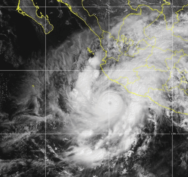
The inner end of a rainband wrapped around the existing eye and eyewall on Saturday.  Concentric eyewalls were at the center of Hurricane Simon.  The inner eyewall had a diameter of 14 miles (22 km).  The outer eyewall had a diameter of 40 miles (65 km).

Bands of showers and thunderstorms were revolving around the core of Simon’s circulation.  Storms near the core of Simon generated upper level divergence that pumped mass away from the hurricane.  The removal of mass caused the surface pressure to decrease.

The circulation around Hurricane Simon was small.  Winds to hurricane force extended out 25 miles (40 km) from the center of Simon’s circulation.  Winds to tropical storm force extended out 90 miles (145 km) from the center of Hurricane Simon.

The Hurricane Intensity Index (HII) for Hurricane Simon is 31.6.  The Hurricane Size Index (HSI) is 8.5 and the Hurricane Wind Intensity Size Index (HWISI) is 40.1.  Hurricane Simon is bigger and stronger than Hurricane Charley was when Charley hit southwest Florida in 2004.

Hurricane Simon will move through an environment favorable for intensification during the next 12 hours.  Simon will move over water where the Sea Surface Temperatures are near 30°C.  It will move under the middle of an upper level ridge that is over Mexico and the Eastern North Pacific Ocean.  The upper level ridge winds are weak near the middle of the ridge and there will be little vertical wind shear.  Hurricane Simon could weaken during the next few hours if an eyewall replacement cycle occurs, even though Simon is in a favorable environment.

Hurricane Simon will move around the western part of a high pressure system that is over Mexico.  The high pressure system will steer Simon toward the north during the next 24 hours. On its anticipated track, the center of Hurricane Simon will be near Manzanillo on Sunday morning.

Hurricane Simon will be a major hurricane when it hits the west coast of Mexico.  Simon will bring strong winds and locally heavy rain to the west coast of Mexico.  The strongest winds and heaviest rains will occur in Colima, Jalisco and Nayarit.  Heavy rain is likely to cause flash floods in some locations.  Hurricane Simon could cause a storm surge of up to 16 feet (5 meters) along parts of the west coast of Mexico.

Elsewhere over the Eastern North Pacific Ocean, Tropical Storm Rachel was moving quickly toward northern Baja California.

At 5:00 p.m. EDT on Saturday the center of Tropical Storm Rachel was located at latitude 27.0°N and longitude 118.3°W which put the center about 255 miles (415 km) southwest of Punta Baja, Mexico.  Rachel was moving toward the north-northeast at 30 m.p.h. (48 km/h).  The maximum sustained wind speed was 65 m.p.h. (105 km/h) and there were wind gusts to 80 m.p.h. (130 km/h).  The minimum surface pressure was 989 mb.

A Tropical Storm Warning is in effect for the portion of the coast from Punta Eugenia, Mexico to the Mexico/U.S. border.

A Tropical Storm Warning is in effect for the portion of the coast from Isla San Luis to Puerto Penasco, Mexico.

A Tropical Storm Watch is in effect for the portion of the coast from the U.S./Mexico border to the San Diego County/Orange County line in California.

A Tropical Storm Watch is in effect for the portion of the coast from Isla San Luis to Bahia de Los Angeles, Mexico.

A Tropical Storm Watch is in effect for the portion of the coast from Puerto Libertad to Puerto Penasco, Mexico.
Simon Intensifies to a Major Hurricane

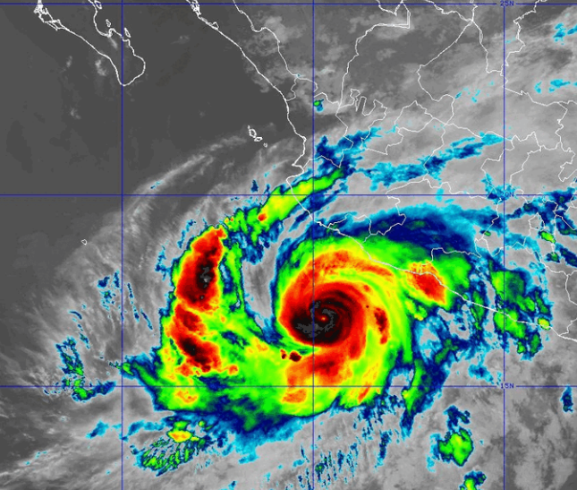
Hurricane Simon intensified to a major hurricane as it moved over the Eastern North Pacific Ocean south of Mexico on Friday.

At 11:00 p.m. EDT on Friday the center of Hurricane Simon was located at latitude 16.8°N and longitude 104.6°W which put the center about 155 miles (250 km) south of Manzanillo, Mexico.   Simon was moving toward the north at 7 m.p.h. (11 km/h).  The maximum sustained wind speed was 120 m.p.h. (195 km/h) and there were wind gusts to 140 m.p.h. (225 km/h).  The minimum surface pressure was 952 mb.

A Hurricane Warning is in effect for the portion of the coast from Punta San Telmo to Punta Mita, Mexico.  The Hurricane Warning includes Manzanillo and Puerto Vallarta.

A Hurricane Watch is in effect for the portion of the coast from Punta Mita to El Roblito, Mexico.

A Hurricane Watch is in effect for Las Islas Marias.

A Tropical Storm Watch is in effect for the portion of the coast from Punta San Telmo to Lazaro Cardenas, Mexico.

Hurricane Simon intensified to a major hurricane on Friday.

A very small eye formed at the center of Hurricane Simon.  The eye was surrounded by a ring of thunderstorms and the strongest winds were occurring in that ring of storms.  Bands of showers and thunderstorms were revolving around the center of Simon’s circulation.  Storms near the center of Simon generated upper level divergence that pumped mass away from the hurricane.  The removal of mass caused the surface pressure to decrease.

The circulation around Hurricane Simon was small.  Winds to hurricane force extended out 20 miles (30 km) from the center of Simon’s circulation.  Winds to tropical storm force extended out 80 miles (130 km) from the center of Hurricane Simon.

The Hurricane Intensity Index (HII) for Hurricane Simon is 22.1.  The Hurricane Size Index (HSI) is 6.1 and the Hurricane Wind Intensity Size Index (HWISI) is 28.2.

Hurricane Simon will move through an environment favorable for intensification during the next 24 hours.  Simon will move over water where the Sea Surface Temperatures are near 30°C.  It will move under the middle of an upper level ridge that is over Mexico and the Eastern North Pacific Ocean.  The upper level ridge winds are weak near the middle of the ridge and there will be little vertical wind shear.  Hurricane Simon will intensify during the next 24 hours.  Simon could intensify rapidly at times.  Hurricane Simon could strengthen to a Category 5 hurricane on Saturday.

Hurricane Simon will move around the western part of a high pressure system that is over Mexico.  The high pressure system will steer Simon toward the north during the next 24 hours.  Hurricane Simon will approach the west coast of Mexico between Manzanillo and Cabo Corrientes on Saturday.

Hurricane Simon is likely to be a major hurricane when it hits the west coast of Mexico.  Simon will bring strong winds and locally heavy rain to the west coast of Mexico.  The strongest winds and heaviest rains will occur in Jalisco and Nayarit.  Heavy rain is likely to cause flash floods in some locations.  Hurricane Simon could cause a storm surge of up to 16 feet (5 meters) along parts of the west coast of Mexico.

Elsewhere over the Eastern North Pacific Ocean, Tropical Storm Rachel started to move toward Baja California.  Tropical Storm Watches and Tropical Storm Warnings were issued for parts of southern California, the northern part of Baja California and northwestern Mexico.

At 11:00 p.m. EDT on Friday the center of Tropical Storm Rachel was located at latitude 23.8°N and longitude 123.3°W which put the center about 720 miles (1160 km) south-southwest of San Diego, California.  Rachel was moving toward the northeast at 9 m.p.h. (15 km/h).  The maximum sustained wind speed was 45 m.p.h. (75 km/h) and there were wind gusts to 60 m.p.h. (95 km/h).  The minimum surface pressure was 995 mb.

A Tropical Storm Warning is in effect for the portion of the coast from San Jose de Las Palomas, Mexico to the Mexico/U.S. border.

A Tropical Storm Warning is in effect for the portion of the coast from Isla San Luis to Puerto Penasco, Mexico.

A Tropical Storm Watch is in effect for the portion of the coast from the U.S./Mexico border to the San Diego County/Orange County line in California.

A Tropical Storm Watch is in effect for the portion of the coast from Isla San Luis to Bahia de Los Angeles, Mexico.

A Tropical Storm Watch is in effect for the portion of the coast from Puerto Libertad to Puerto Penasco, Mexico.

Hurricane Lowell Brings Wind and Rain to Kauai

Hurricane Lowell brought wind and rain to Kauai on Monday night.  At 8:00 a.m. EDT on Tuesday the center of Hurricane Lowell was located at latitude 22.9°N and longitude 160.8°W which put the center about 110 miles (175 km) northwest of Lihue, Hawaii.  Lowell was moving toward the north at 18 m.p.h. (30 km/h).  The maximum sustained wind speed was 105 m.p.h. (165 km/h) and there were wind gusts to 125 m.p.h. (200 km/h).  The minimum surface pressure was 965 mb.

A Hurricane Warning is in effect for Kauai County including Kauai and Niihau.

A Hurricane Warning is in effect for the Papahanaumokuakea Marine National Monument from Nihoa to French Frigate Shoals.

A Tropical Storm Warning is in effect for Oahu.

A weather station at the Lihue Airport was reporting a sustained wind speed of 53 m.p.h (85 km/h) and a wind gust of 79 m.p.h (127 km/h).

A weather station at the Honolulu Airport reported a sustained wind speed of 26 m.p.h. (42 km/h) and a wind gust of 45 m.p.h. (73 km/h).

Hurricane Lowell was a Category 2 hurricane on the Saffir-Simpson Scale as it passed over Kauai on Monday night.  The center of Lowell’s circulation passed west of Kauai and Niihau.  An eye was no longer visible at the center of Hurricane Lowell.  Bands of showers and thunderstorms were revolving around the center of Lowell’s circulation.  Storms near the center generated upper level divergence that pumped more mass away from the hurricane.  The removal of mass in the upper levels was less than to the convergence of mass in the lowers levels of the atmosphere.  So, the surface pressure was increasing.

The distribution of wind speeds in Hurricane Lowell was fairly symmetrical.  Winds to hurricane force extended out 65 miles (105 km) from the center of Lowell’s circulation.  Winds to tropical storm force extended out 175 miles (280 km) from the center of Hurricane Lowell.

The Hurricane Intensity Index (HII) for Hurricane Lowell is 17.8.  The Hurricane Size Index (HSI) is 23.9 and the Hurricane Wind Intensity Size Index (HWISI) is 41.7.  Hurricane Lowell is similar in size and intensity to Hurricane Gustav when Gustav hit Louisiana in 2008.

Hurricane Lowell will move through an environment that will be unfavorable for intensification during the next 24 hours.  Lowell will move over water where the Sea Surface Temperatures are near 26°C.  It will move under the southeastern part of an upper level low that is northwest of Hawaii.  The upper level low will produce southwesterly winds that will blow toward the top of Lowell’s circulation.  Those winds will cause strong vertical wind shear.  Hurricane Lowell will continue to weaken on Tuesday because of the strong vertical wind shear.

The upper level low that is northwest of Hawaii will pull Hurricane Lowell toward the north during the next 24 hours.  On its anticipated track, Hurricane Lowell will move away from  Kauai and Niihau on Tuesday.

Bands in the eastern side of Lowell will bring strong winds and heavy rain to Kauai and Niihau during the next few hours.  Heavy rain could cause flash floods in some locations.

Flood Watches are in effect for Kauai and Niihau.

Bands in the eastern periphery of Hurricane Lowell could also drop heavy rain on Maui, Lanai, Molokai, Oahu, the Big Island of Hawaii, and Kahoolawe.

Flood Watches are in effect for Maui, Lanai, Molokai, Oahu, the Big Island of Hawaii, and Kahoolawe.

Elsewhere, Tropical Storm Marie continued to weaken gradually southwest of San Diego.

At 5:00 a.m. EDT on Tuesday the center of Tropical Storm Marie was located at latitude 25.5°N and longitude 126.6°W which put the center about 760 miles (1220 km) southwest San Diego, California.  Marie was moving toward the west-northwest at 8 m.p.h. (13 km/h).  The maximum sustained wind speed was 45 m.p.h. (75 km/h) and there were wind gusts to 60 m.p.h. (95 km/h).  The minimum surface pressure was 996 mb.

Hurricane Lowell Moves Closer to Kauai

Hurricane Lowell was moving closer to Kauai on Monday evening.  At 11:00 p.m. EDT on Monday the center of Hurricane Lowell was located at latitude 20.3°N and longitude 161.3°W which put the center about 170 miles (275 km) southwest of Lihue, Hawaii.  Lowell was moving toward the north-northeast at 18 m.p.h. (30 km/h).  The maximum sustained wind speed was 110 m.p.h. (175 km/h) and there were wind gusts to 130 m.p.h. (210 km/h).  The minimum surface pressure was 956 mb.

A Hurricane Warning is in effect for Kauai County including Kauai and Niihau.

A Hurricane Warning is in effect for the Papahanaumokuakea Marine National Monument from Nihoa to French Frigate Shoals.

A Tropical Storm Warning is in effect for Oahu.

A weather station at the Lihue Airport was reporting a sustained wind speed of 32 m.p.h (52 km/h) and a wind gust of 51 m.p.h (82 km/h).

Hurricane Lowell was a Category 2 hurricane on the Saffir-Simpson Scale as it moved closer to Kauai on Monday evening.  A small circular eye was at the center of Lowell’s circulation.  The eye was surrounded by a ring of thunderstorms and the strongest winds were occurring in that ring of storms.  Bands of showers and thunderstorms were revolving around the center of Hurricane Lowell.  Storms near the center generated upper level divergence that pumped more mass away from the hurricane.  The removal of mass in the upper levels was a little less than to the convergence of mass in the lowers levels of the atmosphere.  So, the surface pressure was increasing slowly.

The distribution of wind speeds in Hurricane Lowell was fairly symmetrical.  Winds to hurricane force extended out 65 miles (105 km) from the center of Lowell’s circulation.  Winds to tropical storm force extended out 175 miles (280 km) from the center of Hurricane Lowell.

The Hurricane Intensity Index (HII) for Hurricane Lowell is 19.2.  The Hurricane Size Index (HSI) is 22.3 and the Hurricane Wind Intensity Size Index (HWISI) is 41.5.  Hurricane Lowell is similar in size and intensity to Hurricane Gustav when Gustav hit Louisiana in 2008.

Hurricane Lowell will move through an environment that will be unfavorable for intensification during the next 24 hours.  Lowell will move over water where the Sea Surface Temperatures are near 27°C.   It will move under the southwestern part of an upper level low that is north of Hawaii. The upper level low will produce southwesterly winds that will blow toward the top of Lowell’s circulation.  Those winds will cause the vertical wind shear to increase.  Hurricane Lowell will continue to weaken on Tuesday because of the increase in vertical wind shear.

The upper level low that is north of Hawaii will pull Hurricane Lowell toward the north-northeast during the next 24 hours.  On its anticipated track, the center of Hurricane Lowell will pass just to the west of Kauai in a few hours.

Bands in the eastern side of Lowell will bring strong winds and heavy rain to Kauai and Niihau on Monday night.  Heavy rain could cause flash floods in some locations.

Flood Watches are in effect for Kauai and Niihau.

Bands in the eastern periphery of Hurricane Lowell could also drop heavy rain on Maui, Lanai, , Molokai, Oahu, the Big Island of Hawaii, and Kahoolawe.

Flood Watches are in effect for Maui, Lanai, Molokai, Oahu, the Big Island of Hawaii, and Kahoolawe.

Elsewhere, Tropical Storm Marie continued to weaken gradually southwest of San Diego.

At 11:00 p.m. EDT on Monday the center of Tropical Storm Marie was located at latitude 25.1°N and longitude 125.9°W which put the center about 745 miles (1200 km) southwest San Diego, California.  Marie was moving toward the west-northwest at 8 m.p.h. (13 km/h).  The maximum sustained wind speed was 50 m.p.h. (80 km/h) and there were wind gusts to 65 m.p.h. (105 km/h).  The minimum surface pressure was 994 mb.

Hurricane Warning Issued for Kauai

A Hurricane Warning has been issued for Kauai County.  At 8:00 a.m. EDT on Monday the center of Hurricane Lowell was located at latitude 17.0°N and longitude 163.0°W which put the center about 415 miles (670 km) southwest of Lihue, Hawaii.  Lowell was moving toward the north-northeast at 10 m.p.h. (16 km/h).  The maximum sustained wind speed was 115 m.p.h. (185 km/h) and there were wind gusts to 135 m.p.h. (215 km/h).  The minimum surface pressure was 940 mb.

A Hurricane Warning is in effect for Kauai County including Kauai and Niihau.

A Hurricane Warning is in effect for the Papahanaumokuakea Marine National Monument from Nihoa to French Frigate Shoals.

Hurricane Lowell was weakening slowly as it moved toward Kauai on Monday morning.  Lowell was still a major hurricane.  A circular eye with a diameter of 35 miles (55 km) was still at the center of Lowell’s circulation.  The eye was surrounded by a ring of thunderstorms and the strongest winds were occurring in that ring of storms.  Bands of showers and thunderstorms were revolving around the center of Hurricane Lowell.  Storms near the center generated upper level divergence that pumped more mass away from the hurricane.  The removal of mass in the upper levels was a little less than to the convergence of mass in the lowers levels of the atmosphere.  So, the surface pressure was increasing slowly.

The distribution of wind speeds in Hurricane Lowell was fairly symmetrical. Winds to hurricane force extended out 60 miles (95 km) from the center of Lowell’s circulation.  Winds to tropical storm force extended out 175 miles (280 km) from the center of Hurricane Lowell.

The Hurricane Intensity Index (HII) for Hurricane Lowell is 20.6. The Hurricane Size Index (HSI) is 19.5 and the Hurricane Wind Intensity Size Index (HWISI) is 40.1.  Hurricane Lowell is similar in intensity to Hurricane Rita was when Rita hit Southwest Louisiana in 2005.  Lowell is not as big as Rita was.

Hurricane Lowell will move through an environment that will be unfavorable for intensification during the next 24 hours.  Lowell will move over water where the Sea Surface Temperatures are near 27°C.  It will move under the southwestern part of an upper level low that is north of Hawaii.  The upper level low will produce southwesterly winds that will blow toward the top of Lowell’s circulation.  Those winds will cause the vertical wind shear to increase.  Hurricane Lowell will continue to weaken on Monday because of the increase in vertical wind shear.

The upper level low that is north of Hawaii will steer Hurricane Lowell toward the north-northeast during the next 24 hours.  On its anticipated track, the center of Hurricane Lowell will be just southwest of Kauai on Monday night.

Bands in the eastern side of Lowell could bring strong winds and heavy rain to Kauai and Niihau on Monday night.  Heavy rain could cause flash floods in some locations.

Flood Watches are in effect for Kauai and Niihau.

Bands in the eastern periphery of Hurricane Lowell could also drop heavy rain on Maui, Lanai, , Molokai, Oahu, the Big Island of Hawaii, and Kahoolawe.

Flood Watches are in effect for Maui, Lanai, Molokai, Oahu, the Big Island of Hawaii, and Kahoolawe.

Elsewhere, Tropical Storm Marie was weakening gradually southwest of San Diego.

At 5:00 a.m. EDT on Monday the center of Tropical Storm Marie was located at latitude 24.4°N and longitude 123.7°W which put the center about 700 miles (1125 km) southwest San Diego, California.  Marie was moving toward the northwest at 8 m.p.h. (13 km/h).  The maximum sustained wind speed was 65 m.p.h. (105 km/h) and there were wind gusts to 80 m.p.h. (130 km/h).  The minimum surface pressure was 986 mb.

Tropical Storm Hilary Drops Heavy Rain on Southern California

Tropical Storm Hilary dropped heavy rain over parts of southern California on Sunday. At 5:00 p.m. EDT on Sunday the center of Tropical Storm Hilary was located at latitude 31.3°N and longitude 116.1°W which put it about 115 miles (185 km) south-southeast of San Diego, California. Hilary was moving toward the north at 23 m.p.h. (37 km/h). The maximum sustained wind speed was 60 m.p.h. (95 km/h) and there were wind gusts to 75 m.p.h. (120 km/h). The minimum surface pressure was 990 mb.

A Tropical Storm Warning was in effect for the portion of the coast from the U.S. border with Mexico to the Point Mugu, California. The Tropical Storm Warning included San Diego. The Tropical Storm Warning also included Catalina Island. A Tropical Storm Warning was in effect for the portion of the coast from Punta Eugenia, Mexico to the border with the U.S. A Tropical Storm Warning was in effect for the portion of the coast from Bahia San Bautista to Guaymas, Mexico.

Former Hurricane Hilary weakened to a tropical storm as the center of Hilary moved over the northern part of Baja California. Bands in the northern part of Hilary’s circulation brought gusty winds to parts of southern California and Arizona. Winds to tropical storm force extended out 230 miles (370 km) from the center of Hilary’s circulation. A weather station at the Imperial, California airport reported a sustained wind speed of 40 m.p.h. (65 km/h) and a wind gust of 61 m.p.h. (98 km/h). A weather station in Yuma, Arizona reported at sustained wind speed of 45 m.p.h. (75 km/h) and a wind gust of 59 m.p.h. (95 km/h).

The circulation around the northern side of Tropical Storm Hilary interacted with an upper level low west of California to drop heavy rain over parts of southern California. Weather stations in Carlsbad, Ramona, Los Angeles, Riverside, Big Bear, Borrego, Palmdale, Edwards Air Force Base, and Gray Butte, California were all reporting heavy rain at 7:00 p.m. EDT.

The upper low west of California will pull Tropical Storm Hilary quickly to the north during the next 24 hours. The center of Hilary’s circulation will pass east of San Diego on Sunday evening. Tropical Storm Hilary continue to weaken as it moves inland over the Southwest U.S. The circulation of Hilary will move over Nevada on Monday. The upper and lower parts of Hilary’s circulation could decouple because of strong vertical wind shear. Tropical Storm Hilary will continue to produce gusty winds and locally heavy rain during the next 24 hours. The heaviest rain is likely to fall where the wind forces the air to rise over mountains. Heavy rain is likely to cause flash floods in some locations. Flood Watches have been issued for parts of southern California, southern Nevada, southern Utah and western Arizona. Hilary could also bring strong winds to mountains in southern Nevada, southern Utah and western Arizona.

Hurricane Hilary Brings Wind and Rain to Baja California

Hurricane Hilary brought wind and rain to Baja California on Saturday night. At 11:00 p.m. EDT on Saturday the center of Hurricane Hilary was located at latitude 25.3°N and longitude 114.6°W which put it about 175 miles (280 km) south of Punta Eugenia, Mexico. Hilary was moving toward the north-northwest at 18 m.p.h. (30 km/h). The maximum sustained wind speed was 90 m.p.h. (145 km/h) and there were wind gusts to 105 m.p.h. (165 km/h). The minimum surface pressure was 968 mb.

Even though center of Hurricane Hilary was south of Punta Eugenia, Hilary brought strong winds and locally heavy rain to Baja California on Saturday night. A weather station in Loreto, Mexico reported a sustained wind speed of 58 m.p.h. (93 km/h) and a wind gust of 69 m.p.h. (111 km/h). There were reports of flash floods in Santa Rosalia, Mexico.

A Hurricane Warning was in effect for the portion of the coast from Punta Abreojos to Cabo San Quintin, Mexico. A Hurricane Watch was in effect for the portion of the coast from Cabo San Quintin to Ensenada, Mexico. A Tropical Storm Warning was in effect for the portion of the coast from Punta Abreojos to Todos Santos, Mexico. A Tropical Storm Warning was in effect for the portion of the coast from Los Barriles to Guaymas, Mexico. A Tropical Storm Warning was in effect for the portion of the coast from the U.S. border with Mexico to the Point Mugu, California. The Tropical Storm Warning included San Diego. The Tropical Storm Warning also included Catalina Island. A Tropical Storm Warning was in effect for the portion of the coast from Cabo San Quintin, Mexico to the border with the U.S. A Tropical Storm Watch was in effect for the portion of the coast from Guaymas to Huatabampito, Mexico.

Hurricane Hilary was weakening on Saturday night. There was no longer an eye visible on satellite images of Hurricane Hilary. The distribution of thunderstorms in Hilary was asymmetrical. Many of the thunderstorms were occurring in bands in the northern half of Hilary’s circulation. Bands in the southern half of the circulation consisted primarily of showers and lower clouds.

The circulation around Hurricane Hilary was still large even though Hilary was weakening. Winds to hurricane force extended out 45 miles (75 km) from the center of Hilary’s circulation. Winds to tropical storm force extended out 265 miles (425 km) from the center of circulation. The Hurricane Intensity Index (HII) was 13.9. The Hurricane Size Index (HSI) was 18.7 and the Hurricane Wind Intensity Size Index (HWISI) was 32.6. Hurricane Hilary was similar in size and intensity to Hurricane Matthew when Matthew hit South Carolina in 2016.

Hurricane Hilary will be moving into an environment that will be unfavorable for a hurricane during the next 24 hours. Hilary will move over water where the Sea Surface Temperatures are colder than 26°C. It will move between an upper level ridge over Mexico and the south central U.S. and an upper level low west of California. The upper level ridge and upper level low will interact to produce northerly winds that will blow toward the top of Hilary’s circulation. Those winds will cause the vertical wind shear to increase. The combination of cooler water and more vertical wind shear will cause Hurricane Hilary to weaken during the next 24 hours. In addition, much of the circulation in the eastern side of Hurricane Hilary will pass over Baja California. The mountains in Baja California will partially disrupt the flow of air around Hurricane Hilary.

The upper level ridge over the south central U.S. and the upper level low west of California will steer Hurricane Hilary toward the north-northwest during the next 24 hours. On its anticipated track, the center of Hurricane Hilary will be near Punta Eugenia early Sunday morning. Hilary will continue to produce strong, gusty winds and locally heavy rain in Baja California on Sunday. Heavy rain is likely to cause flash floods in some locations.

Hurricane Hilary could take a track similar to the one taken by Hurricane Nora in 1997. The center of Hilary will reach southern California by Sunday evening. Hilary will weaken to a tropical storm before it reaches southern California. Hilary will bring strong winds and locally heavy rain to parts of southern California. The heaviest rain is likely to fall where the wind force the air to rise over mountains. Heavy rain is likely to cause flash floods in some locations. Flood Watches have been issued for parts of southern California, southern Nevada, southern Utah and western Arizona. Hilary could also bring strong winds to mountains in southern Nevada, southern Utah and western Arizona.

Hurricane Hilary Moves Toward Baja California

Hurricane Hilary was moving toward Baja California on Saturday morning. At 8:00 a.m. EDT on Saturday the center of Hurricane Hilary was located at latitude 21.5°N and longitude 113.4°W which put it about 490 miles (790 km) south-southeast of Punta Eugenia, Mexico. Hilary was moving toward the north-northwest at 13 m.p.h. (21 km/h). The maximum sustained wind speed was 130 m.p.h. (210 km/h) and there were wind gusts to 155 m.p.h. (250 km/h). The minimum surface pressure was 943 mb.

A Hurricane Warning was in effect for the portion of the coast from Punta Abreojos to Cabo San Quintin, Mexico. A Hurricane Watch was in effect for the portion of the coast from Cabo San Quintin to Ensenada, Mexico. A Tropical Storm Warning was in effect for the portion of the coast from Punta Abreojos to Guaymas, Mexico. The Tropical Storm Warning included Cabo San Lucas. A Tropical Storm Warning was in effect for the portion of the coast from the U.S. border with Mexico to the Point Mugu, California. The Tropical Storm Warning included San Diego. The Tropical Storm Warning also included Catalina Island. A Tropical Storm Warning was in effect for the portion of the coast from Cabo San Quintin, Mexico to the border with the U.S. A Tropical Storm Watch was in effect for the portion of the coast from Guaymas to Huatabampito, Mexico.

Hurricane Hilary was moving closer to Baja California on Saturday morning. An eye with a diameter of 30 miles (50 km) was at the center of Hilary’s circulation. The eye was surrounded by a ring of thunderstorms and the strongest winds were occurring in that ring of storms. Bands of showers and thunderstorms were revolving around the core of Hurricane Hilary. Storms near the core generated upper level divergence that pumped mass away from the hurricane.

The circulation around Hurricane Hilary was large. Winds to hurricane force extended out 50 miles (80 km) from the center of Hilary’s circulation. Winds to tropical storm force extended out 265 miles (425 km) from the center of circulation. The Hurricane Intensity Index (HII) was 25.1. The Hurricane Size Index (HSI) was 19.2 and the Hurricane Wind Intensity Size Index (HWISI) was 44.3. Hurricane Hilary was capable of causing regional major damage.

Hurricane Hilary appeared to be starting to weaken on Saturday morning. Thunderstorms were weakening in bands in the western side of Hilary’s circulation. Some of the bands in the western part of Hilary consisted primarily of showers and lower clouds. Northerly winds in the western half of Hurricane Hilary were pulling cooler, drier air into that part of the hurricane.

Hurricane Hilary will be moving into an environment that will become unfavorable for a major hurricane during the next 24 hours. Hilary will move over water where the Sea Surface Temperatures are cooler than 27°C. It will move between an upper level ridge over Mexico and the south central U.S. and an upper level low west of California. The upper level ridge and upper level low will interact to produce northerly winds that will blow toward the top of Hilary’s circulation. Those winds will cause the vertical wind shear to increase. The combination of cooler water and more vertical wind shear will cause Hurricane Hilary to weaken during the next 24 hours.

The upper level ridge over the south central U.S. and the upper level low west of California will steer Hurricane Hilary toward the north-northwest during the next 24 hours. On its anticipated track, the center of Hurricane Hilary will approach Punta Eugenia on Saturday night. Hilary will bring strong, gusty winds and locally heavy rain to Baja California. Heavy rain is likely to cause flash floods in some locations.

Hilary will reach southern California on Sunday. Hilary is likely to weaken to a tropical storm before it reaches southern California. Hilary bring strong winds and locally heavy rain to parts of southern California. Heavy rain is likely to cause flash floods in some locations. Flood Watches have been issued for parts of southern California, southern Nevada, southern Utah and western Arizona. Hilary could also bring strong winds to mountains in southern Nevada, southern Utah and western Arizona.

Hilary Prompts Hurricane Warning for Baja, Tropical Storm Watch for Southern California

The potential threat from Hurricane Hilary prompted the issuance of a Hurricane Warning for part of Baja California and a Tropical Storm Watch for Southern California on Friday morning. At 11:00 a.m. EDT on Friday the center of Hurricane Hilary was located at latitude 17.9°N and longitude 111.4°W which put it about 360 miles (575 km) south-southwest of Cabo San Lucas, Mexico. Hilary was moving toward the northwest at 10 m.p.h. (16 km/h). The maximum sustained wind speed was 145 m.p.h. (230 km/h) and there were wind gusts to 170 m.p.h. (280 km/h). The minimum surface pressure was 939 mb.

A Hurricane Warning was in effect for the portion of the coast from Punta Abreojos to Punta Eugenia, Mexico. A Hurricane Watch was in effect for the portion of the coast from Punta Eugenia to Ensenada, Mexico. A Tropical Storm Warning was in effect for the portion of the coast from Punta Abreojos to Loreto, Mexico. The Tropical Storm Warning includes Cabo San Lucas. A Tropical Storm Watch was in effect for the portion of the coast from the U.S. border with Mexico to the Orange/Los Angeles County Line. The Tropical Storm Watch included Catalina Island. A Tropical Storm Watch was in effect for the portion of the coast from Ensenada, Mexico to the border with the U.S. A Tropical Storm Watch was in effect for the portion of the coast from Loreto to Huatabampito, Mexico.

Hurricane Hilary continued to intensify on Friday morning. A circular eye with a diameter of 20 miles (30 km) was at the center of Hilary’s circulation. The eye was surrounded by a ring of thunderstorms and the strongest winds were occurring in that ring of storms. Bands of showers and thunderstorms were revolving around the core of Hurricane Hilary. Storms near the core generated upper level divergence that pumped mass away from the hurricane.

The circulation around Hurricane Hilary was large. Winds to hurricane force extended out 45 miles (75 km) from the center of Hilary’s circulation. Winds to tropical storm force extended out 290 miles (465 km) from the center of circulation. The Hurricane Intensity Index (HII) was 29.9. The Hurricane Size Index (HSI) was 16.9 and the Hurricane Wind Intensity Size Index (HWISI) was 46.8. Hurricane Hilary was similar in size and intensity to Hurricane Ida when Ida hit Louisiana in 2021.

Hurricane Hilary will move through an environment favorable for a major hurricane during the next 24 hours. Hilary will move over water where the Sea Surface Temperatures are near 30°C. It will move through a region where the upper level winds are weak and there will be little vertical wind shear. Hurricane Hilary could intensify during the next 24 hours. However, if the inner end of a rainband wraps around the existing eye and eyewall, then concentric eyewalls could form. If concentric eyewalls form, then an eyewall replacement cycle could cause Hilary to weaken.

Hurricane Hilary will move around the western part of a high pressure system over Mexico and the south central U.S. The high pressure system will steer Hilary toward the north-northwest during the next 24 hours. On its anticipated track Hurricane Hilary will move toward Baja California. Hilary will move more toward the north when it reaches the western end of the high pressure system during the weekend. The center of Hurricane Hilary will be near Punta Eugenia on Sunday morning. Hurricane Hilary will start to affect Baja California on Saturday. Hilary will bring strong, gusty winds and locally heavy rain to Baja California. Heavy rain is likely to cause flash floods in some locations.

The center of Hurricane Hilary is likely to approach southern California on Sunday night. There is cooler water west of the northern part of Baja California. Hilary will be weakening when it approaches southern California. Hilary bring strong winds and locally heavy rain to parts of southern California. Heavy rain is likely to cause flash floods in some locations. Flood Watches have been issued for parts of southern California, southern Nevada, southern Utah and western Arizona.

Tropical Storm Kay Brings Rain to Southern California

Tropical Storm Kay brought rain to parts of southern California. At 2:00 p.m. EDT on Friday the center of Tropical Storm Kay was located at latitude 30.7°N and longitude 117.2°W which put it about 140 miles (225 km) south of San Diego, California. Kay was moving toward the northwest at 13 m.p.h. (20 km/h). The maximum sustained wind speed was 45 m.p.h. (75 km/h) and there were wind gusts to 60 m.p.h. (95 km/h). The minimum surface pressure was 992 mb.

A Tropical Storm Warning was in effect for the portion of the coast from Punta Eugenia, Mexico to the border with the U.S. A Tropical Storm Warning was also in effect for the portion of the coast from Bahia De Los Angeles to Puerto Libertad, Mexico.

Rainbands in the northern side of Tropical Storm Kay dropped rain over parts of southern California. Heavy rain was also falling over parts of northwestern Mexico and there were reports of flash floods in that region. The center of Tropical Storm Kay was over the Eastern North Pacific Ocean south of San Diego. Bands of showers and thunderstorms were revolving around the center of Kay’s circulation. Winds to tropical storm force extended out 200 miles (320 km) from the center of circulation. The strongest winds were occurring over the Eastern North Pacific and the Gulf of California. Strong wind gusts were also reported in mountains in northwestern Mexico and southern California.

Tropical Storm Kay will continue to weaken gradually. Kay will move over water where the Sea Surface Temperatures are near 22˚C. As Tropical Storm Kay weakens, the clouds will not rise as high in the atmosphere and Kay will be steered by the winds closer to the surface. Those winds will steer Tropical Storm Kay toward the west during the next 36 hours. The rain over southern California will diminish during the weekend as Kay moves westward and weakens.